August 16 , 2018.
Hawai , Kilauea :
Tuesday, August 14, 2018, 9:31 AM HST (Tuesday, August 14, 2018, 19:31 UTC)
19°25’16 » N 155°17’13 » W,
Summit Elevation 4091 ft (1247 m)
Current Volcano Alert Level: WARNING
Current Aviation Color Code: ORANGE
Activity and Hazards Overview
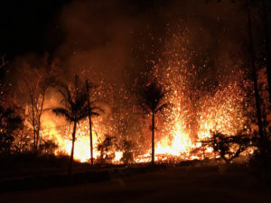
Kīlauea Volcano has remained quiet for over a week now, with no further collapse events at the summit, and, with the exception of a small, crusted-over pond of lava deep inside the fissure 8 cone and a few scattered ocean entries, no lava flowing in the lower East Rift Zone (LERZ).
Earthquake and deformation data show no net accumulation, withdrawal, or significant movement of subsurface magma or pressurization as would be expected if the system was building toward a resumption of activity.
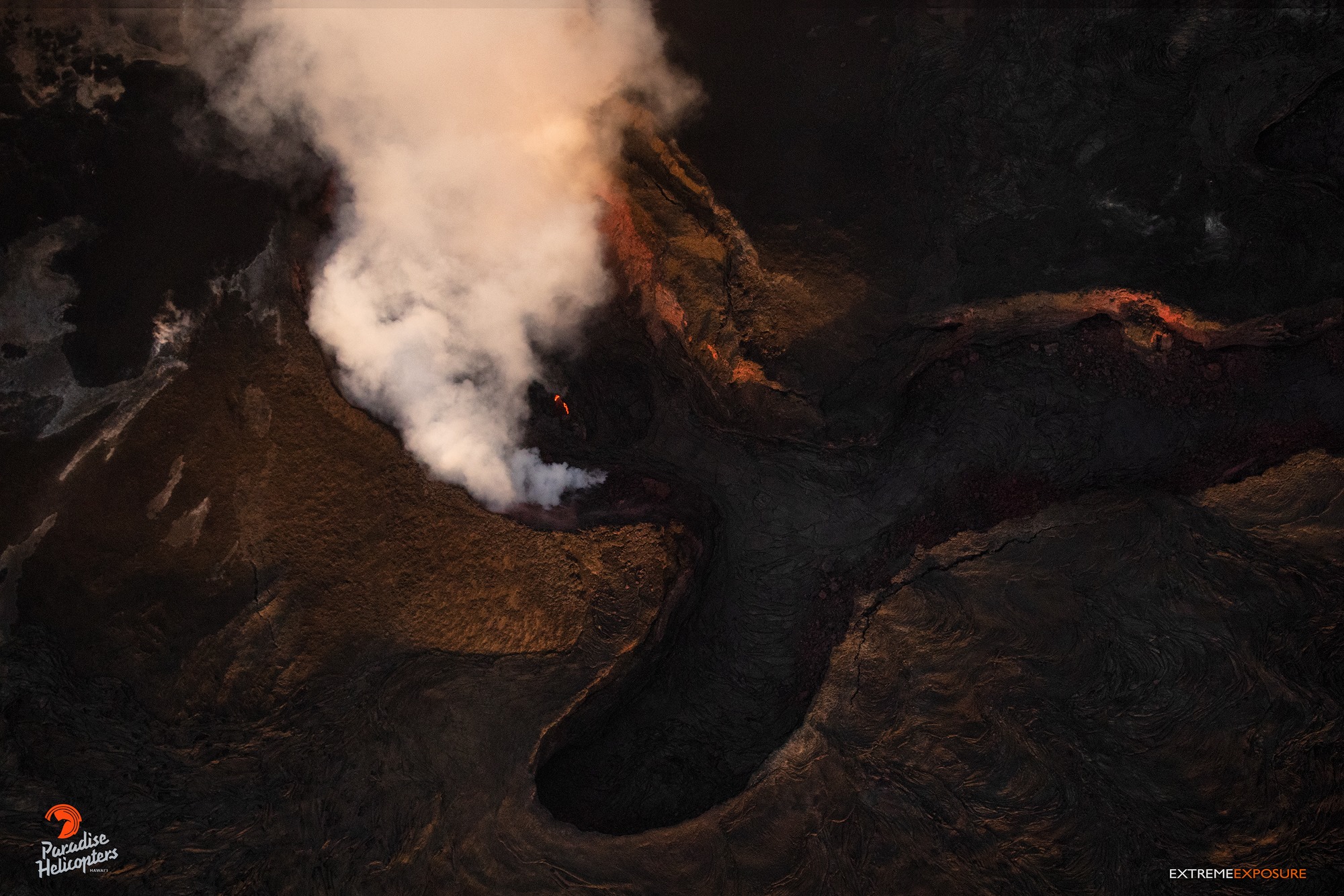
Sunday, Aug 12, 2018, 6:00 am – Kilauea’s lower east rift zone overflight: Just a couple glowing spots within fissure 8 remain, as the pond’s surface has almost completely crusted over. Gases continue to diffuse from fumaroles within the pu‘u, and along the rift.
It is too soon to tell if this change represents a temporary lull or the end of the LERZ eruption and/or summit collapse activity. In 1955, similar pauses of 5 and 16 days occurred during an 88-day-long LERZ eruption. During the Mauna Ulu eruption (1969-1974), a 3.5 month pause occurred in late 1971.
Despite the eruptive pause, hazardous conditions remain in the LERZ and at the summit as described below:
– The fissure 8 crater still hosts a small amount of lava that currently does not enter the existing channel. Should the eruption rate increase, the configuration of outflow around the vent could change, sending lava in new directions. Possible flow paths to the north have been outlined in HVO’s 2018 lower East Rift Zone hazard assessment ).
– Resupply of magma could lead to the reactivation of fissures other than fissure 8, or the opening of entirely new fissures along the ERZ, potentially leading to new areas being inundated by lava.
– The new lava flow field in the LERZ includes large areas of still-hot, rugged, and unstable lava surfaces that are subject to collapse.
– Sulfur dioxide (SO2) gas emissions have greatly decreased from LERZ vents, but high levels of SO2 may persist in downwind areas.
– Tephra (fragments of glassy lava) have accumulated to thicknesses of more than several feet near fissure 8. This material breaks down over time into small, glassy particles that can be blown on the wind and create an eye, respiratory, and skin irritant. Disturbing the tephra by sweeping, shoveling, or driving over it will break the fragile pieces into a glassy dust. The tephra can also conceal underlying hazards such as ground cracks, holes, and debris from destroyed structures.
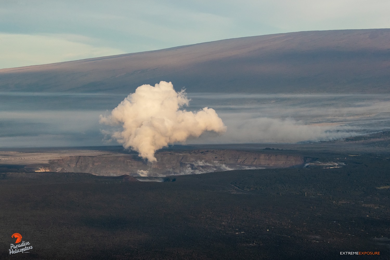
Kīlauea caldera and Halema‘uma‘u are dwarfed by Mauna Loa in the distance.
– The LERZ ocean entry is minimally active at this time, but continued laze and lava delta collapses remain a concern. Hydrovolcanic explosions are much less of a concern now, as they require high eruption rates with lava entering the ocean, but they may still occur.
– At the summit, additional earthquakes, rockfalls, and ground cracking can occur with no warning. Steep crater walls destabilized by months of earthquakes could be prone to collapse for weeks or months to come, even without further ground shaking ).
– Summit SO2 emissions rates are lower than at any time since late 2007 and are not currently a hazard.
– Resuspended ash in the summit region remains a local hazard during strong winds.
– As the summit continues to adjust to changes in the underlying magmatic system, additional, and potentially damaging, earthquakes are possible. Hawai’i is known for frequent earthquakes, so all residents should be prepared for damaging earthquakes.
– If magma returns to the shallow reservoir beneath Kilauea’s summit, groundwater could encounter subsurface regions of high temperature, prompting explosions of uncertain size.
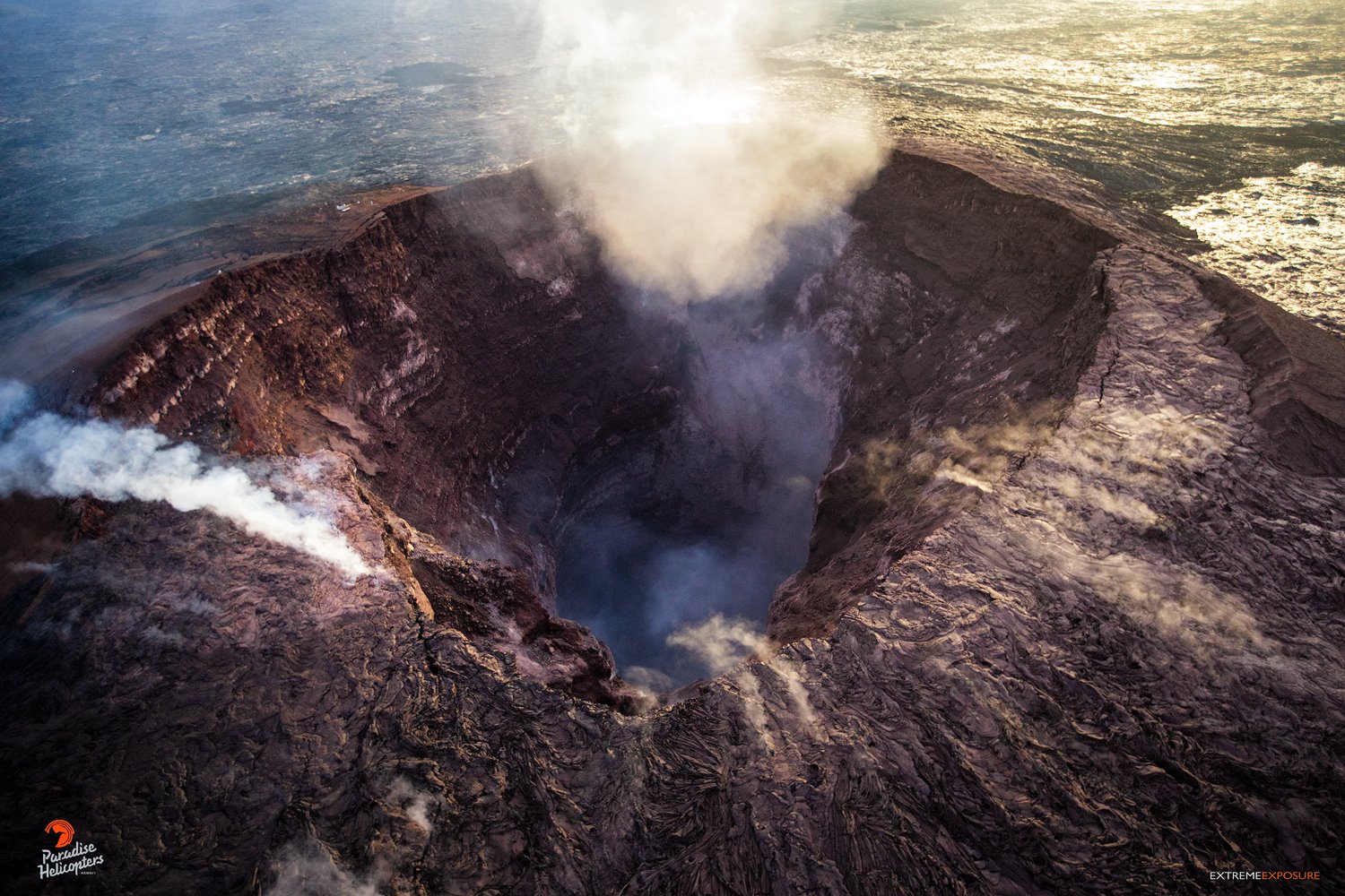
Pu‘u ‘O‘o looks entirely different from before this eruption…
– More dangerous explosive activity at the summit remains very unlikely in the near term.
– Aftershocks from the May 4, 2018 M6.9 earthquake below Kilauea’s south flank will continue for months more and could produce moderate, damaging events at any time.
The Hawaiian Volcano Observatory (HVO) will continue to closely monitor Kīlauea’s activity, including overflights of the rift zone and summit as needed, supplemented with unmanned aerial systems (UAS) flights and daily visual observations. Field crews will be deployed to the LERZ and the summit areas to collect data and to install and repair monitoring instruments. HVO will continue to issue daily updates and additional messages as needed.
Source : HVO
Photo : Bruce Omori
Colombia, Chiles / Cerro Negro :
Subject: Activity bulletin of Chiles and Cerro Negro volcanoes
The level of activity of volcanoes is maintained at the level:
YELLOW LEVEL ■ (III): CHANGES IN THE BEHAVIOR OF VOLCANIC ACTIVITY
Following the activity of the CHILE volcanoes and CERRO NEGRO, the COLOMBIAN GEOLOGICAL SERVICE (SGC) reports that:
In the period between August 7 and 13, 2018, seismicity in the region of Chiles – Cerro Negro volcanoes, showed a considerable decrease in the frequency of earthquakes of about 80% compared to the previous week. The predominance of earthquakes associated with rock fracturing inside the volcanic building continues (VT type earthquakes).
The events, which by their characteristics could be located, were dispersed, with distances up to 8 km and depths less than 7 km from the average height of the summit of the Chiles volcano (4700 m). The local magnitude of seismicity under these volcanoes ranged from -0.2 to 1.6 on the Richter scale.
The Colombian Geological Service and the ECUADOR INSTITUTO GEOFÍSICO DE LA ESCUELA POLITECNICA NACIONAL closely follow the evolution of this seismic and volcanic activity and will report without delay on the changes detected.
Source : Ingeominas
Costa Rica , Rincon de la Vieja :
10.83°N, 85.324°W
Elevation 1916 m
OVSICORI-UNA reported that a three-minute-long eruption at Rincón de la Vieja began at 1828 on 14 August. Foggy conditions prevented webcam views and an estimate of a plume height.
Activity report of the Rincón de la Vieja volcano
2018-08-14
On 14/08/2018 at 18:28 local time, there is an eruption on the volcano Rincón de la Vieja. The height reached by the column is unknown because of the visibility conditions of the site.
Duration of the activity: 3 minutes.
Ashfall: There are no reports
Sulfur odor: There are no reports
Comments: The volcano is shrouded in fog and is therefore not appreciated by the webcam.
Source : GVP , Ovsicori
Philippines , Kanlaon :
KANLAON VOLCANO BULLETIN 16 August 2018 08:00 A.M.
Kanlaon Volcano’s seismic monitoring network recorded forty-four (44) volcanic earthquakes during the past 24 hours. Ground deformation data from continuous GPS measurements indicate a more pronounced inflation of the edifice since December 2017, signifying pressurization beneath the edifice. Sulfur dioxide (SO2) emission was measured at an average of 2,131 tonnes/day on 04 July 2018.
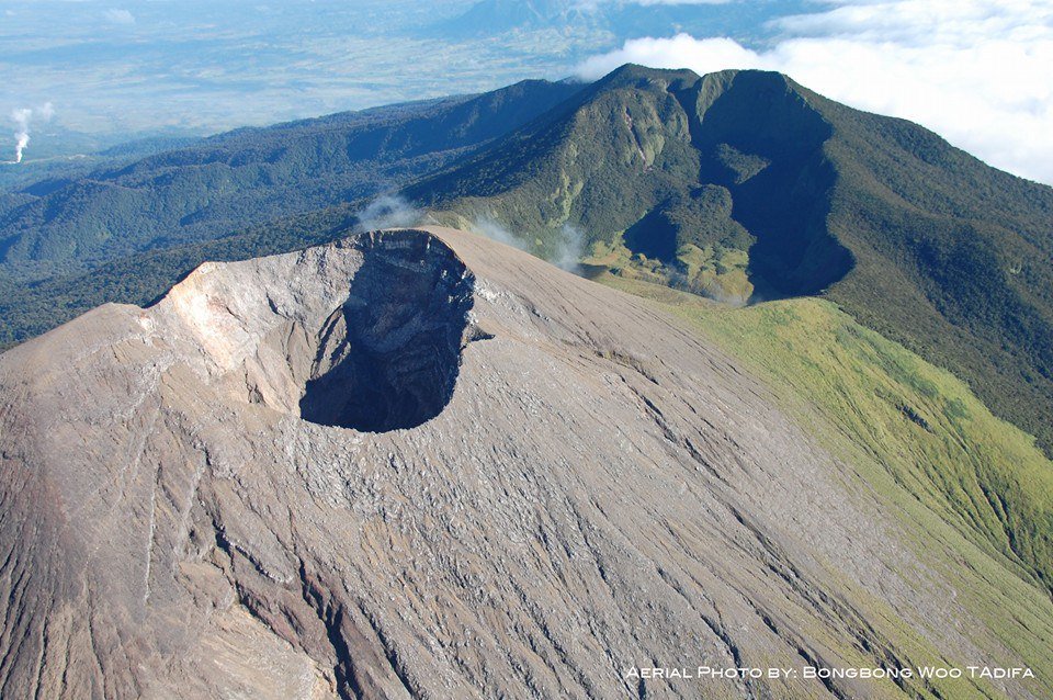
Alert Level 2 status prevails over Kanlaon Volcano, which means that the volcano is undergoing a moderate level of unrest due to probable intrusion of magma at depth that may or may not lead to a magmatic eruption. The local government units and the public are strictly reminded that entry into the 4-kilometer radius Permanent Danger Zone (PDZ) is strictly prohibited due to the further possibilities of sudden and hazardous steam-driven or phreatic eruptions. Civil aviation authorities must also advise pilots to avoid flying close to the volcano’s summit as ejecta from any sudden phreatic eruption can be hazardous to aircraft.
DOST-PHIVOLCS is closely monitoring Kanlaon Volcano’s activity and any new development will be relayed to all concerned.
Source : Phivolcs
Photo : BongBong Woo Tadifa