August 14 , 2021.
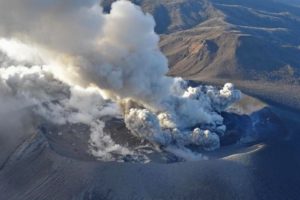
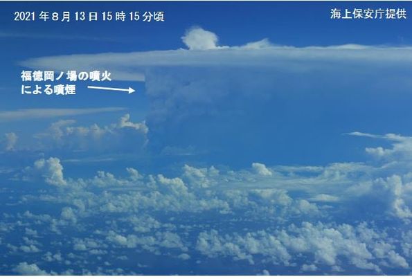
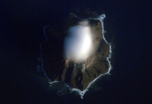
Japan , Fukutoku-Okanoba :
The Japan Meteorological Agency has confirmed that the submarine volcano in Japan’s Ogasawara Islands erupted today (the 13th). This is the first eruption in 11 years. The Japan Meteorological Agency continues to issue volcanic eruption warnings. Taiwan’s meteorological director Zheng Mingdian revealed on Facebook « The smoke has reached the peak of the tropopause. » According to a report by Japan’s « NHK », the Japan Meteorological Agency pointed out that at approximately 6:20 a.m. Japan time on the 13th (approximately 5:20 a.m. Taiwan time on the 13th), a weather satellite captured a photo of the seabed at approximately 50 kilometers south of Iwo Jima, Japan. The « Fukutoku-Okanoba » volcano has erupted. From the satellite image, we can see that white smoke is emerging from the scene, which is constantly drifting west. As a result, the Meteorological Agency issued an eruption warning. In June, the Japanese Coast Guard observed that the surrounding sea surface had changed color, confirming that local volcanic activity had become more active. Zheng Mingdian posted a satellite image of the cloud that has reached the tropopause on Facebook.
Date: August 13, 2021
VAAC: TOKYO
VOLCANO: FUKUTOKU-OKA-NO-BA
PSN: N2417 E14129
ZONE: JAPAN
SUMMIT ALTITUDE: -29 M
NOTICE N °: 2021/4
SOURCE OF INFO: HIMAWARI-8
AVIATION COLOR CODE: NIL
ERUPTION DETAILS: EMISSIONS WILL CONTINUE
Fukutoku-Oka-no-ba is a submarine volcano located 5 km NE of the pyramidal island of Minami-Ioto. Water discoloration is frequently observed from the volcano, and several ephemeral islands have formed in the 20th century. The first of these formed Shin-Ioto (« New Sulfur Island ») in 1904, and the most recent island was formed in 1986. The volcano is part of an elongated edifice with two major topographic highs trending NNW-SSE, and is a trachyandesitic volcano geochemically similar to Ioto.
Sources : news.ltn.com.tw ,VAAC Tokyo , GVP.
Photo : Gardes Côtes Japonais via Sherine France.
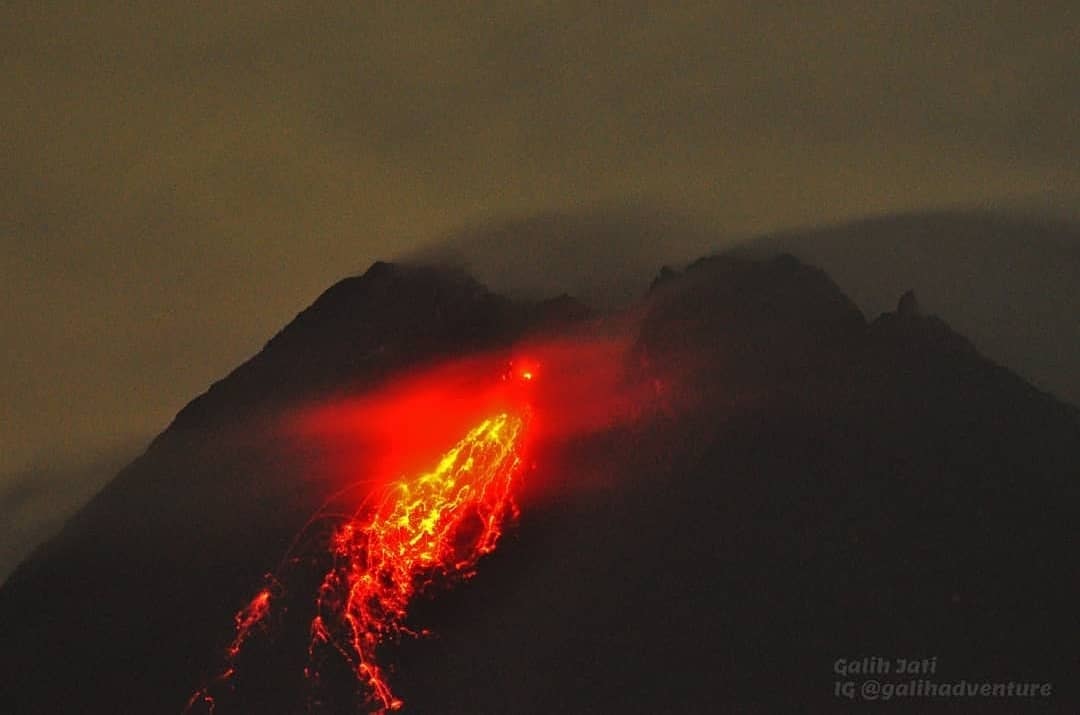
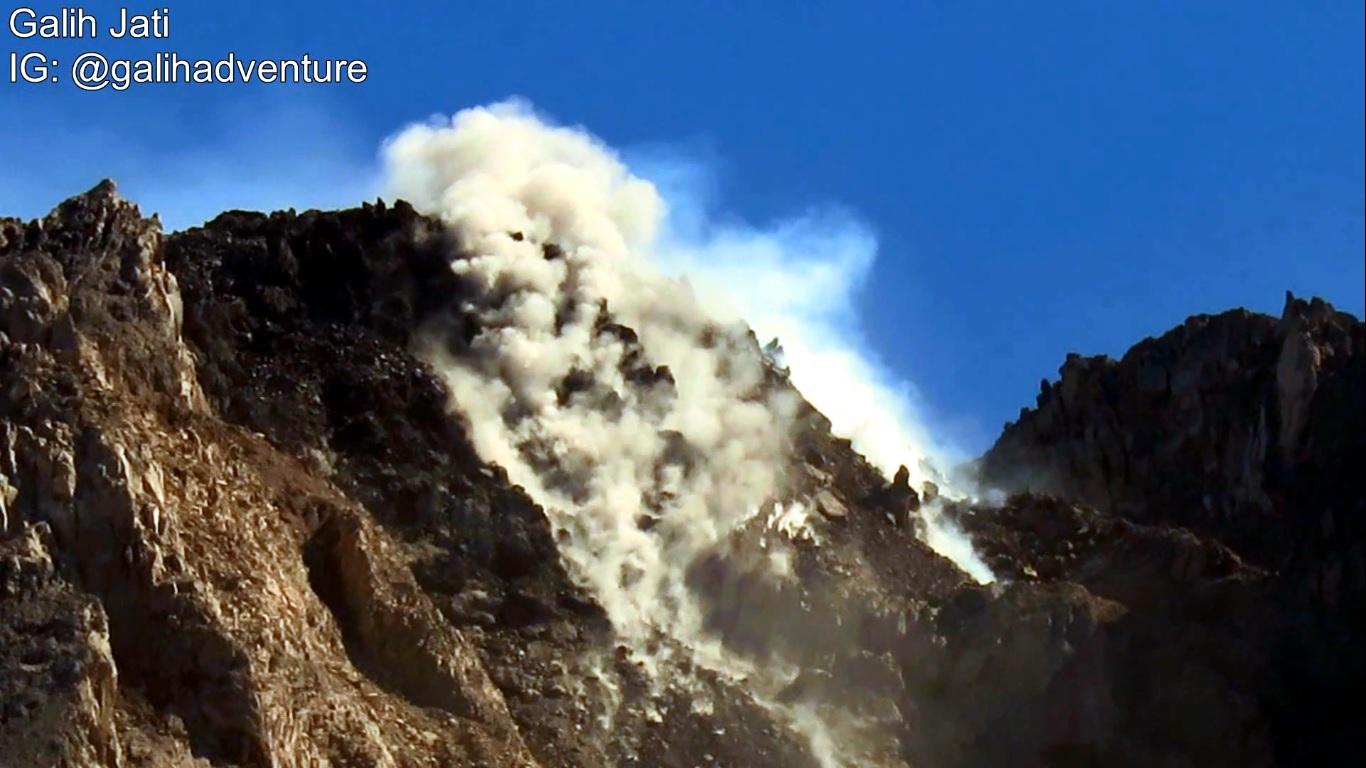
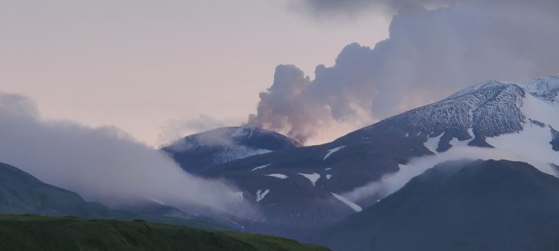
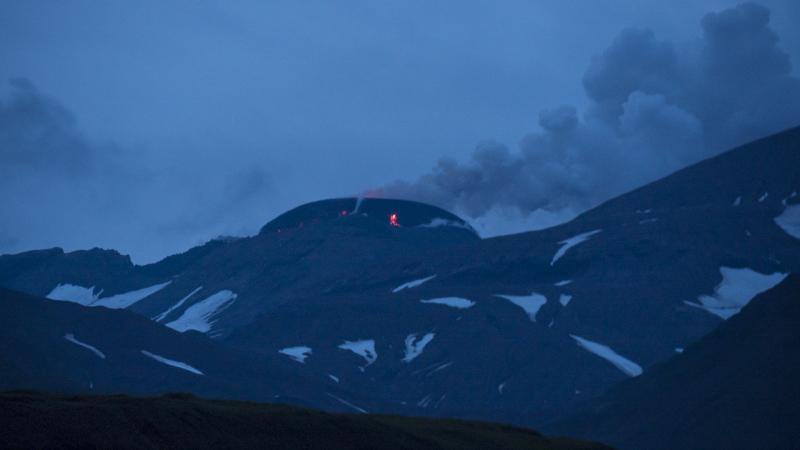
Indonesia , Merapi :
Mount Merapi activity report from August 5 to 12, 2021
OBSERVATION RESULTS
Visual
The weather around Mount Merapi is generally sunny in the morning and evening, while it is foggy in the afternoon. White, weak to thick, low pressure, 600m high fumes were observed from Mount Merapi de Selo observation post on August 7, 2021 at 10:00 a.m. WIB.
This week, there were 28 hot avalanche clouds to the southwest with a maximum slide distance of 3000 m. Lava avalanches were observed 252 times southwest with a maximum slide distance of 2000 m and 1 time southeast with a slide distance of 500 m.
Ash rains were reported in several areas, including August 10-12, 2021, including Dukun, Sawangan, Grabag, Pakis, Tegalrejo, Secang, Srumbung, Salam, Muntilan and Mungkid districts.
It was observed that there were morphological changes in the southwest lava dome and central dome due to increased avalanche activity and hot avalanche clouds this week. The volume of the lava dome is relatively fixed.
Seismicity
This week, the seismicity of Mount Merapi recorded
28 hot cloud avalanche earthquakes (PA),
334 shallow volcanic earthquakes (VTB),
10 low frequency earthquakes (LF),
1,296 multi-phase earthquakes (MP),
2,021 avalanche earthquakes (RF),
141 emission earthquakes (DG),
19 tectonic earthquakes (TT).
The intensity of this week’s earthquake is still quite high.
Deformation
The deformation of Mount Merapi, which was monitored using EDM this week, showed a distance shortening rate of 7.7 cm / day.
Rain and lahars
This week, there have been no reports of rain, lahars or additional flow in the rivers that originate on Mount Merapi.
Conclusion
Based on the results of visual and instrumental observations, it is concluded that:
The volcanic activity of Mount Merapi is still quite high in the form of effusive eruption activity. The status of the activity is defined in the “SIAGA” level.
Source : BPPTKG.
Photos : Yohannes Tyas Galih Jati
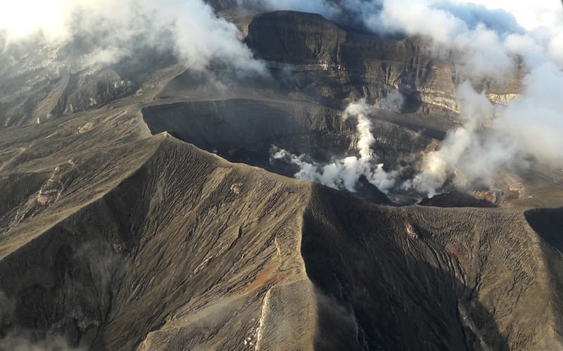
Alaska , Great Sitkin :
52°4’35 » N 176°6’39 » W,
Summit Elevation 5709 ft (1740 m)
Current Volcano Alert Level: WATCH
Current Aviation Color Code: ORANGE
Eruption of a lava dome in the summit crater of Great Sitkin Volcano continued over the last week. Satellite data showed that the dome grew from approximately 300 m diameter on August 6 to around 380 m on August 9. Steam plumes have been visible in satellite and web camera images, but no ash emissions have been detected. Small earthquakes have been detected that are likely associated with the lava effusion. No explosive activity has been detected.
There is no indication of how long lava effusion will continue during the current eruption, and it is possible that explosive activity could occur with little or no warning.
Great Sitkin Volcano is monitored by local seismic and infrasound sensors, satellite data, web cameras, and remote infrasound and lightning networks.
Great Sitkin Volcano is a basaltic andesite volcano that occupies most of the northern half of Great Sitkin Island, a member of the Andreanof Islands group in the central Aleutian Islands. It is located 43 km (26 miles) east of the community of Adak. The volcano is a composite structure consisting of an older dissected volcano and a younger parasitic cone with a 3-km-diameter summit crater. A steep-sided lava dome, emplaced during the most recent significant eruption in 1974, occupies the center of the crater. That eruption produced at least one ash cloud that likely exceeded an altitude of 25,000 ft above sea level. A poorly documented eruption occurred in 1945, also producing a lava dome that was partially destroyed in the 1974 eruption. Within the past 280 years a large explosive eruption produced pyroclastic flows that partially filled the Glacier Creek valley on the southwest flank.
Source : AVO.
Photos : Kruse, Peggy , Ward, Dave .
Kamchatka , Chirinkotan :
VOLCANO OBSERVATORY NOTICE FOR AVIATION (VONA)
Issued: August 14 , 2021
Volcano: Chirinkotan (CAVW #290260)
Current aviation colour code: ORANGE
Previous aviation colour code: orange
Source: KVERT
Notice Number: 2021-88
Volcano Location: N 48 deg 58 min E 153 deg 28 min
Area: Northern Kuriles, Russia
Summit Elevation: 724 m (2374.72 ft)
Volcanic Activity Summary:
The moderate eruptive activity of the volcano continues. The explosive event of the volcano occurred at 02:15 UTC on 14 August. Ash cloud 17×15 km in size is drifting for 13 km to the south-southeast of the volcano.
This activity continues. Ash explosions up to 10-15 km (32,800-49,200 ft) a.s.l. could occur at any time. Ongoing activity could affect international and low-flying aircraft.
Volcanic cloud height:
3000-3500 m (9840-11480 ft) AMSL Time and method of ash plume/cloud height determination: 20210814/0300Z – Himawari-8
Other volcanic cloud information:
Distance of ash plume/cloud of the volcano: 13 km (8 mi)
Direction of drift of ash plume/cloud of the volcano: SSE / azimuth 164 deg
Time and method of ash plume/cloud determination: 20210814/0300Z – Himawari-8
Start time of explosion and how determined: 20210814/0215Z – Satellite data
Source : Kvert .
Saint Vincent , Soufrière Saint Vincent :
La Soufriere Volcano – SCIENTIFIC UPDATE 13/08/21 1:00PM
-Seismic activity at La Soufrière, St Vincent has remained low since the tremor associated with the explosion and ash venting on 22 April. In the last 24 hours, only a few small earthquakes have been recorded.
-Current activity is consistent with a period of unrest after an eruption. This can continue for weeks to months. While volcanic activity has been on a decline, there is the continued presence of near surface hot spots, daily seismic activity and persistent degassing.
– Measurements of the sulphur dioxide (SO2) flux at La Soufrière were carried out by boat off the west coast on 10 August, with the assistance of the coast guard. Several traverses were completed and yielded an average SO2 flux of 205 tons per day.
– There is a small, but not insignificant, possibility that magmatic activity might restart, should there be an influx of new magma from depth.
-The volcano is at alert level ORANGE.
Source et photo : UWI
Ecuador , Reventador :
DAILY REPORT OF THE STATE OF THE REVENTADOR VOLCANO, Friday August 13, 2021.
Information Geophysical Institute – EPN.
Surface activity level: High, Surface trend: No change.
Internal activity level: Moderate, Internal trend: No change.
Seismicity: From August 12, 2021, 11:00 a.m. to August 13, 2021, 11:00 a.m.
There were no interruptions in data transmission. The statistics for the day are complete.
Explosions (EXP): 57 events
Long period type events (LP): 32
Emission tremor (TREMI): 5.
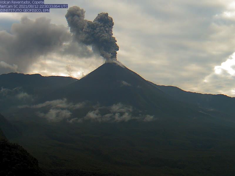
Rains / lahars: There has been no rain in the area for the past 24 hours.
Emission / ash column: In the afternoon of yesterday, ash emissions were observed with directions to the southwest and west, which exceeded 1000 meters above the crater level, this thanks to surveillance cameras. The VAAC published 3 reports of emissions observed from satellites. Their directions ranged from southwest to northwest, with heights of up to 1,000 meters above crater level.
Other monitoring parameters: No thermal anomaly was recorded by the satellites. The other monitoring parameters do not record changes.
Observations: In the afternoon of yesterday, most of the weather was clear, the described emissions were observed and the active lava flow was observed towards the northeast flank. From night until the close of this bulletin, the volcano remained mostly cloudy.
Alert level: Orange.
Source et photo : IG-EPN