May 12 , 2021.
Italy , Stromboli :
Weekly bulletin, from May 03, 2021 to May 09, 2021 (issue date May 11, 2021)
SUMMARY OF THE STATE OF ACTIVITY
In the light of surveillance data, it is highlighted:
1) VOLCANOLOGICAL OBSERVATIONS: Normal explosive volcanic activity of Strombolian type accompanied by sometimes intense projection activity in the N2 zone. The total frequency of events showed values between medium (10 events / h) and medium-high (17 events / h).
The intensity of the explosions varied from low to medium-high in the North crater area and medium-high in the Center-South area.
2) SEISMOLOGY: The monitored seismological parameters do not show significant variations.
3) DEFORMATIONS: The variation of the radial component of the TDF station began on May 2, 2021 and continued during the week, until May 4, 2021.
4) GEOCHEMISTRY: SO2 flow at medium level
The C / S ratio in the plume is at average values, slightly increasing
The isotopic ratio of Helium shows average values.
5) SATELLITE OBSERVATIONS: The thermal activity in the summit area is at a moderate level.
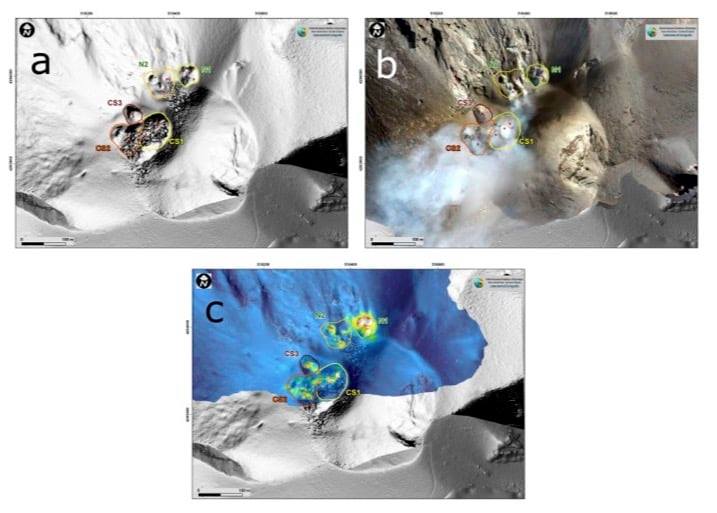
Photo of the area of the Stromboli crater on March 31, taken with a) shaded model of the terrain, the lines of different colors delimit the different areas of the crater; b) orthomosaic, the lines of different colors delimit the different areas of the crater; c) thermal ortho-image superimposed on the shaded terrain model, thermal anomalies are identifiable with white red yellow, cold areas are blue.
VOLCANOLOGICAL OBSERVATIONS
In the period under observation, the eruptive activity of Stromboli was characterized by the analysis of the images recorded by the surveillance cameras INGV-OE located at an altitude of 190 m, Punta Corvi and an altitude of 400 m.
Morpho-structural characterization of the crater area following the inspection of May 8, 2021.
Within the framework of the activities of the UNO project and the DPC / all convention. A, an ortho photo and a DSM (Digital Surface Model) of the crater area with a resolution of 7 and 25 cm, respectively, were processed. Direct on-site observation and morpho-structural analysis of the aforementioned areas made it possible to verify the following evolutions compared to the last morphological update of March 31, 2021 and to assess the state of the active vents:
(1) The area of the N1 crater has widened by 8 m in the southwest direction and has 3 active vents
(2) In the area of the N2 crater, 2 slag cones with a diameter of about 20 m and two other coalescers with a maximum elongation axis of 25 m were formed, where there were previously depressions of crater. It has 4 active mouths.
(3) The CS2 and CS1 crater areas are now merging and there are at least 10 mouths inside, of which 7 are active. The southwest edge widened a few meters in the southwest direction.
(4) The CS3 crater area has remained unchanged and has an inactive vent.
Description of the explosive activity captured by surveillance cameras.
In the area of the North crater, the N1 crater produced explosions of varying intensity from low to medium-high (sometimes the products reached 250 m in height) emitting coarse materials (lapilli and bombs). The N2 vent, at four emission points, showed explosive activity of varying intensity from low to medium-high (sometimes the products reached 250 m in height) emitting mainly coarse materials with a throwing activity that was intense for short intervals on May 6. The average frequency of explosions varied from 8 to 13 events / h.
In the Center-South zone, there were at least three emission points with explosions, emitting coarse and fine materials, with medium and sometimes high intensity (the products exceeded 250 m in height).
The explosive activity showed average hourly frequency values between 1 and 4 events / h.
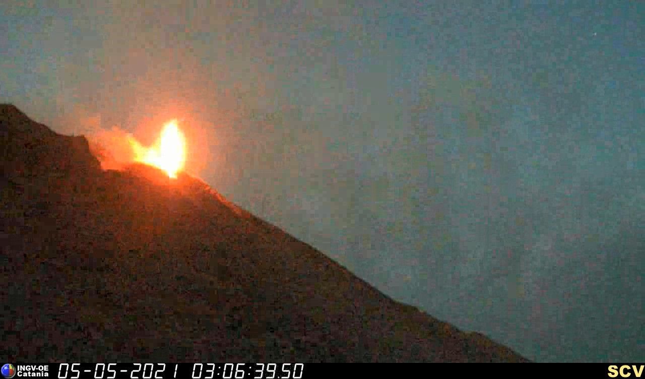
PRESS RELEASE VOLCANIC ACTIVITY – STROMBOLI, May 11, 2021.
From around 08:00 a.m. on May 11, until 11:30 a.m. (UTC time), we observe by surveillance cameras and INGV personnel on the ground, a volcanic activity characterized by an intense activity of projections in the area. from the North crater. In particular, the activity was discontinuous with more intense phases between 8:10 a.m. and 9 a.m. and between 9:45 a.m. and 10:45 a.m., followed by short and more discontinuous phases. The Center-Sud crater sector produced explosive activity of varying and intense intensity. Overall, activity landed at a medium to high level to stay at an average level during the afternoon.

At the same time, from 08:05 hours (UTC time), an increase in the level of tremor of the top stations was observed, which reached medium to high values until 11:30 hours UTC and then returned to the levels. previous ones. The evolution of the VLP signals did not show variations either in number or in amplitude, which remains at low levels.
The available soil deformation data show no significant variation.
Source et photos : INGV.
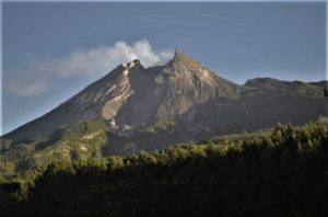
Italy / Sicily , Etna :
Weekly bulletin, from May 03, 2021 to May 09, 2021 (issue date May 11, 2021)
SUMMARY OF THE STATE OF ACTIVITY:
In the light of surveillance data, it is highlighted:
1) VOLCANOLOGICAL OBSERVATIONS: Degassing activity of summit craters and discontinuous Strombolian activity at the Southeast Crater, accompanied by low ash emissions.
2) SEISMOLOGY: significant swarm seismic activity, low level of tremor
3) INFRASOUND: Increase in infrasound activity.
4) DEFORMATIONS: There are no significant variations in the time series of soil deformation monitoring networks.
5) GEOCHEMISTRY: SO2 flow at medium-low level
The CO2 flux from the soil shows average values.
The partial pressure of dissolved CO2 in groundwater reaches background values.
No new data from the C / S ratio is available.
Helium isotopic ratio values remain at high levels, although declining (sampling 04/23/2021).
6) SATELLITE OBSERVATIONS: The thermal activity in the summit area is at a low level.
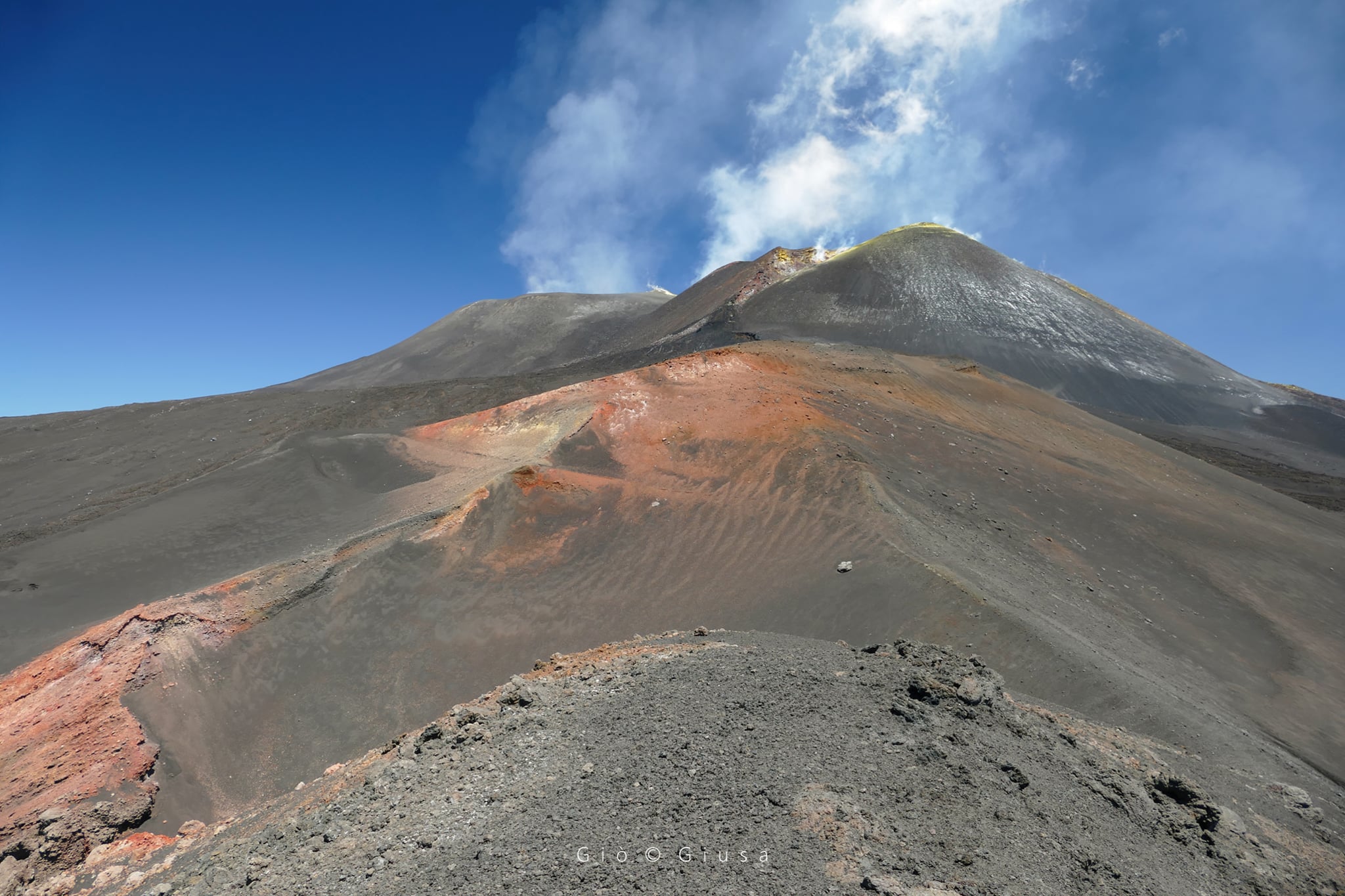
Degassing of the summit of Etna with the central area of the craters (Voragine and Bocca Nuova) on the left and the South-East crater on the right.
VOLCANOLOGICAL OBSERVATIONS
During the week, the monitoring of the volcanic activity at the level of the summit craters of Etna was carried out by analyzing the images of the network of surveillance cameras of the INGV Section of Catania, Etneo Observatory (INGV-OE).
During the week in question, the summit craters were affected by a variable degassing activity associated with a discontinuous Strombolian activity at the level of the Southeast Crater. In particular, intermittent and weak Strombolian activity was observed at the eastern mouth of the Southeast Crater, sometimes accompanied by small puffs of gray-brown ash, immediately dispersed in the summit area.
Volcanic tremor:
The magnitude of the tremor was low. The locations of the sources show a notable dispersion under the central craters and the Southeast Crater. The depths vary between 0.5 and 2.5 km above sea level.
Source : INGV.
Photo: Giò Giusa
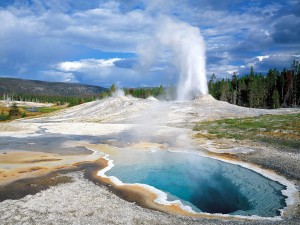
Iceland , Geldingadalur :
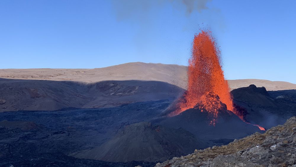
The magma fountains soar 300 meters into the air.
The volcanic projections that rise from the Geldingadalur crater reach a height of 300 meters when the power is at its highest. The crater that was created is now about 50 meters high.
Volcanologist Þorvaldur Þórðarson says the flow rate of the lava flow from Geldingadalur crater is always in the range of 5 to 10 cubic meters per second, and even closer to ten cubic meters. Updated results of lava flow and eruption measurements are expected today.
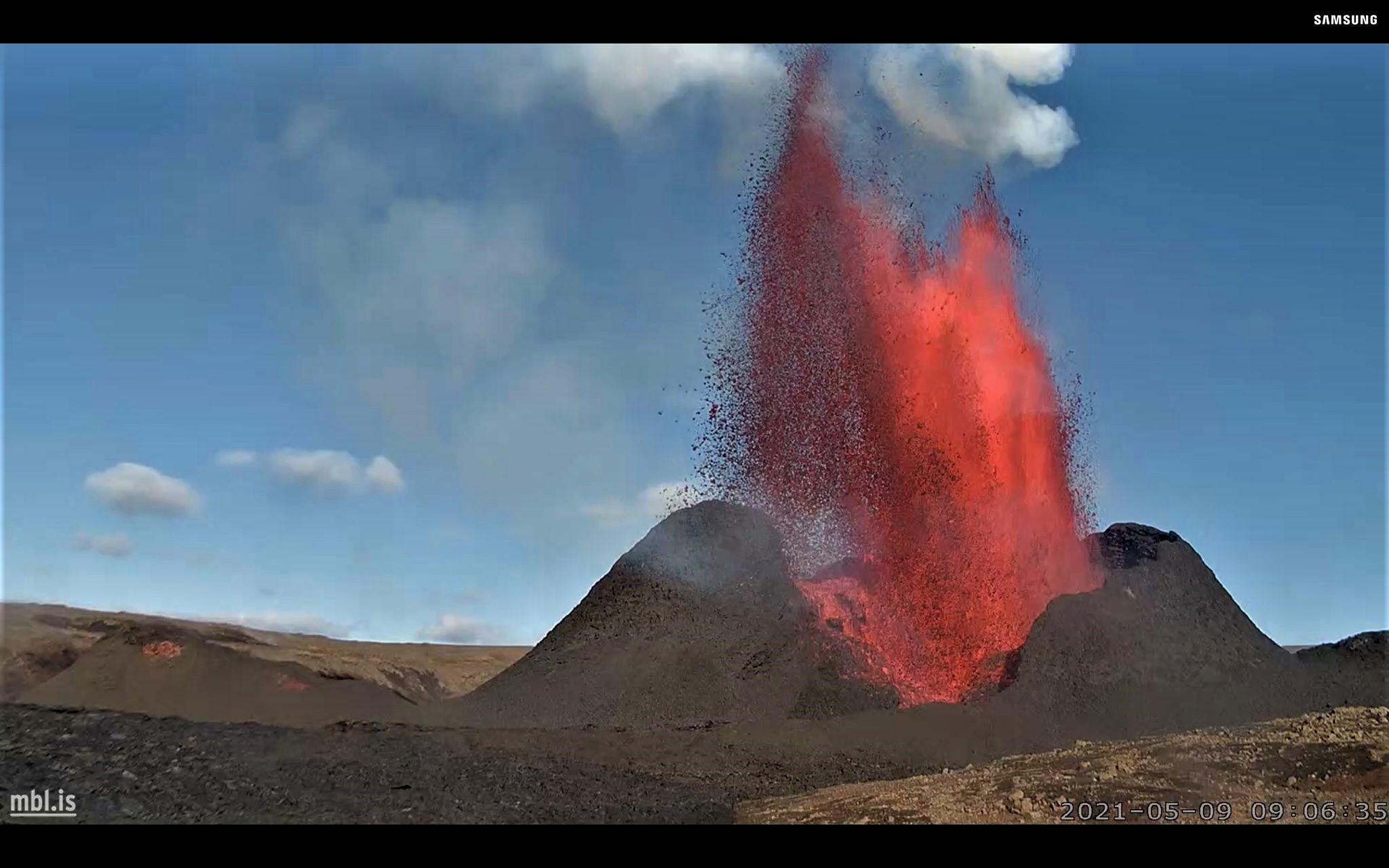
Around 1 p.m. yesterday, Monday, the crater jets were extremely high. They have been seen from many places. For example, they were clearly visible through the window of the Ríkisútvarp news agency in Efstaleit / Reykjavík. They always show up at a steady pace. The eruption seems to have stopped for a few minutes before setting off again in the crater and the magma is projected hundreds of meters into the air. It is an impressive sight, even from miles away.
The erupting volcano on the Reykjanes peninsula continues to surprise earth scientists, nearly two months after it started. According to the latest readings, lava flow is up by 70 percent and the eruption is twice as powerful as it has been for most of the time so far. “For an eruption to be growing in its eighth week is unusual and there are no signs we are about to see that stop. This is a different type of eruption than we are used to seeing,” says geophysicist Magnús Tumi Guðmundsson.
Data show that 95 percent of eruptions are most powerful at the beginning and then lose power gradually or quite suddenly. The eruption close to Fagradalsfjall appears to be an exception to that rule. “A significant increase in lava flow has occurred at Fagradalsfjall in recent weeks,” a press release from the University of Iceland earth sciences department confirms.
The increased lava flow appears to go hand-in-hand with the lava fountais that are being regularly throw high into the sky. The volcano’s new lava field now covers 1.8 square kilometres and has an overall mass of some 30 million cubic metres.
Most eruptions originate from a magma chamber under a central volcano. Pressure and the size of the chamber dictate how long and how big the eruption is. “But this eruption seems to be controlled by the eruption channel and how much it can transport. The channel that opened was particularly narrow and long,” the university report states—adding that the evidence suggests it is widening as time goes on.
Magnús Tumi says the data confirm what many have instinctively felt: that the eruption is getting bigger. It was not certain before, though, as the formerly stable eruption has become more volatile, so it is harder to compare.
Magnús Tumi says it is highly unusual for an eruption to be gaining strength two months in. He says there is no sign the current developments will change, and no way of knowing when the eruption will stop, or for how long it will continue growing in strength.
Source : RUV.
Photo: Hólmfríður Dagný Friðjónsd – RÚV , MBL .
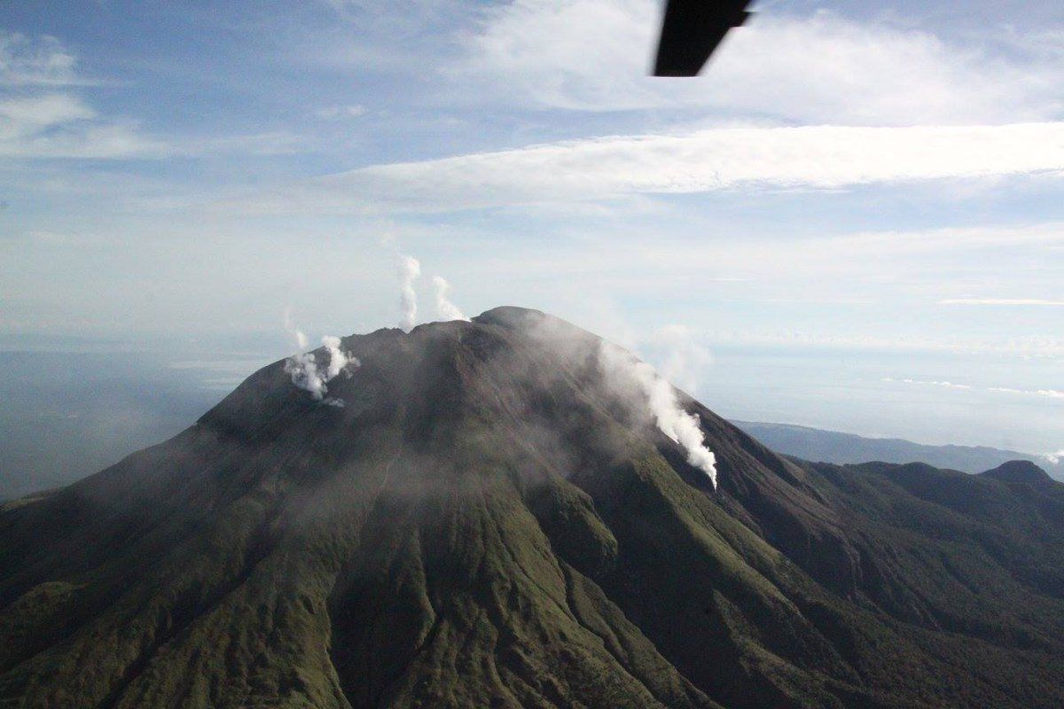
Philippines , Bulusan :
BULUSAN VOLCANO BULLETIN 12 May 2021 08:00 A.M.
In the past 24-hour period, the Bulusan Volcano Network recorded one hundred sixty-six (166) volcanic earthquakes. Ground deformation data from real-time electronic tilt monitoring recorded sustained inflation of the upper slopes that began 6 March 2021 consistent with short-term inflation of the edifice measured by continuous GPS monitoring since February 2021. These parameters generally indicate that shallow hydrothermal processes are occurring beneath the edifice.
Alert Level 1 status now prevails over Bulusan Volcano, which means that it is currently in an abnormal condition. Local government units and the public are reminded that entry into the 4-kilometer radius Permanent Danger Zone (PDZ) must be strictly prohibited and that vigilance in the 2-kilometer Extended Danger Zone (EDZ) on the southeast sector must be exercised due to the increased possibilities of sudden and hazardous phreatic eruptions. Civil aviation authorities must also advise pilots to avoid flying close to the volcano’s summit as ash from any sudden phreatic eruption can be hazardous to aircraft. Furthermore, people living within valleys and along river/stream channels especially on the southeast, southwest and northwest sector of the edifice should be vigilant against sediment-laden stream flows and lahars in the event of heavy and prolonged rainfall should phreatic eruption occur. DOST-PHIVOLCS is closely monitoring Bulusan Volcano’s condition and any new development will be communicated to all concerned stakeholders.
Source et photo : Phivolcs.
Chile , Cerro Hudson :
For the period evaluated, the seismic activity associated with rock fracturing (VT type events), whose locations are around the caldera, shows a slight increase in the quantity and energy of the events compared to the previous period. .
Two higher energy events stand out on April 17 and 23, both with a local magnitude (ML) of 2.9. They were located 4.1 km and 4.2 km, both southwest (SSW) of the center of the caldera with a depth of 4.1 and 1.8 km respectively.
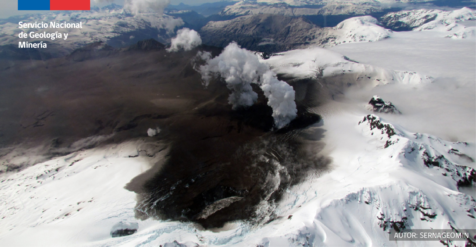
The seismic activity associated with the fluid dynamics inside the volcano (type LP and HB) showed an increase in the number of long-term LP events compared to the previous fortnight, although they showed a decrease energy released. It should be noted that no hybrid earthquake was identified during the period analyzed.
The data provided by the GNSS stations recorded variations of 0.7 cm / month in the station located to the West-North-West of the volcanic building, however this variation would be attributable to seasonal effects.
No abnormal surface activity was recorded for the period evaluated.
Source : Cegemar.
Photo : Sernageomin.