May 03 , 2021 .
La Réunion Island , Piton de la Fournaise :
Press release of May 02, 2021 – 2:15 p.m.
The eruption that started on 04/09/2021 at 7 p.m. (appearance of the tremor) continues. The intensity of the volcanic tremor (indicator of a surface lava emission) stopped its slow decrease and is
relatively stable for three days now.
– Over the past 24 hours, 4 superficial volcano-tectonic earthquakes (between sea level and the surface) have been recorded, all located directly above the summit craters.
– The CO2 fluxes in the soil are always increasing in the far field (Plains region).
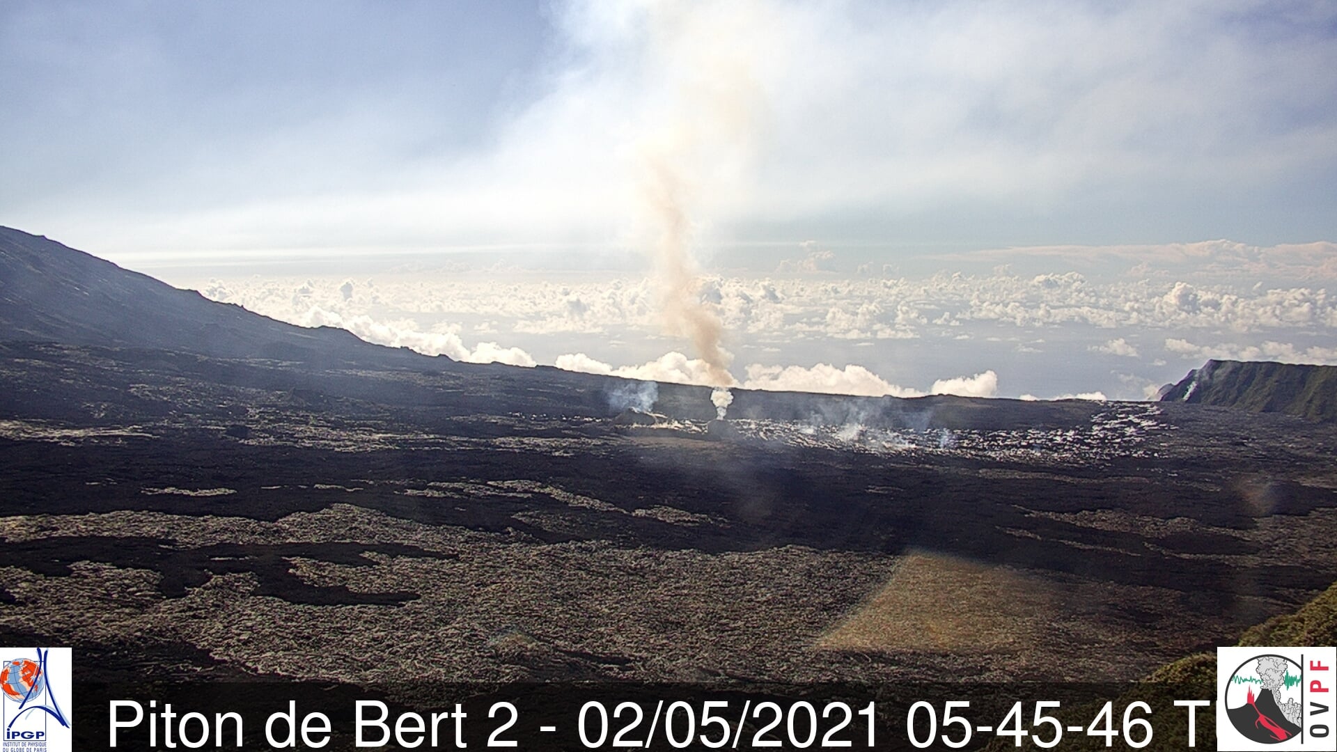
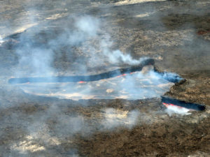
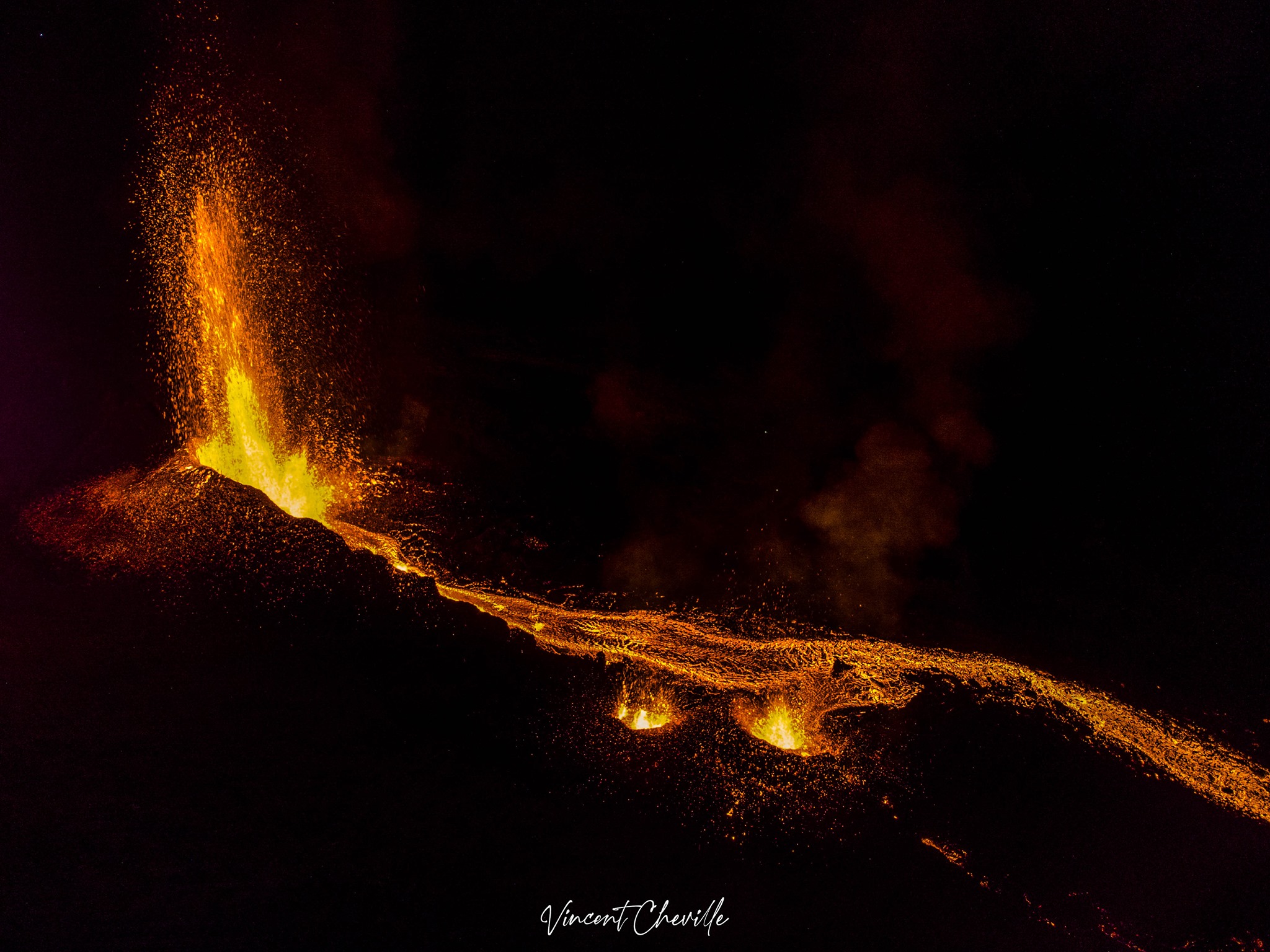
Image of the eruptive site taken this morning at 9.45am local time (5.45am UTC) from the webcams of the OVPF-IPGP-IRT
located at Piton de Bert (© OVPF-IPGP-IRT). We can see a fire at the foot of the nose cut of Tremblet, meeting place
of the flow and the rampart.
– A slight inflation (swelling) of the summit area and the base of the terminal cone seems to be emerging. This parameter will be monitored over the next few days because it may correspond to the pressurization of the superficial magmatic reservoir located under the summit and could suggest a deep magma flow entering the superficial magmatic reservoir greater than the outlet flow of the reservoir which supplies the eruptive site.
– The improvement in weather conditions on site since last night has made it possible to observe the eruption from Piton de Bert and more generally from the rampart on the Enclos Fouqué. On the image below, we can distinguish, the two vents, a more intense plume on the vent located most downstream, the flow from the eruptive site and up to the break in slope, as well as the smoke produced by the fire at the foot of the rampart at the level of the Nez Coupé du Tremblet.
– Improved weather conditions made it possible to estimate the lava flow by satellite imagery. Surface flows estimated from satellite data via the HOTVOLC platform (OPGC – Clermont Auvergne University) remain below 8 m3 / s. However, the lava flow, now largely tunneled, probably leads to an underestimation of this flow.
– Note, since this morning the presence of a fire in the vegetation located at the foot of the Nez coupé du Tremblet.
Alert level: Alert 2-2
Source : OVPF
Read the article : https://www.ipgp.fr/sites/default/files/ovpf_20210502_14h15_communique_eruption.pdf
Photos : OVPF , Vincent Cheville ( https://rando-volcan.com @tunnelsdelavereunion )
United-States , Yellowstone :
44°25’48 » N 110°40’12 » W,
Summit Elevation 9203 ft (2805 m)
Current Volcano Alert Level: NORMAL
Current Aviation Color Code: GREEN
Recent work and news
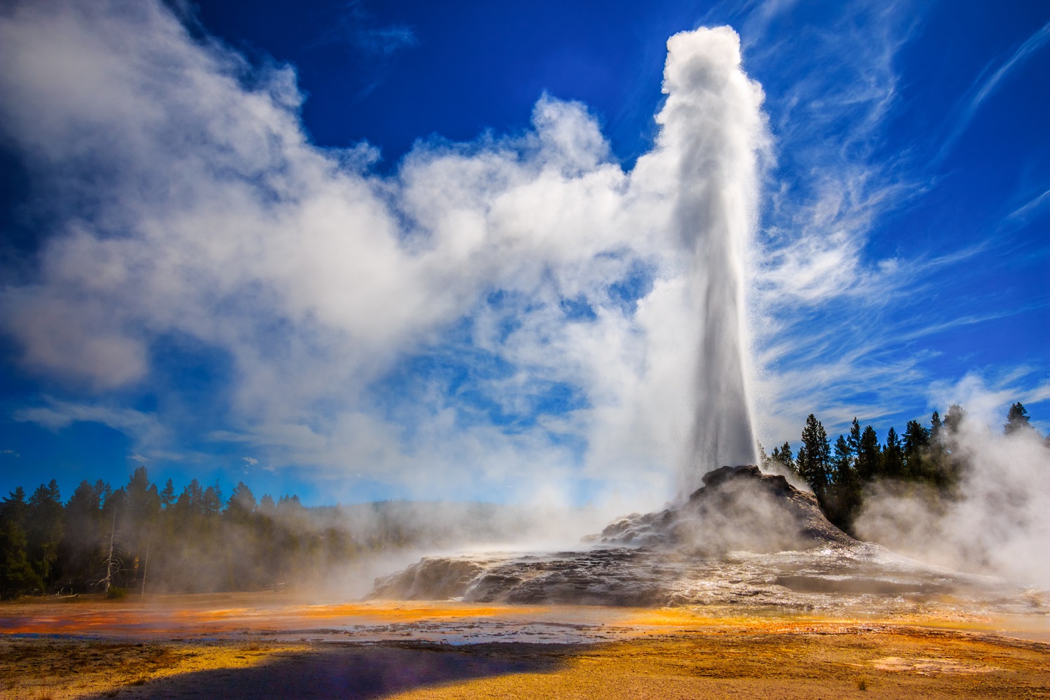
In the past month there were three major water eruptions of Steamboat Geyser, on April 4, 16, and 23. This brings the total number of eruptions for the year to 10.
May marks the start of the field season in Yellowstone, and geologists, geophysicists, and geochemists will begin a variety of field projects in the park this month. Some of the first work will include maintenance of GPS, seismic, and temperature monitoring stations. In addition, starting on May 10 geophysicists will install temporary GPS stations across the Yellowstone region. These stations, which will be recovered in October before the onset of winter, provide a seasonal densification of the Yellowstone ground deformation monitoring network and have been deployed annually for the past 15 years.
Seismicity
During April 2021, the University of Utah Seismograph Stations, responsible for the operation and analysis of the Yellowstone Seismic Network, located 43 earthquakes in the Yellowstone National Park region. The largest event was a minor earthquake of magnitude 2.5 located 15 miles northeast of West Yellowstone, MT, on April 27 at 3:07 AM MDT.
No swarm activity was observed in April.
Yellowstone earthquake activity remains at background levels.
Ground deformation
Deformation rates and styles at Yellowstone, as recorded by continuous GPS stations, have been steady over the past year. Subsidence of Yellowstone Caldera, which has been ongoing since 2015, continued at an average rate of 2-3 cm (about 1 in) per year. In the area of Norris Geyser Basin, no significant uplift or subsidence has been detected by a nearby GPS station since the start of 2020.
Source : YVO.
Photo : USGS.
Saint Vincent , Soufrière Saint Vincent :
La Soufriere, St. Vincent, SCIENTIFIC UPDATE 02/05/21 6:00PM
– Seismic activity at La Soufrière, has remained low since the tremor associated with the explosion and ash venting on 22 April.
– In the last 24 hours, only a few long-period, hybrid and volcano-tectonic earthquakes have been recorded and there was no further seismic tremor.
– The volcano continues to be in a state of unrest.
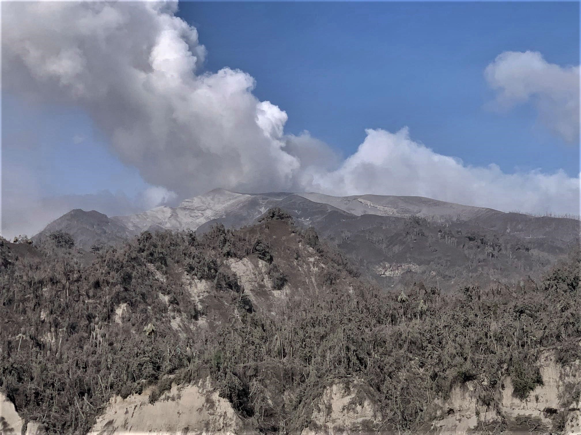
Fieldwork and recon. A zoomed in view of La Soufriere along the northern Leeward coastline as she continues venting
– Explosions with accompanying ashfall, of similar or larger magnitude to those that have already occurred in this eruption, can take place with little or no warning.
– Caution should be taken in traversing river valleys on the volcano due to the increased risk of lahars (mudflows) during periods of rainfall on the volcano.
– The volcano is at alert level RED.
Source : UWI.
Photo : Thomas Christopher, MVO/UWI-SRC.
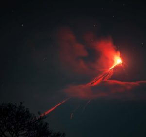
Iceland , Geldingadalur :
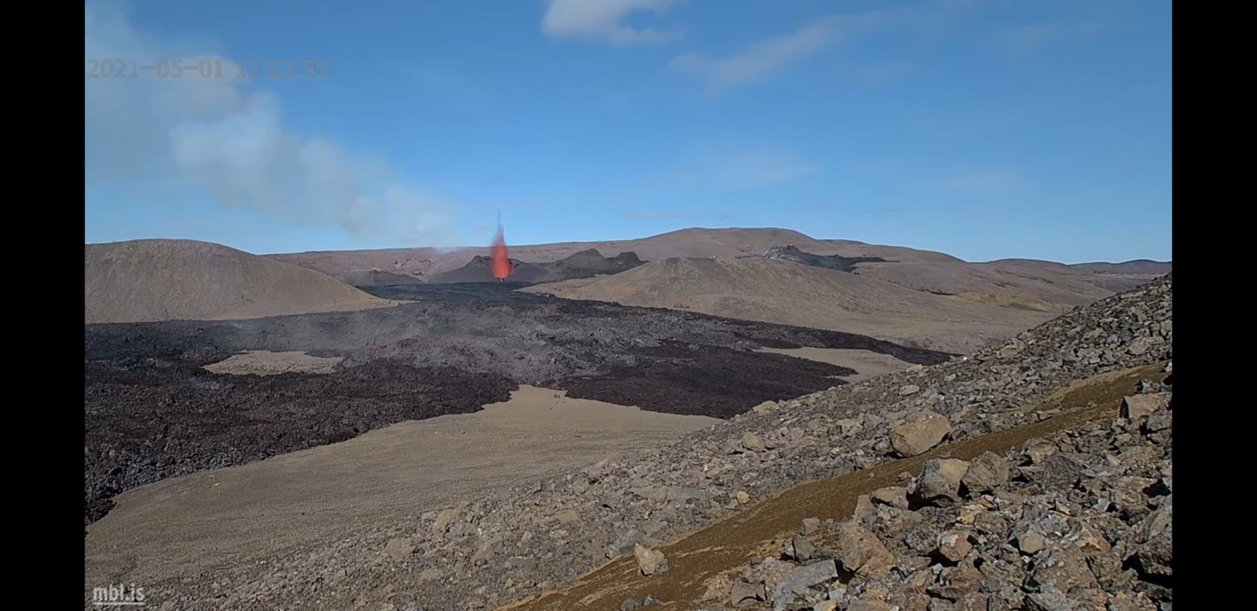
There have been considerable changes in volcanic activity in the most important crater of Geldingadalur. It now emits high jets of magma that are clearly visible from almost the entire southwest area. There was a change in activity last night and since then the eruption has been blowing magma higher into the air than what has been seen before.
Volcanology professor Þorvaldur Þórðarson says at the moment the eruption appears to be much more volatile than before.
“The activity is decreasing and the area of the lava field in the crater seems to decrease with it to some extent. And then the lava flow also decreases a bit, even the lava flow from the crater stops. The eruption then continues with considerable force and forms jets of magma higher than what we have seen before, probably around 300 meters high. They send projections of magma far enough from the crater. Some landed in the vegetation southwest of the crater and started a fire, ”explains Þorvaldur.
It is not clear whether the rash is on the decline or offensive.
“What is happening is that the gas that is released from the magma does not flow with the magma like it has so far, but it seems to come with certain impulses in the system and then relax. . It’s something that delays the upwelling for a while, then the pressure builds up and the eruption manages to get through that blockage and form these big jets of magma that we’re looking at, ”Þorvaldur explains.
He says it’s not possible to tell if a new fracture is opening, but he thinks it’s a fire rather than a new rash.
Source : RUV.
Photo : MBL IS
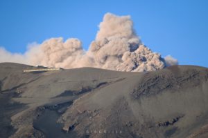
Ecuador , Reventador :
DAILY REPORT OF THE STATE OF THE REVENTADOR VOLCANO, Sunday 02 May 2021.
Information Geophysical Institute – EPN.
Surface activity level: moderate, Surface trend: increasing.
Internal activity level: moderate, Internal trend: No change.
Seismicity: From May 01, 2021, 11: 00h to May 02, 2021, 11: 00h:
Explosions (EXP): 61 events
Long period type events (LP): 86
Emission tremor (TREMI): 6
Harmonic Tremor (TRARM): 2
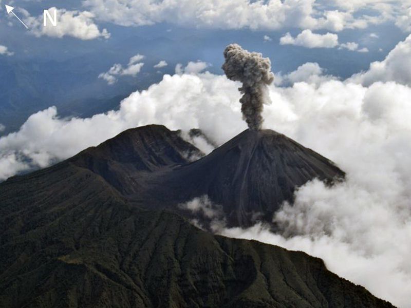
Rains / lahars: Light rains were recorded in the volcano region, which did not generate lahars.
Emission / ash column: Gas and ash emissions were observed up to 1200 meters above crater level, in a northeast and northwest direction. The Washington VAAC reported an emission of gas and ash at 1:38 p.m. in a northwest direction.
Other monitoring parameters: FIRMS has recorded 3 thermal alerts in the last 24 hours.
Observations: The area of the volcano was largely cleared from last night to early morning today. Explosions, incandescence in the crater and rolling blocks have been observed up to 500 meters below the summit on all sides of the volcano. At the moment, the weather is cloudy.
Alert level: Orange.
Source : IGEPN
Photo : F-Naranjo , GVP.