December 22 , 2020.
Hawaii , Kilauea :
Alert Level: WATCH, Color Code: ORANGE 2020-12-21 20:14:01
VOLCANO OBSERVATORY NOTICE FOR AVIATION (VONA)
Issued: December 21 2020
Volcano: Kilauea (VNUM #332010)
Current Color Code: ORANGE
Previous Color Code: RED
Source: Hawaiian Volcano Observatory
Notice Number: 2020/H121
Volcano Location: N 19 deg 25 min W 155 deg 17 min
Area: Hawaii
Summit Elevation: 4091 ft (1247 m)
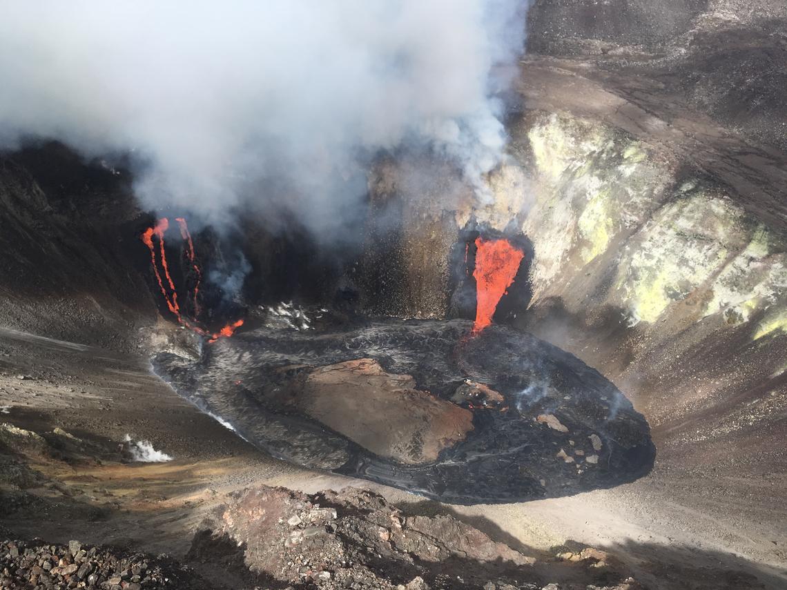
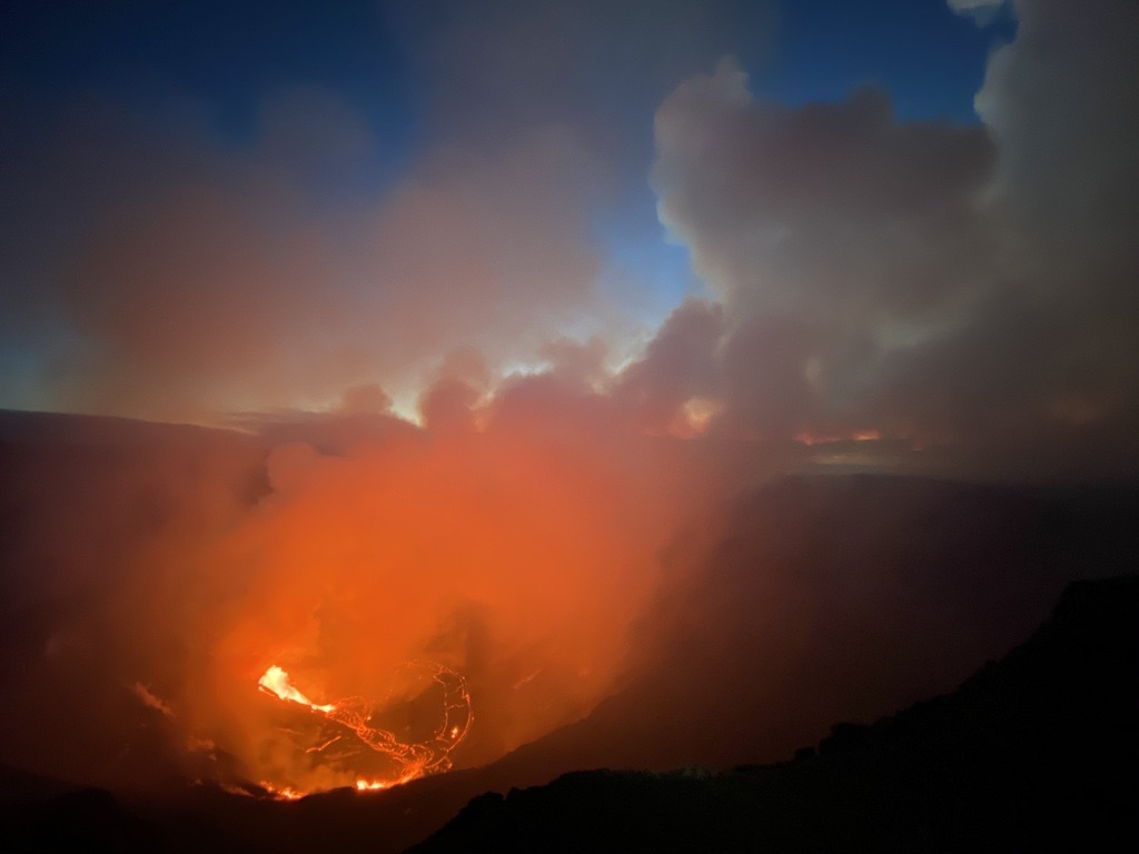
Aerial view of the Kīlauea summit eruption from a Hawaiian Volcano Observatory overflight at approximately 11:20 a.m. HST. The two active fissure locations continue to feed lava into the growing lava lake in Halema‘uma‘u crater, with the northern fissure (pictured right) remaining dominant.
(Credit: M. Patrick, USGS. Public domain.)
Volcanic Activity Summary:
Kīlauea Volcano is erupting. At 9:30 p.m. HST on December 20, the USGS Hawaiian Volcano Observatory (HVO) detected glow within Halemaʻumaʻu crater at the summit of Kīlauea Volcano, indicating that an eruption had commenced within Kīlauea’s summit caldera. Due to the presence of the water lake at the summit of Kīlauea and the potential for steam-driven explosions and related hazards, HVO elevated Kīlauea’s volcano alert level to WARNING and its aviation color code to RED on December 20 as the progression of events was uncertain.
The water lake at the summit of Kīlauea has boiled away and an effusive eruption has commenced, with three vents in the wall of Halemaʻumaʻu crater generating lava flows that are contributing to a growing lava lake at the base of Halemaʻumaʻu crater. The eruption is currently confined to Halemaʻumaʻu crater.
HVO has decreased Kīlauea’s volcano alert level to WATCH and its aviation color code to ORANGE, reflecting the less-hazardous nature of the ongoing eruption.
HVO continues to monitor the volcano closely and will report any significant changes.
HVO is in constant communication with Hawai‘i Volcanoes National Park as this situation evolves. The eruption is currently taking place entirely within the park.
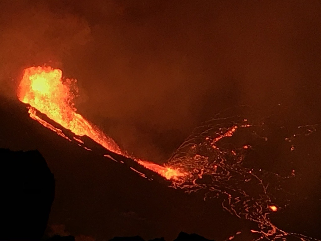
View from the W rim of Kīlauea Caldera just before 5 a.m. HST on Dec. 21, 2020. The main fountain height is ~18 m (59 ft) and with two other fissures feeds a growing lava lake at the base of Halemaʻumaʻu crater. Volcanic gas continues to travel downwind, southwest of the vents.
Recent Observations:
An earthquake swarm beneath Kīlauea summit began around 8:30 p.m. HST on the evening of December 20, accompanied by ground deformation detected by tiltmeters. A bright glow and vigorous steam plume, generated by the boiling water lake in Halemaʻumaʻu, was subsequently observed on HVO webcams beginning approximately 9:30 p.m. HST. HVO scientists responded immediately and visually confirmed from the field that lava was visible within Halemaʻumaʻu. The steam plume dissipated shortly thereafter. Activity over the past ten hours has been characterized by three fissure vents on the north and northwest walls of Halemaʻumaʻu crater. Fountaining lava at these vents is estimated to be up to 25 m (82 ft) high; the vents are feeding lava flows into the base of Halemaʻumaʻu crater, which is being filled with a growing lava lake.
The lava lake has been rising approximately several meters (yards) an hour since the eruption began. The current lava lake exhibits a circulating perimeter, but stagnant center.
The event has been accompanied by only moderate amounts of deformation, indicating deflation of a magma reservoir under Halema’uma’u. Rates of tilting have decreased slightly since the beginning of the eruption.
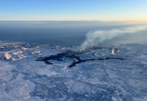
December 21, 2020 – sunrise at the new eruption site in Kīlauea caldera.
Increased rates of seismicity in the summit region continue. Some of these earthquakes may be felt. A magnitude-4.4 earthquake located beneath Kīlauea Volcano’s south flank occurred on Sunday, December 20, at 10:36 p.m. HST.
Visitors to the Hawai’i Volcanoes National Park should note that under southerly (non-trade) wind conditions, rockfalls and explosions can result in a dusting of powdery to gritty ash composed of volcanic glass and rock fragments. These ashfalls represent a minor hazard, but visitors should be aware that dustings of ash at areas around the Kīlauea summit are possible.
Source : HVO.
Photos : USGS , M Patrick
Kamchatka , Sheveluch :
VOLCANO OBSERVATORY NOTICE FOR AVIATION (VONA).
Issued: December 22 , 2020
Volcano: Sheveluch (CAVW #300270)
Current aviation colour code: ORANGE
Previous aviation colour code: red
Source: KVERT
Notice Number: 2020-249
Volcano Location: N 56 deg 38 min E 161 deg 18 min
Area: Kamchatka, Russia
Summit Elevation: 10768.24 ft (3283 m), the dome elevation ~8200 ft (2500 m)
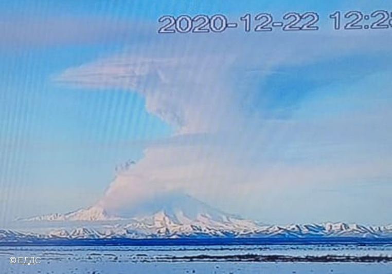
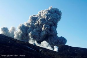
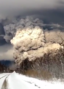
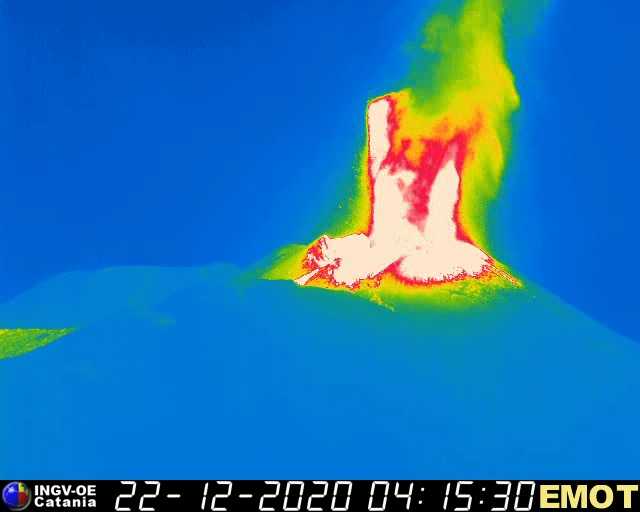
The explosive event of Sheveluch volcano on 22 December, 2020.
Volcanic Activity Summary:
An activity of the volcano continues. Satellite data showed an ash cloud is drifting about 130 km to the east of the volcano.
The extrusive eruption of the volcano continues. Ash explosions up to 32,800-49,200 ft (10-15 km) a.s.l. could occur at any time. Ongoing activity could affect international and low-flying aircraft.
Volcanic cloud height:
21320-24600 ft (6500-7500 m) AMSL Time and method of ash plume/cloud height determination: 20201222/0151Z – MODIS AQUA (31m32)
Other volcanic cloud information:
Distance of ash plume/cloud of the volcano: 81 mi (130 km)
Direction of drift of ash plume/cloud of the volcano: E / azimuth 94 deg
Time and method of ash plume/cloud determination: 20201222/0230Z – Himawari-8
Source : Kvert.
Photo : Kvert / EDDS.
Italy / Sicily , Etna :
ETNA COMMUNICATION [UPDATE n. 105]
The National Institute of Geophysics and Volcanology, Osservatorio Etneo, announces that from 02:50 GMT from the cameras of the visual surveillance network, there is a sharp increase in Strombolian activity affecting at least two mouths of the Southeast crater which, from 03:15 UTC, feeds an overflow of lava from the landslide zone open on the southwest flank of the Southeast crater during the paroxysmal activity of December 13. The lava emission forms a small westward-directed lava flow that overlaps the cooling lava field described in press release no. 103 of December 21, 2020. From the images of the thermal cameras it can also be observed that the lava flow directed towards the Valle del Bove, described in the update no. 104, is no longer powered and cools down.
From the seismic point of view, from 01:30 UTC, we observe a clear increase in the average amplitude of the volcanic tremor, which is located at high values. The position of the center of gravity of the tremor sources is located in the area of the Southeast crater. The infrasound activity is also quite strong, the events are located in the Southeast crater.
At 03:20 UTC, the soil deformation monitoring networks show a slight variation in the inclinometric signals at the summit stations.
ETNA COMMUNICATION [UPDATE n. 106]
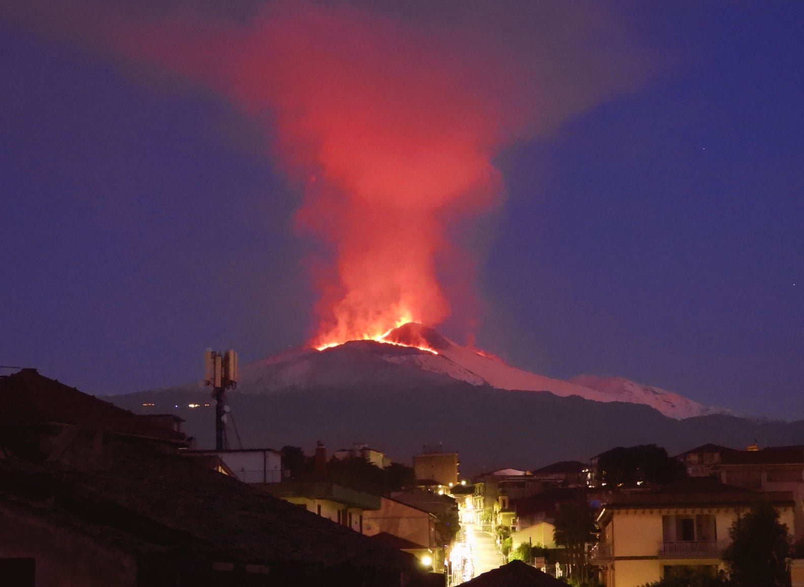
The National Institute of Geophysics and Volcanology, Osservatorio Etneo, announces that from 04:19 UTC the Strombolian activity described in the previous press release n. 104 suddenly evolved into a lava fountain. The activity feeds two distinct lava flows: one heads southwest and splits west and east of Monte Frumento Supino; the second goes east, inside the Valle del Bove.
At present, the mean amplitude value of volcanic tremor remains at a high level. The position of the center of gravity of the tremor sources is located in the area of the Southeast crater. Infrasound activity continues to be sustained, with high values in both frequency of occurrence and amplitude of infrasonic events. The sources of the events are located in the area of the Southeast crater.
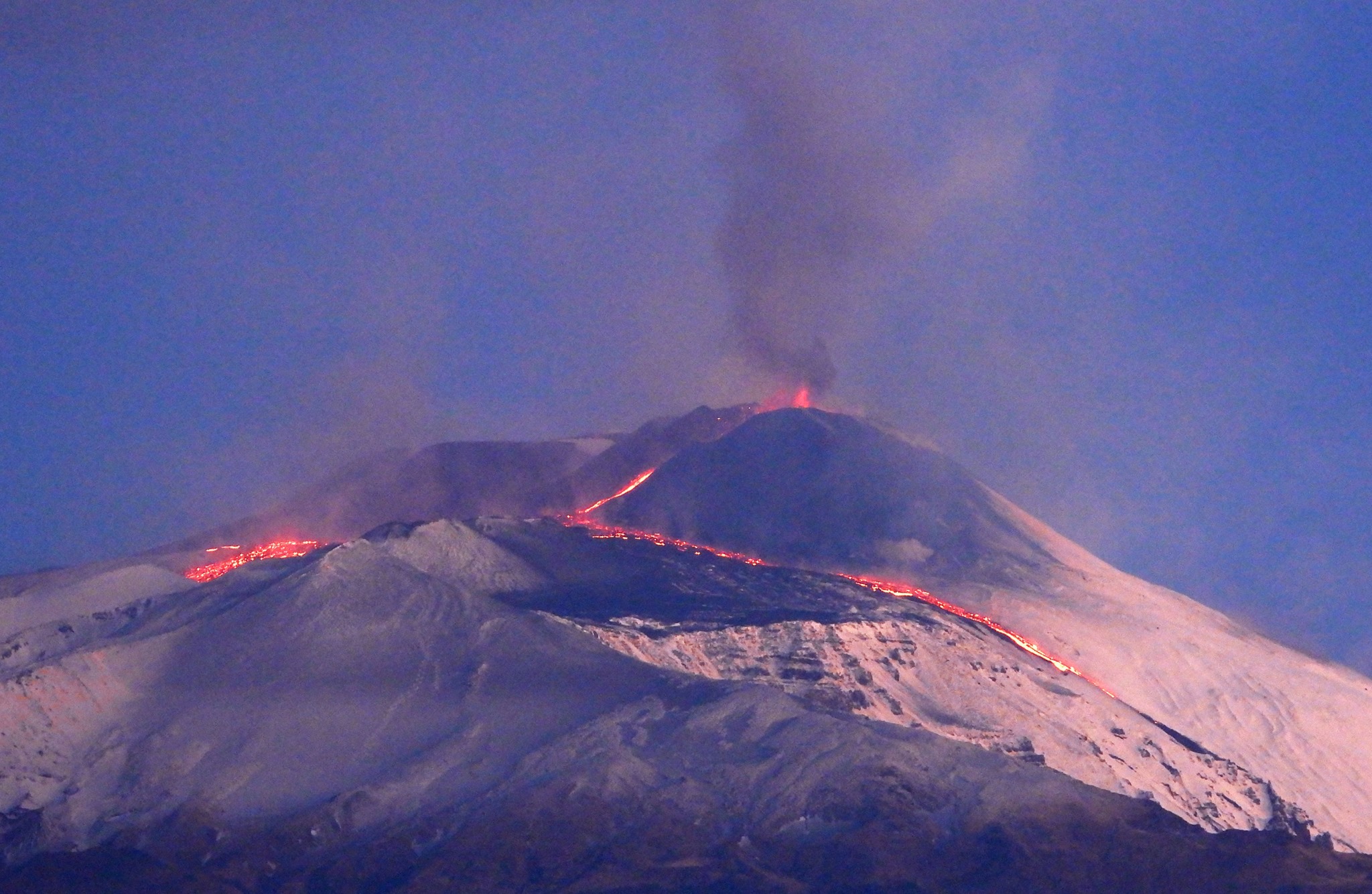
The soil deformation monitoring networks show that the slight variation in inclinometric signals continues at the summit stations. From 04:00 UTC, an even smaller variation is also observable in some stations at medium altitude.
ETNA COMMUNICATION [UPDATE n. 107]
The National Institute of Geophysics and Volcanology, Osservatorio Etneo, announces that from 05:00 UTC, the lava fountain episode described in the previous press release (# 106) gradually diminished until it cease. Among the two previously communicated flows, that of Valle del Bove moves along the western wall of the latter, and the front has reached the estimated altitude of about 2400 m.
In addition, at 04:20 UTC, from the analysis of the images of the surveillance cameras, it was possible to observe a small phreatic explosion in the Valle del Bove, determined by the interaction of the lava flow with the mantle. snowy.
The direct southwest flow is still supplied and the front is located at an altitude estimated at around 2,500 m.
From a seismic point of view, the volcanic tremor showed a clear decrease in its average amplitude from around 04:00 UTC, currently returning to an average value. The position of the centroid of its sources is still located in the area of the Southeast crater. Regarding infrasound activity, it is still sustained and the sources are located mainly in the area of the Southeast crater.
The ground deformation monitoring networks no longer showed significant deformations on the inclinometric signals from approximately 05.45 UTC.
Further updates will be communicated shortly.
Source : INGV
Photos : Boris Behncke . INGV.
Peru , Sabancaya :
Analysis period: December 14 to 20, 2020, Arequipa, December 21, 2020.
Alert level: ORANGE
The Geophysical Institute of Peru (IGP) reports that the eruptive activity of the Sabancaya volcano remains at moderate levels, that is, with the continuous recording of explosions with columns of ash and gas up to 3.3 km altitude above the summit of the volcano and their subsequent dispersion. Therefore, for the following days, no significant change is expected in the eruptive activity.
The IGP recorded and analyzed the occurrence of 877 earthquakes of volcanic origin, associated with the circulation of magmatic fluids inside the Sabancaya volcano. An average of 34 explosions was recorded daily of low to medium intensity. During this period, Volcano-Tectonic (VT) earthquakes were located mainly in the North-East of Sabancaya and presented magnitudes between M1.9 and M3.6. The most representative earthquake (M3.6) was recorded on December 17 at 2:29 p.m. 7 km northeast of Sabancaya and 12 km deep.

The monitoring of the deformation of the volcanic structure using GNSS techniques (processed with fast orbits) does not present any significant anomalies. However, in general, an inflation process has been observed in the south-eastern sector of Sabancaya and in the north sector (Hualca Hualca volcano). Visual surveillance identified columns of gas and ash up to 3.3 km altitude above the summit of the volcano, which were scattered towards the northwest, west, and southwest sectors of Sabancaya. . Ash falls have been reported in Huambo district. Satellite monitoring has identified the presence of 7 thermal anomalies with values between 1 MW and 6 MW, associated with the presence of a lava body on the surface of the volcano’s crater.
RECOMMENDATIONS
• Keep the volcanic alert level in orange.
• Do not approach within a radius of less than 12 km from the crater.
Source : IGP.
Photo : Andina.