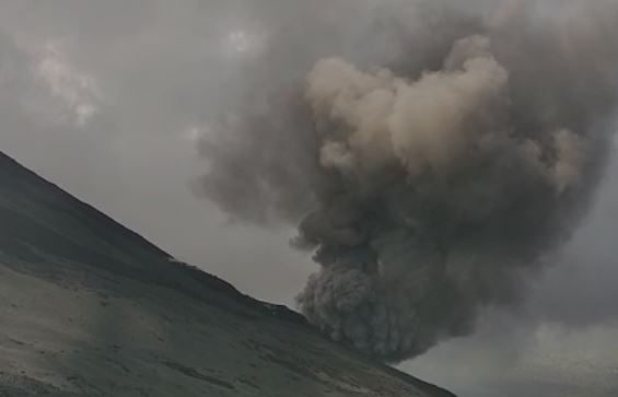
November 16, 2020. EN . Kamchatka : Klyuchevskoy , Guatemala : Pacaya , Indonesia : Merapi , Guadeloupe : La Soufrière .

November 16 , 2020. 


Kamchatka , Klyuchevskoy :

VOLCANO OBSERVATORY NOTICE FOR AVIATION (VONA).

Issued: November 16 ,2020 .
Volcano: Klyuchevskoy (CAVW #300260)
Current aviation colour code: ORANGE
Previous aviation colour code: orange
Source: KVERT
Notice Number: 2020-211
Volcano Location: N 56 deg 3 min E 160 deg 38 min
Area: Kamchatka, Russia
Summit Elevation: 15580 ft (4750 m)

Volcanic Activity Summary:
A moderate explosive-effusive eruption of the volcano continues. According to video and satellite data, gas-steam plume with some amount of ash extended for 105 km to the eastnortheast of the volcano.
This eruption of the volcano continues. Ash explosions up to 19,700-23,000 ft (6-7 km) a.s.l. could occur at any time. Ongoing activity could affect low-flying aircraft.

Volcanic cloud height:
16400 ft (5000 m) AMSL Time and method of ash plume/cloud height determination: 20201116/0500Z – Himawari-8

Other volcanic cloud information:
Distance of ash plume/cloud of the volcano: 65 mi (105 km)
Direction of drift of ash plume/cloud of the volcano: ENE / azimuth 66 deg
Time and method of ash plume/cloud determination: 20201116/0500Z – Himawari-8

Source : Kvert.

Photo : Александр Панферов , 10 novembre, 07:10 


Guatemala , Pacaya :

Information bulletin n ° 504-2020

The scientific entity of the National Coordination System for Disaster Prevention –CONRED-, the Institute of Seismology, Volcanology, Meteorology and Hydrology –INSIVUMEH-, reported through special volcanological bulletins of the increase in the activity of the Pacaya volcano.

INSIVUMEH reports that the Pacaya volcano has increased its effusive activity in recent hours, mainly on the southwest flank. The avalanches increased their course to 500 meters, causing ash to rise. Accompanying this activity, a degassing column is recorded at an altitude of 3000 meters (9843 feet) in white and blue tones.

Likewise, moderate to strong explosions are recorded which reject materials up to 300 meters high above the crater, these explosions launch ballistic projections in a radius of about 100 meters.

Given the increase in the activity of the Pacaya volcano, the Volcano Prevention Unit -UPV-, of CONRED, continues with the verification of the conditions in the communities surrounding the volcano, when it is covered with cloudiness, there is therefore no visibility. Constant communication is maintained with the authorities of the local and municipal coordinators.

It is recommended that the population be attentive to the information shared by their local authorities, as well as have their Family Response Plan, a 72 hour backpack for each family member and promote the principle of self-evacuation, in case they feel their life is in danger.

Source : Conred.

Photo : Prensa libre depuis vidéo.


Indonesia , Merapi :


16 Novembre 2020. FR. Kamchatka : Klyuchevskoy , Guatemala : Pacaya , Indonésie : Merapi , Guadeloupe : La Soufrière .

16 Novembre 2020. 


Kamchatka , Klyuchevskoy :

AVIS D’OBSERVATION DU VOLCAN POUR L’AVIATION (VONA).

Diffusion: 16 novembre 2020.
Volcan: Klyuchevskoy (CAVW # 300260)
Code couleur actuel de l’aviation: ORANGE
Code couleur de l’aviation précédent: orange
Source: KVERT
Numéro de l’avis: 2020-211
Emplacement du volcan: N 56 degrés 3 min E 160 degrés 38 min
Région: Kamchatka, Russie
Altitude du sommet: 15580 pi (4750 m).

Résumé de l’activité volcanique:
Une éruption explosive-effusive modérée du volcan se poursuit. Selon les données vidéo et satellite, un panache de gaz-vapeur avec une certaine quantité de cendres s’est étendu sur 105 km à l’Est-Nord-Est du volcan.
Cette éruption du volcan se poursuit. Des explosions de cendres jusqu’à 19.700-23.000 pieds (6-7 km) d’altitude. pourraient survenir à tout moment. L’ activité en cours pourrait affecter les aéronefs volant à basse altitude.

Hauteur des nuages ​​volcaniques:
16400 ft (5000 m) AMSL Heure et méthode de détermination du panache de cendres / de la hauteur des nuages: 20201116 / 0500Z – Himawari-8

Autres informations sur les nuages ​​volcaniques:
Distance du panache de cendres / nuage du volcan: 105 km
Direction de la dérive du panache de cendres / nuage du volcan: ENE / azimut 66 deg
Heure et méthode de détermination du panache de cendres / nuage: 20201116 / 0500Z – Himawari-8.

Source : Kvert.

Photo : Александр Панферов , 10 novembre, 07:10 


Guatemala , Pacaya :

Bulletin informatif n ° 504-2020

L’entité scientifique du Système national de coordination pour la prévention des catastrophes –CONRED-, l’Institut de sismologie, de volcanologie, de météorologie et d’hydrologie –INSIVUMEH-, a rendu compte par le biais de bulletins volcanologiques spéciaux de l’augmentation de l’activité du volcan Pacaya .

L’INSIVUMEH rapporte que le volcan Pacaya a augmenté son activité effusive ces dernières heures, principalement sur le flanc Sud-Ouest. Les avalanches ont augmenté leur course à 500 mètres, générant un soulèvement des cendres. Accompagnant cette activité, une colonne de dégazage est enregistrée à 3000 mètres d’altitude (9843 pieds) dans les tons blancs et bleus.

De même, des explosions modérées à fortes sont enregistrées qui rejettent des matériaux jusqu’à 300 mètres de haut au-dessus du cratère, ces explosions lancent des projections balistiques dans un rayon d’environ 100 mètres .

Compte tenu de l’augmentation de l’activité du volcan Pacaya, l’Unité de prévention du volcan -UPV-, de CONRED, continue avec la vérification des conditions dans les communautés entourant le volcan, au moment où celui est couvert de nébulosité, il n’y a donc pas visibilité. Une communication constante est maintenue avec les autorités des coordinateurs locaux et municipaux.

Il est recommandé à la population d’être attentive aux informations partagées par leurs autorités locales, ainsi que d’avoir leur Plan de Réponse Familiale, un sac à dos de 72 heures pour chaque membre de la famille et de promouvoir le principe de l’auto-évacuation, au cas où elles sentiraient que leur vie est en danger.

Source : Conred.

Photo : Prensa libre depuis vidéo.


Indonésie , Merapi :