June 27 , 2020.
Ecuador , Sangay :
OVERVIEW OF SANGAY VOLCANO.
Thanks to the management provided by the National Risk and Emergency Management Service (SNGRE), the staff of the Geophysical Institute of the National Polytechnic School (IGEPN) was able to benefit from logistical support from Army Aviation Group No. 45 of Pichincha and the crew of the Ecuadorian army, to conduct an overflight of the Sangay volcano on June 24, 2020 (Fig. 1).
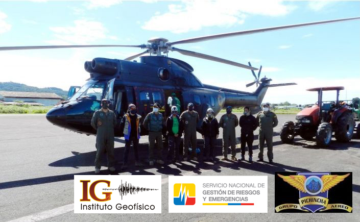
Figure 1. Ecuadorian army air group personnel next to the Super Puma AS332 aircraft, commanded by army major Francisco Andrade. With them, the technical staff of the Geophysical Institute: Dra Silvia Vallejo, Ing. Marco Almeida, Ing. Iván Tapa, Ing. Jéssica Mejía, in charge of volcanic monitoring and maintenance of the SAGA station located near the volcano.
The objective of the mission was to carry out various works related to the volcanic monitoring of the Sangay, which is in a new eruptive phase since May 2019. Among these works there were: the maintenance of the seismic and gas measurement station, surface activity control, thermography and measurement of volcanic gases.
Thanks to this overview, valuable data has been obtained which will help in the study and control of the current surface activity of the volcano (Fig. 2).
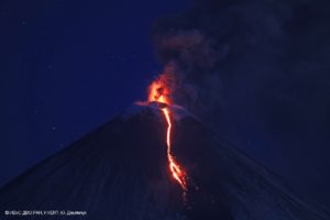
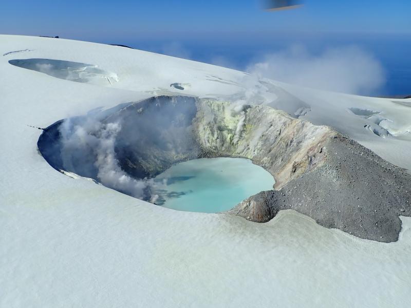
Figure 2. Photograph of the visible and infrared range of the surface activity of the Sangay volcano, a small explosion with a high ash content is observed, which has reached a maximum of 500 meters above the summit of the volcano and disperses in the West, at the same time when a small pyroclastic current is observed descending through the valley eroded by the current activity of the volcano. Photo: M Almeida, IR Image: S Vallejo – IG EPN.
Source : IGEPN /MA, SVV.
Institut géophysique
École polytechnique nationale.
Alaska , Makushin :
53°53’24 » N 166°55’30 » W,
Summit Elevation 5906 ft (1800 m)
Current Volcano Alert Level: ADVISORY
Current Aviation Color Code: YELLOW
Small earthquakes were detected throughout the week centered 12 km southeast of the summit and continuing from a sequence that began on June 16, 2020. The frequency and size of earthquakes have both generally decreased over the week, although minor fluctuations in the overall trend have occurred. No signs of unusual activity have been noted at the surface, apart from typical steaming from the summit crater lake.
This earthquake sequence may be associated with volcanic unrest, but there have been no signs of deformation or surface activity noted in other monitoring data. It is likely that we would see additional signs of unrest prior to an eruption, should it occur. The volcano is monitored with a network of seismic and GPS instruments, a web camera, satellite data, and regional infrasound and lightning detection instruments.
August 2019 views of the summit crater of Makushin Volcano. Heat from vigorous fumarolic activity is melting depressions, holes, and caves in the glacial ice. A low plume of sulfurous volcanic gases drifts off to the NNE.
If an eruption were to occur, the main hazard would likely be from airborne ash and ash fall.
Makushin Volcano is located on northern Unalaska Island in the eastern Aleutian Islands. Makushin is a broad, ice-capped stratovolcano that rises to an elevation of 5906 feet (1800 m). The 1.86-mile-diameter (3 km) summit crater is the site of frequent steam and minor ash eruptions. Three large explosive eruptions occurred at Makushin between 6,000-9,000 years ago, depositing volcanic material many meters thick near the volcano, and several centimeters deep in the community of Unalaska and the port of Dutch Harbor, 16 miles (25 km) east of the volcano. The volcano is monitored with a network of seismic instruments, web camera, GPS, satellite data, and regional infrasound and lightning detection instruments.
Source : AVO.
Photo : Kaufman, Max.
Iceland , Seismic swarm :
The earthquake swarm NE of Siglufjörður is still ongoing. Today at 04:52, June 27 an M4.0 earthquake was detected about 35km NNE of Siglufjordur. Then at 06:02 an M3.2 earthquake was measured abour 20km NE of Siglufjorður. Yesterday more than 700 earthquakes were automatically detected in the area. At 13:55 yesterday an earthquake of M3,2 occurred about 30 km NNE of Siglufjordur.
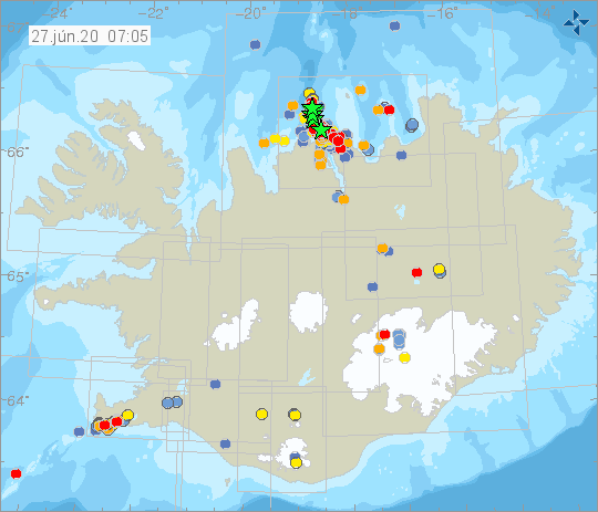
The earthquake swarm began on 19th of June. Around 7000 earthquakes have been detected, three of which measured greater than magnitude 5. The largest was on Sunday at 19:07 of M5.8 around 30 km NNE of Siglufjörður. Other earthquakes above M5.0 were M5.6 and M5.4 and were located around 20 km NE of Siglufjörður.
Seismic activity if still ongoing and there are chances of more earthquakes of this magnitude occurring in the area.
Source : Vedur Is .
Indonesia , Merapi :
Activity report of the Merapi volcano, June 19-25, 2020
OBSERVATION RESULTS
Visual
The weather around Mount Merapi is generally sunny in the morning and at night, while the day until evening is foggy. There is a white smoke, from thin to thick with a low pressure. A maximum smoke height of 600 m was observed from the Mount Merapi observation post in Kaliurang on June 25, 2020 at 9:30 a.m.
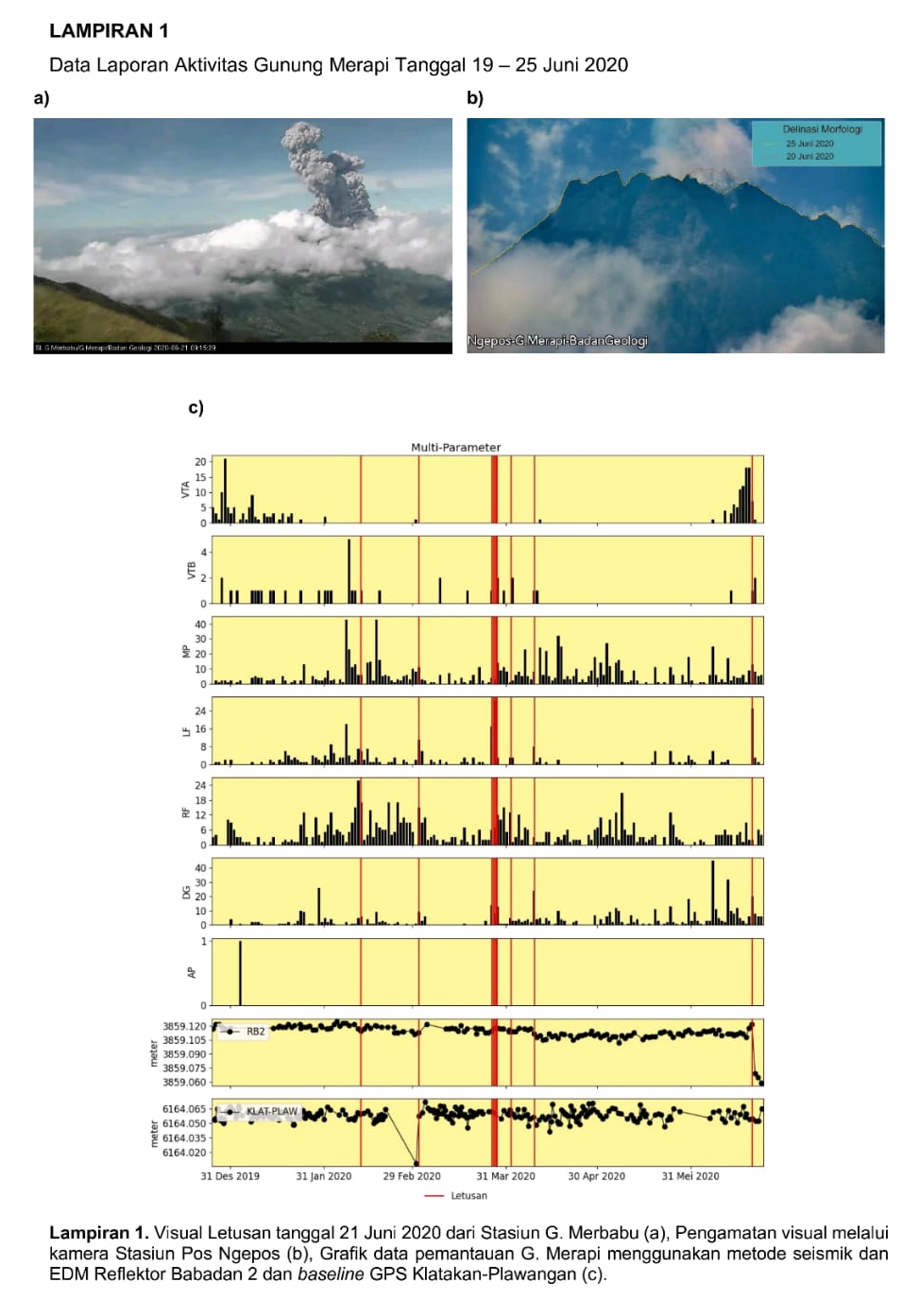
On June 21, 2020 at 9:13 am western Indonesia time and 9:27 am western Indonesia time, an explosive eruption was recorded on the seismogram with an amplitude of 75 mm and a duration of 328 seconds and 100 seconds. From the CCTV Sta. Merbabu, it has been observed to have an eruption column height of ± 6,000 m from the summit. The wind direction was west when the eruption occurred.
After the eruption of June 21, 2020, the morphology of the peak changed slightly. According to a photographic analysis by the Ngepos Post, the southwest sector of the crater cliff in 1997 was eroded by approximately 19,000 m3. For the moment, morphological changes in the crater have not changed the direction of the main threat to the South-South-East. Annex 1.b shows the morphological analysis of the crater through photos of the Ngepos Pos station on June 25, 2020. The volume of the lava dome based on measurements using aerial photographs with drones on June 13, 2020 were of 200,000 m3.
Seismicity:
2 eruption earthquakes
50 emission earthquakes (DG),
45 volcanic earthquakes (VTA),
3 shallow volcanic earthquakes (VTB),
59 multiple phase earthquakes (MP),
29 low frequency (LF) earthquakes,
26 avalanche earthquake (RF),
14 tectonic earthquakes (TT).
The intensity of the seismicity this week is higher than last week.

Deformation:
The deformation of G. Merapi monitored by EDM this week shows a shortening of the clearance distance by ± 7 cm.
Rain and lahars:
There was no rain or lahars reported this week, nor additional flow in the rivers that descend from Mount Merapi.
Conclusion:
Based on the results of the visual and instrumental observations, it was concluded that:
1. The lava dome is currently in a stable state.
2. The volcanic activity of Mount Merapi is still quite high and is stipulated in the activity level « WASPADA ».
Source : BPPTKG.
Photos : BPPTKG, Live frekom.
Mexico : Popocatepetl :
June 26, 11:00 a.m. (June 26, 4:00 p.m. GMT)
In the past 24 hours, the Popocatépetl volcano monitoring system has identified 114 exhalations accompanied by volcanic gases and sometimes small amounts of ash. In addition, 9 minutes of low and medium amplitude tremors were recorded.
At the time of this report, there is visibility on the volcano, any emission of water vapor, gas and ash will disperse to the north.
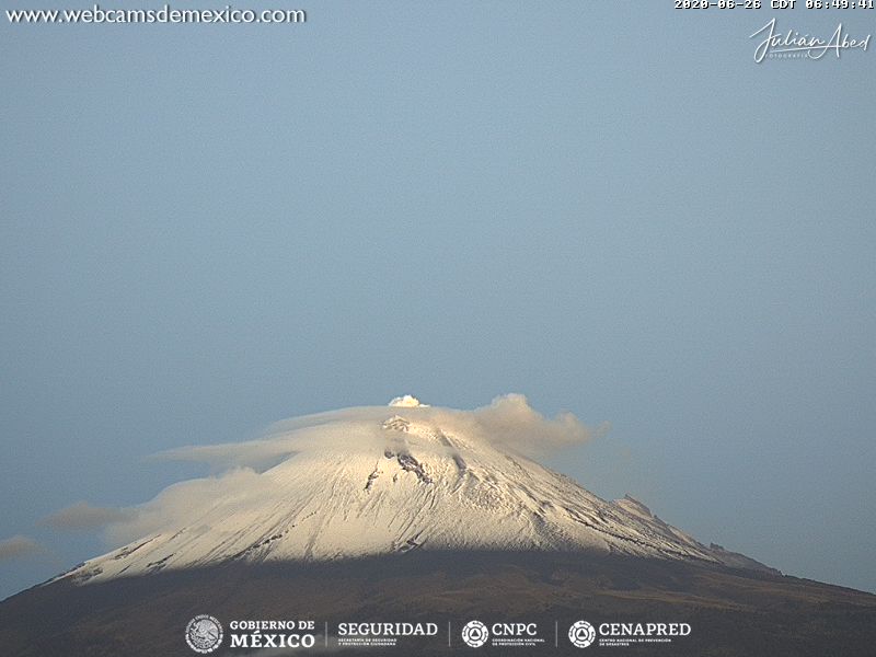
On Saturday June 13, with the support of the National Guard, expert staff from the Geophysical Institute of the National Autonomous University of Mexico (UNAM) and the National Center for Disaster Reduction (CENAPRED), an overview of the Popocatépetl volcano been made to check its general conditions. It has been visualized that the internal crater maintains a diameter of 350 to 380 meters and an approximate depth of 100 to 150 meters, which is covered with tephra. In the background, remains of material from a dome that could have been destroyed during the month of May were observed.
Any change in the activity of the volcano will be reported in due course. CENAPRED urges NOT to get close to the volcano and especially the crater, because of the danger involved in the fall of ballistic fragments and, in the event of heavy rain, to move away from the bottom of the ravines because of the danger of mud and debris.
The Popocatépetl volcanic alert signaling light is in YELLOW PHASE 2.
Source : Cenapred .