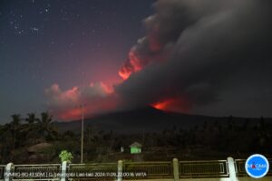
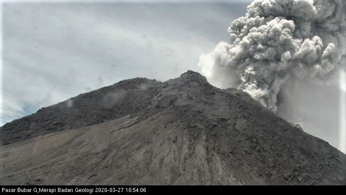
March 27 , 2020 .
Indonesia , Merapi :
VOLCANO OBSERVATORY NOTICE FOR AVIATION – VONA.
Issued: March 27 , 2020 .
Volcano: Merapi (263250)
Current Aviation Colour Code: RED
Previous Aviation Colour Code: green
Source: Merapi Volcano Observatory
Notice Number: 2020MER05
Volcano Location: S 07 deg 32 min 31 sec E 110 deg 26 min 31 sec
Area: Special Region of Yogyakarta, Indonesia
Summit Elevation: 9498 FT (2968 M)
Volcanic Activity Summary:
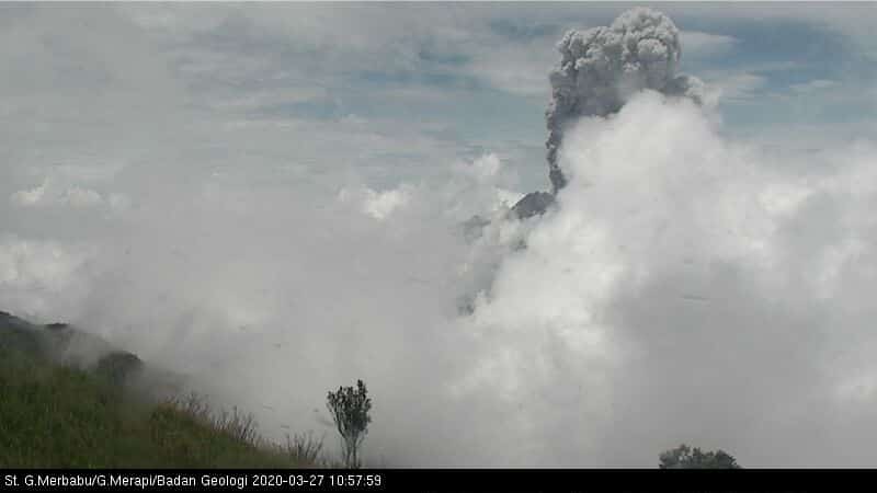
Eruption with volcanic ash cloud at 03h56 UTC (10h56 local). The eruption lasted for 420 seconds
Volcanic Cloud Height:
Best estimate of ash-cloud top is around 25498 FT (7968 M) above sea level, may be higher than what can be observed clearly. Source of height data: ground observer.
Other Volcanic Cloud Information:
Ash-cloud moving to southwest
Remarks:
Eruption recorded on the seismogram with amplitude max 75 mm and 420 second duration. Eruption has stopped.
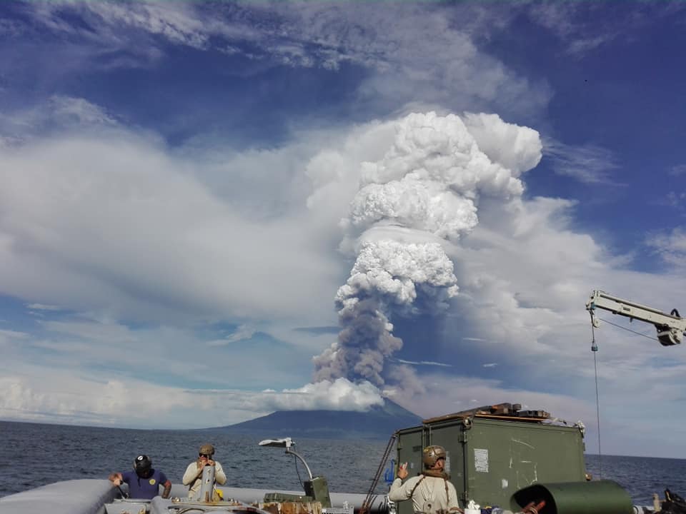
Press release on the Merapi volcano eruption on March 27, 2020
Today, March 27, 2020 at 10:56 a.m. EDT, an eruption is observed with a column height of 5 km from the summit of Mount Merapi. The eruption was recorded on a seismograph with an amplitude of 75 mm and a duration of 7 minutes. It is estimated that the hot Avalanches reach up to 2 km in the South-South-East sector. A VONA message (Volcano Observatory Notice for Aviation) is published with a red color code. The wind during the eruption was oriented to the southwest. Ash rains were reportedly reported within 20 km of the summit, particularly in the western sector reaching the Mungkid sub-district in the Magelang regency. Rains of ash mixed with fine sand have been reported in the area of Banyubiru village, Dukun district, Magelang regency, about 15 km from the summit of Mount Merapi.
The eruption was not preceded by clear warning signs. The seismicity of March 26, 2020 consisted of 2 MP earthquakes and 1 RF earthquake. Likewise, the deformation did not show any significant changes. These observational data indicate that as the eruption approached, there was not enough pressure because the eruption column was dominated by volcanic gas.
This type of eruption can still occur and indicates that the supply of magma to the magma chamber is still in progress. The danger of this type of eruption comes in the form of hot clouds and volcanic materials with a range <3 km based on the volume of the dome of 291,000 m3 based on the drone data of February 19, 2020.
Communities must remain calm and do their activities as usual outside the 3 km radius around the summit of Mount Merapi.
Source : Magma Indonésie , Hanik Humaida / Responsable BPPTKG
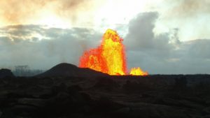
Hawaii , Mauna Loa :
19°28’30 » N 155°36’29 » W,
Summit Elevation 13681 ft (4170 m)
Current Volcano Alert Level: ADVISORY
Current Aviation Color Code: YELLOW
Activity Summary:
Mauna Loa Volcano is not erupting. Rates of deformation and seismicity have not changed significantly over the past week and remain above long-term background levels.
Observations:
During the past week, HVO seismometers recorded around 42 small-magnitude earthquakes beneath the volcano’s upper elevations. Most of these events occurred at shallow depths of less than 5 kilometers (~3 miles) below ground level. There were no events on Mauna Loa above magnitude 2.0.

The 1940 cone, just above the center pierces the relatively flat floor of the Moku’aweoweo caldera, at the top of Mauna Loa, Mauna Kea is visible in the distance.
Global Positioning System (GPS) measurements show continued slow summit inflation, consistent with magma supply to the volcano’s shallow storage system.
Gas concentrations at the Sulphur Cone monitoring site on the Southwest Rift Zone remain stable. Fumarole temperatures as measured at both Sulphur Cone and the summit have not changed significantly.
Source : HVO.
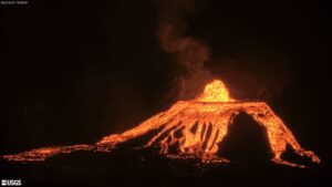
Costa Rica , Turrialba / Poas / Rincon de la Vieja :
Weekly bulletin from the volcanic monitoring program, March 23, 2020.
Turrialba volcano
Lat: 10.025 ° N; Long: 83,767 ° W;
Height: 3340 m above sea level
Current activity level: 2 (active volcano)
Potentially associated hazards: gas, ash emission, proximal ballistic projections.
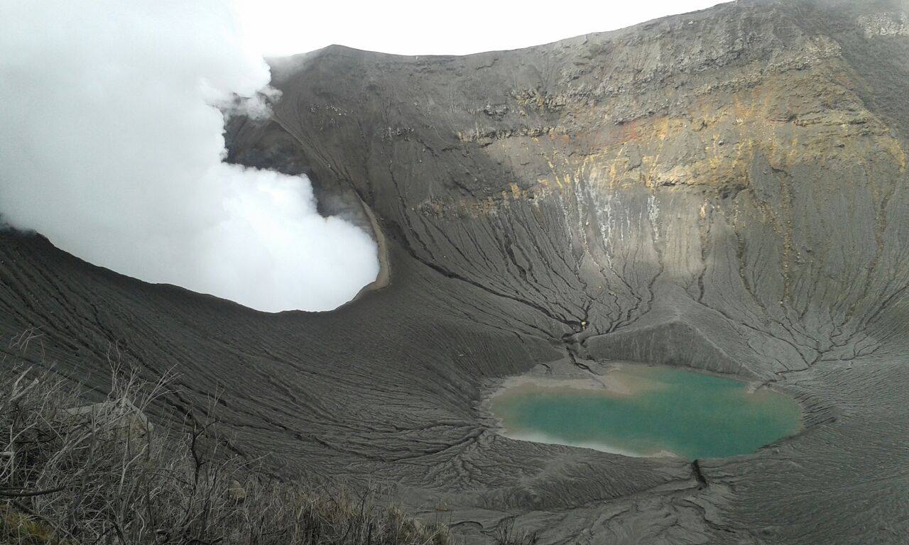
No ash emission was detected. Seismicity is stable with less than 100 daily events. In general, the volcano-tectonic seismicity is dispersed throughout the Turrialba-Irazú massif, and the signal is of low amplitude. The deformation is not significant, it continues with a tendency to shrink. The CO 2 / SO 2 and H 2 S / SO 2 gas ratios show a slight increasing tendency. The flow of SO 2 remains stable and low (<300 t / d).
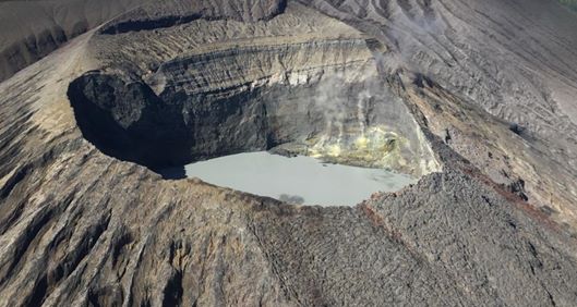
Poás Volcano
Lat: 10.2 ° N; Long: 84 233 ° W;
Height: 2780 m above sea level
Current activity level: 3 (active volcano)
Potentially associated hazards: gas, ash emission, phreatic eruptions, proximal ballistic projections.
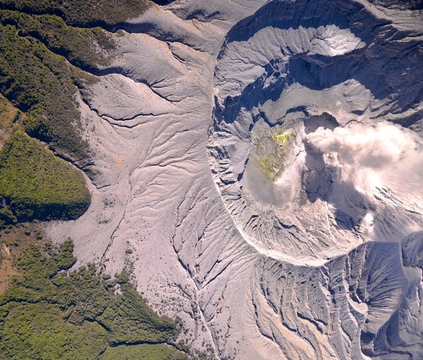
Seismic activity maintains a pattern of variations in the number of LPs. Short regular tremors (without infrasound signal) were recorded for two days, which disappeared on March 22. Inflation and expansion are still recorded but less significant compared to the period from January to February. The SO 2 / CO 2 ratio continues with a general tendency to increase slowly but not yet reaching a critical value (~ 2.0). The H 2 S / SO 2 ratio has been very low since the beginning of March. The flow of SO 2 remains stable with a slight downward trend (around 100 t / d). The concentration of SO 2 at the level from the point of view of the national park did not exceed 5 ppm. The level of the lake continues to drop but slowly.
Rincon de la Vieja volcano
Lat: 10.83 ° N; Long: 85.324 ° W;
Height: 1895 m above sea level
Current activity level: 3 (erupting volcano)
Potentially associated hazards: gas, phreatic eruptions, proximal ballistic projections, lahars.
Small eruptions were detected on March 17, 19, 21 and 23. They were not large enough to generate lahars. Some low amplitude VT and LP type events have been recorded. An extension and a trend towards inflation are still observed but less pronounced than in February. The rapid increase in redox potential of a hot spring in the northern zone reported last week has diminished.
Source : Ovsicori .
Photos : RSN , Federico Chavarría Kopper , Chris Allen de Sunquest Helitours .
Papua New Guinea , Manam :
Activity stirs again at PNG’s Manam volcano , 5:10 pm today .
Another eruption has been recorded at Papua New Guinea’s Manam volcano.
The Volcanic Ash Advisory Center in Darwin reported an explosion at Manam that generated an ash plume reaching approximately 3000 metres high.
Manam, a volcanic island located 12km off New Guinea’s north coast, last erupted in November last year.
A series of eruptions over the past 15 years has forced many people from the island to mainland PNG.
Displaced Manam Islanders continue to struggle for resettlement on the mainland.
Source : rnz.co.nz.
Photo : Jhay Mawengu ( 2018) .
Guatemala , Santiaguito :
Activity type: Pelean
Morphology: Complex of dacitic domes
Location: 14 ° 44 ’33 ˝ Latitude N; 91 ° 34’13˝ Longitude W.
Height: 2500 m above sea level.
Weather conditions Cloudy
Wind: southeast
Precipitation: 0.0 mm.
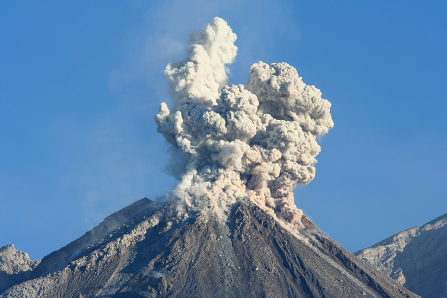
Activity:
A white fumarole is observed in the crater of the Caliente dome, mainly composed of water vapor at an altitude of 2900 m above sea level (9514 feet). The STG3 seismic station records explosions, mainly accompanied by ash at an altitude of about 3,500 meters above sea level (11,483 feet), moving 1.5 km south and southwest of the Caliente dome. Some explosions generate airplane turbine noises due to the pressure of magmatic gases. On the South-East and South-West flanks, the activity generated by the avalanches of boulders continues in the South-West direction of the Caliente dome.
Source : Insivumeh.
Photo : Auteur Inconnu.