August 24 , 2018.
Italy / Sicily , Etna :
Etna is not on vacation: the eruptive activity of the summit increases in intensity. by Marco Neri.
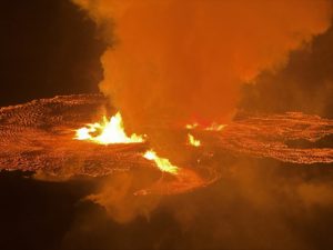
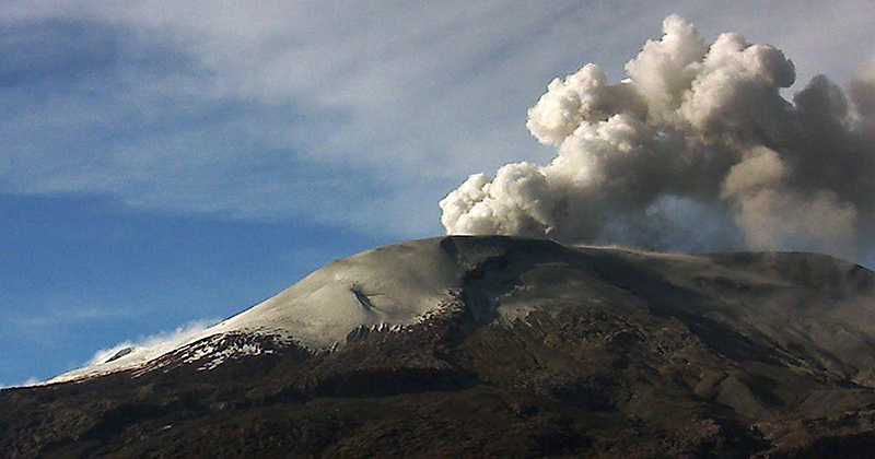
The gradual intensification of eruptive phenomena affecting the summit of Mount Etna continues. In the crater of Bocca Nuova, the Strombolian activity of the BN-1 mouth is more and more relevant (Figure 1). In addition, in the south-eastern part of Bocca Nuova, on August 16, we saw the opening of the BN-2 mouth (figure 1), which had been inactive since December 2015, that is to say from from the moment the Central Crater was completely obstructed by lava flows from the Voragine crater (Figure 2b) through vigorous and spectacular lava fountains.
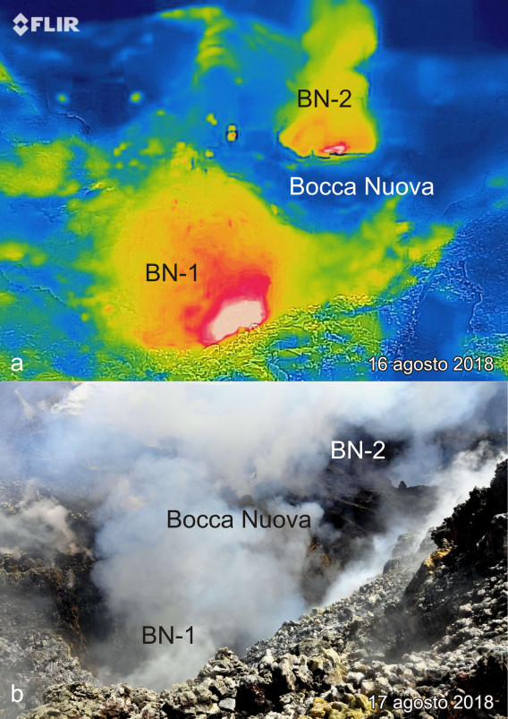
Figure 1 – Etna summit area, Bocca Nuova. Photo above (a): thermal image of August 16, 2018 showing the bottom of the crater of Bocca Nuova. The incandescent areas are highlighted by colors ranging from yellow to red and white. In the foreground, the mouth BN-1 (reactivated in November 2016) and in the background, the mouth BN-2, reopened precisely on August 16 in the Southeast sector of the Nuova Bocca. Resumption of Francesco Ciancitto. Photo below (b): visible image of August 17, 2018, which occupies the same area of the Bocca Nuova. Photo of Marco Neri.
The mouth of the BN-2 is infamous for the disappearance of the Spanish tourist Calde Vill Beatriz Lebena, accidentally precipitated in May 2001 and whose body was never found because of the dense gaseous exhalations and the instability of the overhanging walls BN-2 (see Figure 2a). This new mouth produces intense degassing with high temperatures alternating with Strombolian activity which for the moment remains confined to the crater.
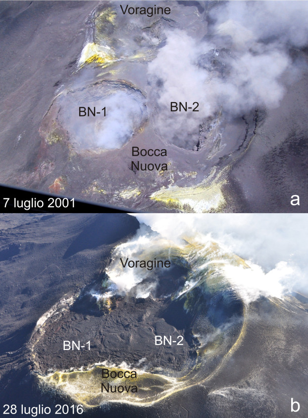
Figure 2 – Bocca Nuova and Voragine craters from Etna taken by helicopter respectively in 2001 (a) and in 2016 (b). The depressions of the existing crater BN-1 and BN-2 inside the Bocca Nuova in 2001 were completely submerged by the lava that was emitted during the eruptions of December 2015 and May 2016. Since November 2016, the the Bocca Nuova underwent subsidence process to reconstitute, on August 16, 2018, the two eruptive mouths BN-1 and BN-2. Photo of Marco Neri.
Even the Northeast Crater, compared to the last weeks, has dramatically increased the violence of its explosive Strombolian activity. Indeed, the explosions pour shreds of incandescent lava at a few tens of meters high on the edge of the crater and the eruptive material sometimes falls outside the crater, spreading mainly near its edge (Figure 3).
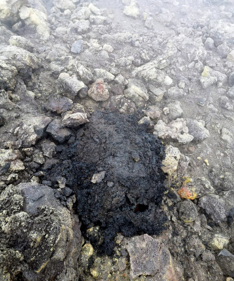
Figure 3 – Etna. This volcanic bomb was probably expelled on August 18, 2018 from the Northeast crater and fell to its southern boundary. Photo of Vincenzo Greco.
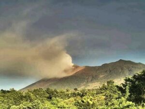
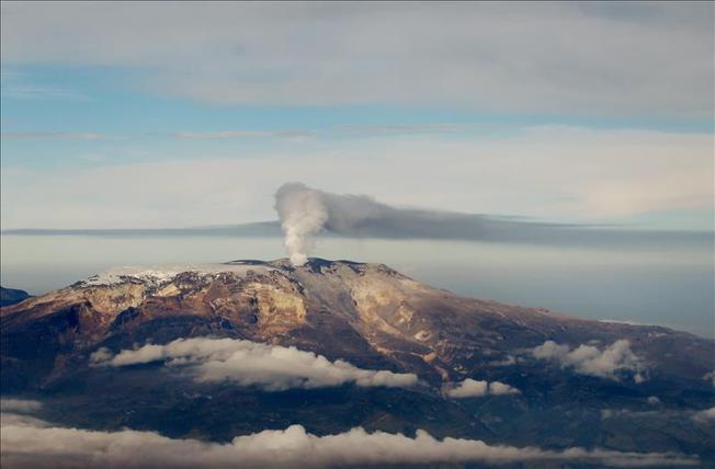
Finally, the new crater of the Southeast is active again at its eastern end, but with less intensity than other craters. In fact, this crater produces only weak strombolian explosions interspersed with long breaks of activity (figure 4).
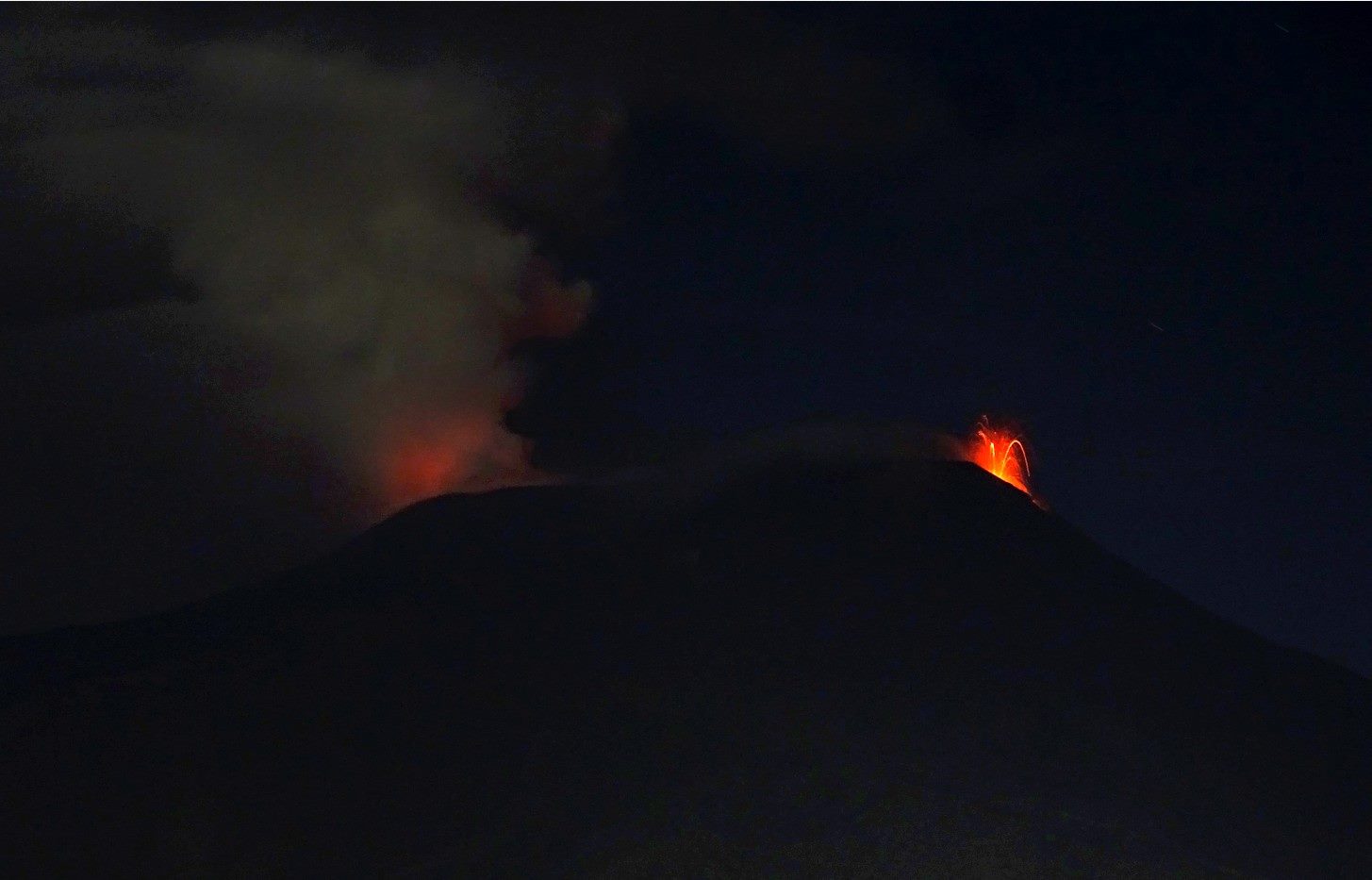
Figure 4 – View of the summit of the crater of Etna taken from the South-East on the evening of August 22, 2018. On the left, lightning produced by the Strombolian activity of the Bocca Nuova. On the right, a small Strombolian explosion at the new crater of the Southeast. Photo of Boris Behncke.
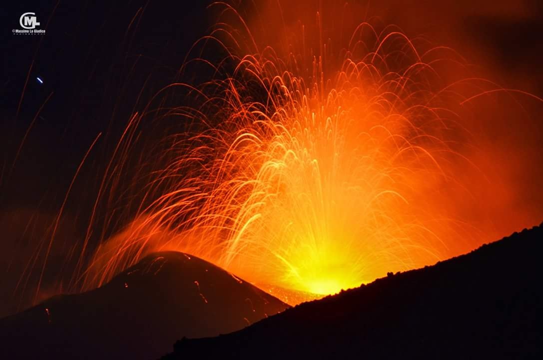
Note from the Cauldron: Last night, the activity has intensified. ( see the video) .
https://www.facebook.com/salvatore.l.giudice.77/videos/10212707956282432/
The release of the INGV is not yet published.
After a long break, Etna is erupting right now! There is currently low intensity activity from the NSEC « Bocca della Sella » (New Southeast Crater) and short lava flows along the southeast flank of the summit area. If you wish to watch it, the live broadcast is available on the link below.
http://www.skylinewebcams.com/…/catan…/vulcano-etna-sud.html
Enjoy the majesty of « Mamma » Etna.
If you want more details: www.ct.ingv.it (volcanic tremor, real-time seismic signals and thermal imaging cameras available)
Source : Marco Neri , Boris behncke . /https://ingvvulcani.wordpress.com/2018/08/23/aumenta-di-intensita-lattivita-eruttiva-sommitale-delletna/
Vidéo : S . Lo Giudice.
Photo et commentaire : Simone Aveni.
Colombia , Nevado del Ruiz :
Subject: Activity bulletin of the Nevado del Ruiz volcano.
The level of activity continues at the level: Yellow activity level or (III): changes in the behavior of volcanic activity.
With regard to monitoring the activity of the Nevado del Ruiz volcano, the COLOMBIAN GEOLOGICAL SERVICE informs that:
During the past week, the seismicity caused by the fracturing of the rocks that make up the volcano has resulted in an increase in the number of earthquakes and seismic energy released compared to the previous week. The earthquakes were mainly in the South-South-East, North-West, North-East of the volcano and in the Arenas Crater, at depths between 0.5 and 8.0 km. The maximum magnitude recorded during the week was 1.4 ML (local magnitude) for the earthquake that occurred on August 14 at 6:47 pm (local time), located 6.1 km northwest of the Arenas crater at a depth of 7.3 km.
The seismicity related to fluid dynamics inside the volcanic structure ducts showed a slight decrease in the number of earthquakes and released seismic energy compared to the previous week. This type of seismic activity was characterized by the occurrence of earthquakes of variable energy levels, long period (LP), very long period (VLP) and pulses of volcanic tremor. The earthquakes were located mainly in the Arenas crater. Some of these seismic signals were associated with low emissions of gas and ash into the atmosphere, as evidenced by the images captured by cameras in the volcano area and by the Los Nevados National Park (PNNN) staff. These ash emissions have been reported to civil aviation through VONA notifications (Aviation Volcano Observatory Notice).
Volcanic deformations measured from electronic inclinometers, Global Navigation Satellite System (GNSS) stations and radar images show until now a stability behavior without recording any important process of deformation of the volcanic structure.
The volcano continues to emit in the atmosphere of water vapor and gases, including sulfur dioxide (SO2) which is highlighted, as shown by the values obtained by the SCANDOAS stations installed in the volcano zone and satellite image analysis. In tracking information provided by NASA’s FIRMS portal, a low-energy thermal anomaly was recorded during this week.
The column of gas and steam reached a maximum height of 550 meters measured at the top of the volcano on August 14th. The direction of dispersal of the column was governed by the direction of the wind in the area which, during the week, prevailed to the northwest relative to the crater Arenas.
The Nevado del Ruiz volcano continues at the Yellow activity level.
Source : SGC
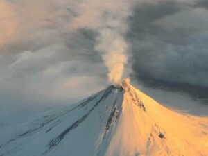
Fuego , Guatemala :
Type of activity: Vulcanian
Morphology: Composite Stratovolcano
Location: 14 ° 28’54˝ Latitude N, 90 ° 52’54˝Longitude W
Height: 3,763msnm.
Weather conditions: Clear
Wind: South at 6 km / h.
Precipitation: 0.0 mm.
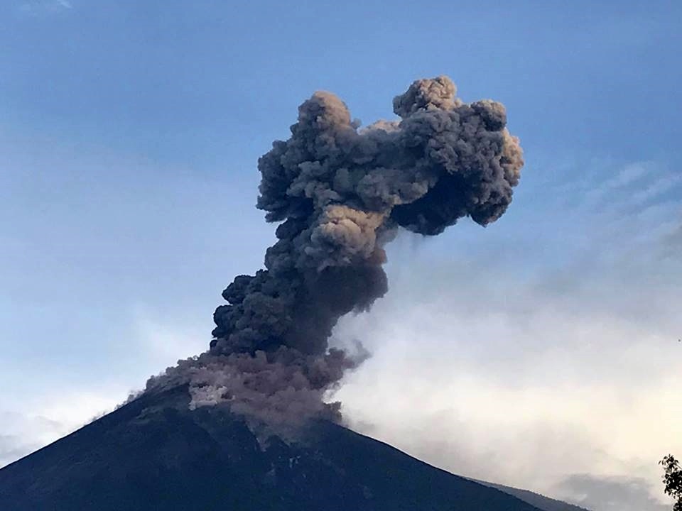
Activity:
As reported, the Fuego volcano has changed its eruptive pattern, it is observed with weak to moderate explosions, ejecting columns of gray ash at a height of 4300 to 4600 meters above sea level. (14107 – 15419 feet) moving west and north-west at a distance of 12 kilometers. Fallen ash particles are reported from Sangre de Cristo, Morelia, Santa Sofia and Panimache villages. Some avalanches of blocks roll along the flanks of the volcano. In the afternoon and evening, there is a chance of rain in the volcanic area, so lahars can be generated in the different ravines around the Fuego volcano, so take precautions.
Source : Insivumeh
Photo : Kevin Godbee
Indonesia , Anak Krakatau :
Information on the eruption of G. Anak Krakatau
August 23, 2018
An eruption of Mount Anak Krakatau, Lampung occurred on August 23, 2018 at 18:07 WIB with a height of the ash column observed at ± 700 m above the summit (± 1,005 m above sea level).
The column of ash observed is black with a thick intensity inclined to the northeast. This eruption is recorded on a seismogram with a maximum amplitude of 27 mm and a duration of ± 31 seconds.
There was a roaring noise and there was a vibration with a low intensity at the PGA position
Currently, G. Anak Krakatau is at Level II (WASPADA)
Recommendation: People / tourists are not allowed to approach the crater within 2 km of the crater.

VOLCANO OBSERVATORY NOTICE FOR AVIATION – VONA.
Issued: August 23 , 2018.
Volcano: Anak Krakatau (262000)
Current Aviation Colour Code: ORANGE
Previous Aviation Colour Code: orange
Source: Anak Krakatau Volcano Observatory
Notice Number: 2018KRA33
Volcano Location: S 06 deg 06 min 07 sec E 105 deg 25 min 23 sec
Area: Lampung, Indonesia
Summit Elevation: 976 FT (305 M)
Volcanic Activity Summary:
Eruption with ash clouds at 11:07 UTC (18:07 local time). The eruption lasted for 31 seconds. Eruption and ash emission is continuing.
Volcanic Cloud Height:
Best estimate of ash-cloud top is around 3216 FT (1005 M) above sea level, may be higher than what can be observed clearly. Source of height data: ground observer.
Other Volcanic Cloud Information:
Ash-cloud moving to northeast.
Remarks:
Eruption recorded on seismogram with maximum amplitude 27 mm and maximum duration 31 second.
Source : Agence géologique, PVMBG , Magma Indonésie.
Photo : Oystein Lund Andersen.