May 13 , 2018.
Pu’u ‘Ō’ō / Kilauea , Hawai :
Update on the East Rift Zone eruption for Saturday, May 12 at 6 am
This is a civil defense message for Saturday, May 12, 2018 at 06:00.
The Hawaiian Volcano observatory reports that volcanic activity in the lower East Rift zone of Kīlauea Volcano continues. None of the 15 vents have produced lava since Thursday. Continuous earthquakes, soil deformation, and sulfur dioxide emissions mean that other lava flows are possible.
The HVO declares that an explosive eruption of the Halema’uma’u crater is possible. This could generate ash plumes that could affect a 12-mile zone of the summit crater.
Due to volcanic activity, the following elements are emitted:
Residents of Lower Puna between Kapoho and Kalapana are advised to be on alert for possible gas emissions and volcanic eruptions. There may be little or no notice to evacuate, so take the time to prepare.
If you evacuate voluntarily, the Pahoa Community Center and the Kea’au Community Center are open. Food will be provided and the refuges accept pets.
Under the emergency provisions, any looting or vandalism in an emergency situation is considered a crime.
Saturday, May 12, 2018, 9:10 AM HST (Saturday, May 12, 2018, 19:10 UTC)
Summary:
LOWER EAST RIFT ZONE
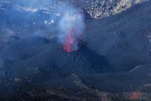
Minor spattering activity has been reported from a new fissure (16) that has opened about 0645 this morning about 1 mile northeast of fissure 15 at the northeast end of the existing vent system. No significant lava flow from this new fissure has been reported or observed at this time, but conditions could change quickly. Elevated earthquake activity and ground deformation continue and additional outbreaks in the area remain likely.
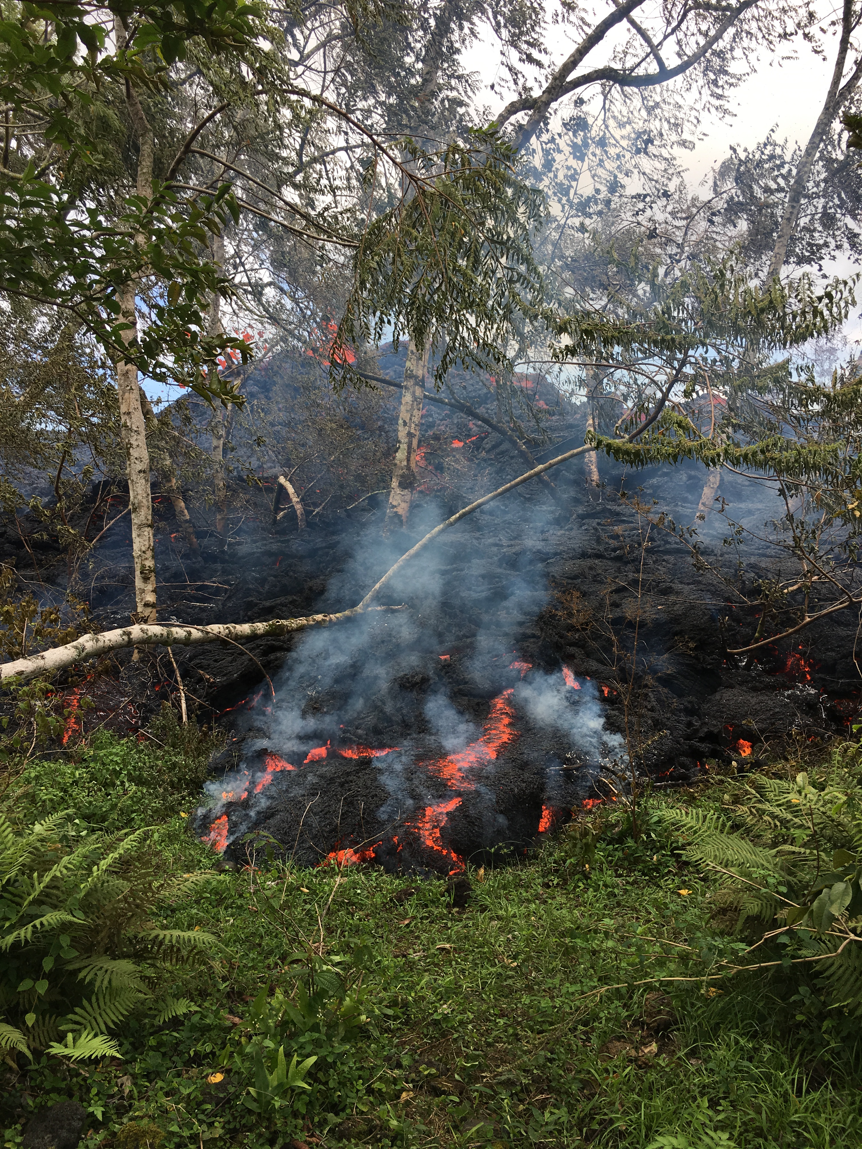
At 12:57 p.m. HST, lava was slowly advancing from fissure 16.
KILAUEA SUMMIT
Deflationary tilt at the summit of the volcano continues and seismicity remains elevated. This morning, a steady, vigorous plume of steam and variable amounts of ash is rising from the Overlook vent. Occasional rockfalls into the deep vent will produce intermittent pulses of slightly more vigorous ash emissions. Depending on wind conditions, dustings of ash may occur in the Kilauea summit area and downwind. More energetic ash emissions are possible if explosive activity commences.
This morning’s trade winds are carrying the plume and ash to the southwest of the Kilauea summit. Trade wind conditions are expected to continue according to current forecasts.
USGS/HVO continues to monitor the situation at the summit and the lower East Rift Zone 24/7 in coordination with Hawaii County Civil Defense and other authorities. Field crews are onsite in the Leilani Estates area this morning examining the fissure vents and searching for any signs of new or resumed activity.
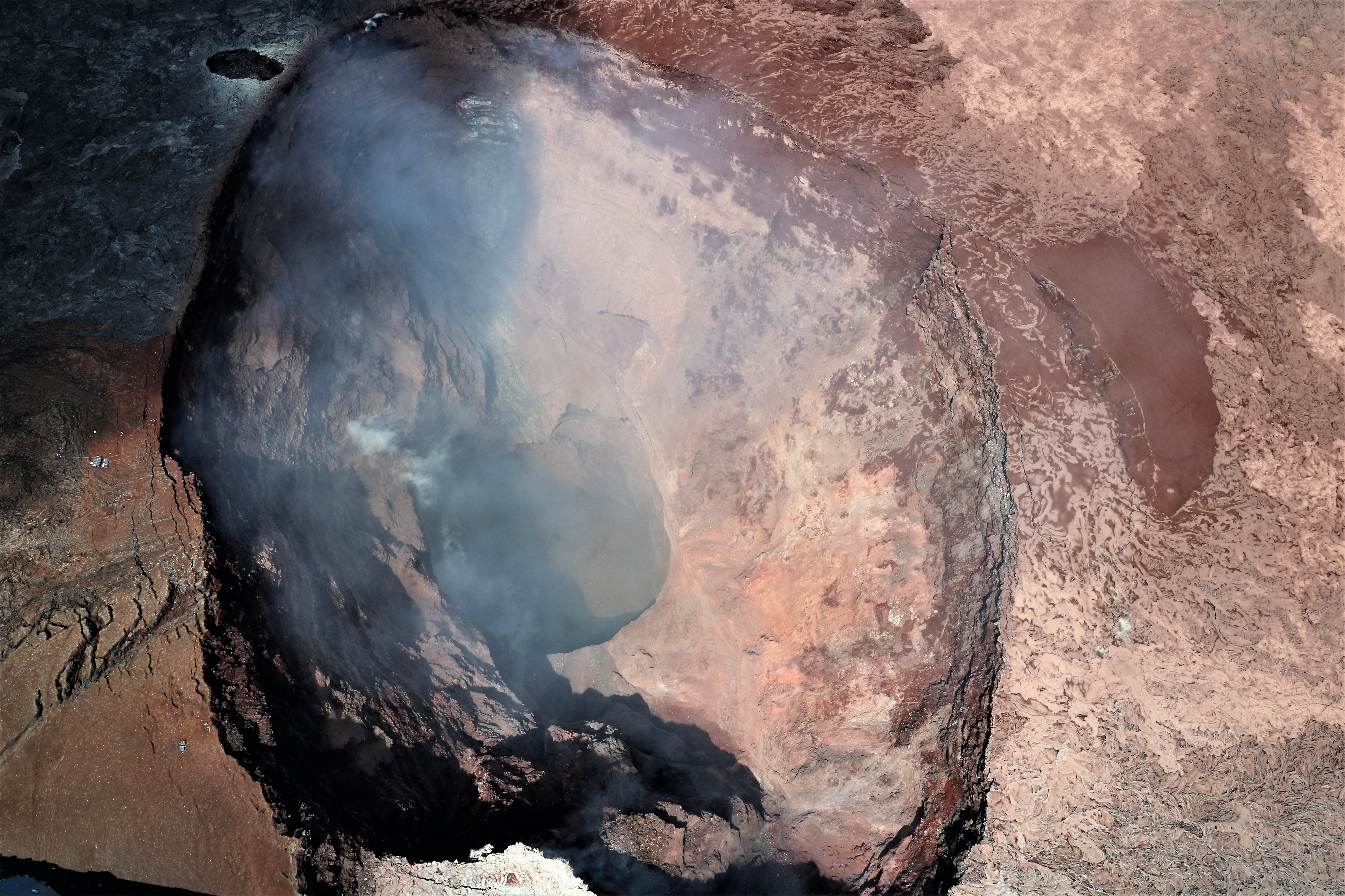
A clear view into Pu‘u ‘Ō‘ō crater. The upper part of the crater has a flared geometry, which narrows to a deep circular shaft. The deepest part of the crater is about 350 m (1150 ft) below the crater rim.
051218 10:00am County of Hawaii Civil Defense message about eruptive fissure 16.
This is a Civil Defense Message for Saturday, May 12, 2018 at 10 AM.
Hawaiian Volcano Observatory reports a new fissure in the lower East Rift Zone. Lava spatter was reported east of the geothermal plant property and northeast of Lanipuna Subdivision. Highway 132, also known as Pahoa-Kapoho Road is open.
Continuing earthquakes, ground deformation, and sulphur dioxide emissions mean additional outbreaks of lava are possible.
HVO states that an explosive eruption at Halema’uma’u Crater is possible. This could generate ash plumes and dangerous debris that may affect an area as far as 12 miles from the summit crater.
Source : HVO
Photos et video : USGS / HVO.
Reventador , Ecuador:
The Geophysical Institute of the National Polytechnic School (IGEPN) carried out several monitoring tasks on the El Reventador volcano during the month of April. Here are the air missions performed:
1.- Overview of April 12, 2018.
With the help of a CESSNA 206 type aircraft under the command of Cape. Richard Morales of the company Alas de Socorro of Ecuador, it was possible to make an overflight of the volcano on April 12, 2018.
The changes observed in the crater morphology of the volcano are mainly due to the explosive eruptive activity that it has maintained continuously since its last eruption in June 2017 and correspond mainly to the high rate of accumulation of material at the top of the volcano. result in an increase in its height and the generation of small pyroclastic density currents (eg, pyroclastic flows and secondary collapses of accumulated volcanic material at the top (Figure 1).
The deposits located on the flanks of the volcano correspond to the descent of pyroclastic materials: currents of pyroclastic density and ballistic projectiles. In both cases the litters are quite large, with up to 800 meters in a straight line from the crater; mainly on the north-east and south flanks.
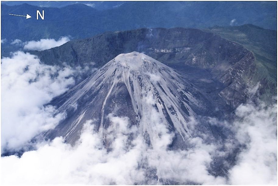
Figure 1. Photograph of the El Reventador volcano, pyroclastic flows are observed on almost all sides of the volcano (Photo: F Naranjo – IGEPN, 04-12-2018).
The activity observed during the flight was very rare, in 20 minutes of permanence around the volcano we could observe an explosion, which significantly reduces the number of events reported in previous reports, however, the volcano maintains a Vulcanian-type activity, that is to say, strong explosions accompanied by « cannon shots » with emission columns more than 1.5 km high, with moderate to high ash loads (Figure 2 ).
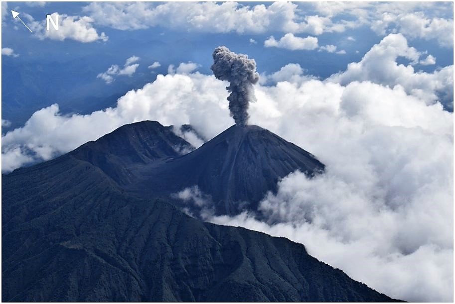
Figure 2. Photograph of the El Reventador volcano, there is a small explosion with a moderate ash load (Photo: F Naranjo – IGEPN, 04-12-2018).
The capture conditions of images and thermal sequences were optimal, without the influence of solar radiation. It was possible to distinguish some deposits of pyroclastic flows that had descended the previous days. No new lava flows were observed. The highest apparent temperatures (TMA) are associated with the two vents: North vent (NV) with a TMA of 355 ° C, South vent (SV) with a TMA of 254 ° C. In particular, a fumarole field is observed , aligned, between the possible contact of the recent pyroclastic material and past lava flows, possibly those released in August 2017 (Figure 3).
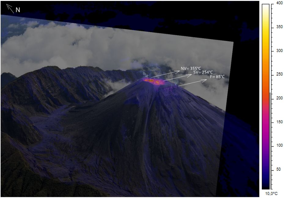
Figure 3. Overlay of photographs + thermal image of the El Reventador volcano, the two vents and the aligned fumarolic field are observed (Photo: F Naranjo – IGEPN, IR Image: M Almeida – IGEPN, 04-12-2018).
… / …
Follow-up overview of April 26, 2018:
In principle, photographs and thermal images of the lava flow of June 2017 are taken, with the aim of subsequently reconstructing a digital elevation model and thus better to estimate the flow distribution and its volume. Then, a visual / thermal monitoring is carried out and the appearance of a new lava flow towards the N of the volcano is observed. The thermal image analysis indicates a maximum apparent temperature (TMA) of 487 ° C at the edge of the flow (Figure 6).
On the basis of the analysis of the photographic equipment and thermal imaging (IR) obtained during flights of 12 and 26 April and next to the location of the thermal alert identified by the MODIS satellite, it was confirmed a new lava flow (Figures 6 and 8). It is estimated that this lava flow would have descended to the west – northwest flanks of the volcano and would have been distributed to the west (Figure 6) and to the northwest by the base of the caldera. Later on May 5, 2018, with a visible camera and a long exposure of one of the points of view of the hostel El Reventador it was possible to observe an intense luminosity in the Northeast and towards the North-West, which suggests that the flow remains active in the movement, but these flows are usually limited to the highlands of the volcano without posing a risk to the surrounding communities. The shooting date would be approximately 1 km in length when reaching the northern limit of the caldera.
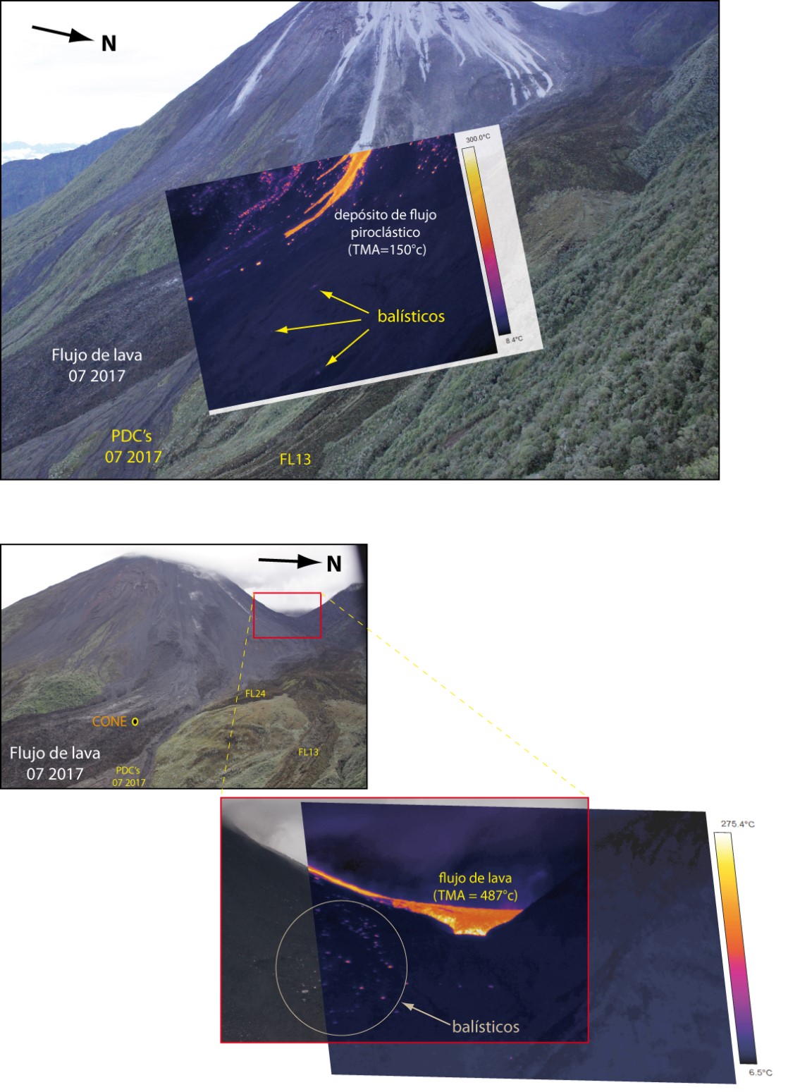
Figure 6. Top, photo taken NE of the volcano. The June 2017 lava flow and pyroclastic deposits are observed. The red frame shows the enlarged photo of the new lava flow. Lower, superposition of the thermal image on the photo of the lava flow. The anomalies identified also correspond to the presence of rolled and ballistic blocks (Photo: S Vallejo, P Ramón, IR image: M Almeida, IG-EPN).
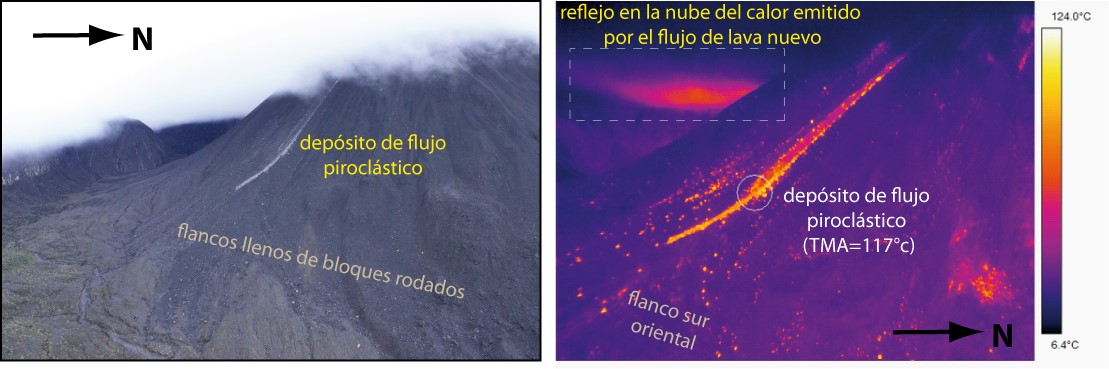
Figure 7. Left, photo of the southeast flank of the volcano with a pyroclastic flow deposit. On the right, the corresponding thermal image, light cloud volcano west seen suggesting the presence of lava flows in this part of the volcano (Photo: S Vallejo, IR image: M Almeida, IG-EPN).
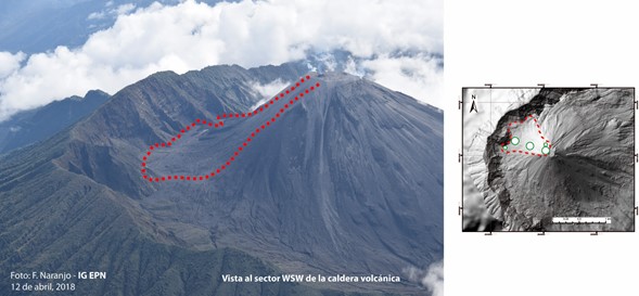
Figure 8. Photograph of the western flank of the El Reventador volcano, indicated in red dotted line, is the estimated distribution of the new lava flow generated in April 2018 (Photo: F Naranjo, IG-EPN 04 / 12/2017).
… / …
CONCLUSIONS:
It has been noted that the activity of the volcano remains at a level considered high.
Constant explosions give rise to the generation of pyroclastic flows of different ranges (max dist = 1.6 km), in addition to the ejection of ballistic blocks that can reach different distances from the crater (dist max = 1.8 km).
The continuous emission of gas and ash with preferential direction to the west was observed when the volcano was clear.
Due to the presence of the material generated after the eruptive activity of 2017 and the present, in April 2018, in addition to the combination of heavy rains in the upper part of the volcano, it is considered likely the appearance of lahars and the flow of muddy water in the main drainages of the volcano (Ríos Marker, Río Reventador and Río Azuela); which could cause disruption and interruption of the road in these sections.
There are areas of the volcano that could cause accidents or small avalanches due to the influence of eruptive force in the volcano and its scope may be variable. It is important to consider this aspect in the evaluation of the volcanic threat.
Source : IGEPN
Piton de la Fournaise , La Réunion :
Activity Bulletin from Saturday, May 12, 2018 at 3:30 pm (local time):
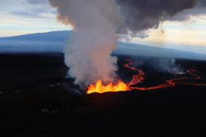
The eruption started on April 27, 2018 at 23:50 local time continues. After a very slight drop in intensity at the end of the day yesterday, the volcanic tremor (indicator of the eruptive intensity at the surface) is again relatively stable .
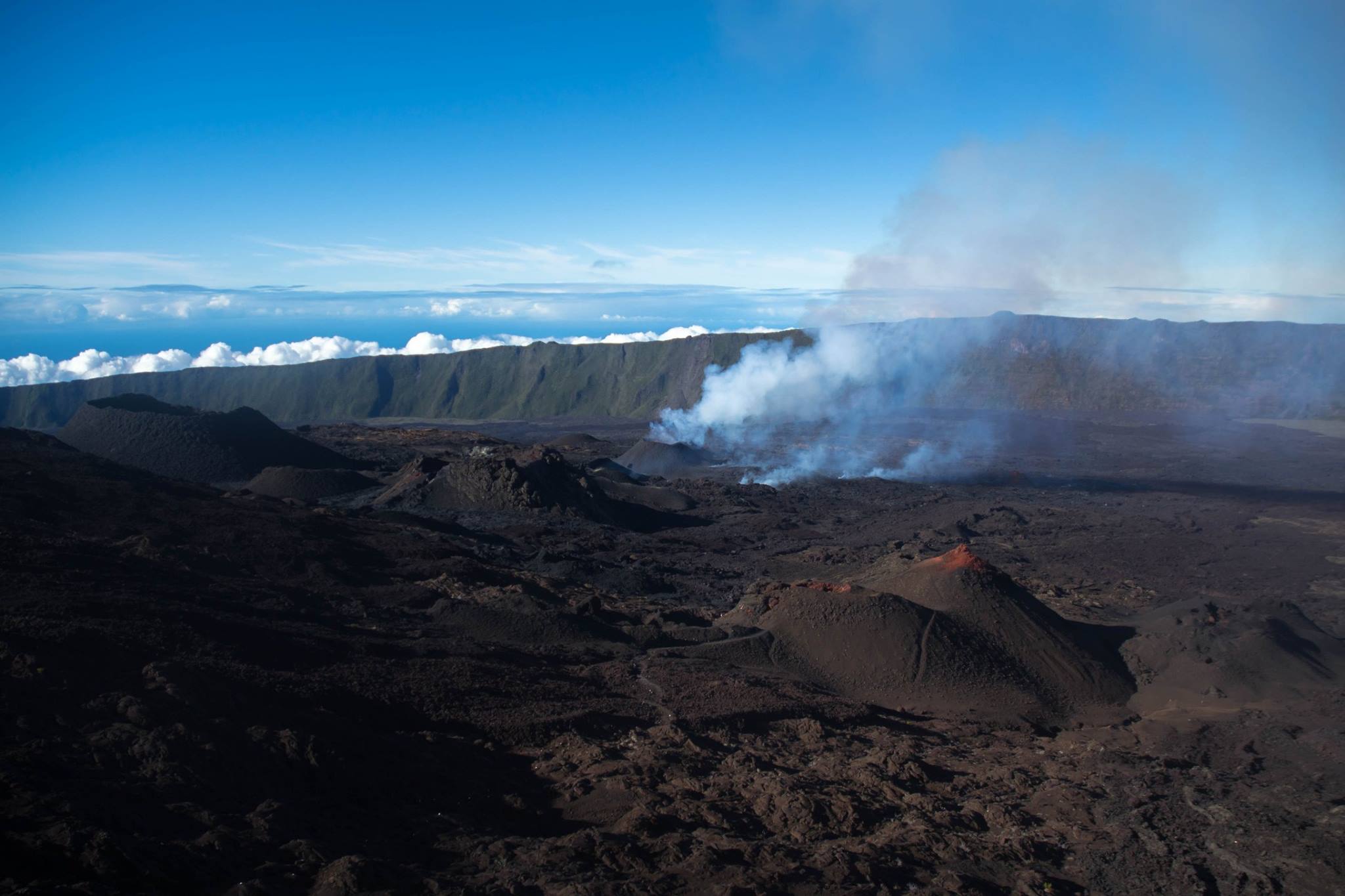
– The activity now taking place mainly in lava tunnels, the surface flows could not be estimated today from the satellite data.
– No significant deformation has been recorded since.
– No volcano-tectonic earthquake has been recorded in the last 24 hours under the Piton de la Fournaise building.
Alert level: Alert 2-2 – Eruption in the Enclos .
Source : OVPF
Photo : Fournaise Infos
Ebeko , Kamchatka :
VOLCANO OBSERVATORY NOTICE FOR AVIATION (VONA).
Issued: May 13 , 2018.
Volcano:Ebeko (CAVW #290380)
Current aviation colour code:ORANGE
Previous aviation colour code:orange
Source:KVERT
Notice Number:2018-45
Volcano Location:N 50 deg 41 min E 156 deg 0 min
Area:Northern Kuriles, Russia
Summit Elevation:
3791.68 ft (1156 m)
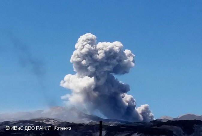
Ash burst from Active crater of Ebeko volcano on 06 June, 2017.
Volcanic Activity Summary:
Ash plume extended for about 20 km to the south-west from the volcano.
A moderate gas-steam with some amount of ash activity of the volcano continues. Ash explosions up to 16,400 ft (5 km) a.s.l. could occur at any time. Ongoing activity could affect low-flying aircraft and airport of Severo-Kurilsk.
Volcanic cloud height:
6560-8200 ft (2000-2500 m) AMSL Time and method of ash plume/cloud height determination: 20180513/0140Z – Himawari-8
Other volcanic cloud information:
Distance of ash plume/cloud of the volcano: 12 mi (20 km)
Direction of drift of ash plume/cloud of the volcano: SW / azimuth 221 deg
Time and method of ash plume/cloud determination: 20180513/0140Z – Himawari-8
Source : Kvert
Photo : L. Kotenko, IVS FEB RAS , 6/6/2017
Popocatépetl , Mexico :
May 12, 11:00 am (May 12, 4:00 pm GMT)
In the last 24 hours, according to the surveillance systems of the Popocatepetl volcano, 51 low intensity exhalations accompanied by water vapor and gas have been identified.
For most of the night, there was a glow on the crater.
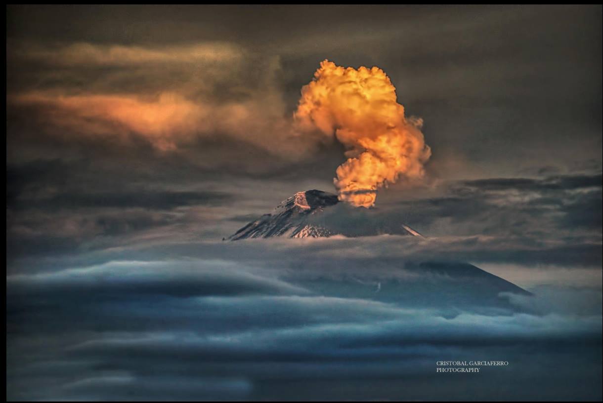
During the morning, the crater of the volcano was observed with a continuous emission of water vapor and gas, with 600 m height in the north-east direction.
CENAPRED urges not to approach the volcano and especially the crater, because of the risk of falling ballistic fragments and in case of heavy rains to move away from the bottom of the ravines because of the risk of landslides and floods. mud.
The volcanic warning light of the Popocatepetl volcano is located at Amarillo Phase 2.
Source : Cenapred.
Photo : Cristobal Garciaferro