December 01 , 2022.
Hawaii , Mauna Loa :
Lava flows on the northeast flank of Mauna Loa in Hawaii submerged and destroyed the access road leading to the famous Mauna Loa Observatory, one of the most important atmospheric observatories in the world.
The lava that engulfed the only driveable access road to the observatory also destroyed the power lines that supplied power to the structure, so all instruments are now completely out of service as of late Monday afternoon. . American researchers are evaluating in these hours to transfer the most important instruments elsewhere through the use of a helicopter while waiting for the end of the eruption.

HAWAIIAN VOLCANO OBSERVATORY DAILY UPDATE
U.S. Geological Survey
Wednesday, November 30, 2022, 9:08 AM HST (Wednesday, November 30, 2022, 19:08 UTC)
19°28’30 » N 155°36’29 » W,
Summit Elevation 13681 ft (4170 m)
Current Volcano Alert Level: WARNING
Current Aviation Color Code: RED
Activity Summary:
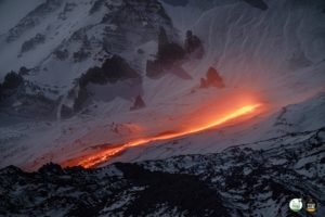
The Northeast Rift Zone eruption of Mauna Loa continues, with two active fissures feeding lava flows downslope. The fissure 3 lava flows are travelling to the northeast, though the direction shifted slightly westward overnight, still moving toward Saddle Road. Fissure 3 is the dominant source of the largest lava flow, and the flow front is about 3.6 miles (5.8 km) from Saddle Road as of 7 a.m. HST this morning. The flows have been advancing at a rate of 0.08 miles per hour (130 meters per hour) over the last day, but they are approaching a relatively flat area and will begin to slow down, spread out, and inflate. Forecasts indicate it may take two days for lava flows to reach Saddle Road.
Aerial image of fissure 3 on Mauna Loa’s Northeast Rift Zone erupting the morning of November 30, 2022. Fissure 3 remains the dominant source of the largest lava flow being generated during the eruption.
Fissure 4 is still active with lava flows moving toward the northeast at 0.03 miles per hour (50 meters per hour). A small lobe is moving to the east from fissure 4 at a slower rate than the main lobe. Volcanic gas plumes are lofting high and vertically into the atmosphere. Pele’s hair (strands of volcanic glass) is falling in the Saddle Road area.
Our seismic monitoring detects tremor (high rates of earthquakes) in the location of the currently active fissures. This indicates that magma is still being supplied, and activity is likely to continue as long as we see this signal.
There is no active lava within Moku’āweoweo caldera, and the Southwest Rift Zone is not erupting. We do not expect any eruptive activity outside the Northeast Rift Zone. No property is at risk currently.
HAWAIIAN VOLCANO OBSERVATORY STATUS REPORT
U.S. Geological Survey
Wednesday, November 30, 2022, 4:10 PM HST (Thursday, December 1, 2022, 02:10 UTC)
19°28’30 » N 155°36’29 » W,
Summit Elevation 13681 ft (4170 m)
Current Volcano Alert Level: WARNING
Current Aviation Color Code: RED
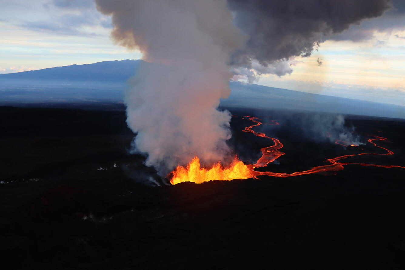
The Northeast Rift Zone eruption of Mauna Loa continues, with two active fissures feeding lava flows downslope. The fissure 3 lava flows are travelling to the north, still moving toward the Daniel K. Inouye Highway (Saddle Road). Fissure 3 remains the dominant source of the largest lava flow. Advance of the largest flow slowed between 7 a.m. and 12:30 p.m. HST today to a rate of 0.02 miles per hour (24 meters per hour). As of 12:30 HST p.m. today, the flow front remained about 3.6 miles (5.8 km) from the Daniel K. Inouye Highway (Saddle Road). The flows are reaching a relatively flat area and are beginning to slow down; as this happens, the lava flow will spread out and inflate. Forecasts indicate it may take two days for lava flows to reach the Daniel K. Inouye Highway (Saddle Road).
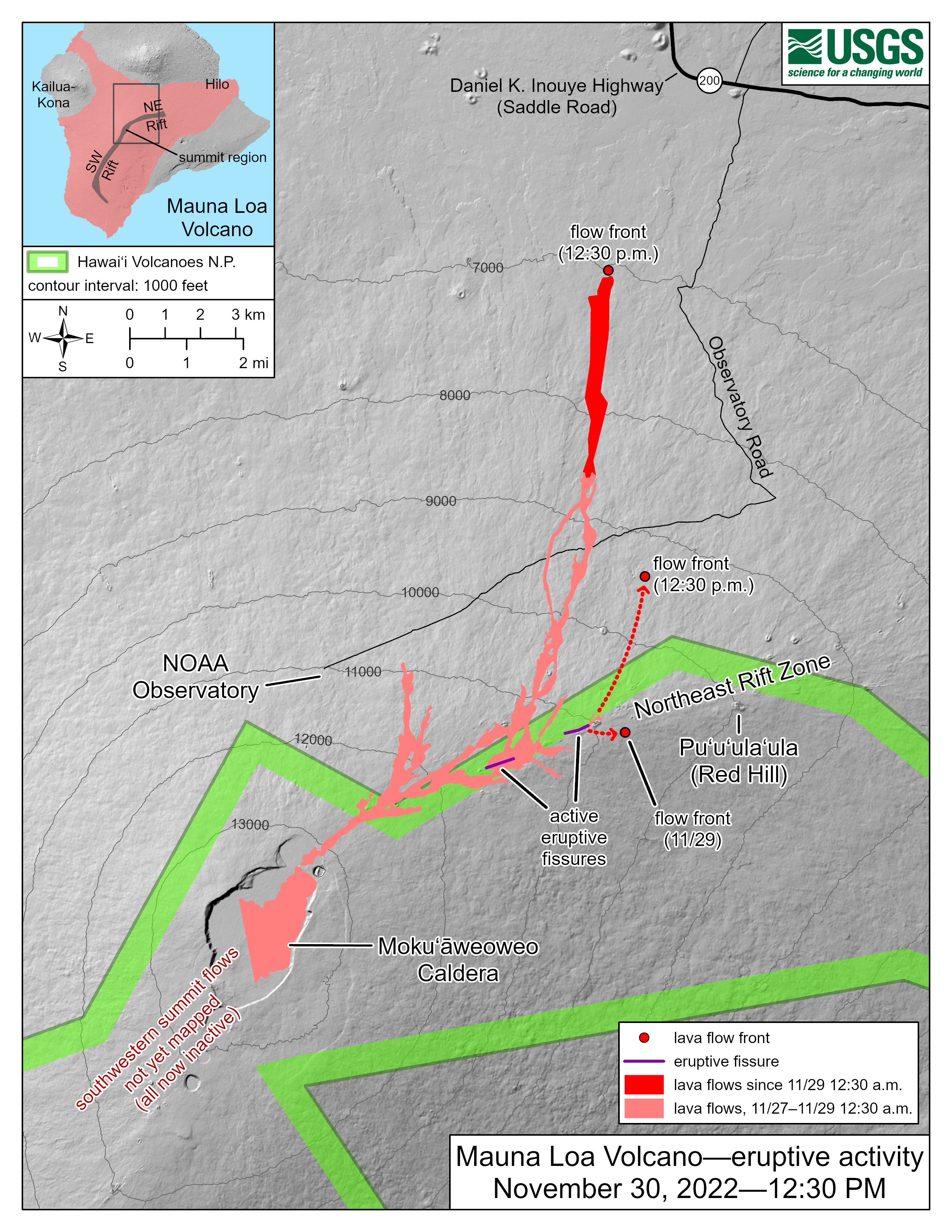
The Northeast Rift Zone eruption of Mauna Loa has continued into its third full day. At this time two fissures are active, sending lava flows primarily to the north-northeast. Webcam and satellite views overnight allowed USGS analysts to accurately map some of the most active flows, displayed in red here, along with older flows further uprift and in part of Mokuʻāweoweo Caldera. Elsewhere the progression of the flows is marked by dashed lines and points for the flow fronts, mapped by HVO field crews. As of 12:30 p.m. today, the most downslope flow is within 4 miles (6 kilometers) of the Daniel K. Inouye Highway (Saddle Road).
Fissure 4 is still active with lava flows moving toward the northeast. A small lobe is moving to the east from fissure 4 at a slower rate than the main lobe. Volcanic gas plumes are lofting high and vertically into the atmosphere. Pele’s hair (strands of volcanic glass) is falling in the Humu‘ula Saddle area.
Our seismic monitoring detects tremor (high rates of earthquakes) in the location of the currently active fissures. This indicates that magma is still being supplied, and activity is likely to continue as long as we see this signal.
There is no active lava within Moku’āweoweo caldera, and the Southwest Rift Zone is not erupting. We do not expect any eruptive activity outside the Northeast Rift Zone. No property is at risk currently.
Source : Il Mondo dei Terremoti , HVO
Photos : Andrew Richard Hara / Paradise Helicopters. USGS/ K. Mulliken.
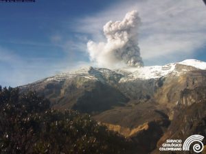
Italy / Sicily , Etna :
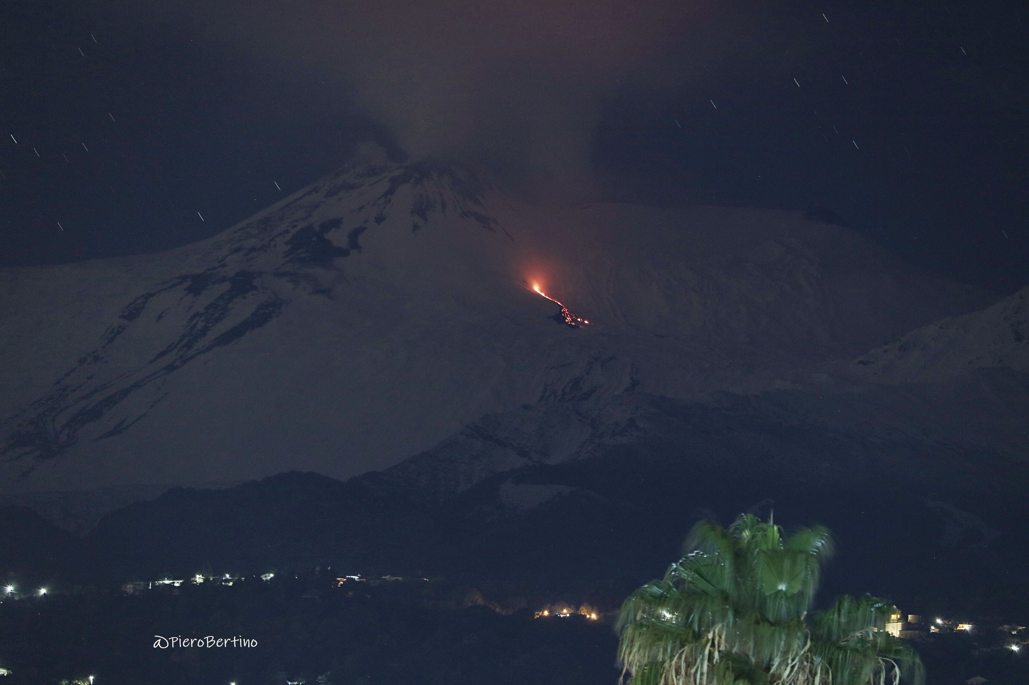
Press release on ETNA activity, November 30, 2022, 12:56 (11:56 UTC)
The National Institute of Geophysics and Volcanology, Osservatorio Etneo, announces that the effusive activity reported in the press release of 27/11/2022 (17:52 UTC) continues. In particular, the front of the flow fed by the vent located at an altitude of approximately 2800 m advanced only a few hundred meters into the Valle del Leone; in recent days, the eruptive vent has also fed other small flows that partially overlapped the flow described in the first release.
From a seismic point of view, from about 16 UTC yesterday, the average amplitude of the volcanic tremor showed a gradual increase and reached, after about an hour, the level of high values. In the following hours and up to the current state, the amplitude of the tremor fluctuated and shows various fluctuations between medium to high values. The center of gravity of the sources of volcanic tremors is located in the area between the Southeast Crater and the Bocca Nuova Crater, in a depth range between 2000 and 2600 m above sea level.
At present, infrasound activity remains at low levels and is primarily attributable to activity from the Bocca Nuova crater.
Signals currently available from ground deformation monitoring networks have shown no significant changes over the past few hours.
Further updates will be communicated soon
Source : INGV.
Photo : Piero Bertino .
Chile , Hudson :
Special Report on Volcanic Activity (REAV), Aysen Del General Carlos Ibanez Del Campo Area, Hudson Volcano, November 30, 2022, 8:30 a.m. local time (mainland Chile).
The National Service of Geology and Mines of Chile (Sernageomin) publishes the following PRELIMINARY information, obtained through the monitoring equipment of the National Volcanic Monitoring Network (RNVV), processed and analyzed at the Volcanological Observatory of the Southern Andes ( Ovdas):
On Wednesday November 3, 2022, at 07:57 local time (10:57 UTC), the monitoring stations installed near the Hudson volcano recorded an earthquake associated with both rock fracturing (volcano-tectonic type) and fluid dynamics in the volcanic system (hybrid type).
The characteristics of earthquakes after their analysis are as follows:
ORIGINAL TIME: 07:57 local time (10:57 UTC)
LATITUDE: 45.905°S
LONGITUDE: 72.947°E
DEPTH: 4.5 km
REDUCED DISPLACEMENT: 502.1 (cm*cm)
LOCAL MAGNITUDE: 2.0 (ML)
The characteristics of the associated surface activity are as follows:
COMMENTS:
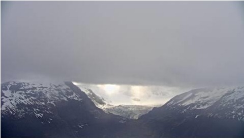
The images obtained from the Huemiles IP camera do not record any superficial activity due to the unfavorable weather conditions in the area. Following the event, the seismicity recorded corresponds mainly to low-energy volcano-tectonic earthquakes.
The volcanic technical alert remains at the Green level.
Source et photo : Sernageomin.
New Zealand , Lake Taupo :
On Wednesday 30 November at 11:47PM a M5.6 earthquake occurred under Lake Taupō and was felt throughout the Waikato and the central North Island.
The M5.6 mainshock was 9km deep, and has been followed by over 180 aftershocks, the largest being a M4.5. Around 30 of the aftershocks have been reported felt.
We have had received a range of reports of damage from items falling off shelves to roof damage at a business in Taupō.
This is the largest earthquake in the Lake Taupō region since a M5.0 earthquake in 2019 and follows an increase of earthquakes in the region since May 2022, when the current period of unrest at Taupō volcano began.
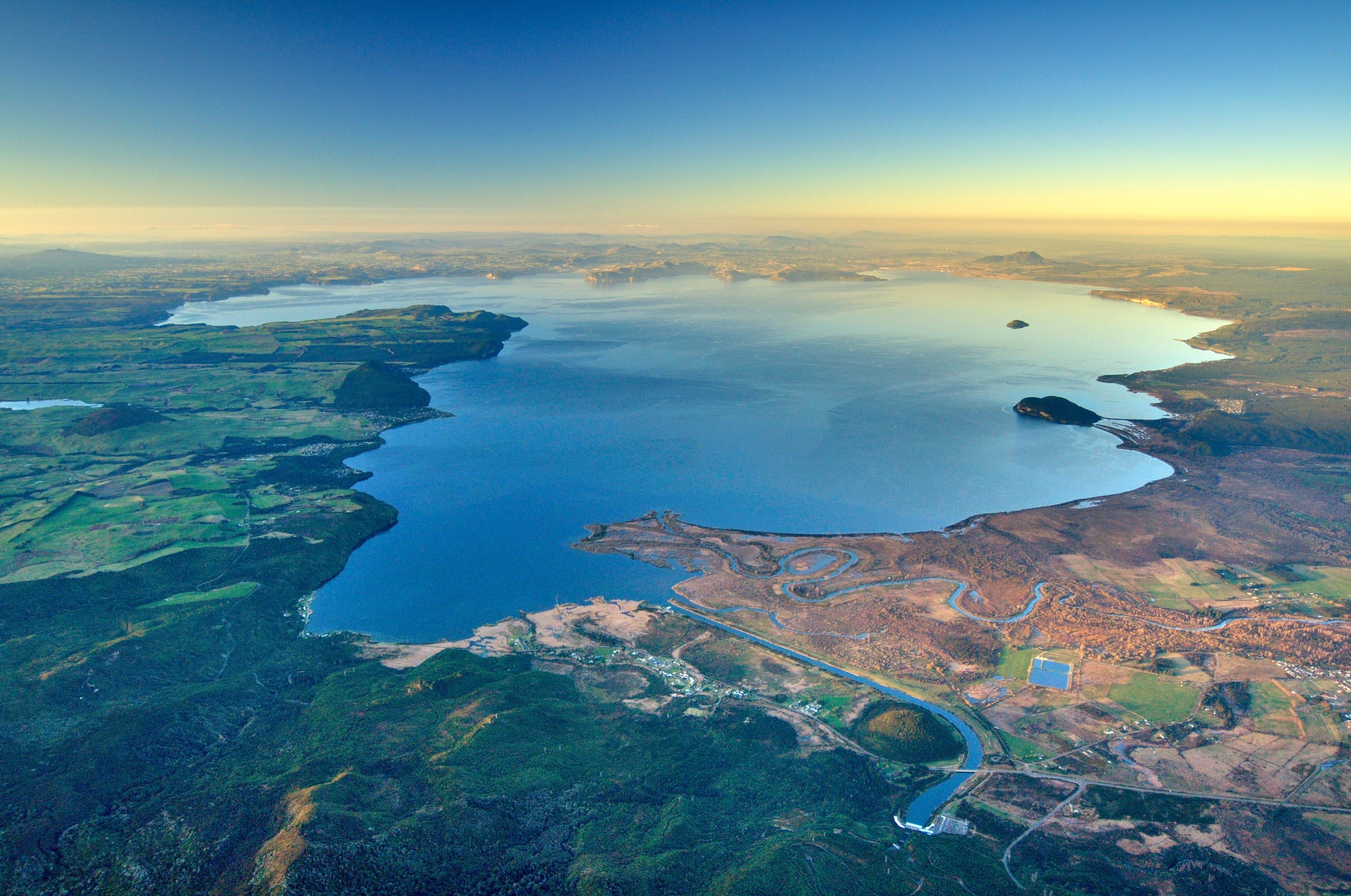
We believe the earthquake sequence to be caused by activity associated with magma and hydrothermal fluids inside the volcano. This activity could continue for the coming weeks or months, at varying rates or intensities.
In response to this increase in volcanic unrest at Taupō volcano, shown by continued small earthquakes and ground deformation, we raised the Volcanic alert Level from 0 to 1.
Caldera volcanoes such as Taupō often undergo unrest that lasts from months to years, without leading to eruption. Taupō has had 17 episodes of unrest in the past 150 years, and none of them led to an eruption.
Source et photo : Geonet.
Japon , Suwanosejima :
JMA reported that the eruption at Suwanosejima’s Ontake Crater continued during 21-28 November and crater incandescence was visible nightly. Eruption plumes rose as high as 1.3 km above the crater rim and blocks were ejected as far as 300 m from the vent. Ashfall was occasionally reported in Toshima village (3.5 km SSW). The Alert Level remained at 3 (on a 5-level scale), and residents were warned to stay 2 km away from the crater.
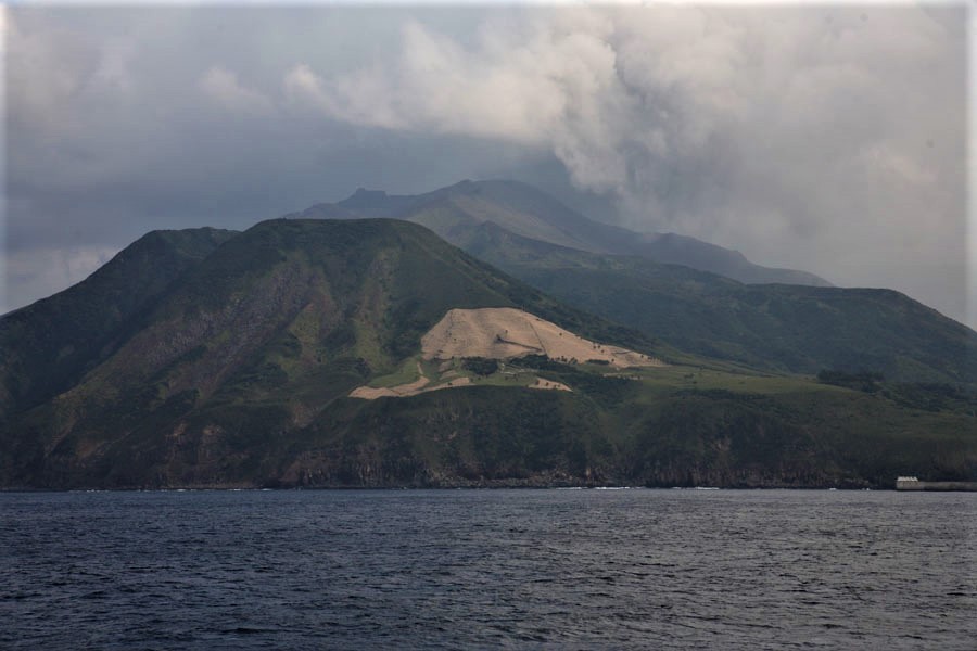
The 8-km-long island of Suwanosejima in the northern Ryukyu Islands consists of an andesitic stratovolcano with two historically active summit craters. The summit is truncated by a large breached crater extending to the sea on the east flank that was formed by edifice collapse. One of Japan’s most frequently active volcanoes, it was in a state of intermittent Strombolian activity from Otake, the NE summit crater, between 1949 and 1996, after which periods of inactivity lengthened. The largest recorded eruption took place in 1813-14, when thick scoria deposits blanketed residential areas, and the SW crater produced two lava flows that reached the western coast. At the end of the eruption the summit of Otake collapsed, forming a large debris avalanche and creating the open Sakuchi caldera, which extends to the eastern coast. The island remained uninhabited for about 70 years after the 1813-1814 eruption. Lava flows reached the eastern coast of the island in 1884. Only about 50 people live on the island.
Source : Japan Meteorological Agency (JMA), GVP.
Photo : Photovolcanica