December 14 , 2021.
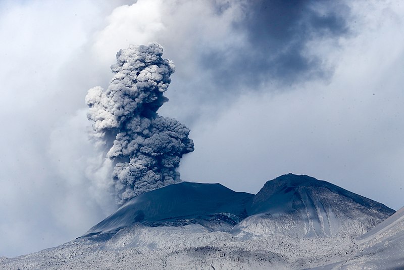
Italy / Sicily , Etna :
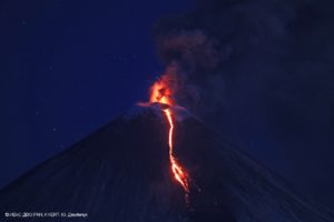
12 December 2021, 18:58 (17:58 UTC), Communication on the activity of ETNA.
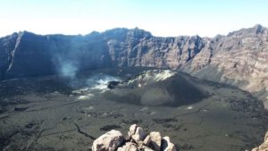
The National Institute of Geophysics and Volcanology, Osservatorio Etneo, reports that from around 4.30 p.m. UTC, weak intracrater Strombolian activity is observed from the Southeast crater. From 17:05 UTC the analysis of the images of the CCTV cameras shows the opening of an effusive vent at the base of the western wall of the Valle del Bove at an altitude estimated between 2200 and 2100 m above sea level, from where a small lava flow is emitted. Further updates will follow.

12 December 2021, 19:20 (18:20 UTC), Communication on the activity of ETNA.
The National Institute of Geophysics and Volcanology, Osservatorio Etneo reports that from a seismic point of view, the average amplitude of the volcanic tremor shows a modest increasing trend, remaining in the range of medium-high values. The rate of occurrence of infrasonic events is low.
Soil deformation monitoring networks do not record significant changes during the day today.
An inspection by INGV staff is in progress.
12 December 2021, 19:20 (18:20 UTC), Communication on the activity of ETNA.
The National Institute of Geophysics and Volcanology, Osservatorio Etneo announces that during the inspection carried out by the staff of INGV and from the images of the CCTV system, it was observed that the effusive vent reported in press release no. ° 524 produces a flow a few hundred meters long. The front of the flow forms small ramifications that reached the area of Mount Centenari, settling at an altitude estimated between 1700-1800 m above sea level. In correspondence of the effusive mouth, no explosive activity visible from a distance is observed.
From a seismic point of view, the gradual increase in the mean amplitude of the volcanic tremor continued. It has now reached the high value range. The infrasound activity, on the other hand, does not show significant variations.
Soil deformation monitoring networks did not record any significant changes.
Further updates will be communicated shortly.
Source : INGV.
Photos : Etna Walk / Giuseppe Distefano / Marco Restivo
Vanuatu Archipelago , Ambae / Yasur :
AMBAE VOLCANO ALERT BULLETIN , issued by the Vanuatu Meteorology and Geohazards Department on 07th December 2021 at 06:21 pm:
Volcanic activity at Ambae has slightly increased in the level of minor unrest. The Volcanic Alert Level remains at Level 1.
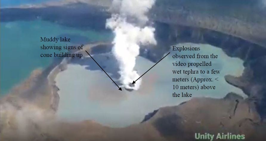
The volcanic activity on Ambae has slightly increased in the minor unrest level, consistent with the Volcanic Alert Level 1. Since 5th of December 2021, the volcano activity consists of emission of steam, with an average height of approximately 250m, and explosions of wet tephra ejected above the lake surface (approximately < 10m),. New analyses suggest that the volcano activity is likely to continue at this level of minor unrest. Volcanic hazards remain at the summit area and creeks (e.g., remobilization of remaining ash from 2017 and 2018 eruption).
Update on Yasur volcano activity issued by the Vanuatu Meteorology and Geohazards Department on 27th November 2021 at 6:30 pm:
The activity of Yasur volcano at the major unrest state is continuing with ongoing volcanic gases and/or ashes emission. The Volcanic Alert Level remains at Level 2.
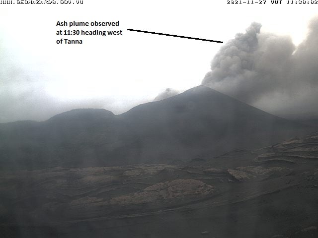
The level of risk for visitors accessing areas within the Danger Zone A (Areas around the crater rim to the parking) REMAIN HIGH. Areas and villages located close to the volcano may continue to expect volcanic gases impacts and/or ash falls following wind directions (currently light east to southeast wind Directions).
Source et photos : Geohazard .
Spain / La Palma , Cumbre Vieja :
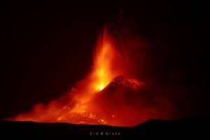
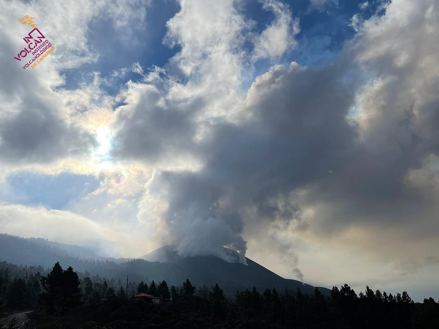
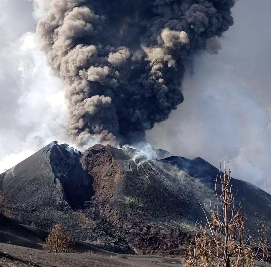
December 13, 2021, 09:00 UTC. Eruptive activity continues on La Palma.
Since the last declaration, a total of 15 earthquakes have been located on the island of La Palma, none of them have been felt by the population.
The maximum recorded magnitude is 3.0 (mbLg), corresponding to today’s earthquakes at 3:38 a.m. and 6:22 a.m. UTC, at a depth of 46 and 37 km, respectively.
Seismicity continues under the central area of Cumbre Vieja in the same areas of the previous days, most of the earthquakes (13) are located at depths between 8 and 15 km, the rest (only 2) were located at depths between 37 and 46 km. No earthquake was located at depths less than 8 km.
The amplitude of the tremor signal increased dramatically, with many intensifying pulses.
The island’s network of permanent GNSS stations does not show a clear trend in the deformation of the stations closest to the eruptive centers.
In the rest of the stations, the slight deflation possibly linked to the deep seismicity has stabilized, except in LP01 which continues to record it.
In view of the image calibrated at 08:45 UTC, an eruptive column height of 4,200 m is estimated with a south-easterly direction.
The height of the cone is measured by obtaining a value of 1,123 m at sea level.
The General Directorate of Security and Emergencies of the Government of the Canary Islands on Monday warned that the air quality is extremely unfavorable in Los Llanos de Aridane, El Paso and Tazacorte, on the island of La Palma, due to Sulfur dioxide (SO2) levels derived from the eruption of the Cumbre Vieja volcano. In these three municipalities, it is detailed in a press release, that the levels of 750 ug / m3 per hour of sulfur dioxide are exceeded.
The most active flows circulate in the central zone with an average flow. There has been an overflow in the Las Norias area that is invading previously uncovered land. Feeding to the main lava delta in the Las Hoyas region continues.
The weather conditions and the orientation of the volcanic plume will favor the operation of La Palma airport during this afternoon.
In the early hours of the morning, the orientation is expected to take a south-easterly direction and may affect the operation from tomorrow.
The lockdown declared yesterday morning for the municipalities of Los Llanos de Aridane, El Paso and Tazacorte has already been lifted after improving air quality. Currently, in the rest of the stations, the levels remain good.
The Cumbre Vieja volcano in La Palma again showed during the afternoon of Monday a Strombolian-type activity with the expulsion of pyroclasts and a column of smoke nearly 4,000 meters high, as detailed by AMETSE (South East Meteorological Agency).
Sources : IGN es , El Pais .
Photos : Involcan , IGME1849 via Patrice Zwenger .
Peru , Sabancaya :
Analysis period: from December 06, 2021 to December 12, 2021, Arequipa, December 13, 2021.
Alert level: ORANGE
The Geophysical Institute of Peru (IGP) reports that the eruptive activity of the Sabancaya volcano remains at moderate levels, that is to say with the recording of an average of 85 daily explosions, with columns of ash and gas up to 2.2 km altitude above the summit of the volcano and their consequent dispersion. Therefore, for the following days, no significant change is expected in eruptive activity.
The IGP recorded and analyzed the occurrence of 831 earthquakes of volcanic origin, associated with the circulation of magmatic fluids within the Sabancaya volcano. An average of 85 explosions was recorded daily. During this period, Volcano-Tectonic (VT) earthquakes associated with rock fracturing were localized mainly in the Northwest, North, and East of Sabancaya and presented magnitudes between M 1 , 0 and M 2.0.
The monitoring of the deformation of the volcanic structure using GNSS techniques (processed with fast orbits) does not present any significant anomalies. However, in general, an inflation process was observed in the northern sector (around the Hualca Hualca volcano). Visual surveillance made it possible to identify columns of gas and ash up to 2.2 km altitude above the summit of the volcano, which were scattered towards the South, South-West, North-West and North sectors – East of Sabancaya. Satellite recordings have identified the presence of 3 thermal anomalies (maximum value of 30 MW) associated with the presence of a lava body on the surface of the volcano’s crater.
RECOMMENDATIONS
• Keep the volcanic alert level in orange.
• Do not approach within a radius of less than 12 km from the crater.
Source : IGP
Photo : Galeria del Ministerio de Defensa del Perú
New Zealand , White Island :
Whakaari/White Island: Volcanic unrest continues with vent temperature rise . Published: Tue Dec 14 2021 12:10 PM
Volcanic Alert Level remains at 2
Aviation Colour Code remains at Yellow
Data from an observation flight at Whakaari/White Island last week shows a significant increase of the active vent temperature to just over 500°C. The state of moderate to heightened unrest continues.
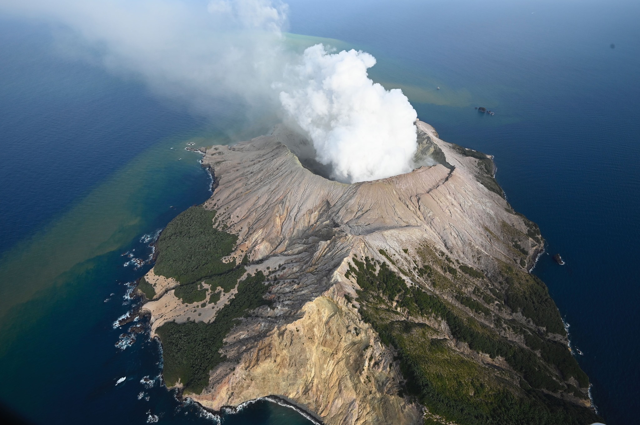
Last week GNS scientists undertook a visual observation flight, including temperature measurements of the active vent area.
The maximum temperature measured in the active vent area was 516°C. During September-November 2021 temperatures ranged from 202°C to 264°C. Temperatures over 500°C were last observed in July-August 2021. These observations are consistent with hot gas continuing to be released from the molten rock (magma) beneath the volcano.
Some minor amount of ash emission continues to be observed, as during most of our previous flights. These ash deposits remain limited to areas close to the active vents. Further intermittent ash emission may continue to occur.
There was no evidence of further ash or liquid emission from the vent near the base of the 2019 landslide area. Gas emissions appeared lower but have not been quantified since 18 November 2021. The water level of the lake has receded during a recent spell of fine weather.

View of the active vent area at Whakaari/White Island on 18 November (left) and 10 December 2021 (right).
The current level of activity is consistent with moderate to heightened levels of unrest. As such the Volcanic Alert Level remains at 2 and the Aviation Colour Code remains at Yellow.
As noted previously, our on-island equipment has degraded. This means that while we are getting some data, it is not real time and it is not complete. We are continuing to work on restoration options.
The Volcanic Alert Level reflects the current level of volcanic unrest or activity and is not a forecast of future activity. While Volcanic Alert Level 2 is mostly associated with volcanic unrest hazards (including discharge of steam and hot volcanic gases, earthquakes, landslides, and hydrothermal activity), potential for eruption hazards also exists and eruptions can still occur with little or no warning.
Source : Geonet /Craig Miller / Duty Volcanologist.
Photos : George Novak , Geonet .
New Zealand , Ruapehu :
Mt Ruapehu status update: Crater Lake (Te Wai ā-moe) is now heating . Published: Tue Dec 14 2021 10:45 AM
Another heating phase has started at Mt Ruapehu and Crater Lake temperature has now reached 31 °C. The Volcanic Alert Level at Mt Ruapehu remains at Level 1.

Typically, over periods of months, Ruapehu’s Crater Lake (Te Wai ā-moe) undergoes heating and cooling cycles.
From early July to early September 2021, the lake temperature rose from 20 °C to 39 °C. Through to mid-October the lake temperature declined to around 23-25 °C. Since early December a heating trend has become established, and the lake temperature is now 31 °C. As is common during these heating phases, small volcanic earthquakes have been recorded since the lake temperature started to rise, caused by an increasing influx of hot steam into the lake.
The modelled heat flow into the lake is currently estimated at about 250 MW (megawatt), up from 50 MW in October/November.
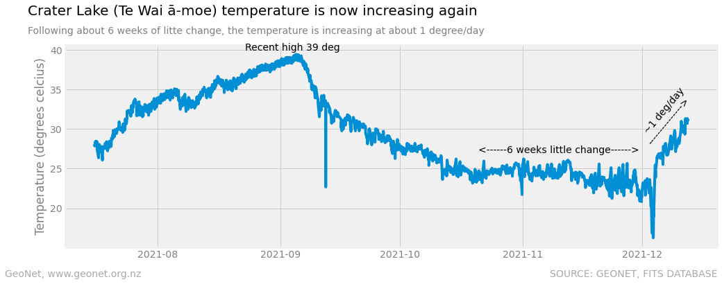
Plot of the daily average Crater Lake temperature as measured at the outlet since July 2021. Short duration spikes in the data are not necessarily representative of the whole lake.
The lake colour is a dark grey colour. This is typical as sediments on the lake floor are disturbed during the influx of hot fluids and are suspended in the lake water. The lake is currently overflowing into the Whangaehu river.
The results from our continuous monitoring of seismic activity, lake temperature and water level indicate that key monitoring parameters remain within normal ranges.
Mt Ruapehu is an active volcano and has the potential to erupt with little or no warning when in a state of volcanic unrest.
Source : Geonet /Craig Miller / Duty Volcanologist.
Photos : GNS/ Bradd Scott , Geonet .