June 26 , 2021.
Italy / Sicily , Etna :
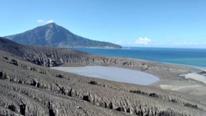
Etna: we don’t stop it anymore …
Press release on ETNA’s activity, June 25, 2021, 02:04 (00:04 UTC).
The National Institute of Geophysics and Volcanology, Osservatorio Etneo reports that from 23:50 UTC today, an increase in Strombolian activity is observed at the level of the Southeast Crater. According to the forecast model, the eruptive cloud produced by the current activity disperses in the east direction.

Press release on ETNA’s activity, June 25, 2021, 03:09 (01:09 UTC).
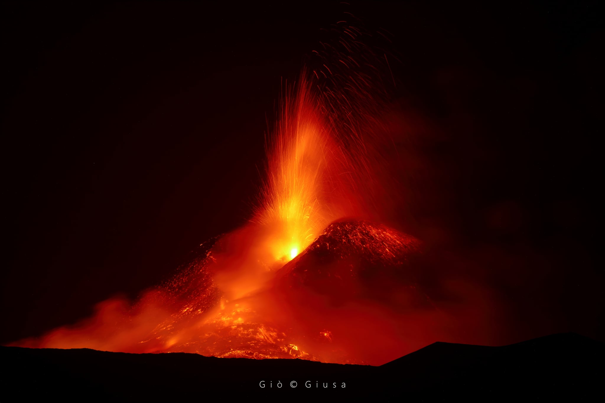
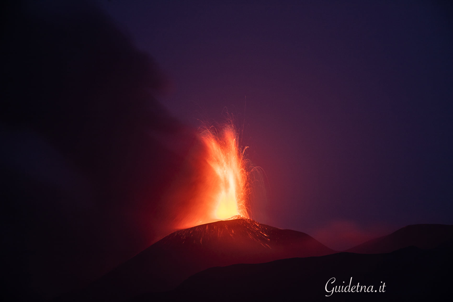
The National Institute of Geophysics and Volcanology, Osservatorio Etneo announces that from approximately 01:00 UTC, from surveillance cameras, it is observed that the Strombolian activity of the Southeast Crater has gradually passed to the fountain stage of lava. Based on the forecast model, the eruptive cloud disperses eastward. The effusive activity produced by the vent at an altitude of about 3050 m remains unchanged.
From 00:20 UTC, the volcanic tremor shows an increase in the growth rate. The locations of the tremor are located in the vicinity of the Southeast Crater around 2700. The infrasound activity is at a high level and is located in correspondence with the Southeast Crater.
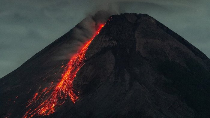
From approximately 01:15 UTC a lava overflow is also observed which, from the southern slope of the Southeast Crater, extends in a southwest direction.

Press release on ETNA’s activity, June 25, 2021, 04:25 (02:25 UTC).
The National Institute of Geophysics and Volcanology, Osservatorio Etneo reports that from 01:48 UTC, the lava fountain of the Southeast Crater has ceased, but weak Strombolian activity remains. The eruptive cloud produced reached a height of about 8.5 km, derived from satellite data and, according to the predicted model, its dispersion concerned the eastern sector of the volcano. Regarding the lava overflow that has spread to the southwest, its front seems to settle at an altitude estimated at around 2900 m above sea level. On the South-East side of the South-East Crater, the lava flow continues from 3050 m. The effusive vent feeds two main lava flows, the most advanced front of which is located at an altitude estimated at about 2700 m above sea level.
After its maximum amplitude at 01:30 UTC, the volcanic tremor began a rapid descent still ongoing. The sources of the volcanic tremor are located near the Southeast Crater at about 2800 m altitude.
The infrasound activity is very high and localized to the Southeast Crater.
During the lava fountain phase, the stations of the inclinometric network recorded modest variations. No significant change is observed in the signals acquired by the GNSS network.

Press release on ETNA’s activity, June 25, 2021, 13:53 (11:53 UTC).
The National Institute of Geophysics and Volcanology, Osservatorio Etneo announces that from the analysis of the images of the surveillance cameras, it is observed that the lava overflow that has spread on the southern slope of the Southeast Crater towards the southwest is more fed and cools. The front remained confined to an altitude of about 2900 m. With regard to the effusive activity fed by the vent open on the South-East side of the South-East Crater at an altitude of about 3050 m above sea level, the more advanced front of the two lava flows, which is are dumped in the upper sector of the Valle del Bove, at 03:30 UTC, was at an estimated altitude of about 2550 m, gradually extending due to the decrease in the slope of the slope. The front of the second stream reached an estimated altitude of about 2700 m.
At 04:15 UTC, a third lava flow formed further north with a front reaching an altitude of about 2800 m. An inspection is underway by the staff of the INGV Etneo Observatory to better locate the aforementioned flows. As of 07:30 UTC, the lava field in the distal zone gradually appeared less and less fueled and is currently cooling.
In addition, with reference to the dispersion of the eruptive cloud attributable to the last lava fountain episode, a fall of ash and lapilli is reported in Fiumefreddo and ash in the locality of Letojanni.
Further updates will be communicated shortly.
And it continues …
Press release on ETNA’s activity, June 25, 2021, 20:26 (18:26 UTC).
The National Institute of Geophysics and Volcanology, Osservatorio Etneo, announces that from approximately 18:05 UTC, an increase in Strombolian activity is observed at the level of the Southeast Crater. Based on the forecast model, the eruptive cloud produced by the current activity disperses in an East-South-East direction. At 18:10 UTC the amplitude of the volcanic tremor is on high values with an increasing trend. The last tremor location, at 17:45 UTC, is near Southeast Crater at a depth of approximately 3.0 km.
The number of infrasound events in the last 10 minutes at 18:07 UTC is high.
The last infrasound event is located near the Southeast Crater.
At present, no significant change is observed in the signals of inclinometer and GNSS networks.
At around 18:25 UTC, an overflow of lava was also observed which, from the southern slope of the Southeast Crater, spreads in a southwest direction.
From approximately 18:40 UTC, the transition of Strombolian activity from the Southeast Crater to the lava fountain stage can be observed from surveillance cameras. Based on the forecast model, the eruptive cloud disperses eastward. Currently, the height of the eruptive column has reached about 7 km above sea level.
At 18:40 UTC the amplitude of the volcanic tremor is on very high values with an increasing trend.
The number of infrasound events is high.
Press release on ETNA’s activity, 25 June 2021, 21:46 (19:46 UTC).
The National Institute of Geophysics and Volcanology, Osservatorio Etneo, reports that as of 7:15 p.m. UTC, the lava fountain in the Southeast Crater gradually ran out. In accordance with the forecast model, the dispersion concerned the eastern sector of the volcano. The eruptive cloud reached a height, derived from satellite data, of about 7.6 km. The staff of the INGV Osservatorio Etneo reports abundant fallout of lapilli up to 5-6 mm on the locality of Santa Tecla. In addition, the lava fountain produced an overflow of lava along the southern slope of the Southeast Crater, which spread in a southwest direction. On the east side, the third lava flow generated by the effusive vent at an altitude of 3050 m above sea level, during the last fountain episode, can still be observed.
The latter appears poorly fed and cooling. At 19:00 UTC the amplitude of the tremor reached maximum values and then began to decrease rapidly. The last locations of the tremor are near the Southeast Crater at an altitude of about 2800 m.
The infrasound activity is at a high level located in the Southeast Crater. During the lava fountain phase, the stations of the inclinometric network recorded modest variations. No significant change is observed in the signals acquired by the GNSS network.
Further updates will be communicated shortly
Source : INGV.
Photos : Gio Giusa , Boris Behncke , Giuseppe Distefano / Marco Restivo , Gio Giusa , Guide Alpine Vulcanologiche Etna .
Indonesia , Merapi :
VOLCANO OBSERVATORY NOTICE FOR AVIATION – VONA.
Issued : June 24 , 2021
Volcano : Merapi (263250)
Current Aviation Colour Code : ORANGE
Previous Aviation Colour Code : orange
Source : Merapi Volcano Observatory
Notice Number : 2021MER03
Volcano Location : S 07 deg 32 min 31 sec E 110 deg 26 min 31 sec
Area : Special Region of Yogyakarta, Indonesia
Summit Elevation : 9498 FT (2968 M)
Volcanic Activity Summary :
Eruption with volcanic ash cloud at 21h44 UTC (04h44 local). Eruption has stopped.
Volcanic Cloud Height :
Best estimate of ash-cloud top is around 12698 FT (3968 M) above sea level, may be higher than what can be observed clearly. Source of height data: ground observer.
Other Volcanic Cloud Information :
Wind direction to southeast.
Remarks :
Pyroclastic density current was recorded in seismogram with max amplitude 75 mm and duration 61, 132, 245 s.
Mount Merapi Activity Report, June 18-24, 2021.
I. RESULTS OF OBSERVATIONS
Visual
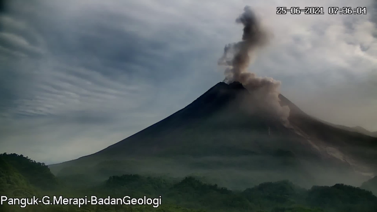
The weather around Mount Merapi is generally sunny in the morning and evening, while it is foggy in the afternoon. White, weak to thick, low pressure, 600m high smoke was observed from the Mount Merapi de Selo observation post on June 20, 2021 at 5:40 a.m. WIB.
This week, hot cloud avalanches have occurred 17 times with a maximum slide distance of 2,500 m to the Southwest and 5 times with a slide distance of 1,400 m to the Southeast. Lava avalanches have been observed 206 times with a maximum slide distance of 2,000 meters to the southwest and 600 m to the southeast.
On June 25, 2021 at 04:43 WIB, there were 3 hot cloud avalanches, with a maximum slide distance of 3 km to the southeast and a smoke column reaching 1000 m above the summit was observed. The hot avalanche clouds caused ash rains in several areas of the south-eastern sector of Mount Merapi.
The volume of the lava dome in the southwest sector is 1,590,000 m3 with a growth rate of 11,400 m3 / day. Morphological analysis of the summit area based on photos of the Southeast sector from June 17 to June 24, 2021 shows an increase in the height of the central dome of 0.5 m.
Seismicity
This week, the seismicity of Mount Merapi recorded
22 hot avalanche clouds (AP),
59 shallow volcanic earthquakes (VTB),
362 multi-phase earthquakes (MP),
1325 Avalanche earthquakes (RF),
122 emission earthquakes (DG)
11 tectonic earthquakes (TT).
This week’s seismicity intensity was higher than last week.
Deformation
The deformation of Mount Merapi, which was monitored using EDM this week, showed a distance shortening rate of 2cm / day.
Rain and lahars
This week, it rained at the Mount Merapi observation post with an intensity of 41 mm / hour for 60 minutes at the Ngepos post on June 20, 2021. There were no reports of lahars or additional flow in the mountains. rivers that take their source on Mount Merapi.
Conclusion
Based on the results of visual and instrumental observations, it is concluded that:
The volcanic activity of Mount Merapi is still quite high in the form of effusive eruption activity. The status of the activity is defined in the “SIAGA” level.
Source : Magma Indonésie , BPPTKG.
Photos : ANTARA FOTO/Hendra Nurdiyansyah , Bpptkg.
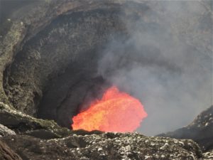
Italy , Stromboli :
Press release on STROMBOLI’s activity, June 25, 2021, 17:21 (15:21 UTC).
The National Institute of Geophysics and Volcanology, Osservatorio Etneo, announces that as of 14:25 UTC, surveillance cameras show the start of a small lava overflow from the North Crater area in conjunction with the activity of splashing from two mouths of this sector of the crater area. At present, the lava flow front has advanced about 100 m. The displacement of the flow causes the occasional rolling of boulders along the slope of the Sciara del Fuoco. From a seismic point of view, no significant variation is demonstrated. The average tremor level is currently at its lowest for seven days. Regarding the deformations, no significant variation is observed in the signals recorded on the inclinometric and GNSS networks.

At approximately 11:19 pm (21:19 UTC), the lava overflow from the North Crater area, reported in the previous Advisory, had depleted and cooled. In the hours that have passed since the previous press release, the volcanic tremor has been steadily increasing while remaining at relatively low levels.
Further updates will be communicated shortly.
Source : INGV.
Photo : Stromboli stati d’animo
Ecuador , Reventador :
DAILY REPORT OF THE STATE OF THE REVENTADOR VOLCANO, Friday June 25, 2021.
Information Geophysical Institute – EPN.
Surface activity level: High, Surface trend: No change.
Internal activity level: Moderate, Internal trend: No change.
Seismicity: From June 24, 2021, 11: 00h to June 25, 2021, 11: 00h:
Explosions (EXP): 83 events
Long period type events (LP): 75
Emission tremor (TREMI): 15
Harmonic tremor (TRARM): 3
Rains / lahars: Light rains were recorded in the volcano region, without generating lahars.
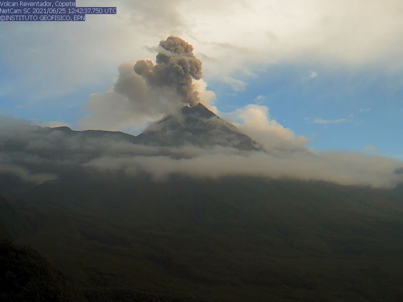
Emission / ash column: Yesterday evening and early today, several ash emissions were observed towards the West and North-West, with heights around 800 and 1000 meters above crater level. The Washington VAAC reported 4 alerts of emissions observed by the satellites, their direction was maintained in the Northwest and the heights did not exceed 1000 meters above the level of the crater.
Other monitoring parameters: FIRMS logs 4 thermal alerts on the Reventador in the last 24 hours.
Observations: There are no reports
Alert level: Orange.
Source et photo : IGEPN
Guatemala , Santiaguito :
ACTIVITY:
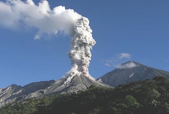
The webcam and the seismic station Stg8 record and observe the activity of the crater with weak explosions and some moderate, accompanied by columns of ash at 2800 meters above sea level. (9186 feet) dispersing 8 kilometers west, southwest. Ash falls are noted in the villages of Loma Linda and San Marcos Palajunoj. The lava extrusion into the crater is maintained, forming promontories that descend in the form of avalanches on the western and southern flanks.
Due to unstable materials in the crater, there is a probability of generating moderate to strong pyroclastic flows, which is why one should not stay near or in the river beds near the slopes of the volcano. Moderate and heavy rains continue in the afternoon and evening, with the likelihood of continuing to generate lahars through the channels of the Nimá I, Nimá II, Tambor rivers, tributaries of the Samalá river, therefore it is recommended to take precautions.
Source : INSIVUMEH
Photo : La Hora