June 30 , 2024.
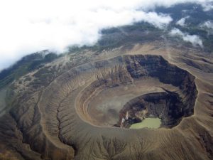
Italy / Sicily , Etna :
Press release on the activity of Etna, June 29, 2024, 7:14 p.m. (5:14 p.m. UTC).
The National Institute of Geophysics and Volcanology, Osservatorio Etneo, communicates that the INGV personnel, present in the summit area, report the emission of an intra-crater lava flow which, in the Voragine crater, flows inside the Bocca Nuova crater, and in particular inside the BN2 pit. At the same time, weak Strombolian activity continues in the Voragine crater, which began on June 13 and 14, causing the launch of pyroclastic materials inside the crater depression.
The average amplitude of the volcanic tremor, after a gradual increase observed from the afternoon of June 23, is currently at medium-high values. The center of gravity of the source is located in the Southeast crater area, at an altitude of approximately 2.5 km above sea level. Infrasound activity is weak and the sources of the events are essentially located in the Southeast crater.
the frequency of appearance of infrasound events and their location may have been influenced by the high noise due to the presence of strong winds at altitude which characterized the week.
Concerning ground deformations, no significant changes were recorded in the monitoring networks.
Further updates will be communicated shortly.
Source : INGV
Photo : Gio Giusa
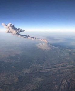
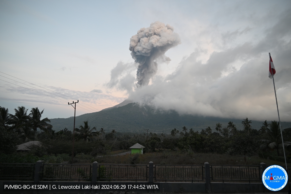
Indonesia , Lewotobi Laki-laki :
An eruption of Mount Lewotobi Laki – Laki occurred on Saturday June 29, 2024 at 5:41 p.m. WITA with the height of the ash column observed at ± 900 m above the summit (± 2484 m above sea level ). The ash column was observed to be gray with thick intensity, oriented towards the South-West and West. This eruption was recorded on a seismograph with a maximum amplitude of 47.3 mm and a duration of 275 seconds.
VOLCANO OBSERVATORY NOTICE FOR AVIATION – VONA
Issued : June 29 , 2024
Volcano : Lewotobi Laki-laki (264180)
Current Aviation Colour Code : ORANGE
Previous Aviation Colour Code : orange
Source : Lewotobi Laki-laki Volcano Observatory
Notice Number : 2024LWK138
Volcano Location : S 08 deg 32 min 20 sec E 122 deg 46 min 06 sec
Area : East Nusa Tenggara, Indonesia
Summit Elevation : 5069 FT (1584 M)
Volcanic Activity Summary :
Eruption with volcanic ash cloud at 09h41 UTC (17h41 local).
Volcanic Cloud Height :
Best estimate of ash-cloud top is around 7949 FT (2484 M) above sea level or 2880 FT (900 M) above summit. May be higher than what can be observed clearly. Source of height data: ground observer.
Other Volcanic Cloud Information :
Ash cloud moving from southwest to west. Volcanic ash is observed to be gray. The intensity of volcanic ash is observed to be thick.
Remarks :
Eruption recorded on seismogram with maximum amplitude 47.3 mm and maximum duration 275 second.
Source et photo : Magma Indonésie
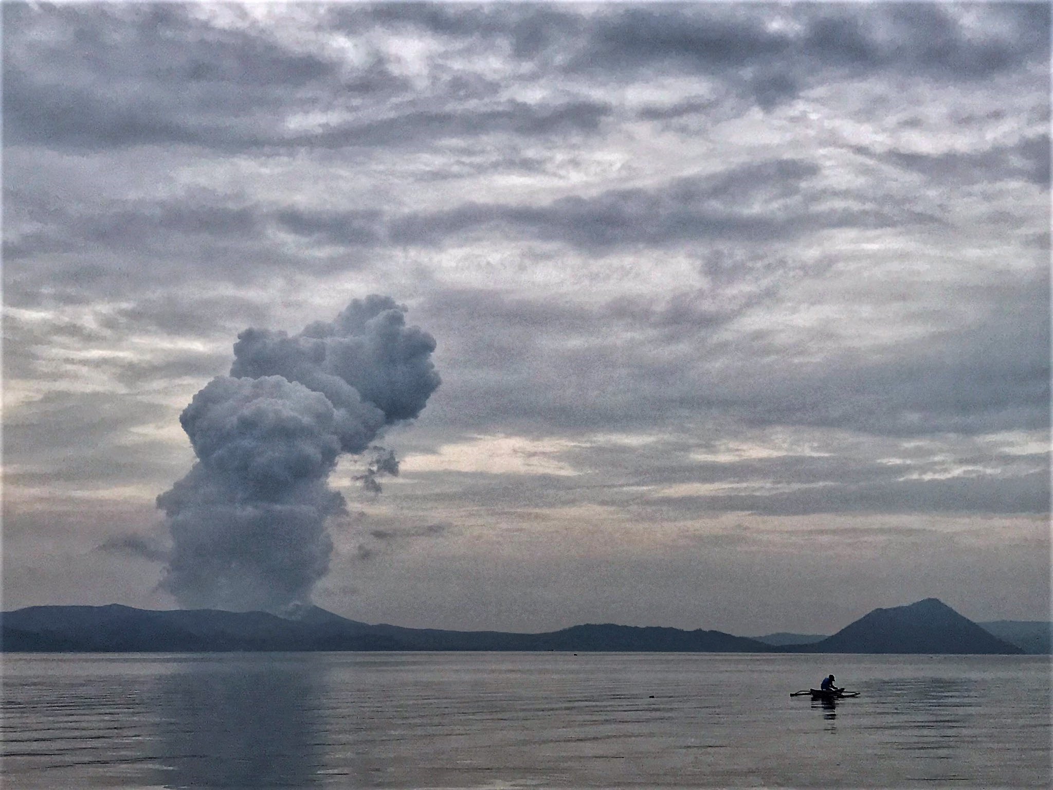
Philippines , Taal :
TAAL VOLCANO ADVISORY 29 June 2024 3:45 PM
Notice of weak phreatic activity at Taal Volcano.
Two (2) weak phreatic or steam-driven events at the Taal Main Crater occurred today, 29 June 2024, at 2:31 PM and 2:39 PM and lasted a minute each based on visual, seismic and infrasound records of the Taal Volcano Network (TVN). The events produced steam-laden plumes that rose 800 meters above the Main Crater before drifting southwest based on IP camera monitors. Sulfur dioxide (SO2) emissions averaged 6,571 tonnes/day on 28 June 2024. Nonetheless, average SO2 emissions since January this year remain high at 7,895 tonnes/day. Weak phreatic activity is likely driven by the continued emission of hot volcanic gases at the Taal Main Crater and could be succeeded by similar events. The background levels of volcanic earthquake activity and ground deformation detected at Taal indicate that unrest is unlikely to progress into magmatic eruption.
DOST-PHIVOLCS reminds the public that Alert Level 1 prevails over Taal Volcano, which means that it is still in abnormal condition and should not be interpreted to have ceased unrest nor ceased the threat of eruptive activity. At Alert Level 1, sudden steam-driven or phreatic explosions, volcanic earthquakes, minor ashfall and lethal accumulations or expulsions of volcanic gas can occur and threaten areas within the Taal Volcano Island (TVI). Furthermore, degassing of high concentrations of volcanic SO2 continues to pose the threat of potential long-term health impacts to communities around Taal Caldera that are frequently exposed to volcanic gas. DOST-PHIVOLCS strongly recommends that entry into TVI, Taal’s Permanent Danger Zone or PDZ, especially the vicinities of the Main Crater and the Daang Kastila fissure, must remain strictly prohibited. Local government units are advised to continuously monitor and assess preparedness of their communities and undertake appropriate response measures to mitigate hazards that could be posed by long-term degassing and related phreatic activity. Civil aviation authorities must advise pilots to avoid flying close to the volcano as airborne ash and ballistic fragments from sudden explosions and wind-remobilized ash may pose hazards to aircrafts.
DOST-PHIVOLCS is closely monitoring Taal Volcano’s activity and any new significant development will be immediately communicated to all stakeholders.
Source : Phivolcs
Photo : Rizal M ( archive)
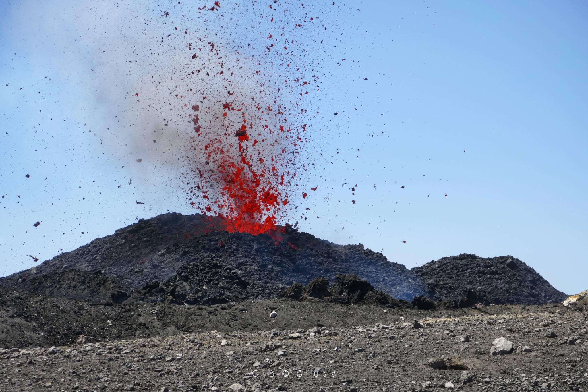
Colombia , Puracé :
Popayan, June 29, 2024, 2:30 p.m.
Regarding the monitoring of the activity of the PURACE VOLCANO – LOS COCONUCOS VOLCANIC RANGE, the COLOMBIAN GEOLOGICAL SERVICE (SGC), an entity attached to the MINISTRY OF MINES AND ENERGY, reports that:
As of yesterday and up to the time of publication of this bulletin, seismic activity associated with fracture and fluid processes remains at levels similar to those observed for weeks.
previous ones. The locations of fracture earthquakes continue to be located mainly under the Puracé volcano, both in the crater and on the western flank, at depths between 1 and 3 km. Fluid earthquakes, for their part, remain localized under the crater of the Puracé volcano at a maximum depth of 1 km.
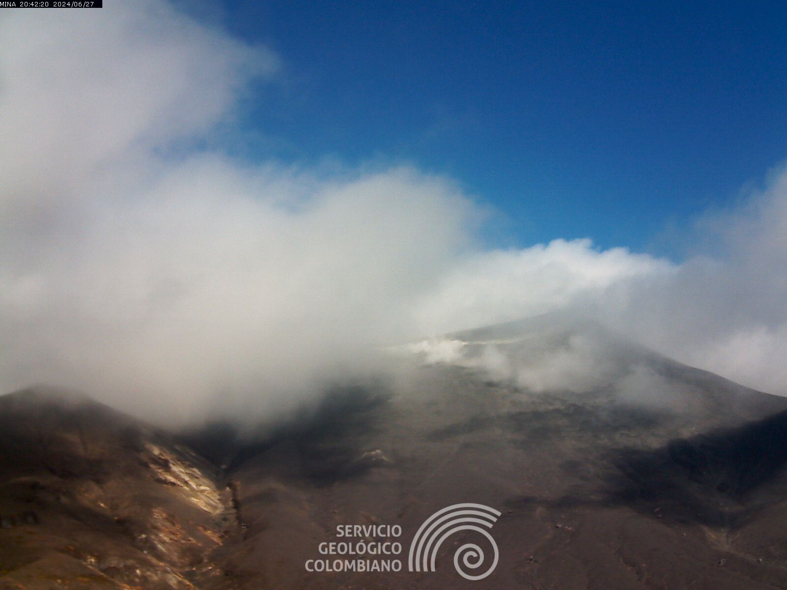
During this morning it was possible to observe through the images obtained by the webcams the degassing processes in the lateral fumarole and in the crater, which continue to be characterized by their white color and their dispersion according to the direction of the winds in the area. The height of the gas column was estimated at 774 m measured from the summit of the volcano. On the other hand, the process of ground deformation and the concentrations of carbon dioxide (CO2) and sulfur dioxide (SO2) gases maintain the observed trend, with values that remain above the known baselines for this volcano.
The SGC confirms that the alert state of the PURACE VOLCANO continues at ORANGE: volcano with significant changes in the monitored parameters.
Source et photo : SGC
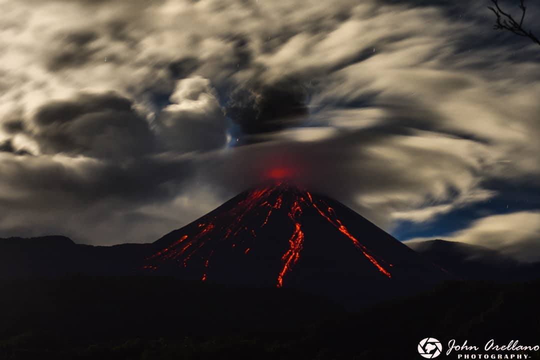
Ecuador , Reventador :
DAILY REPORT ON THE STATE OF THE REVENTADOR VOLCANO, Saturday June 29, 2024.
Information Geophysical Institute – EPN.
Surface activity level: High, Surface trend: No changes
Internal activity level: Moderate, Internal trend: No changes
Seismicity: From June 8, 2024, 11:00 a.m. to June 9, 2024, 11:00 a.m.:
Seismicity:
Below is the count of seismic events recorded at the reference station
Explosion (EXP) 96
Long Period (LP) 29
Transmitting Tremor (TREMI) 14
Harmonic Tremor (TRARM) 9
Precipitation/Lahars:
No rain was recorded in the volcano area. **In the event of heavy rains, these could remobilize the accumulated materials, generating mud and debris flows which would descend the sides of the volcano and flow into adjacent rivers.
Emissions/ash column:
Due to poor weather conditions, it was not possible to observe gas and ash emissions through the surveillance camera system; However, using satellite images, a broadcast was recorded that had a height of 800 meters above the level of the crater and was heading west. In connection with this activity, the Washington VAAC reported two emissions with heights between 800 and 1,100 meters above the level of the crater in the west direction.
Other monitoring parameters:
Over the past 24 hours, the FIRMS satellite system recorded 6 thermal anomalies, while the MIROVA-MODIS system recorded 1 thermal anomaly and the MIROVA-VIIRS system recorded 1 thermal anomaly.
Observation:
During the night yesterday and early today, several descents of incandescent material were observed along the flanks of the volcano, up to 800 meters below the level of the crater. At the end of this report, the volcano remains cloudy.
Alert level: Orange
Source : IGEPN.
Photo : John Arellano ( archive)