June 22 , 2024
Indonesia , Ibu :
Reduction of G. Ibu activity level from level IV (AWAS) to level III (SIAGA).
The results of the assessment of G. Ibu activity in the North Moluccas province are presented as follows
I. Visual surveillance
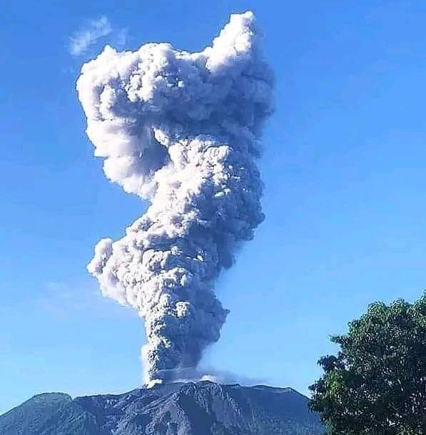
Visual observations of Mount Ibu for the period June 1-20, 2024 showed that the volcano was clearly visible until it was covered by fog. Smoke from the main crater was observed white, gray, brown and black in color with thin, medium to thick intensity at a height of approximately 100 to 7,000 meters above the summit.
II. Instrumental observation
Seismicity:
During the period June 1-20, 2024, records were dominated by shallow volcanic earthquakes, eruption earthquakes, emissions earthquakes, and deep tectonic earthquakes that still produce every day.
During this period, it was recorded:
52 eruption earthquakes
2 avalanche earthquakes,
1,351 emissions earthquakes
192 harmonic tremors,
13 non-harmonic tremors,
5 Tornillo-type earthquakes
14,681 superficial volcanic earthquakes
852 deep volcanic earthquakes,
27 times local tectonic earthquakes,
1 earthquake felt (MMI II scale)
284 Distant tectonic earthquakes.
III. Assessment
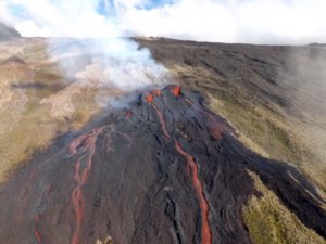
On June 1 and 2, 2024, visual activity and seismicity, especially deep volcanic earthquakes and shallow volcanic earthquakes, were still high. A series of intense earthquakes at shallow depths were recorded, indicating an increase in pressure due to the migration of magma to shallow depths. The height of the eruptive column also increased to 7,000 meters from the summit crater. The eruption was accompanied by ejections of incandescent lava reaching a radius of approximately 2 km from the crater rim, accompanied by roars and rumbles that could be heard as far away as the PGA Post.
From June 15, 2024, the number of recorded earthquakes and the height of the eruptive column began to decrease. Eruption events accompanied by ejections of incandescent lava also began to decrease, and the distance of the ejections also shortened, i.e. within a radius of 1 km from the edge of the crater.
Based on field observations, potential hazards that may arise are glowing lava ejections, hot eruption clouds (if the lava dome is destroyed or dismantled), hot avalanche clouds (if the eruption material accumulated on the crater rim is unstable) and lava flows which were observed in the river which passes through the village of Togarebasungi, the village of Todoke, the village of Barona, the village of Naga, the village of Togowo and the village of Togerebotua.
IV. Recommendation
Based on the results of visual and instrumental monitoring which show a decrease in volcanic activity on Mount Ibu, the activity level of Mount Ibu was lowered from level IV (AWAS) to level III (SIAGA) from from June 21, 2024 at 12:00 WIT.
Source : PVMBG
Photo : Lexi Djangu Trekker ( archive)
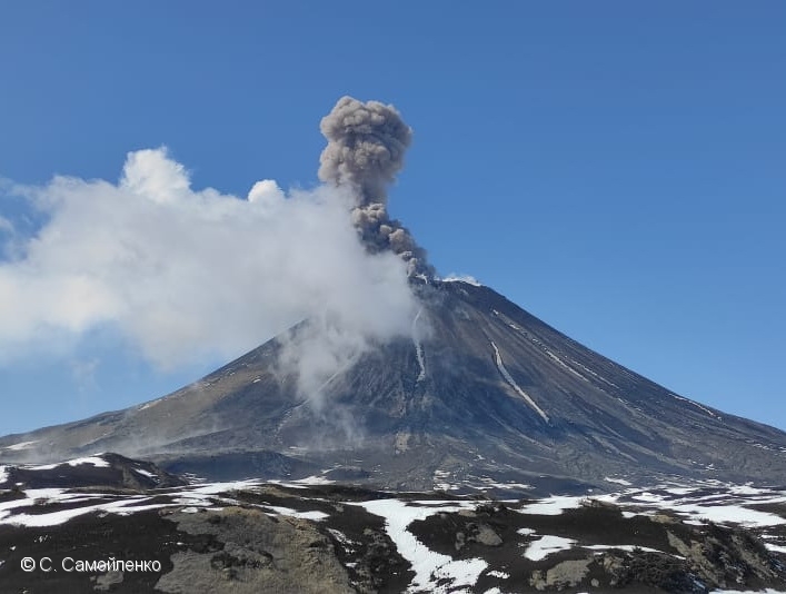
Kamchatka , Karymsky :
VOLCANO OBSERVATORY NOTICE FOR AVIATION (VONA)
Issued: June 21 , 2024
Volcano: Karymsky (CAVW #300130)
Current aviation colour code: ORANGE
Previous aviation colour code: orange
Source: KVERT
Notice Number: 2024-29
Volcano Location: N 54 deg 2 min E 159 deg 26 min
Area: Kamchatka, Russia
Summit Elevation: 1486 m (4874.08 ft)
Volcanic Activity Summary:
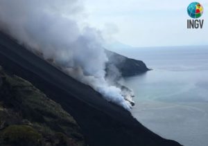
Satellite data by KVERT showed explosions sent ash 3 km a.s.l. from the Karymsky volcano, and an ash cloud is drifting about 30 km to the west of the volcano.
A moderate explosive activity of the volcano continues. Ash explosions up to 10 km (32,800 ft) a.s.l. could occur at any time. Ongoing activity could affect international and low-flying aircraft.
Volcanic cloud height:
3000 m (9840 ft) AMSL Time and method of ash plume/cloud height determination: 20240621/2200Z – Himawari-9 14m15
Other volcanic cloud information:
Distance of ash plume/cloud of the volcano: 30 km (19 mi)
Direction of drift of ash plume/cloud of the volcano: W / azimuth 271 deg
Time and method of ash plume/cloud determination: 20240621/2310Z – Himawari-9 14m15
Remarks:
Last eruption of the Karymsky volcano occurred from 2021/4/3 till 2022/8/22. New eruption began on 20 June. 2024.
Source : Kvert
Photo : S. Samoylenko
Alaska , Shishaldin :
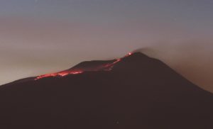
Low-level unrest continues at Shishaldin Volcano, with occasional small volcanic earthquakes and weak seismic tremor observed throughout the week. Very weak explosive activity was detected in local infrasound data during a period of optimal environmental conditions. Steam and sulfur dioxide gas emissions were observed in satellite data on several days over the past week. These observations are typical of Shishaldin during this post-eruption period of unrest.
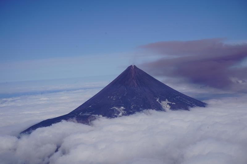
Minor rock falls associated with collapse events from the unstable ground in and near the summit crater may generate small clouds of fine-grained dust that dissipate quickly near the summit. No significant eruptive activity has occurred since November 2023.
Local seismic and infrasound sensors, web cameras, and a geodetic network are used to monitor Shishaldin Volcano. In addition to the local monitoring network, AVO uses nearby geophysical networks, regional infrasound and lighting data, and satellite images to monitor the volcano.
Source : AVO
Photo : Tan, Darren / AVO/University of Alaska Fairbanks, Geophysical Institute
Hawaii , Kilauea :
Friday, June 21, 2024, 8:23 AM HST (Friday, June 21, 2024, 18:23 UTC)
19°25’16 » N 155°17’13 » W,
Summit Elevation 4091 ft (1247 m)
Current Volcano Alert Level: ADVISORY
Current Aviation Color Code: YELLOW
Activity Summary:
Kīlauea volcano is not erupting. Earthquake counts and rates of inflationary ground deformation in the summit and upper rift zones continue the slightly elevated behavior since the end of the June 3 eruption. Increases in seismicity and/or deformation could result in new eruptive episodes within or near the summit region.
Recent Eruption Site Observations:
Kīlauea erupted briefly on Monday, June 3, southwest of Kaluapele (Kīlauea caldera) within a closed area of Hawai’i Volcanoes National Park. Glow from fissure vents is no longer visible in webcam imagery. Seismic activity remains low beneath the eruption site. SO2 emissions from the eruption site have likely decreased since the most recent measurement of less than 350 tonnes per day on June 10, 2024. Current gas emissions are likely to be similar to background emission levels at the summit, which are 50-100 tonnes per day. Conditions make it difficult to accurately measure the output from the June 3 vents. Local SO2 concentrations within and nearby the vents may remain very high.

Summit and Upper Rift Zone Observations:
Rates of seismicity beneath the summit and the upper East Rift Zone had sixty-four earthquakes over the past 24 hours, mostly beneath the south caldera region at depths of 1.5-3 km (1–1.8 miles), with magnitudes under M2.5. Ground deformation data at the summit shows resumed steady inflation. The Uēkahuna tiltmeter northwest of the summit levelled increased over the past 24 hours. The Sand Hill tiltmeter southwest of the summit recorded approximately 5 microradians of inflation over the past 24 hours. The most recent summit SO2 emission rate measured was approximately 50 t/d on June 10, 2024; accordingly, total SO2 emissions from the summit and recent eruption site are likely less than 200 t/d.
Lower Rift Zone Observations:
Rates of seismicity and ground deformation beneath the middle and lower East Rift Zone and lower Southwest Rift Zone are low. Eruptive activity and unrest have been restricted to the summit and upper rift zone regions. Measurements from continuous gas monitoring stations downwind of Puʻuʻōʻō in the middle East Rift Zone remain below detection limits for SO2, indicating that SO2 emissions from Puʻuʻōʻō are negligible.
Source : HVO
Photo : USGS/ M. Patrick.
Colombia , Puracé :
Popayan, June 21, 2024, 2:00 p.m.
Regarding the monitoring of the activity of the PURACE VOLCANO – LOS COCONUCOS VOLCANIC RANGE, the COLOMBIAN GEOLOGICAL SERVICE (SGC), an entity attached to the MINISTRY OF MINES AND ENERGY, reports that:
Until the time of publication of this bulletin, seismic activity remained at levels similar to those recorded in previous days, both in number of events and in seismic energy released, a behavior observed both for the seismicity of fractures than fluids. The earthquakes associated with the fracturing of rocks were located under the building of the Puracé volcano, at depths between 1 and 3 km; Fluid seismicity, for its part, continues to be located mainly below the crater of the Puracé volcano, in a depth range of less than 1 km.
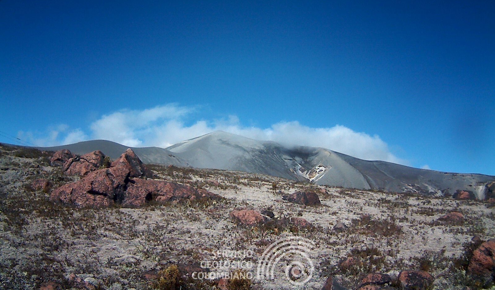
In the images obtained up to the time of publication of this bulletin, it was not possible to have a clear view of the crater.
Ground deformation processes and the concentrations of carbon dioxide (CO2) and sulfur dioxide (SO2) gases maintain the observed trend, with values that remain above the known baselines for this volcano.
The SGC confirms that the alert state of the PURACE VOLCANO continues at ORANGE: volcano with significant changes in the monitored parameters.
Source et photo : SGC