May 18 , 2024.
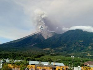
Chile , Villarica :
Seismology
The seismological activity of the period was characterized by the recording of:
A continuous tremor signal associated with the fluid dynamics inside the volcano, which during the period presented an energy variation, evaluated with the RSAM parameter, between 0.9 and 2.4 μm/s, values considered above the base level.
197 seismic events of type VT, associated with the fracturing of rocks (Volcano-Tectonics). The most energetic earthquake had a Local Magnitude (ML) value equal to 2.8, located 7.7 km east-southeast of the volcanic edifice, at a depth of 1.3 km relative to to the crater.
13807 LP type seismic events, associated with fluid dynamics inside the volcanic system (Long Period). The size of the largest earthquake evaluated from the Reduced Displacement (RD) parameter was equal to 75 cm2.
2214 seismic events of type TR, associated with the dynamics maintained over time of fluids inside the volcanic system (TRemor). The size of the largest earthquake evaluated from the Reduced Displacement (RD) parameter was equal to 36 cm2.
Fluid geochemistry
No anomalies have been reported in emissions of sulfur dioxide (SO2) into the atmosphere in the area near the volcano, according to data published by the Tropopheric Monitoring Instrument (TROPOMI) and the Ozone Monitoring Instrument (OMI) Sulfur Dioxide Group.

Geodesy
The analysis of geodetic data, based on data from 5 GNSS stations, indicates that:
– Based on the trends and directions of movement, there is no deformation pattern at the volcanic edifice that suggests relevant changes at depth.
– The horizontal and vertical displacement rates have moderate magnitudes and, in general, their trends correspond to the cyclical variations observed previously, maintaining the trend changes observed during the previous period. The stations located to the east of the volcanic edifice present greater vertical displacements, with rates less than 1 cm/month, while the horizontal ones do not exceed 0.5 cm/month.
– The distance between stations maintains its trend, even if we note a slight increase in the magnitude of the rates between some of them, reaching values of 2.5 cm/year.
Surveillance cameras
From surveillance cameras installed on the volcano, degassing was observed recurrently, with the development of columns of gas visible up to 280 m above the level of the crater on April 21. Most of them had a predominance of water vapor. Occasionally, on April 21 and 24, columns with moderate pyroclastic content were recorded, the maximum height of which reached 100 m above the crater level. Likewise, Strombolian activity was observed on April 17 and 24, with a proximal impact, inside and on the edge of the crater and whose height reached a maximum of 80 m.
Satellite geomorphological analysis
Thanks to the photo-interpretation of Planet Scope Scene and Pléiades satellite images, the permanence of the tephra ring, product of the accumulation of pyroclasts, is recognized inside the crater, resulting from the activity, of a diameter average of 73 m. Inside, the lava lake is observed with sporadic surface variations due to the partial solidification of its surface, estimating an exposed lake surface area of 616 m2.
Activity remained at levels considered moderate, suggesting low stability in the proximal area of the crater. Due to the above, a possible affected area with a radius of 500 meters around the crater is considered.
The technical volcanic alert is maintained in:
YELLOW TECHNICAL ALERT: Changes in the behavior of volcanic activity.
Source : Sernageomin
Photo : in-cyprus.philenews.com/
Indonesia , Semeru :
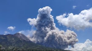
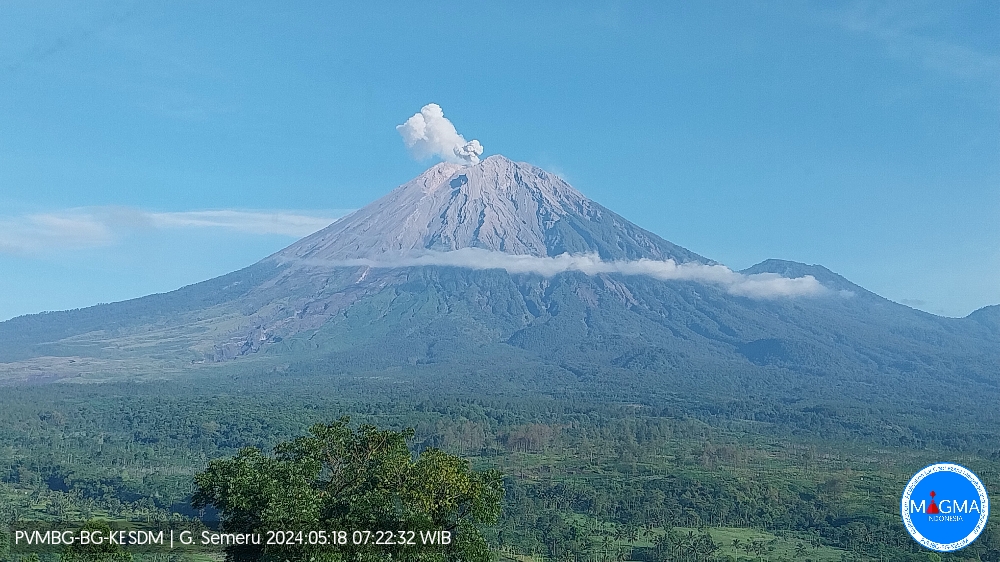
Mount Semeru exhibited an eruption on Saturday, May 18, 2024 at 08:04 WIB with the height of the ash column observed at ± 600 m above the summit (± 4276 m above sea level). The ash column was observed to be white to gray in color with moderate intensity, oriented southwest. At the time of writing, the eruption was still ongoing.
Observation of seismicity
14 eruption earthquakes with an amplitude of 13 to 22 mm and a duration of 70 to 115 seconds.
1 avalanche earthquake with an amplitude of 5 mm and an earthquake duration of 122 seconds.
3 emission earthquakes with an amplitude of 3 to 7 mm and duration of the earthquake from 21 to 51 seconds.
1 harmonic tremor with an amplitude of 5 mm, and an earthquake duration of 218 seconds.
RECOMMENDATION
1. Do not carry out any activities in the South-East sector along Besuk Kobokan, 13 km from the summit (center of the eruption). Beyond this distance, people do not carry out activities within 500 meters of the river bank along Besuk Kobokan as they may be affected by the expansion of warm clouds and downslopes of the river. lahars up to a distance of 17 km from the summit.
2. Do not practice activities within a 5 km radius of the crater/summit of the Mount Semeru volcano as it is subject to the danger of stone throwing (projections).
3. Be aware of the potential for warm avalanche clouds, lahars along the rivers/valleys that originate at the summit of Semeru Volcano, particularly along Besuk Kobokan, Besuk Bang, Besuk Kembar and Besuk Sat, as well as the potential for lahars in small rivers that are tributaries of Besuk Kobokan.
The Semeru volcano in Indonesia’s East Java province erupted five times today, spewing volcanic ash up to 900 meters over its peak, according to the Center for Volcanology and Geological Hazard Mitigation.
« The first eruption was at 6:29 a.m. local time, with a column of white to grey ash as high as 500 meters heading to the southwest, » said Semeru Volcano Monitoring Post officer Liswanto, China’s Xinhua news agency reported.

The second eruption occurred at 6:50 a.m. local time, launching ash as high as 600 meters above its peak, while the third eruption occurred at 7:28 a.m. local time, releasing an ash column as high as 700 meters.
Volcanic ash was thrown up to 500 meters in the fourth eruption and nearly a kilometer (over 900 meters) in the fifth, which happened at 7:57 a.m. and 8:05 a.m. local time, respectively.
Source : Magma Indonésia , NDTV.com.
Photos : PVMBG , IANS.
Hawaii , Kilauea :
Friday, May 17, 2024, 7:45 AM HST (Friday, May 17, 2024, 17:45 UTC)
19°25’16 » N 155°17’13 » W,
Summit Elevation 4091 ft (1247 m)
Current Volcano Alert Level: ADVISORY
Current Aviation Color Code: YELLOW
Activity Summary:
Kilauea volcano is not erupting. Unrest continues beneath Halemaʻumaʻu, the south caldera, and the upper East Rift Zone.
Summit Observations and Upper East Rift Zone Observations:
Earthquake counts remain slightly above background levels. Last night, there was a flurry of earthquakes under the south caldera region. Things have settled down for now. Over the past day, earthquakes have clustered below the summit and upper East Rift Zone. Earthquake depths have averaged 1–3 km (0.6–1.9 miles) beneath the surface, and magnitudes have been mostly below M2.0.
Ground deformation continues beneath Halemaʻumaʻu and the south caldera region. The Uēkahuna tiltmeter northwest of the summit showed overall slight inflationary tilt over the past day. At the same time, the Sand Hill tiltmeter southwest of the summit showed west-northwest inflationary tilt in the south caldera region.
Sulfur dioxide (SO2) gas emission rates remain low. An SO2 emission rate of approximately 62 tonnes per day was recorded on May 2.

A view of Halema‘uma‘u, at the summit of Kīlauea, taken from the southwest caldera rim on May 10, 2024. While seismicity has been elevated in the south caldera and upper East Rift Zone in the past week, nothing unusual was observed on the surface today.
Rift Zone Observations:
Elevated seismic activity in the Upper East Rift Zone is scattered along this zone. Currently, seismicity in Kilauea’s Southwest Rift Zone is relatively low outside the summit region. Measurements from continuous gas monitoring stations downwind of Puʻuʻōʻō in the middle East Rift Zone remain below detection limits for SO2, indicating that SO2 emissions from Puʻuʻōʻō are negligible.
Analysis:
Magma has been pressurizing the system beneath Halemaʻumaʻu and the south caldera region, activating seismicity along faults in the upper East Rift Zone. At this time, it is not possible to say whether this increase in activity will lead to an intrusion or eruption in the near future, or simply continue as seismic unrest at depth. Changes in the character and location of unrest can occur quickly, as can the potential for eruption.
Source : HVO
Photo : USGS/ M. Patrick.
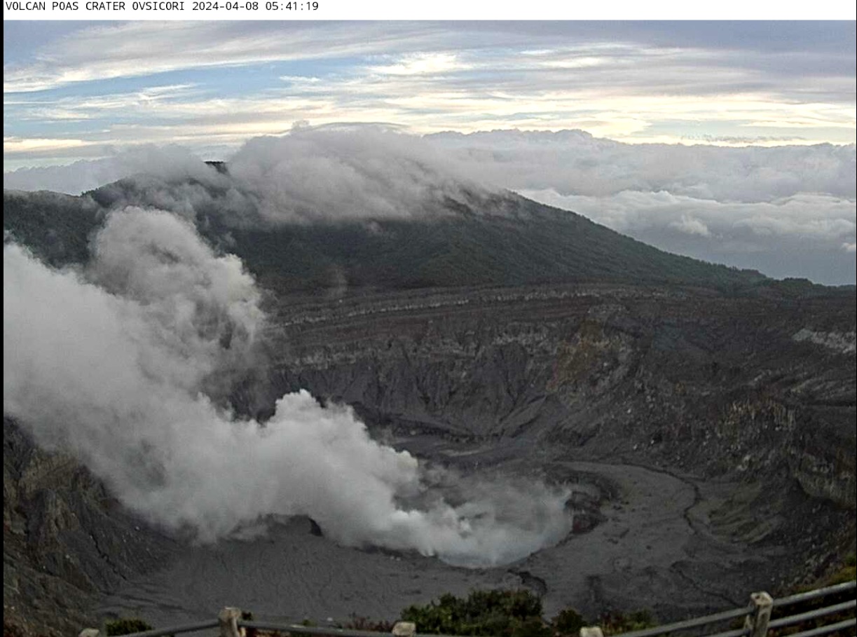
Costa Rica , Poas :
Daily report on the state of volcanoes. Date: May 15, 2024. Updated at: 15:06:00.
Latitude: 10.2
Longitude: -84,233
Altitude: 2,687 meters
Activity observed:
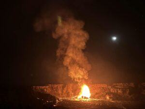
-During the night, a glowing light continues to be observed in fumarole vents A and C at the crater floor due to ignition and combustion of molten sulfur.
-A vigorous plume rich in water vapor, gas, aerosols and a small quantity of ash is dispersed by winds mainly oriented towards the West.
-The volcanic seismic tremor is found at low levels with predominant frequencies around 3 Hz.
-The acoustic tremor is low.
-Sporadic low frequency (LP) seismic events associated with the transport of fluids (water, gas) from the interior of the volcano to the environment are recorded.
-Gas measurements by the MultiGas near real-time detection system on the western edge of the crater remain stable compared to recent weeks: the maximum CO2/SO2 ratio is 0.97 and the H2S/SO2 ratio remains around 0 ,6. The maximum concentration of SO2 is 16 parts per million.
-The concentration of SO2 in the visitors’ view detected by the ExpoGAS gas monitor recorded a maximum of 1.5 parts per million this morning of May 15.
-In recent days we have not received any reports of the smell of sulfur or falling ash from residents near Poás Volcano.
Environmental conditions:
-The predominant wind direction at the summit of Poás is towards the West at the time of sending this report (Windy.com). The summit of Poás remains partly cloudy.
Activity Level: Warning (2)
Source et photo : Ovsicori.
Colombia , Nevado del Ruiz :
Weekly activity bulletin: Nevado del Ruiz Volcano
Regarding the monitoring of the activity of the NEVADO DEL RUIZ VOLCANO, the COLOMBIAN GEOLOGICAL SERVICE (SGC), an entity attached to the MINISTRY OF MINES AND ENERGY, reports that:
In the week of May 7 to 13, 2024, the volcano continued with unstable behavior. Compared to the previous week, the main variations in the parameters monitored were:
– Seismicity linked to fluid dynamics inside volcanic conduits has decreased in the number of earthquakes recorded and in the seismic energy released. Some seismic signals were associated with pulsatile emissions of ash and gas into the atmosphere. These seismic signals had varying energy levels with values ranging from low to moderate. Long period signals were occasional. Despite the persistent conditions of high cloudiness in the volcanic area, thanks to the cameras used to monitor the volcano, it was possible to confirm the ash emissions and the temperature changes of the emitted materials associated with some of these seismic events.

– Seismic activity associated with the fracturing of rocks inside the volcanic edifice has reduced the number of recorded earthquakes and increased the seismic energy released. The earthquakes were located mainly in the Arenas crater and on the North-Northwest, North-East, South-East and South-South-West flanks of the volcano, at distances less than 7 km from the crater. The depths of the events varied between less than 1 and 7 km from the volcano summit. The highest magnitudes of the week were 1.5 and 1.8, corresponding to the earthquakes recorded on May 9 at 10:53 p.m. mr. and May 10 at 12:37 a.m. in the Arenas crater, about 2 km deep.
– On the volcano, the emission of water vapor and gas into the atmosphere from the Arenas crater continues.
Sulfur dioxide (SO2) outgassing rates were variable and similar to the previous week. The maximum height of the gas column was 1,300 m vertically and 1,500 m dispersed. These values were estimated at the summit of the volcano on May 13 and 10 respectively, during ash emissions associated with seismic signals at 9:28 a.m. mr. (May 13) and 5:43 p.m. mr. (May 10). The direction of dispersion of the gas column was variable mainly towards the northwest, west and southwest flanks of the volcano.
– When monitoring surface activity from satellite monitoring platforms, weather conditions (e.g. heavy cloudiness) continued to limit the detection of thermal anomalies at the bottom of Arenas crater. For this week, several anomalies were reported with low to moderate energy levels.
Source : SGC
Photo : El Vulcanoso