May 2 , 2024.
Indonesia , Ruang :
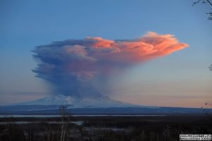
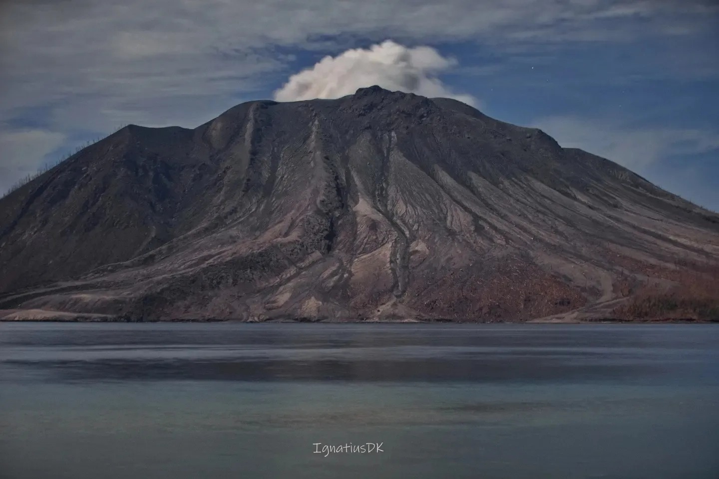
PVMBG reported that seismicity significantly increased at Ruang on 29 April and the signals indicated magma moving towards the surface. Earthquakes began to be felt at 00h15 on 30 April. At 01h15 the earthquakes intensified; residents in neighboring Tagulandang Island reportedly felt continuous shaking, heard loud roaring, and saw an ash plume rising about 2 km above the summit. Activity continued to escalate and at 01h30 the Alert Level was raised to 4 (the highest level on a scale of 1-4). The public was warned to stay 7 km away from the active crater and residents on Tagulandang within 6 km were instructed to evacuate. A webcam photo from 02h32 on 30 April showed lava being ejected above the summit; an eruptive event was recorded in seismic data at 02h35. According to the Darwin VAAC ash plumes had risen to 15.2 km (50,000 ft) a.s.l. by 0300 and to 19.2 km (63,000 ft) a.s.l. by 03h20, and by 06h20 were expanding radially; the plumes may have risen to 23 km (75,400 ft) a.s.l. or more based on other expert analysis.
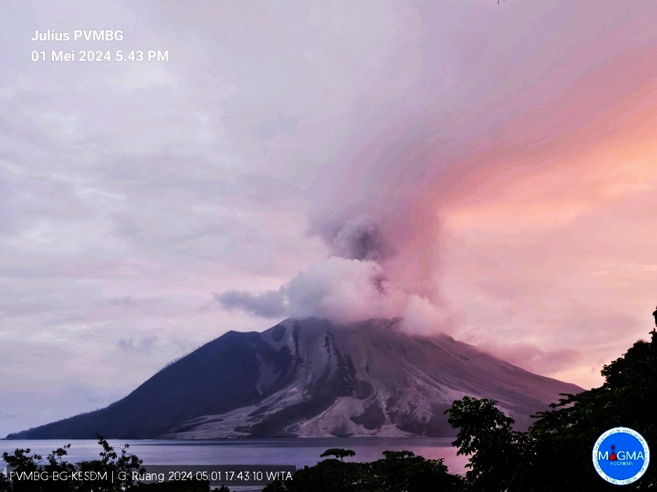
PVMBG noted that at 08h35 dense gray-to-black ash plumes rose at least 5 km and drifted E and S. A webcam photo from 08h27 showed multiple pyroclastic density currents descending the flanks. According to a characterization by BNPB the eruption ejected incandescent lava high above the summit and lightning was frequently seen in the plumes. Tephra fell over a more extensive area compared the 16-18 April eruption phase; gravel-sized tephra fell in Apengsala, about 8 km NNE from Ruang’s central vent, and outside of the exclusion zone. According to a news report residents felt shock waves from the explosions. At least three eruptive events were recorded during 12h00-18h00 that produced gray-and-black ash plumes at least as high as 1.5 km. The VAAC noted that by 15h10 the high-level plume had detached from the summit and was drifting W and SW, and ash between 13.7-19.2 km (45,000-63,000 ft) a.s.l. continued to be identified drifting WNW at least through 09h40 on 1 May. Ash plumes continued to be identified in satellite images, rising to 3 km (10,000 ft) a.s.l. and drifting N and SE at least through 12h40 on 1 May.
According to a news report the eruption and the presence of ash and ashfall caused the closure of seven airports, scheduled to reopen on 1 May: the Sam Ratulangi International Airport (98 km SW in Manado, North Sulawesi), the Gorontalo Airport (371 km SW), the Siau/Sitaro Airport (40 km N), the Bolaang Mongondow Airport (215 km SW), the Tahuna/Naha Airport (150 km N), the Pohuwato Airport (445 SW), and the Pogogul Airport (460 km WSW). On 1 May about 123 residents were evacuated to Bitung City by boat. Ashfall was notable at the Sam Ratulangi International Airport with delays affecting about 7,000 passengers.
Sources: Pusat Vulkanologi dan Mitigasi Bencana Geologi (PVMBG, also known as CVGHM), Badan Nacional Penanggulangan Bencana (BNPB), Darwin Volcanic Ash Advisory Centre (VAAC), Andrew Tupper, Natural Hazards Consulting, Antara News, GVP.
Photos : PVMBG , Dwikoen Sastro .
Tonga , Tofua :
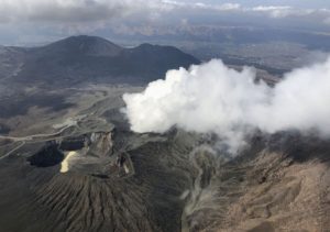
Tonga Geological Services reported that activity at Tofua increased on 26 April and was characterized as having an unusual pattern of activity. A total of 45 eruptive events were identified in data from 09h56 on 26 April to 02h46 on 28 April. An intensifying thermal anomaly was also identified in satellite images. At 22h00 on 28 April an ash plume was identified in a satellite image rising 4-6 km above the summit and drifting NW; it was no longer visible 4 hours later. A SW-drifting plume of sulfur dioxide was also identified in a few satellite images. The number of thermal anomalies over the volcano decreased during 28-30 April, and though sulfur dioxide emissions continued to be detected, the flux had decreased. Mariners were advised to stay 2 km away from the island.
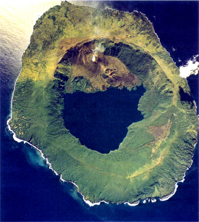
The low, forested Tofua Island in the central part of the Tonga Islands group is the emergent summit of a large stratovolcano that was seen in eruption by Captain Cook in 1774. The summit contains a 5-km-wide caldera whose walls drop steeply about 500 m. Three post-caldera cones were constructed at the northern end of a cold fresh-water caldera lake, whose surface lies only 30 m above sea level. The easternmost cone has three craters and produced young basaltic-andesite lava flows, some of which traveled into the caldera lake. The largest and northernmost of the cones, Lofia, has a steep-sided crater that is 70 m wide and 120 m deep and has been the source of historical eruptions, first reported in the 18th century. The fumarolically active crater of Lofia has a flat floor formed by a ponded lava flow.
Sources: Tonga Geological Services, Government of Tonga , GVP.
Photo : Tonga Ministry of Lands, Survey, and Natural Resources
United States , Yellowstone :
Wednesday, May 1, 2024, 9:56 AM MDT (Wednesday, May 1, 2024, 15:56 UTC)
44°25’48 » N 110°40’12 » W,
Summit Elevation 9203 ft (2805 m)
Current Volcano Alert Level: NORMAL
Current Aviation Color Code: GREEN
Recent Work and News
Steamboat Geyser erupted on April 3—the second major water eruption of the geyser so far in 2024.
May means the start of the field season in Yellowstone, and teams will be in the park setting up the seasonal semi-permanent GPS network and performing maintenance on continuous monitoring sites in the latter half of the month. During May 20-22, members of the Yellowstone Volcano Observatory consortium will also gather in Mammoth Hot Springs for the biennial coordination meeting, where they will share scientific results and discuss monitoring and research priorities. The meeting will also include a public event in Gardiner, Montana.
Seismicity
During April 2024, the University of Utah Seismograph Stations, responsible for the operation and analysis of the Yellowstone Seismic Network, located 152 earthquakes in the Yellowstone National Park region. The largest event of the month was a micro earthquake of magnitude 3.1 located about 10 miles north-northeast of West Yellowstone, Montana, on April 23 at 3:30 AM MDT.
April seismicity in Yellowstone was marked by two swarms:
1. An ongoing swarm of 86 earthquakes, located approximately 10 miles north-northeast of West Yellowstone, MT, occurred April 23–30. The largest earthquake in the sequence was the magnitude 3.1 mentioned above.
2. A swarm of 19 earthquakes, located approximately 6 miles north of West Yellowstone, MT, occurred April 28–29. The largest earthquake in the sequence was a magnitude 1.7 on April 28 at 11:58 PM MDT.
Earthquake sequences like these are common and account for roughly 50% of the total seismicity in the Yellowstone region.
Yellowstone earthquake activity is currently at background levels.
Ground Deformation
During the month of April, continuous GPS stations in Yellowstone caldera showed subsidence, which has been ongoing since 2015, interrupted in summer months by a pause or slight uplift caused by seasonal changes related to snowmelt and groundwater conditions. The caldera has subsided by about 3 cm (1.2 in) since the end of September. A slight amount of subsidence (less than 1 cm, or a fraction of an inch) has occurred at Norris Geyser Basin over the past two months.
Source : YVO
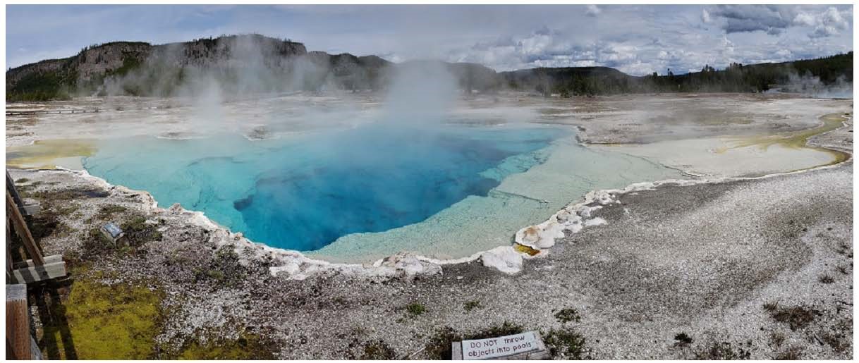
Photo : Sapphire Pool , YVO.
Japan , Sakurajima :
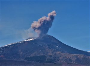
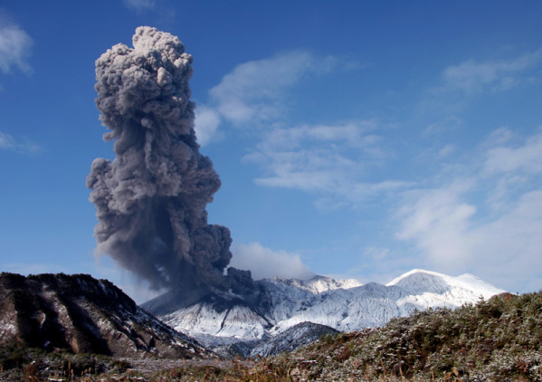
JMA reported ongoing eruptive activity at Minamidake Crater (Aira Caldera’s Sakurajima volcano) during 22-29 April with nighttime crater incandescence. Sulfur dioxide emissions averaged 1,800 tons per day on 22 April. Very small eruptive events were occasionally recorded during 22-26 April. The Alert Level remained at 3 (on a 5-level scale), and the public was warned to stay 2 km away from both craters.
The Aira caldera in the northern half of Kagoshima Bay contains the post-caldera Sakurajima volcano, one of Japan’s most active. Eruption of the voluminous Ito pyroclastic flow accompanied formation of the 17 x 23 km caldera about 22,000 years ago. The smaller Wakamiko caldera was formed during the early Holocene in the NE corner of the caldera, along with several post-caldera cones. The construction of Sakurajima began about 13,000 years ago on the southern rim and built an island that was joined to the Osumi Peninsula during the major explosive and effusive eruption of 1914. Activity at the Kitadake summit cone ended about 4,850 years ago, after which eruptions took place at Minamidake. Frequent eruptions since the 8th century have deposited ash on the city of Kagoshima, located across Kagoshima Bay only 8 km from the summit. The largest recorded eruption took place during 1471-76.
Source: Japan Meteorological Agency (JMA) , GVP
Photo : S.Nakano ( archive)
Colombia , Chiles / Cerro Negro :
Weekly Activity Bulletin: Chiles Volcanic Complex and Cerro Negro (CVCCN)
From the monitoring of the activity of the CHILES AND CERRO NEGRO VOLCANOES, the MINISTRY OF MINES AND ENERGY, through the COLOMBIAN GEOLOGICAL SERVICE (SGC), reports that:
Compared to the previous week, between April 23 and 29, 2024, an increase in seismic occurrence and a decrease in energy released were observed. The predominance of seismicity associated with the fracture of rocks continues in the region of the two volcanoes, although earthquakes associated with the movement of fluids continue to be recorded, some of them with very low frequency contents , which could imply movement of magmatic components within the volcanic complex. .
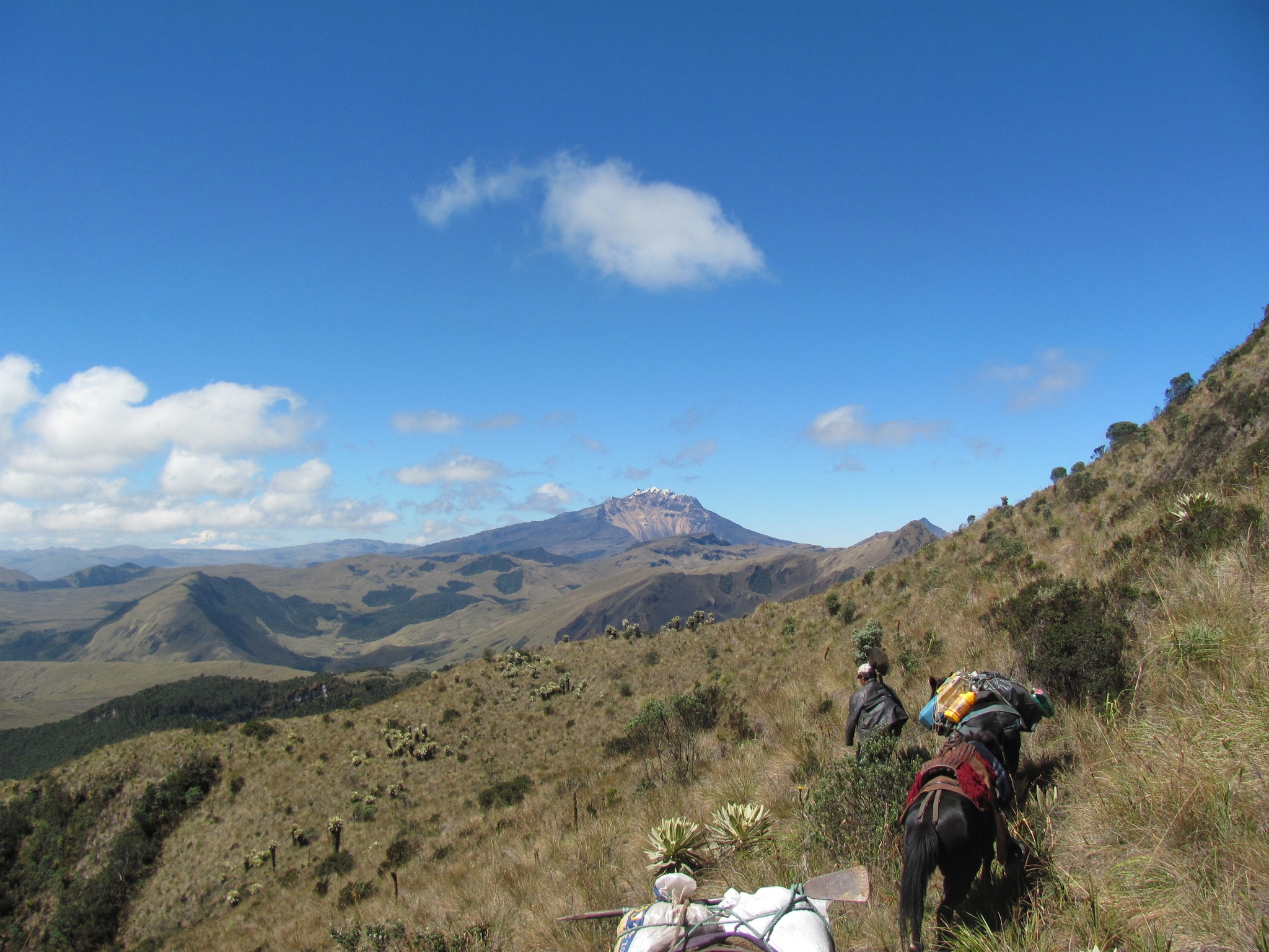
Two sources of fracture earthquakes were observed, the first with dispersed seismicity located towards the South-East of the Chiles volcano, at distances between 0.5 and 14 km, with depths between 3 and 11 km relative to its summit (4700 m above sea level) and a maximum magnitude of 1.3. The second source was located in the collapse zone north of the summit of the Chiles volcano, at distances less than 2 km, with depths between 2 and 5 km from its summit (4,700 m above sea level) and a maximum magnitude of 1.7.
Volcanic deformation processes recorded by sensors installed on the ground and by remote satellite sensors continue. The evolution of activity in the CVCCN is the result of internal processes derived from the complex interaction between the magmatic system, the hydrothermal system and the geological faults of the area. Therefore, the probability of the occurrence of energetic earthquakes that can be felt by residents in the CVCCN zone of influence persists.
Volcanic activity remains in a YELLOW ALERT state: Active volcano with changes in the behavior of the base level of monitored parameters and other manifestations.
Source et photo : SGC