February 25 , 2022.
Hawaii , Kilauea :
19°25’16 » N 155°17’13 » W,
Summit Elevation 4091 ft (1247 m)
Current Volcano Alert Level: WATCH
Current Aviation Color Code: ORANGE
Activity Summary:
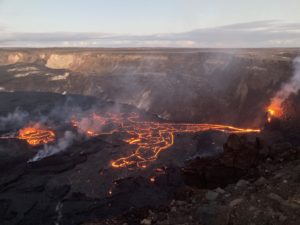
The summit eruption of Kīlauea Volcano, within Halemaʻumaʻu crater, has nearly paused corresponding with deflationary tilt and a drop in volcanic tremor. All recent lava activity has been confined to the crater, and there are no indications of activity migrating elsewhere on Kīlauea.
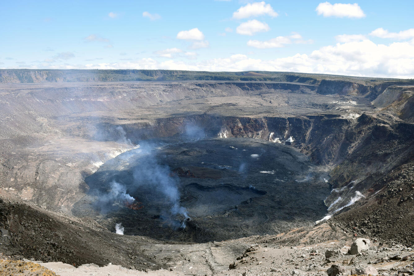
Halemaʻumaʻu Lava Lake Observations:
Eruption of lava from the western vent into the active lava lake within Halemaʻumaʻu crater has nearly paused over the past 24 hours with only slight lava output within the active lava lake level since yesterday morning. Short-lived minor flows of active lava continue to erupt from the west vent and flows to the south, west, and into the western lava lake. There were no significant ooze outs along the margins of the lava lake over the past 24 hours. This decreased effusive activity corresponds with a drop in tilt of approximately 2.6 microradians with corresponding decrease in tremor at the summit. The high point on the floor of Halema’uma’u crater has dropped approximately 10 meters (33 feet) over the last 24 hours. The active lava lake is now approximately 84 meters (276 feet) deep relative to when lava emerged on September 29, 2021. The erupted volume is 45 million cubic meters (59 million cubic yards) of lava as measured on January 25, 2021.
Summit Observations:
At approximately 5:00 pm HST on February 22, 2022, tilt started a deflationary trend with a total decrease of approximately 2.6 microradians. At 6:00 am HST yesterday tilt rates slowed and have since been steady. Seismic data shows that the volcanic tremor signal started to decrease at the same time as the tilt (approximately 5:00 pm HST on February 22, 2022) and now remains low and steady over the last 24 hours. Earthquake activity at the summit remains below background levels. A sulfur dioxide (SO2) emission rate of approximately ~630 tonnes per day (t/d) was measured on February 23.
Source : HVO.
Photo : USGS / L. DeSmither.
Mexico , Popocatepetl :
February 24, 11:00 a.m. (February 24, 5:00 p.m. GMT).
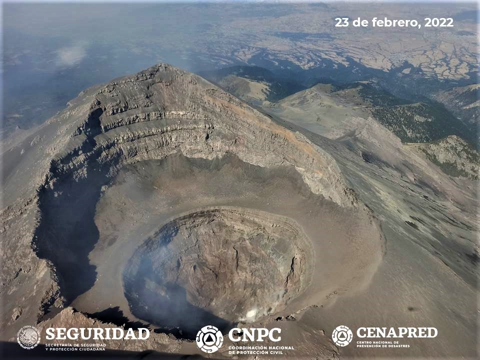
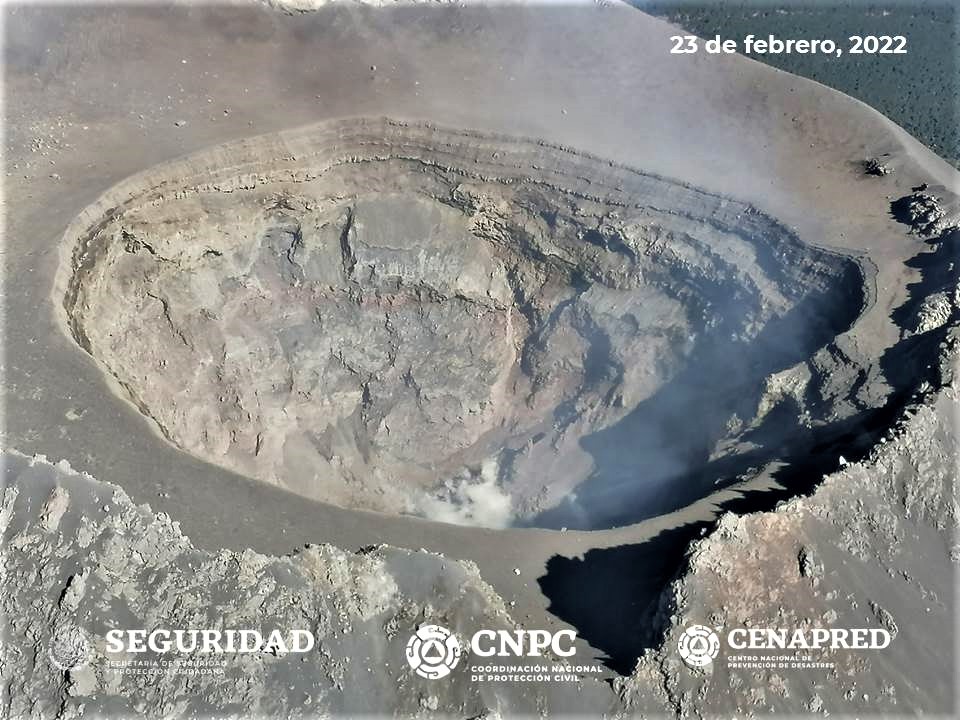
This Wednesday, February 23, with the support of the National Guard, expert personnel from the Institute of Geophysics of the National Autonomous University of Mexico (UNAM) and the National Center for Disaster Prevention (CENAPRED), an overview of the Popocatépetl volcano was made to verify its terms and conditions.
The visibility conditions were optimal, so it was possible to determine that the dimensions of the inner crater maintain an approximate diameter of 390 to 410 meters and a depth of 160 to 200 meters compared to the flyby last November. Similarly, there are apparently remnants of domes recently located at the bottom of the crater.
Based on the various parameters monitored and the information obtained during the overflight, it is considered likely that ash emissions will continue to occur. Finally, some explosions could be recorded that do not exceed in intensity those already observed. These scenarios are considered in the yellow level of phase 2 of the volcanic alert traffic light. Any changes in activity will be reported in a timely manner.
During the last 24 hours, thanks to the monitoring systems of the Popocatépetl volcano, 86 low intensity exhalations have been detected, accompanied by water vapor, gas and slight amounts of ash and 14 minutes of low amplitude tremor.
During this period, the National Center for Communications and Civil Protection Operations reported light ash fall in Atlautla, Ozumba and Tepetlixpa in the State of Mexico.
During the morning and at the time of this report, a slight emission of water vapor and volcanic gases with a west-northwest direction is observed.
CENAPRED urges NOT TO APPROACH the volcano and especially the crater, because of the danger of falling ballistic fragments and, in case of heavy rains, to stay away from the bottom of the ravines because of the danger of mudslides and of debris.
The Popocatépetl volcanic alert level is in YELLOW PHASE 2.
Source et photos : Cenapred.
Italy / Sicily , Etna :
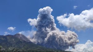
Communication on the activity of ETNA, February 24, 2022, 14:19 (13:19 UTC).
The National Institute of Geophysics and Volcanology, Osservatorio Etneo, announces that at 12:38 UTC, from surveillance cameras and what was reported by INGV personnel in the field, an ash emission was observed from the Northeast Crater, which was followed by other ash pulses of less intensity. According to the forecast model, the ashes are dispersed in the atmosphere in the South-South-East direction.
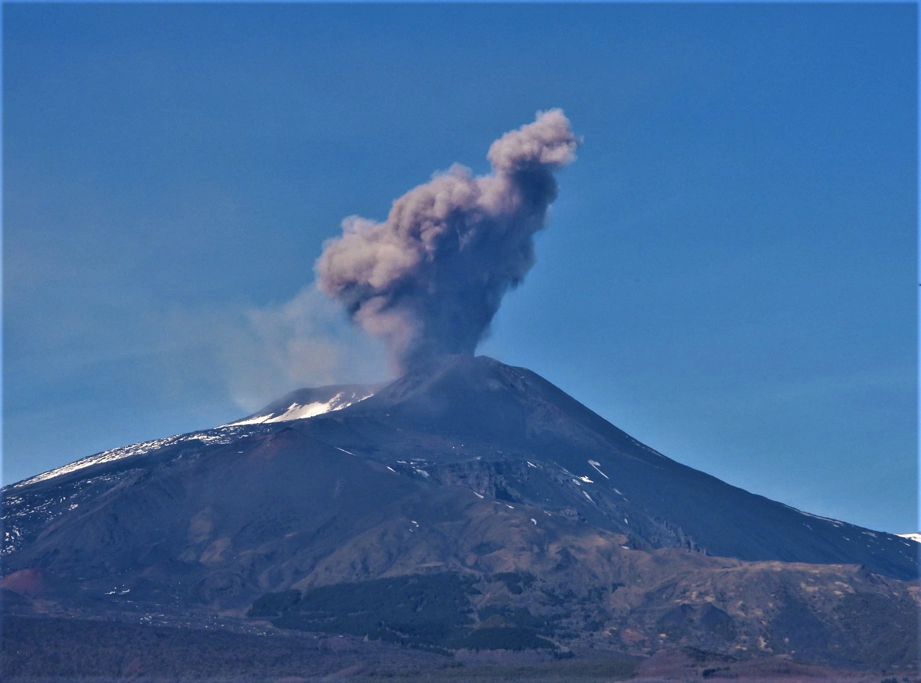
The average amplitude of the volcanic tremor is currently at a low level. The centroid of the sources of volcanic tremors is located in the area between the Bocca Nuova crater and the Southeast Crater at an altitude of about 2000-2500 meters above sea level. A slight increase in the frequency of occurrence of infrasonic events located in correspondence with the Northeast Crater is observed.
There is currently no significant variation in the deformation data from the inclinometer and GNSS networks.
Further updates will be communicated soon.
Source :INGV
Photo : Boris Behncke.
Vanuatu Archipelago , Ambae :
Volcanic activity on Ambae Island continues at major unrest levels. The Volcanic Alert Level remains at Level 2.
The activity of the volcano consists of the emission of steam and explosions of wet tephra ejected above the surface of the lake but confined inside the caldera while only very light ash is deposited on the villages located at proximity to the volcano, especially those downwind.
New observations have confirmed that the volcanic cone has accumulated inside Lake Voui and that the Ambae volcano continues to emit volcanic gases and ashes contained in Lake Vui, which is compatible with the activity of the Ambae volcano below major unrest level; the danger zone remains 2 km around volcanic vents and in the area of overflowing streams. With this current volcanic activity, it’s a helpful reminder that eruptions can occur at any level of unrest with little or no warning.
Villages near streams (hazardous flow areas) can continually expect changes in stream behavior and higher than normal flows during rainfall. Ambae should be aware of dangerous water flows when approaching these streams during heavy rains (CURRENTLY LA NINA SEASON).
Indonesia , Semeru :
VOLCANO OBSERVATORY NOTICE FOR AVIATION – VONA
Issued : February 25 , 2022
Volcano : Semeru (263300)
Current Aviation Colour Code : ORANGE
Previous Aviation Colour Code : orange
Source : Semeru Volcano Observatory
Notice Number : 2022SMR38
Volcano Location : S 08 deg 06 min 29 sec E 112 deg 55 min 12 sec
Area : East java, Indonesia
Summit Elevation : 11763 FT (3676 M)
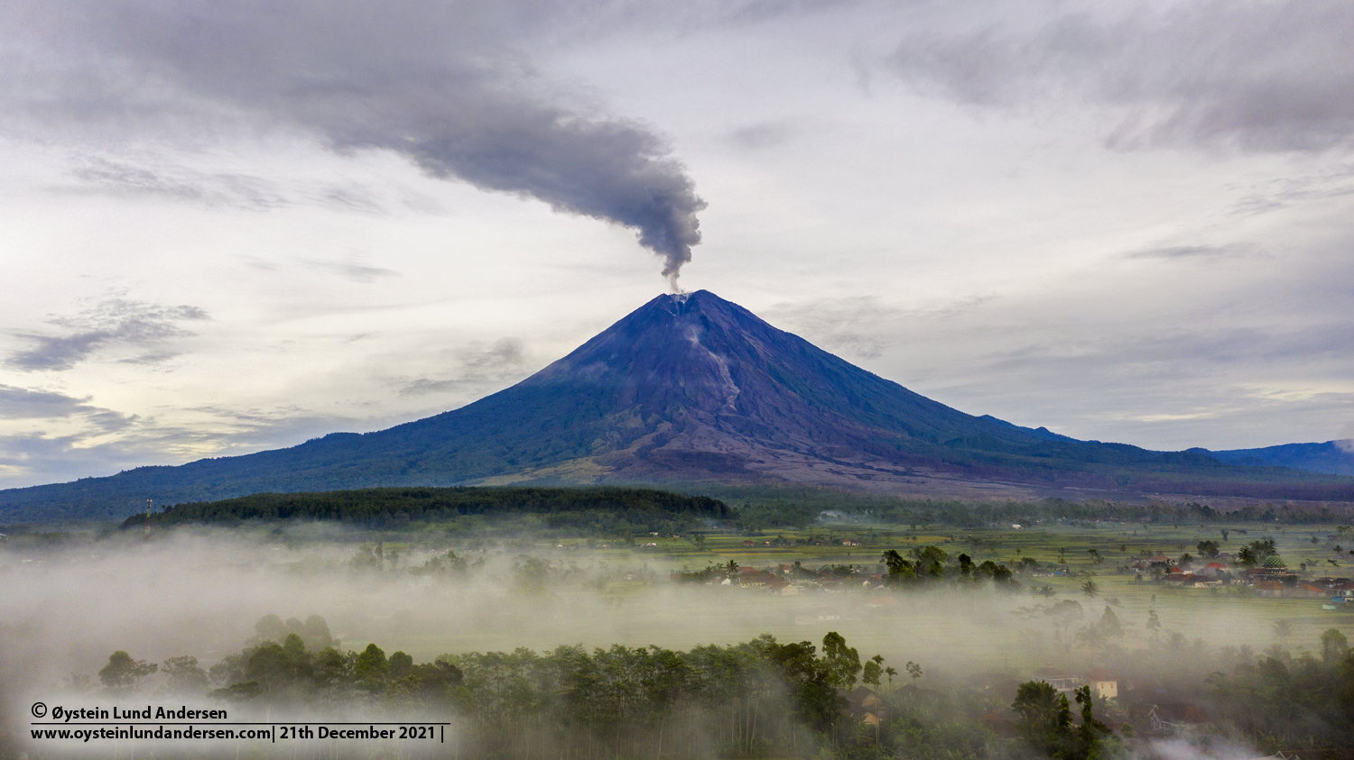
Volcanic Activity Summary :
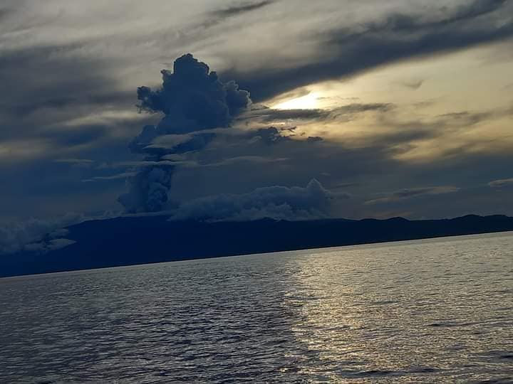
Eruption with volcanic ash cloud at 00h55 UTC (07h55 local). Eruption and ash emission is continuing.
Volcanic Cloud Height :
Best estimate of ash-cloud top is around 14003 FT (4376 M) above sea level, may be higher than what can be observed clearly. Source of height data: ground observer.
Other Volcanic Cloud Information :
Ash-cloud moving to north.
Source : Magma Indonésie .
Photo : Oystein Lund Andersen.