April 16 , 2024.
Indonesia , Ruang :
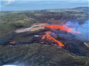
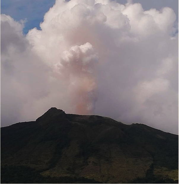
Press release on the activity of Mount Ruang, April 15, 2024.
(G.) Ruang Volcano is a stratovolcano type volcano and rises 725 m above sea level from the coastline while forming an island distinct from the other islands. Geographically, G. Ruang is located at the coordinate position 2o19′ 18.30″ N latitude and 125o 24′ 30.42 E longitude. The Ruang volcano has been observed visually and instrumentally from the volcano observation post (PGA) located in Tagulandang District, North Sulawesi.
The latest developments on G. Ruang’s activities until April 15, 2024 are as follows:
Visual observations at this time do not observe crater smoke.
Volcanic seismicity at Mount Ruang tends to be quiet, dominated by tectonic earthquakes, estimated to be the influence of North Sulawesi subduction and double subduction in the Molucca Sea.
There has been an increase in seismicity, especially deep volcanic (VT) earthquakes following the tectonic earthquake of April 9, 2024 and April 14, 2024. According to the BMKG, the tectonic earthquake of April 9 had a magnitude of 6.4, a depth of 27 km and was located 94 km northwest of the island of Doi, north of the Moluccas. Meanwhile, the April 14 tectonic earthquake had a magnitude of 5.1, a depth of 10 km and was located 122 km southwest of the island of Doi, in the North Moluccas. Both earthquakes were felt on the I MMI scale.
The volcanic activity of G. Ruang until April 15, 2024 was still dominated by deep tectonic earthquakes, however, after the tectonic earthquake felt in the G. Ruang region, an increase in the number of deep volcanic earthquakes was recorded, namely: April 10 (occurred 4 times), April 11 (5 times), April 12 (6 times), April 13 (17 times), April 14 (23 times) and until 6:00 p.m. WITA on April 15 (42 times). Deep volcanic earthquakes are generally related to the process of migration of magma from deep to shallow depths.
Based on visual and instrumental monitoring until April 15, 2024, the Geological Agency declared that the activity level of G. Ruang is still at level I (NORMAL).
At Level I (NORMAL) activity level, people around Mount Ruang and visitors/tourists are recommended to remain vigilant: (a) To avoid approaching the active crater of Mount Ruang. (b) Visitors are not permitted to stay overnight in active areas of the crater. (c) Do not approach the gas vents around the crater to avoid the potential danger of toxic gas.
Activity levels will be examined if there are significant visual and seismic changes.
Increased G. Ruang activity levels from Level I (Normal) to Level II (Waspada)
The evaluation report on the activities of G. Ruang, North Sulawesi is hereby submitted as follows:
Visual observation
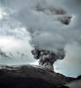
The volcano is clearly visible until it is covered in fog. Smoke from the crater began to be observed on the morning of April 16 at a height of 200 to 500 m, white in color, thick.
Instrumental observation
Between April 1 and 15, 2024, the earthquakes recorded on Mount Ruang were 210 deep volcanic earthquakes (VTAs), 3 local tectonic earthquakes, and 163 deep tectonic earthquakes. Felt earthquakes were recorded twice on the MMI I scale. The number of earthquakes, especially deep volcanic earthquakes, which occurred between April 1 and 15, increased significantly compared to March 2024.
The volcanic activity of G. Ruang until April 15, 2024 was still dominated by deep tectonic earthquakes, however, after the tectonic earthquake felt in the G. Ruang region, an increase in the number of deep volcanic earthquakes was recorded, namely: April 10, 2024 (occurred 4 times), April 11, 2024 (5 times), April 12, 2024 (6 times), April 13, 2024 (17 times), April 14, 2024 (23 times) and April 15, 2024 (146 times).
Assessment
In general, the volcanic seismicity of Mount Ruang tends to be low, dominated by tectonic earthquakes, thought to be the influence of North Sulawesi subduction and double subduction in the Molucca Sea. However, the volcanic activity of Mount Ruang until the period of April 1-15, 2024, in addition to being dominated by deep tectonics, experienced an escalation in the emergence of deep volcanic earthquakes (VTA) after the tectonic earthquake of April 9 and 14, 2024. The emergence of deep volcanic earthquakes (VTA) is generally linked to the migration of magma from the depths to the surface.
Recommendation
Based on the results of visual and instrumental monitoring, it shows that there has been an increase in volcanic activity on Mount Ruang, so the activity level of Mount Ruang has been increased from level I ( normal) at level II (WASPADA). from April 16, 2024 at 10:00 WITA.
Source : PVMBG
Photos : Marwan Mohamad , PVMBG.
Indonesia , Merapi :
MOUNT MERAPI ACTIVITY REPORT, from April 5 to April 11, 2024. Published on April 12, 2024
OBSERVATION RESULT
Visual
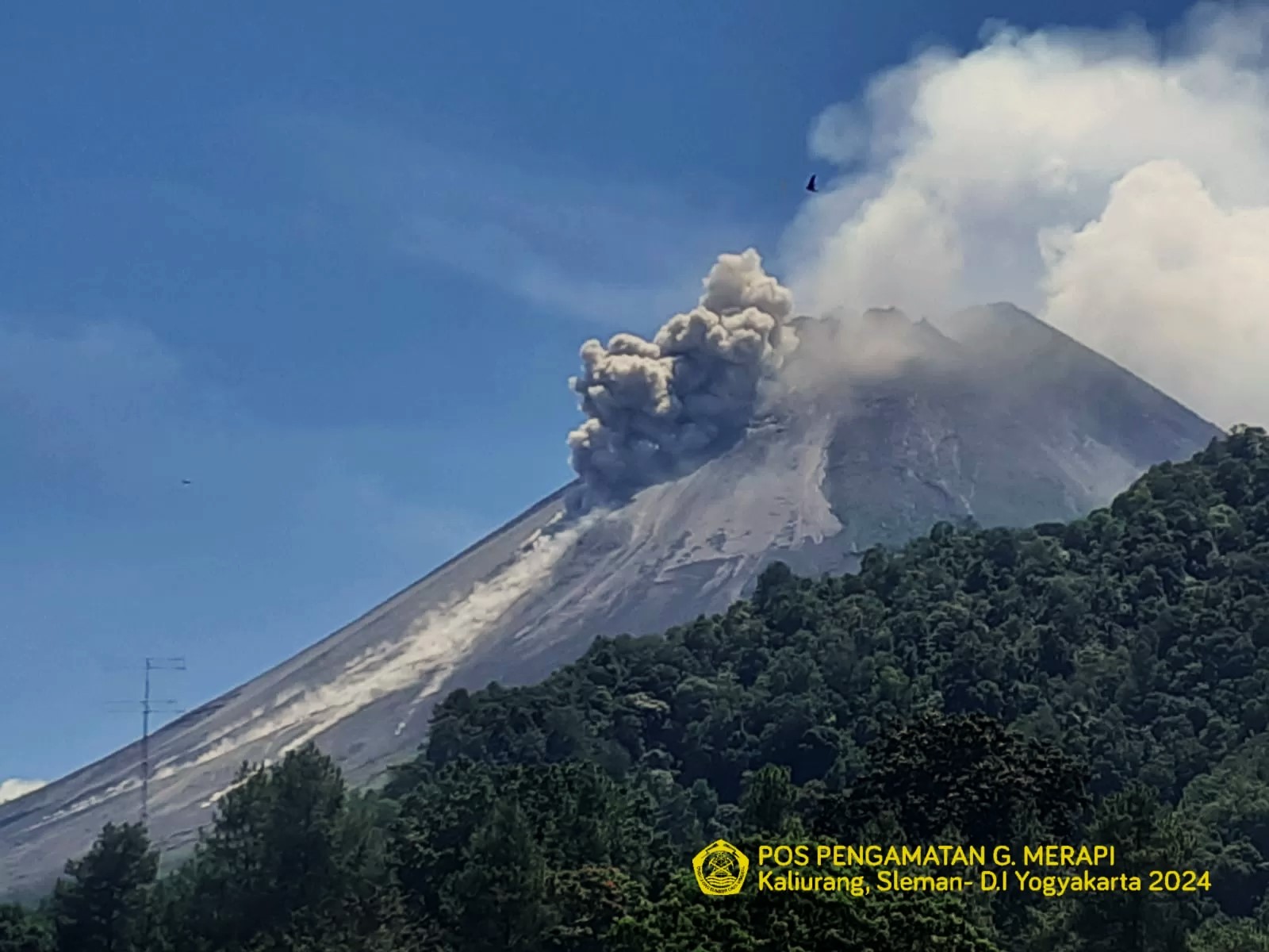
The weather around Mount Merapi is generally clear in the morning and night, while it is foggy from noon to evening. White smoke, thin to thick, low to moderate pressure and 170 m high was observed from the Badaban Mount Merapi observation post on April 10, 2024 at 06:24 WIB. This week, there was a warm cloud avalanche in the southwest (upstream of the Bebeng River) with a sliding distance of 1,100 m. Lava avalanches were observed 103 times towards the southwest up to a maximum of 1,800 m.
The morphology of the southwest dome was observed to change due to the activity of hot cloud avalanches and lava avalanches. Based on the analysis of aerial photos dated March 30, 2024, the volume of the southwest dome was measured at 2,054,600 m3 and that of the central dome at 2,358,200 m3.
Seismicity
This week, the seismicity of Mount Merapi recorded:
1 warm cloud avalanche (APG) earthquake,
75 shallow volcanic earthquakes (VTB),
434 multi-phase (MP) earthquakes,
14 low frequency (LF) earthquakes.
425 avalanche earthquake (RF),
17 tectonic earthquakes (TT).
The intensity of earthquakes this week is higher than last week.
Deformation
The deformation of Mount Merapi monitored by EDM this week showed a shortening rate of 0.9 cm/day.
Rain and lahars
This week there was rain at Mount Merapi lookout post with a rain intensity of 62 mm/hour for 220 minutes at Kaliurang lookout post on April 11, 2024. No additional flow or lahar was reported in the rivers that have their source on Mount Merapi.
Conclusion
Based on the results of visual and instrumental observations, it was concluded that: The volcanic activity of Mount Merapi is still quite high in the form of effusive eruptive activity. The activity status is set to the “SIAGA” level.
Source : BPPTKG
Photos : BPPTKG
Costa Rica , Poas / Rincon de la Vieja :
Poas Volcano:
Latitude: 10.2
Longitude: -84,233
Altitude: 2,687 meters.
Activity observed:
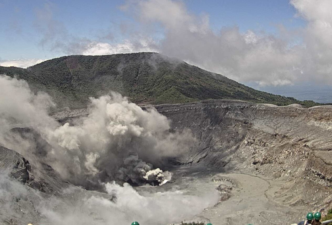
During the last 24 hours, the OVSICORI-UNA seismographs of Poás recorded signals of intermittent low-intensity volcanic tremors with frequencies between 1.5 and 4 Hz. No eruptions were detected in the seismographs or sensors to infrasound, but they observed one. slight emission of ash in the fumaroles. The ExpoGAS gas detector at El Mirador para Visitantes recorded less than 2 parts per million of SO2 in the ambient air. The MultiGAS gas detection system located on the western rim of the active crater records the ratios and maximum concentrations of stable gases within normal limits: CO2/SO2=1, H2S/SO2=0.6, SO2=9 parts per million .
Yesterday, April 13, 2024, residents of the following localities reported a smell of sulfur in the ambient air: Grecia and Trojas de Sarchí. The Volcanic Gas and Aerosol Monitoring Station of the OVSICORI-EDECA-UNA/EMVA Coronado School recorded low and normal concentrations of SO2 gas in the ambient air of Coronado today, April 14, just 1 part per billion (ppb) after the record values of March 23 (28 parts per billion ppb) and April 3 (36 ppb) associated with gas and ash emissions from Poás.
Environmental conditions:
The summit of Poás remains clear with light rain (2.2 mm accumulated over the last 24 hours, IMN) and moderate winds directed towards the South-West at a maximum speed of 48 km/h (IMN).
Activity Level: Warning (2)
Rincón de la Vieja Volcano
Latitude: 10.83
Longitude:-85.324
Altitude: 1,916 meters.
Activity observed:
The OVSICORI-UNA seismographs are currently detecting a relatively low level of seismic activity compared to previous months. Over the past 24 hours, 3 low energy releases of gases, vapors and aerosols have been detected across the main crater. The tremor continues to be recorded sporadically and with low intensity with frequencies between 1 and 4 Hz. No eruptions have been recorded.
Environmental conditions:
High cloudy conditions remain at Rincón Summit, with winds heading southwest at 69 km/h (Windy.com).
Activity Level: Caution (3)
Source : Ovsicori
Photos : Ovsicori , Raul Mora / RSN / UCR.
Ecuador / Galapagos , Fernandina :
DAILY REPORT ON THE ACTIVITY OF THE FERNANDINA VOLCANO. Quito, Monday April 15, 2024.
From April 14, 2024 11:00:00 to April 15, 2024 11:00:00
Activity level:
Surface: Moderate; Surface trend: No changes
Internal: Moderate; Internal trend: No changes
Gas:
The Mounts satellite system detected 247.4 tons of sulfur dioxide (SO2) recorded at 1:40 p.m. TL on 04/14/2024.
Other monitoring parameters:
The FIRMS satellite system recorded 164 thermal anomalies over the past 12 hours. The MIROVA-VIIRS satellite system recorded 5 high thermal anomalies, and the MIROVAMODIS satellite system recorded 2 high thermal anomalies in the last 24 hours.
Observation:
Thanks to the GOES-16 satellite system, slight thermal anomalies linked to the activity of the volcano were recorded.
Source : IGEPN
Photo : Parque Nacional Galapagos
Alaska , Shishaldin :
Unrest at Shishaldin Volcano continues, with occasional small earthquakes and mild tremor recorded over the past day. Weak steaming from the summit was observed in partly cloudy satellite and webcam views.
The last significant ash-producing eruption occurred in November 2023.
Local seismic and infrasound sensors, web cameras, and a geodetic network are used to monitor Shishaldin Volcano. In addition to the local monitoring network, AVO uses nearby geophysical networks, regional infrasound and lighting data, and satellite images to detect eruptions.
Source : AVO
Photo : Barnes, Chris