
March 21 , 2021.
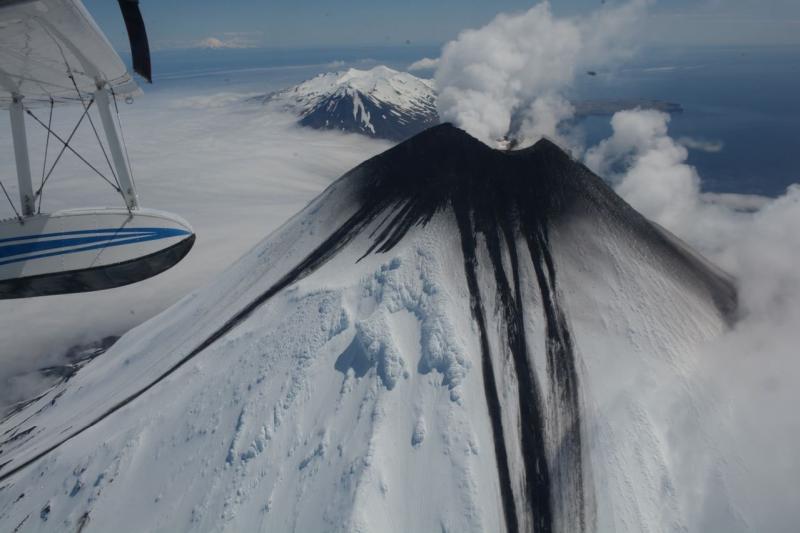
Iceland , Fagradalsfjall :
A minor eruption underway
Updated 20.03 11:10
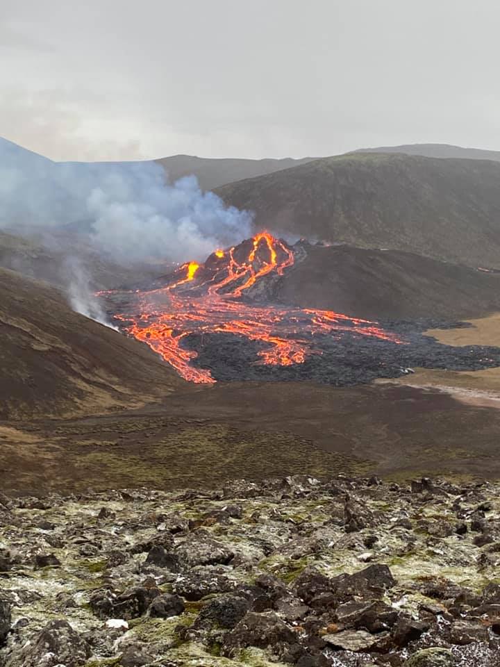
The eruption is considered small at this stage and the volcanic activity has somewhat decreased since yesterday evening. The eruptive fissure is appr. 500 – 700 m long. The lava area is less than 1 km2 covering an area that is appr. 500 m wide. Lava fountains are small and lava flows are currently a very local hazard. The seismic activity is minor and spread around the Fagradalsfjall area. There is no indication of production of ash and tephra and currently gas pollution is not expected to cause much discomfort for people except close up to the source of the eruption. The gas emittions will be monitored closely.
The aviation color code for Keflavik international airport has been lowered to orange as there is no indication of production of ash and tephra and there is no imminent hazard for the aviation.
Reykjanesbraut – the main road from the capital region to Reykjanesbær and the international airport at Keflavík is open. However, Suðurstrandarvegur – the road along the south coastline of Reykjanes peninsula is closed between the two coastal towns Grindavík and Þorlákshöfn. Other roads and unpaved tracks in the close vicinity of the eruption site are also closed.
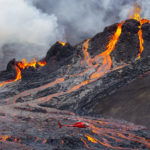
Updated 20.03 13:45
What we know so far
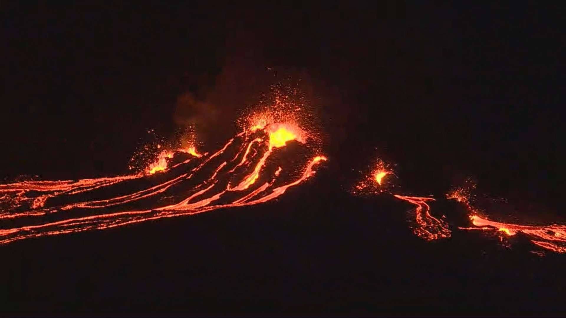
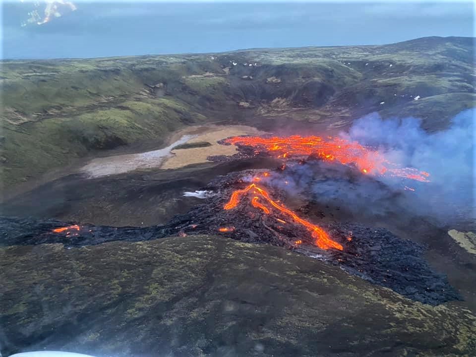
At around 20:45 UTC 19 March 2021, a volcanic eruption began at Geldingadalur, close to Fagradalsfjall on the Reykjanes Peninsula. The eruption was first seen on a web camera positioned close the mountain. It was also confirmed on thermal satellite imagery.
The eruption site is in a valley, about 4.7 km inland from the southern coast of the peninsula. The coastal town of Grindavík is the closed populated region to the eruption site, located approximately 10 km to the southwest.
The eruption is considered small at this stage and the eruptive fissure is appr. 500 – 700 m long. The area of the lava is covering an area that is appr. 500 m wide and considered less than 1 km2. Lava fountains are small and lava flows are currently a very local hazard. The seismic activity is minor and spread around the Fagradalsfjall area.
The aviation colour code for Keflavik international airport has been lowered to orange as there is no indication of production of ash and tephra and no imminent hazard for the aviation.
Volcanic gas (SO2) has been detected at the source of the eruption. A model for gas dispersion can be seen at the IMO web site. Currently, gas pollution is not expected to cause much discomfort for people except close up to the source of the eruption. The gas emissions will be monitored closely.
The area of the eruption is considered very dangerous – the eruption site can change without notice and put people at risk unexpectedly.
The eruption is still ongoing. Lava fountain activity is low and mapping of the lava flow is in progress. No volcanic ash has been detected but high level of volcanic gases has been measured close to the eruption site.
Source : Vedur Is .
Photo : Gisli Rafn Olafsson , Landhelgisgæsla Íslands/Icelandic Coast Guard .
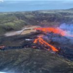
Hawaii , Kilauea :
19°25’16 » N 155°17’13 » W,
Summit Elevation 4091 ft (1247 m)
Current Volcano Alert Level: WATCH
Current Aviation Color Code: ORANGE
Activity Summary:
Kīlauea Volcano is erupting. Lava activity is confined to Halemaʻumaʻu, with lava erupting from a vent on the northwest side of the crater . Laser rangefinder measurements this morning, indicate that the total depth of the lava lake is 222 m (728 ft). SO2 emission rates remain elevated; a measurement on March 18 was 700 t/day.
Summit Observations:
The most recent sulfur dioxide emission rate, measured on March 18, was 700 t/day; this is elevated compared to rates in the months before the eruption started on December 20 (less than 100 t/day), but lower than rates from the pre-2018 lava lake (around 5,000 t/day). Summit tiltmeters recorded minor inflationary tilt over the past day as part of a deflation-inflation (DI) event. Seismicity remains stable, with elevated tremor compared to observations before the eruption.
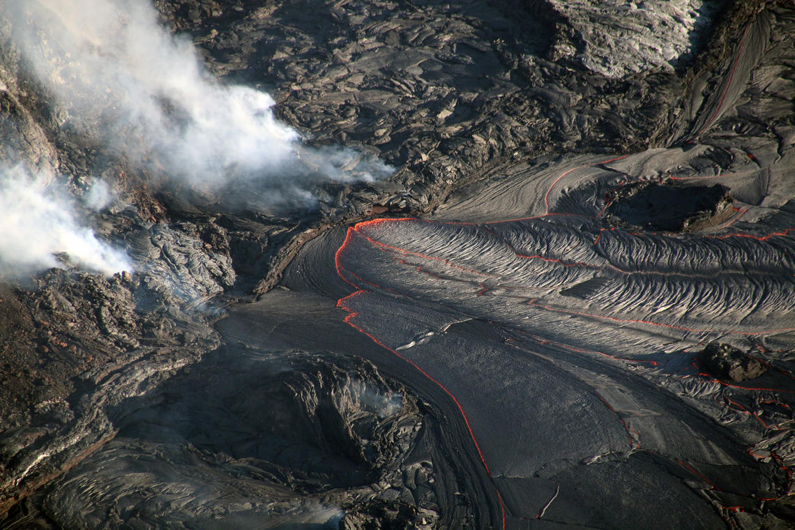
On Thursday, March 18, lava continued to erupt from the west vent in Halema‘uma‘u crater at Kīlauea Volcano’s summit. Two lava inlets near the base of the west vent (center) supply lava into the lava lake. This photo was taken around 7:15 a.m. HST from the south rim of Halema‘uma‘u crater.
Halemaʻumaʻu lava lake Observations:
The main section of the west vent is consistently effusing lava through two crusted-over channels and submerged inlets to the lake.
Lava circulation and intermittent foundering of thin crust continue in the active western portion of the lava lake.
Stagnant and solidified lava crust covers the eastern portion of the lava lake and is slowly growing westward around the main island, apparently preventing any lateral movement of this island or any of the smaller enclosed islands. Rangefinder measurements and visual observations on March 15 indicate that the eastern portion of the lake is approximately 5 m (16 ft) lower than the active western portion.
Source : HVO.
Photo : USGS / K. Lynn.
Alaska , Cleveland :
AVO/USGS Volcanic Activity Notice
Current Volcano Alert Level: ADVISORY
Previous Volcano Alert Level: UNASSIGNED
Current Aviation Color Code: YELLOW
Previous Aviation Color Code: UNASSIGNED
Issued: Saturday, March 20, 2021, 1:44 PM AKDT
Source: Alaska Volcano Observatory
Notice Number: 2021/A75
Location: N 52 deg 49 min W 169 deg 56 min
Elevation: 5676 ft (1730 m)
Area: Aleutians
Volcanic Activity Summary:
Satellite detections of increased volcanic gas emissions and elevated surface temperatures have been observed at Cleveland Volcano beginning on March 17, 2020. In addition, a local earthquake occurred on March 10 and it was large enough to be measured on seismometers 100 km away on Umnak Island. These data indicate a potential for increased eruptive activity at Cleveland. As a result, AVO is raising the Aviation Color Code to YELLOW and the Volcano Alert Level to ADVISORY.
Cleveland last erupted on June 2, 2020 AKDT (June 1, 2020 UTC) producing a small ash cloud to 22,000 ft. Explosions from Cleveland typically produce relatively small volcanic ash clouds that dissipate within hours; however, more significant ash emissions are possible.
Recent Observations:
[Volcanic cloud height] none
[Other volcanic cloud information] n/a
Remarks:
Cleveland Volcano is monitored with a limited real-time seismic network. This smaller network inhibits AVO’s ability to detect precursory unrest that may lead to an explosive eruption. Rapid detection of an ash-producing eruption may be possible using a combination of seismic, infrasound, lightning, and satellite data.
Source : AVO
Photo : Mees, Burke.
Ecuador , Reventador :
DAILY REPORT OF THE STATE OF THE REVENTADOR VOLCANO, Saturday March 20, 2021.
Information Geophysical Institute – EPN.
Surface activity level: High, Surface trend: No change.
Internal activity level: High, Internal trend: No change.
Seismicity: From March 19, 2021, 11:00 a.m. to March 2, 2021, 11:00 a.m.
Explosions (EXP): 79 events
Long period type events (LP): 65
Tremor (TRE): 8
Harmonic Tremor (TRARM): 1
Rains / lahars: No rains were detected in the area.
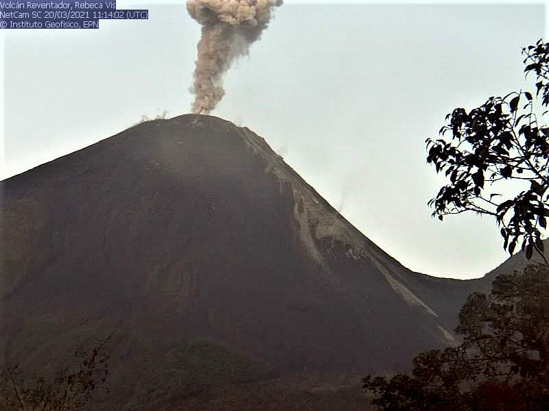
Ash Emission / Column: Over the past 24 hours, several ash emissions have been observed northbound, with heights approaching 800 to 1000 meters above crater level. The Washington VAAC reported 4 alerts of emissions observed by the satellites, their direction of dispersion varied between the Northeast and the East. The heights of these emissions ranged from 1,000 to 1,400 meters above the crater level.
Other monitoring parameters: FIRMS has recorded 4 thermal alerts on the Reventador in the last 24 hours.
Observations: During the last 24 hours, the volcano has sometimes cleared, making it possible to observe the emissions already described. At night, an incandescence was observed in the crater as well as the rolling of the blocks on the northeast flank of the volcano.
Niveau d’alerte: Orange.
Source et photos : IGEPN.
Mexico , Popocatepetl :
March 20, 11:15 a.m. (March 20, 5:15 p.m. GMT)
During the last 24 hours, according to the monitoring systems of the Popocatepetl volcano, 64 exhalations and 85 minutes of tremor have been identified, accompanied by emissions of water vapor, volcanic gases and sometimes small amounts of ash. Also early in the morning, an incandescence was observed over the volcano.
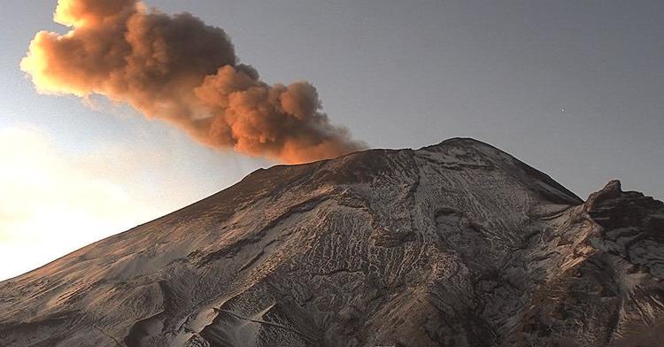
During this morning, a constant emission of volcanic gases and sometimes a slight quantity of ash was observed, which disperses towards the South-East.
CENAPRED urges NOT TO APPROACH the volcano and especially the crater, because of the danger posed by the fall of ballistic fragments and, in the event of heavy rains, to stay away from the bottom of the ravines because of the danger of lava flows. mud.
The Popocatépetl volcanic alert signal light is in PHASE 2 YELLOW.
Source et photo : Cenapred .


No comment yet, add your voice below!