March 28 , 2024.
Aleutian Islands , Atka :
AVO/USGS Volcanic Activity Notice
Current Volcano Alert Level: ADVISORY
Previous Volcano Alert Level: NORMAL
Current Aviation Color Code: YELLOW
Previous Aviation Color Code: GREEN
Issued: Wednesday, March 27, 2024, 9:06 PM AKDT
Source: Alaska Volcano Observatory
Notice Number: 2024/A287
Location: N 52 deg 19 min W 174 deg 8 min
Elevation: 5030 ft (1533 m)
Area: Aleutians
Volcanic Activity Summary:
A small, short-lived explosion was detected at the Atka volcanic complex this evening at 19:36 AKDT March 27 (03:36 UTC March 28), and AVO is increasing the Aviation Color Code to YELLOW and the Volcano Alert Level to ADVISORY. The event was detected in local infrasound and seismic data and was followed by a few minutes of elevated seismic tremor. Processing of the local infrasound data indicates the explosion originated from the summit crater of Korovin, one of several volcanoes within the Atka volcanic complex. No ash emissions have been observed in satellite images.
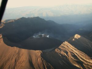
East flank of Korovin volcano as viewed off the NE shore of Atka Island from the M/V Steadfast. From left to right, volcanic features are Konia and Korovin.
Remarks:
The Atka volcanic complex forms the northern part of Atka Island, located about 16 km north of the community of Atka and 1,761 km southwest of Anchorage. The Atka volcanic complex includes a possible older caldera and several younger vents, including Korovin Volcano, Mount Kliuchef, and Sarichef Volcano. Korovin Volcano, a 1553-m-high (5030 ft) stratovolcano, has been the site of most historical volcanic activity, and has a small, roiling crater lake that occasionally produces energetic steam emissions. Korovin has erupted several times in the past 200 years, including 1973, 1987, and 1998, and has likely had small ash emissions as recently as 2005. Typical recent Korovin eruptions produce minor amounts of ash and occasional but small lava flows. Reports of the height of the ash plume produced by the 1998 eruption ranged as high as 10,600 m (35,000 feet) above sea level. Mount Kliuchef is composed of a series of five vents aligned northeast–southwest. The two main summit vents of Kliuchef appear relatively young and the easternmost was probably the source of an 1812 eruption that is sometimes attributed to Sarichef.
Source : AVO
Photo : Schaefer, Janet ( courtesy of the AVO/ADGGS. )
Iceland : Reykjanes Peninsula :
Activity of the volcanic eruption remains steady . Continued hazard due to volcanic gas
Updated 27. March at 14:00 UTC
High levels of SO2 (Sulfur Dioxide) were measured over the weekend. Gas dispersion forecast can be followed here .
This concentration of SO2 is considered very unhealthy. It is important to pay close attention to developments in air quality.
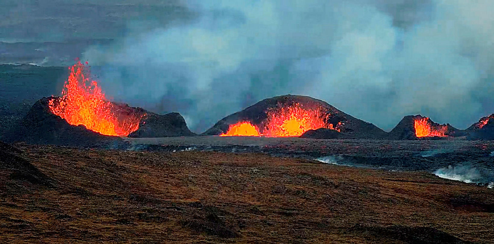
Eruption tremor has remained consistent since then, as has the activity in the three craters. Lava continues to flow southward from the craters mostly atop the lava field formed during the first days of the eruption. The following image shows the extension of the lava field as extrapolated from satellite images (ICEYE). The latest acquisition was on 26 March and it shows the widening of lava field towards the west, south of Hagafell, as well as further lava advancement towards the east and the south of the active vents.
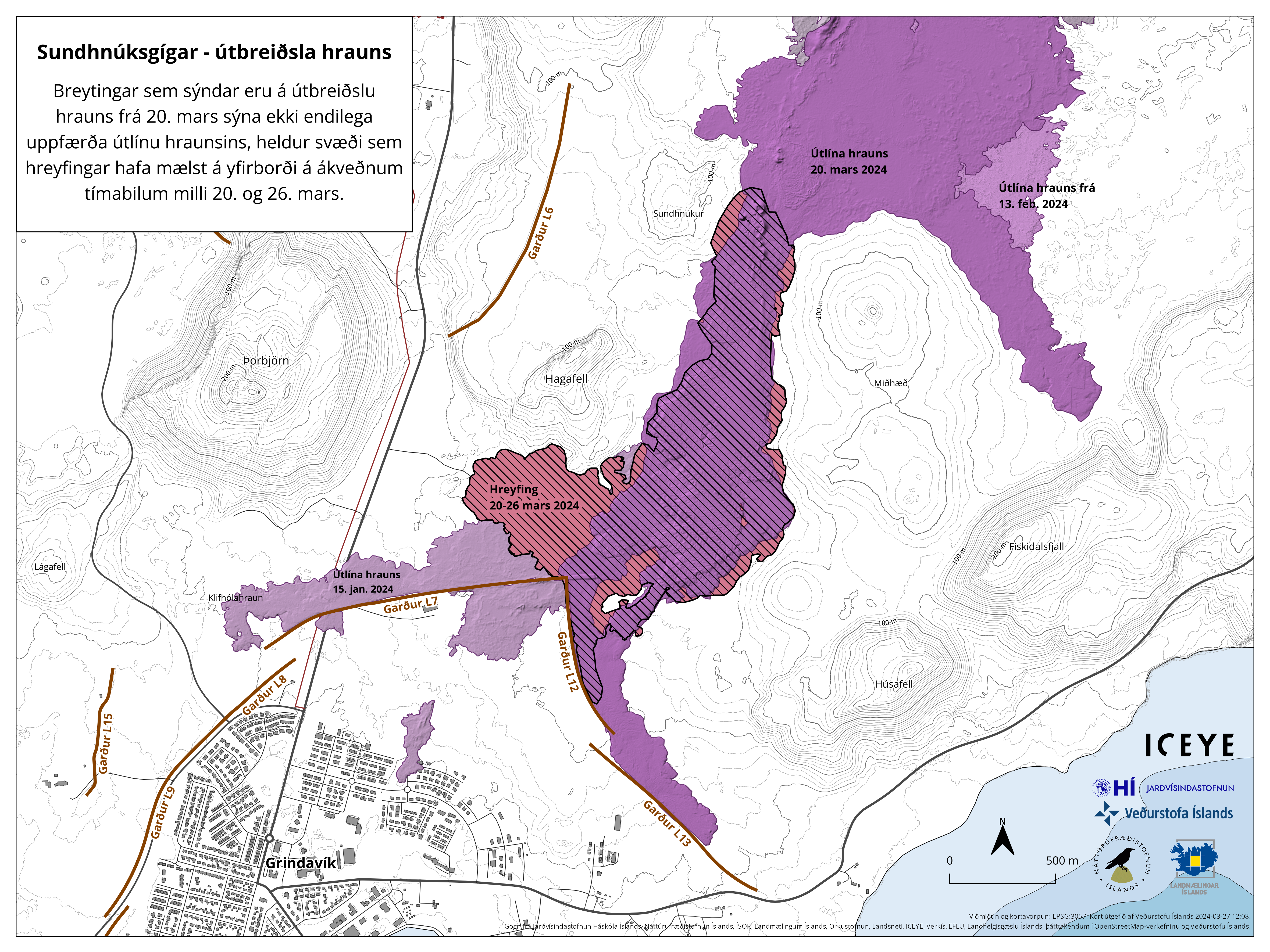
Striped areas indicate regions where changes occurred in the lava field between March 20 and 26. The red-striped part of the area signifies area where lava had not flowed previously in this eruption. Light purple areas denote areas where lava flowed from eruptions in February and January.
Uplift continues in Svartsengi but at a slower rate than prior to previous eruptions or dike intrusions in recent months. This suggests that magma is still accumulating beneath Svartsengi despite ongoing eruption. Little to no seismic activity has been detected in the area.
High levels of SO2 measured past few days
Since friday (22 mars) two additional stations to monitor the concentrations of SO2 at the ground have been installed. VÍ, in collaboration with Almannavarnir, located them at Blue Lagoon and in the harbour area in Grindavík. Both stations are streaming data to the UST website, loftgæði.is.
Early yesterday morning, at around 03:00, the station in BL revealed levels of SO2 up to 7000 microgram/m3, and this morning at around 04:00 the station in Grindavík (Nesvegur) measured concentrations up to 9000 micrograms/m3. Such concentrations are considered unhealthy and people are recommended to follow the instructions provided by UST and Embætti landlæknis (link). On the 26th March, the station in Hafnir also showed high concentrations of SO2 up to about 2000 microgram/m3 around midday. The amount of SO2 released by the eruption and the meteorology in the area are still creating the conditions for severe gas pollution in the peninsula.
Source : IMO.
Photos : IMO , mbl.is’s webcams.
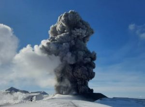
Indonesia , Dukono :
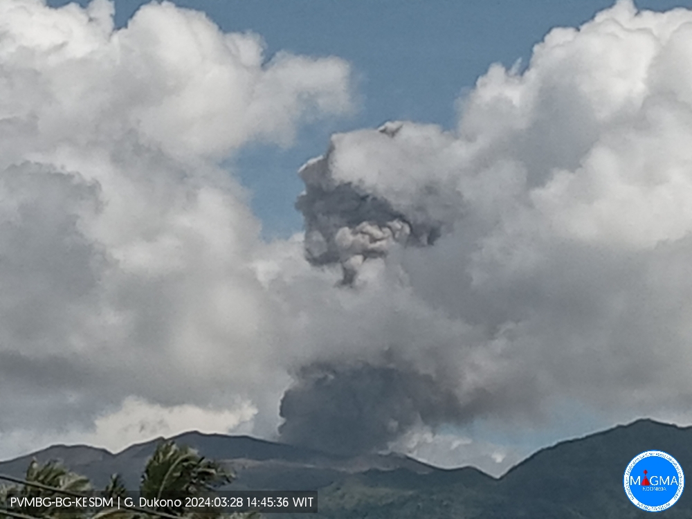
An eruption of Mount Dukono occurred on Thursday, March 28, 2024 at 2:44 p.m. WIT with the height of the ash column observed at ±1,200 m above the summit (±2,287 m above the level of the sea). The ash column was observed to be white to gray in color with thick intensity, oriented towards the North-West. At the time of writing, the eruption was still ongoing.
Seismicity:
26 eruption/explosion earthquakes with an amplitude of 4 to 25 mm and an earthquake duration of 29.67 to 54.89 seconds.
1 local tectonic earthquake with an amplitude of 5 mm, and duration of the earthquake 43.23 seconds.
4 distant tectonic earthquakes with an amplitude of 4-20 mm, earthquake duration 69.92-97.36 seconds.
1 Continuous tremor with an amplitude of 0.5 to 2 mm, dominant value of 1 mm.
RECOMMENDATION
(1) People around Mount Dukono and visitors/tourists are advised not to do activities, climb or approach Malupang Warirang Crater within a 3 km radius.
(2) Since eruptions with volcanic ash occur periodically and the distribution of ash follows the wind direction and speed, so the ash landing area is not fixed, it is recommended for People around Mount Dukono always wear masks/nose and mouth coverings to use when needed to avoid the threat of volcanic ash on the respiratory system.
Pusat Vulkanologi dan Mitigasi Bencana Geologi (PVMBG) reported that Dukono continued to erupt during 20-26 March. Gray-and-white emissions rose as high as 450 m above the summit. The Alert Level remained at Level 2 (on a scale of 1–4), and the public was warned to remain outside of the 3-km exclusion zone.
Sources : Magma Indonésie , GVP
Photo : PVMBG
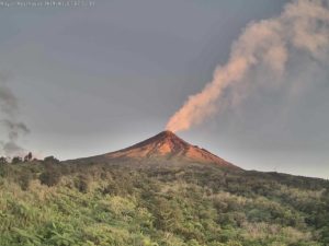
Japan , Sakurajima :
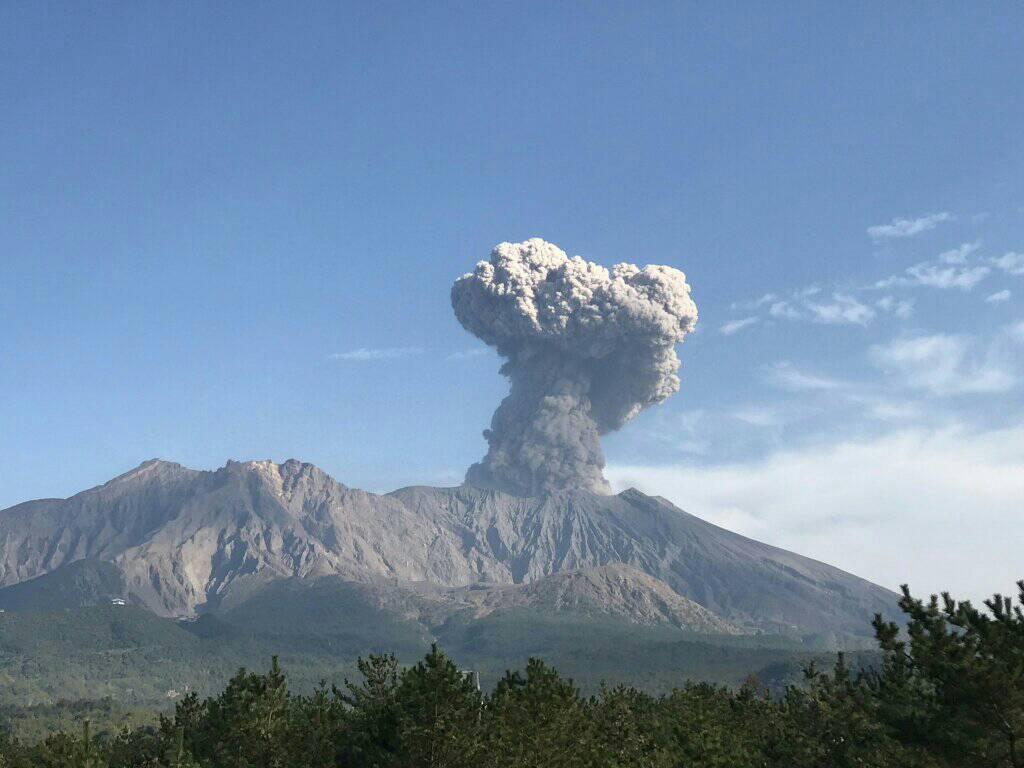
JMA reported ongoing eruptive activity at Minamidake Crater (Aira Caldera’s Sakurajima volcano) during 18-25 March. An explosion at 1952 on 18 March produced an ash plume that rose 1.2 km above the crater rim and drifted SE and ejected large blocks 800-1,100 m from the vent. Very small eruptions and nighttime incandescence were observed at the summit crater during other days of the report period. The Alert Level remained at 3 (on a 5-level scale), and the public was warned to stay 2 km away from both craters.
The Aira caldera in the northern half of Kagoshima Bay contains the post-caldera Sakurajima volcano, one of Japan’s most active. Eruption of the voluminous Ito pyroclastic flow accompanied formation of the 17 x 23 km caldera about 22,000 years ago. The smaller Wakamiko caldera was formed during the early Holocene in the NE corner of the caldera, along with several post-caldera cones. The construction of Sakurajima began about 13,000 years ago on the southern rim and built an island that was joined to the Osumi Peninsula during the major explosive and effusive eruption of 1914. Activity at the Kitadake summit cone ended about 4,850 years ago, after which eruptions took place at Minamidake. Frequent eruptions since the 8th century have deposited ash on the city of Kagoshima, located across Kagoshima Bay only 8 km from the summit. The largest recorded eruption took place during 1471-76.
Sources : Agence météorologique japonaise (JMA) , GVP.
Photo : Rizal M.
Costa Rica , Poas :
Latitude: 10.2
Longitude: -84,233
Altitude: 2,687 meters
Activity observed:
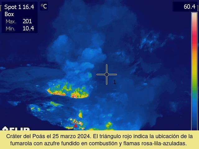
A small eruption was recorded by a network of seismographs and infrasound sensors on March 25, 2024 at 3:28 p.m. local time. Fumarolic degassing remains strong and vigorous through the fumaroles that lie at the almost dry bottom of the active crater. The seismic signal of volcanic tremor with frequencies between 0.8 and 4 Hz continues to be recorded continuously. This tremor is associated with the strong release of jets or jets of vapors, gases and aerosols through narrow fumarole ducts, which produces a loud noise in the fumarole vents. On March 25, the temperature of the fumarole, which features glowing light and pink-lilac-blue flames, was measured remotely with an infrared camera, recording 302 degrees Celsius. The SO2 concentration at Visitor’s Viewpoint recorded a maximum of 3 parts per million this morning according to the ExpoGAS sensor. Meanwhile, the MultiGAS system located on the western rim of the crater indicates gas ratios around stable values, SO2/CO2 between 0.3 and 0.9 and H2S/SO2 between 0.2 and 0.6.
Between March 22 and 25, 2024, the SENTINEL 5 satellite detected significant quantities of SO2 gas emitted by Poás: on March 22, 277 tons and on March 25, 252 tons. Several officials from the Poás Volcano National Park and neighbors in the vicinity of the volcano to the west have reported health problems in recent days, especially at night: headaches, nausea, irritation of the mucous membranes (eyes, nose, mouth, skin), nosebleeds. It is recommended to take measures to minimize or avoid health effects, such as reducing exposure time to gases and volcanic particles, sleeping in spaces with quality air, and using masks to protect the respiratory system from gases and particles.
Environmental conditions:
The predominant wind direction is from the South-South-West with a speed of 8 km/h (IMN). The summit of Poás remains clear.
Activity Level: Warning (2)
Source : Ovsicori.