January 31 , 2024 .
Italy , Stromboli :
WEEKLY BULLETIN, from January 22, 2024 to January 28, 2024. (issue date January 30, 2024)
SUMMARY STATEMENT OF ACTIVITY
In light of the monitoring data, it appears:
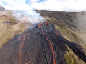
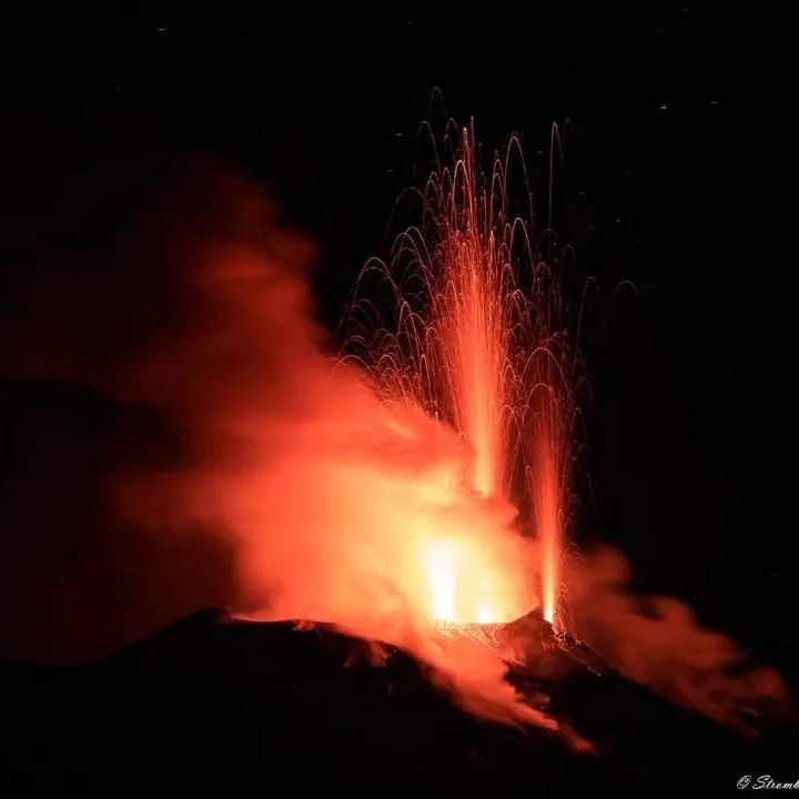
1) VOLCANOLOGICAL OBSERVATIONS: Normal Strombolian activity was observed during this period. The total hourly frequency fluctuated between average values (8-11 events/h). The intensity of the explosions was low in the North crater area and variable from weak to medium in the South-Central area.
2) SISMOLOGY: The monitored seismological parameters do not show significant variations.
3) GROUND DEFORMATIONS: The island’s ground deformation monitoring networks showed no significant changes to report for the period under review.
4) GEOCHEMISTRY: SO2 flux at medium level
CO2 flux in the summit zone: there are no updates.
C/S ratio in the plume: there are no updates.
The helium isotope ratio in the thermal aquifer shows high values (sampling on January 22, 2024).
CO2 flux in Scari: stable values at average levels of 110 g/m2day
5) SATELLITE OBSERVATIONS: Thermal activity observed by satellite was generally weak.
VOLCANOLOGICAL OBSERVATIONS
During the observed period, the eruptive activity of Stromboli was characterized through the analysis of images recorded by the INGV-OE surveillance cameras at altitude 190m (SCT-SCV) and
Point dei Corvi (SPCT). The explosive activity was mainly produced by 2 (two) eruptive vents located in the North area of the crater and by 1 (one) vent located in the South Central area.
It should be noted that the two cameras at altitude 190m, after the technical intervention, became continuously active again from 4:53 p.m. UTC on January 22.
Observations of explosive activity captured by surveillance cameras
In the area of the North crater (N), with a vent located in sector N1 and a vent located in sector N2, low intensity explosive activity (less than 80 m in height) was observed. The products emitted in the eruption were mainly coarse materials (bombs and lapilli). The average frequency of explosions fluctuated between less than 1 and 4 events/h.
In the South-Central (CS) zone, sectors S1 and C did not show significant activity while in sector S2 the explosions showed variable intensity from low to medium (less than 150 m in height) emitting fine materials sometimes mixed with coarse ones. The average frequency of explosions varied between 6 and 8 events/h.
Source : INGV
Photo : Stromboli stati d’animo
Italy / Sicily , Etna :
WEEKLY BULLETIN, from January 22, 2024 to January 28, 2024. (issue date January 30, 2024)
SUMMARY STATEMENT OF ACTIVITY
In light of the monitoring data, it appears:
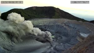
1) VOLCANOLOGICAL OBSERVATIONS: Degassing activity at the Bocca Nuova crater and at the South-East crater.
2) SEISMOLOGY: Low seismic activity due to fracturing. Average amplitude of the volcanic tremor at mid-level.
3) INFRASOUND: Moderate infrasound activity with sources located near the Bocca Nuova crater.
4) GROUND DEFORMATIONS: Over the past week, ground deformation monitoring networks have not recorded any significant changes.
5) GEOCHEMISTRY: SO2 flux at medium level
The soil CO2 flux presents average values.
The partial pressure of CO2 dissolved in groundwater presents values included in seasonal variability.
The helium isotope ratio shows high values.
VOLCANOLOGICAL OBSERVATIONS
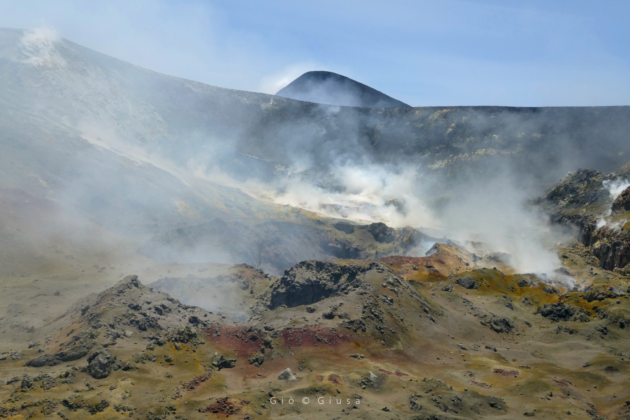
As observed since the beginning of January 2024, the state of activity of Etna continues to be characterized by degassing at variable rates mainly affecting the Bocca Nuova crater and secondarily the South-East crater (respectively BN and SEC) . Contrary to what was previously observed, the lightning which characterized the Bocca Nuova crater in a variable manner have not been detected since July 2023. This luminosity, observable during the night, was associated with the high temperature of the hot gases. emitted with an impulsive style (~ 500°c). As for the Voragine Crater and the North-East Crater, they remain obstructed with contained and limited degassing produced by modest zones of fumaroles.
Source : INGV
Photo : Gio Giusa
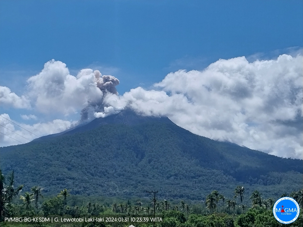
Indonesia , Lewotobi Laki Laki :
An eruption of Mount Lewotobi Laki occurred on Wednesday 31 January 2024 at 10:21 WITA with the height of the ash column observed at ±700 m above the summit (±2284 m above sea level). The ash column was observed to be white to gray in color with thick intensity, oriented towards the North. This eruption was recorded on a seismograph with a maximum amplitude of 47.3 mm and a duration of 113 seconds.
SEISMICITY OBSERVATIONS.
3 eruption/explosion earthquakes with an amplitude of 37 to 47.3 mm and earthquake duration of 49 to 113 seconds.
16 avalanche earthquakes with an amplitude of 3.7 to 29.6 mm and a duration of 24 to 143 seconds.
7 low-frequency earthquakes with an amplitude of 4.4 to 14.8 mm and an earthquake duration of 8 to 50 seconds.
4 hybrid/multi-phase earthquakes with an amplitude of 4.4 to 10.5 mm, and an earthquake duration of 9 to 13 seconds.
RECOMMENDATION
1. Communities around Mount Lewotobi Laki and visitors/tourists do not carry out any activities within a radius of 4 km from the center of the eruption of Mount Lewotobi Laki and within a sector of 5 km in the North-North-East direction and 6 km in the direction of the North-East sector.
2. The public should remain calm and follow the instructions of the regional government and not believe rumors whose origin is unclear.
Source et photo : Magma Indonésie.
Colombia , Puracé – Los Coconucos Volcanic Range :
Weekly bulletin of the activity of the Puracé volcano – Los Coconucos volcanic chain
From the monitoring of the activity of the VOLCANIC CHAIN PURACE VOLCANO – LOS COCONUCOS, the MINISTRY OF MINES AND ENERGY, through the COLOMBIAN GEOLOGICAL SERVICE (SGC), reports that:
During the week of January 23-29, 2024, seismic activity increased in number of earthquakes and seismic energy released compared to the previous week. The fracture earthquakes were mainly located less than 4 km deep between the Puracé and Piocollo volcanoes, with low magnitudes; while those associated with fluids were mainly located less than 1 km on the western flank of the Puracé volcano, with very low magnitudes. The appearance of seismicity possibly associated with the mobility of magma within the volcanic edifice emerged for 57 minutes on the 29th at 1:57 a.m. (local time), with no effects observed on the surface.
Likewise, localized deformations continued to be recorded between the Puracé and Curiquinga volcanoes. Carbon dioxide (CO2) values continue to fluctuate; However, they remain higher than the reference values of this volcano. On the other hand, stable values were recorded in the sulfur dioxide (SO2) flux.
The images obtained using the installed cameras show that high degassing of the volcanic system is maintained, both inside the crater and in the external lateral fumarole (northwest flank of the volcanic edifice).
The other parameters measured and used for the diagnosis of volcanic activity showed no notable changes during the period evaluated.
The alert status for volcanic activity remains at: YELLOW ALERT: ACTIVE VOLCANO WITH CHANGES IN THE BEHAVIOR OF THE BASE LEVEL OF MONITORED PARAMETERS AND OTHER MANIFESTATIONS.
Source et photo : SGC
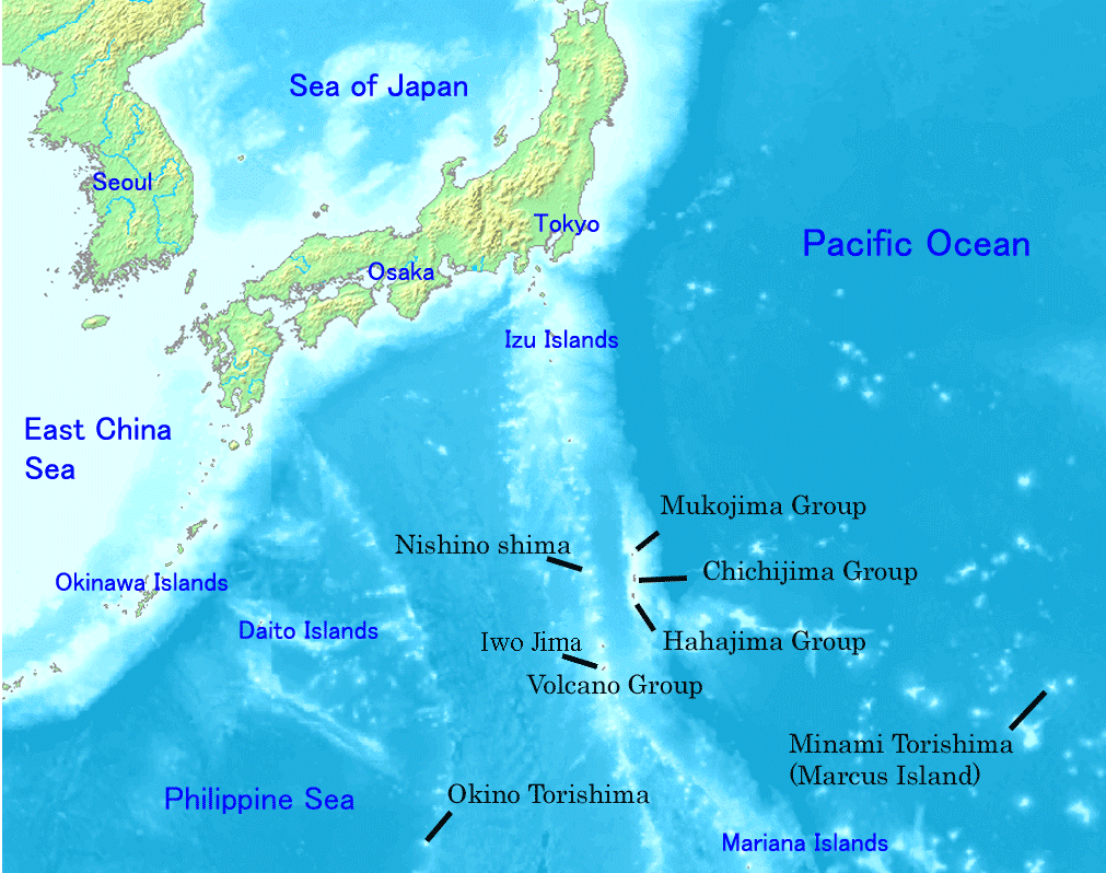
Japan , Iwo Jima :
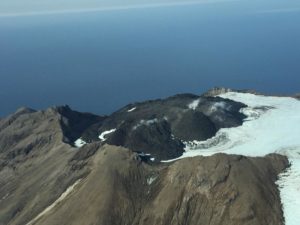
A new volcanic island appeared off the coast of Japan on January 22, 2024.
In the second half of October 2023, an underwater volcano located in the Pacific Ocean generated an eruption which, within a week, created a new small island in Japan. The island is located approximately 1,200 km southeast of Tokyo and less than a kilometer off the coast of the volcanic island of Ioto, one of the Ogasawara islands (and in particular the group of islands known as name of Volcano Islands). The island of Ioto is better known as Iwo Jima and is famous because it was the scene of a major battle during World War II between Japanese troops and American forces, which prevailed over the Japanese .
Geodynamic context and characteristics of eruptive activity
The geodynamic context in which the eruption occurs is characterized by subduction volcanism, in which the Pacific plate plunges beneath that of the Philippines. The Ogasawara Islands, made up of numerous tuff cones, are located within an approximately 9 km wide underwater caldera, affected by frequent eruptions over the last century (such as those of 2012-13 and 2021) . In general, it is an extremely seismically and volcanically active area.
The explosive eruption that occurred in October 2023 lasted about a month and a half and did not cause any damage to the main island of Ioto. It produced ash, pumice and dark waste which, when accumulating, formed an island approximately 169 m high. During the eruption, frequent explosions occurred in which ejected material reached a height of approximately 800 meters above the eruptive vent. Floating brown pumice stones have been observed in the water around the island. The explosions with the emission of ash and waste were accompanied by emissions of gas and water vapor which formed whitish plumes.
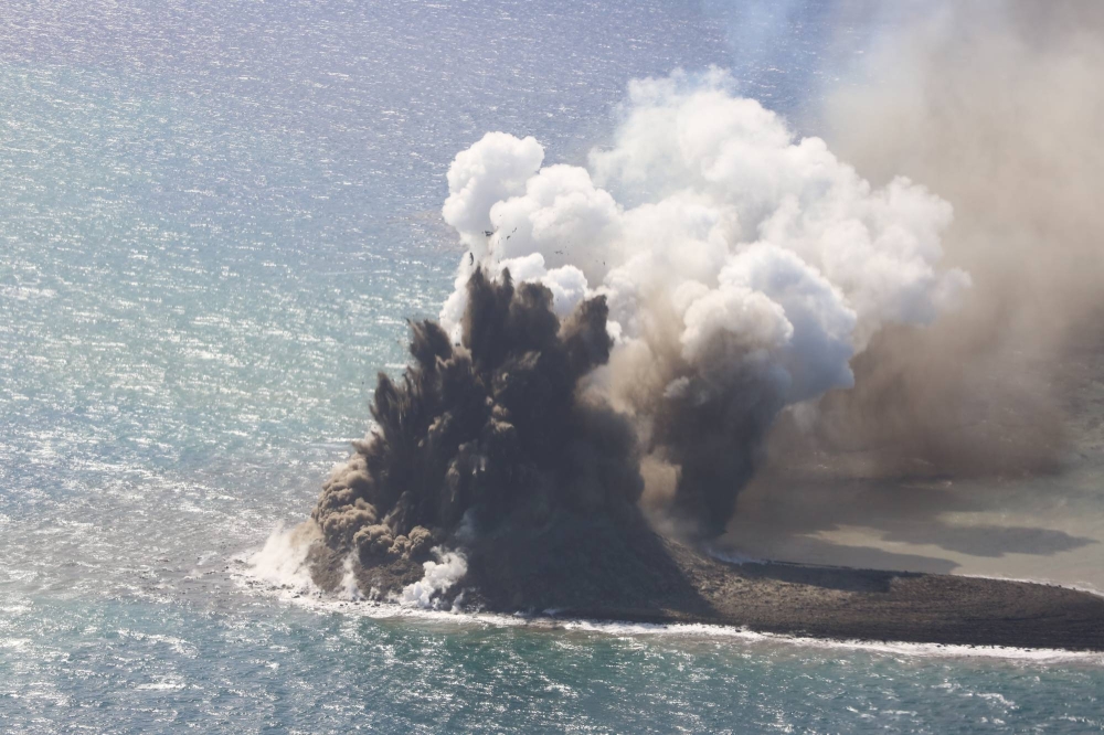
Black ash explosion from a newly formed volcanic island near Ioto/Iwo Jima on November 3, 2023. Courtesy of Setsuya Nakada (Center for Integrated Volcano Research, NIED Japan).
Erosion of the new island
Once emerged, the new island was intensely eroded by wave movement which significantly changed its shape from circular to elongated (approximately 500 m in length). Due to the processes of erosion and deposition, the morphology changed to the point that the northern end of the new island almost joined the main island of Ioto. Currently, more than a month after the end of the eruption, the area is still subject to intense underwater degassing.
This type of eruption is called surtseyenne. Typical of shallow seabeds, Surtseyan eruptions are generally characterized by high explosiveness due to the interaction between magma and water. The name derives from the island of Surtsey, located off the south coast of Iceland, formed between 1963 and 1967 following an underwater eruption. At the end of the eruption the island measured 175 m high with an area of more than 2 km2 and was made up of pyroclastic deposits and lava flows. Since then, the island has been subject to wave erosion which has considerably reduced its size.
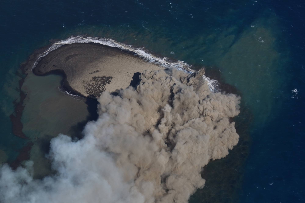
The newly formed island near Ioto/Iwo Jima seen from an airplane on November 3, 2023. Courtesy of Setsuya Nakada (Center for Integrated Volcano Research, NIED Japan).
Precedents in Italy
The events just described recall the well-known event that occurred in 1831 in the Strait of Sicily, when an underwater eruption gave life to the famous Ferdinandea Island, about 50 km from the southern coast of Sicily. . Even then, within a few months, the island was completely eroded by the movement of the waves.
Currently, the volcanic cone that gave life to Ferdinandea Island is located at a depth of 9 meters below sea level, constituting a shoal in the middle of the sea, largely colonized by gorgonians and corals and abundantly inhabited by local fauna.
Source : INGV Vulcani / Danilo Cavallaro
Photos : Wikipedia , Setsuya Nakada / Centre de recherche intégrée sur les volcans, NIED Japon