December 07 , 2023.
Indonesia , Marapi :
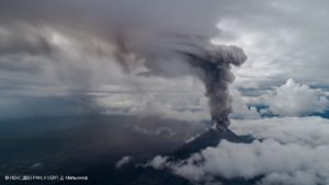
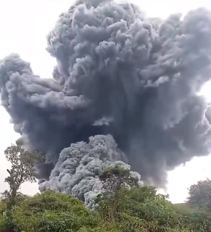
An explosive eruption from Marapi (on Sumatra) began at 14h54 local time (Western Indonesian Time, or WIB; 07h54 UTC) on 3 December, as reported by PVMBG and the National Disaster Management Agency’s (BNPB) Operations and Control Center (Pusdalops). At that time 75 people were known to be hiking on the volcano, having registered at either the Batu Palano entrance in Agam Regency or the Koto Baru entrance in Tanah Dara Regency. News reports late on the evening of 5 December indicated that rescue teams had accounted for all of the climbers, with officials reporting 23 deaths and 52 survivors, most of whom had suffered burns along with other injuries.
PVMBG reports and Volcano Observatory Notices for Aviation (VONAs) stated that the initial eruption lasted 4 minutes and 41 seconds, producing a dense dark gray ash plume that rose 3 km above the vent (5.9 km a.s.l.) and drifted E. The eruption was also accompanied by a roaring sound and a pyroclastic flow near the N flank that descended as far as 3 km. The Aviation Color Code was raised from Orange to Red. Tephra fall was reported within 6 km from the vent, and ash as far as 13 km away. Thick ashfall was reported as of 17h42 WIB in the Nagari Lasi area within the Canduang District of Agam Regency, and less intense ashfall was reported in the Sungai Pua District. By 07h28 WIB on 4 December, tephra consisting of mainly ash and some larger clasts described as “gravel or stones” had been reported in the Canduang, Sungai Pua, Ampek-Ampek, Malalak, Banuhampu, Tilatang Kamang, Baso, Tanjung Raya, Lubuk Basung, IV Koto, Matur, Tanjung Mutiara, Palembayan, and Kamang Magek subdistricts.
Prior to the eruption, during 29 November-2 December, summit views were blocked by weather clouds and recorded seismicity consisted of typical volcano-tectonic (VT) earthquakes; the eruption was not preceded by increased seismicity. Overall on 3 December the seismic network recorded 36 eruption events starting with the 14h54 WIB activity. Another 10 eruption events were recorded on 4 December, including an explosion at 08h22 that produced a dense gray-to-black ash plume that rose as high as 800 m above the vent and drifted SW. The Aviation Color Code was lowered from Red to Orange. The seismic network recorded six additional eruption signals during 5 December, though summit views were often blocked by weather clouds.
The Alert Level remained at 2 (on a scale of 1-4) and the public was warned to stay at least 3 km away from the crater in all directions. There were no evacuations, but people within the Canduang, Sungai Pua, Ampek Angkek, and Malalak districts were advised to avoid outdoor activities and wear masks. With support from the West Sumatra Provincial Government, the Agam Regency government activated health centers to help those affected by ashfall.
Sources: Pusat Vulkanologi dan Mitigasi Bencana Geologi (PVMBG, also known as CVGHM), Badan Nacional Penanggulangan Bencana (BNPB), Antara News, Channelnewsasia.com , GVP.
Photos : Wulkany swiata , auteur inconnu via objectif volcans
Iceland , Reykjanes Peninsula :
More magma propogation likely
The likelihood of a volcanic eruption over the magma intrusion has significantly decreased, but other dangers persist in the affected area.
Updated 6. December at 18:00 UTC
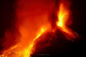
Latest geodetic modelling results suggests that the magma inflow to the dike that formed on November 10 has likely ceased. The chances of an eruption happening along the dike at this time have therefore significantly decreased. However, magma accumulation continues beneath Svartsengi.
The ongoing activity at Svartsengi, which began in October, is not yet over and a new chapter may have begun with an increased chance of a new magma propagation and, subsequently, increased likelihood of an eruption.
As previously mentioned, the dike beneath Grindavík was fed by magma accumulating beneath Svartsengi. It is likely that this sequence of events will repeat. When looking at the overall pattern with repeated magma accumulation, it can be estimated that the next magma propagation from Svartsengi might be on a smaller scale than the one previously formed on November 10. A magma propagation could persist for several hours or days with an increased risk due to seismic activity and deformation during that period.
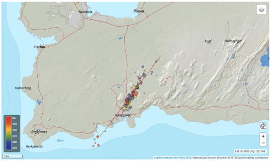
Signs of a magma propagation include a sudden increase in seismic activity and rapid changes in ground deformation. These signs can be observed on instruments several hours before the magma propagation is likely to pose a threat to Svartsengi or Grindavík. If a magma propagation occurs, the Icelandic Meteorological Office will immediately activate response plans for public safety.
Following a magma propagation, the likelihood of an eruption increases. As mentioned above, it is most likely that magma will propagate from Svartsengi into the previously formed dike on November 10. Making it the most likely area for an eruption.
It is not possible to estimate when the next magma propagation will occur. The uncertainty is considerable, and a magma propagation could happen in the next few days or possibly after several months.
The Icelandic Meteorological Office continues to monitor the area closely and continues to monitor any signs of magma propagation and other changes that could pose further danger in the area near Svartsengi and Grindavík.
Source et photo : IMO
Indonesia , Anak Krakatau :
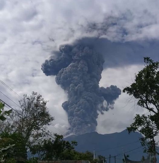
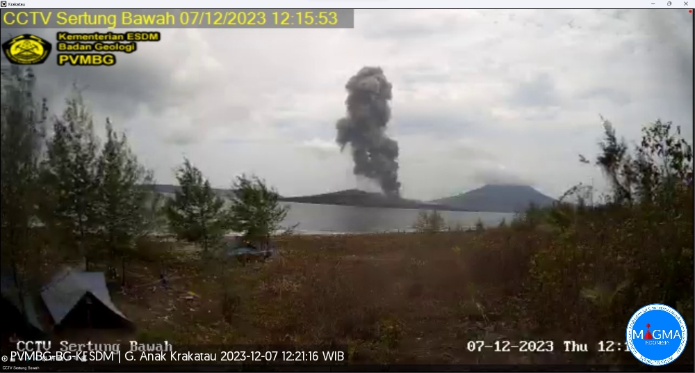
An eruption of Anak Krakatau occurred on Thursday, December 7, 2023 at 12:15 WIB. The height of the eruptive column was observed to be ±1,200 m above the peak (±1,357 m above sea level). The ash column was observed to be gray to black in color with thick intensity, oriented towards the North-East. The eruption was recorded on a seismograph with a maximum amplitude of 49 mm and a duration of 73 seconds.
VOLCANO OBSERVATORY NOTICE FOR AVIATION – VONA
Issued : December 07 ,2023
Volcano : Anak Krakatau (262000)
Current Aviation Colour Code : ORANGE
Previous Aviation Colour Code : orange
Source : Anak Krakatau Volcano Observatory
Notice Number : 2023KRA125
Volcano Location : S 06 deg 06 min 07 sec E 105 deg 25 min 23 sec
Area : Lampung, Indonesia
Summit Elevation : 502 FT (157 M)
Volcanic Activity Summary :
Eruption with volcanic ash cloud at 05h15 UTC (12h15 local).
Volcanic Cloud Height :
Best estimate of ash-cloud top is around 4342 FT (1357 M) above sea level or 3840 FT (1200 M) above summit. May be higher than what can be observed clearly. Source of height data: ground observer.
Other Volcanic Cloud Information :
Ash cloud moving to northeast. Volcanic ash is observed to be gray to dark. The intensity of volcanic ash is observed to be thick.
Remarks :
Eruption recorded on seismogram with maximum amplitude 49 mm and maximum duration 73 second.
Source et photo : Magma Indonésie .
Japan , Sakurajima :
LJMA reported ongoing activity at Minamidake Crater (Aira Caldera’s Sakurajima volcano) during 29 November-5 December, with very small eruptions and crater incandescence observed nightly. One volcanic earthquake was recorded on 3 November, and another on 4 November. A field survey conducted on 30 November detected an extremely high SO2 rate of 4,200 tonnes per day. The Alert Level remained at 3 (on a 5-level scale), and the public was warned to stay 2 km away from both craters.
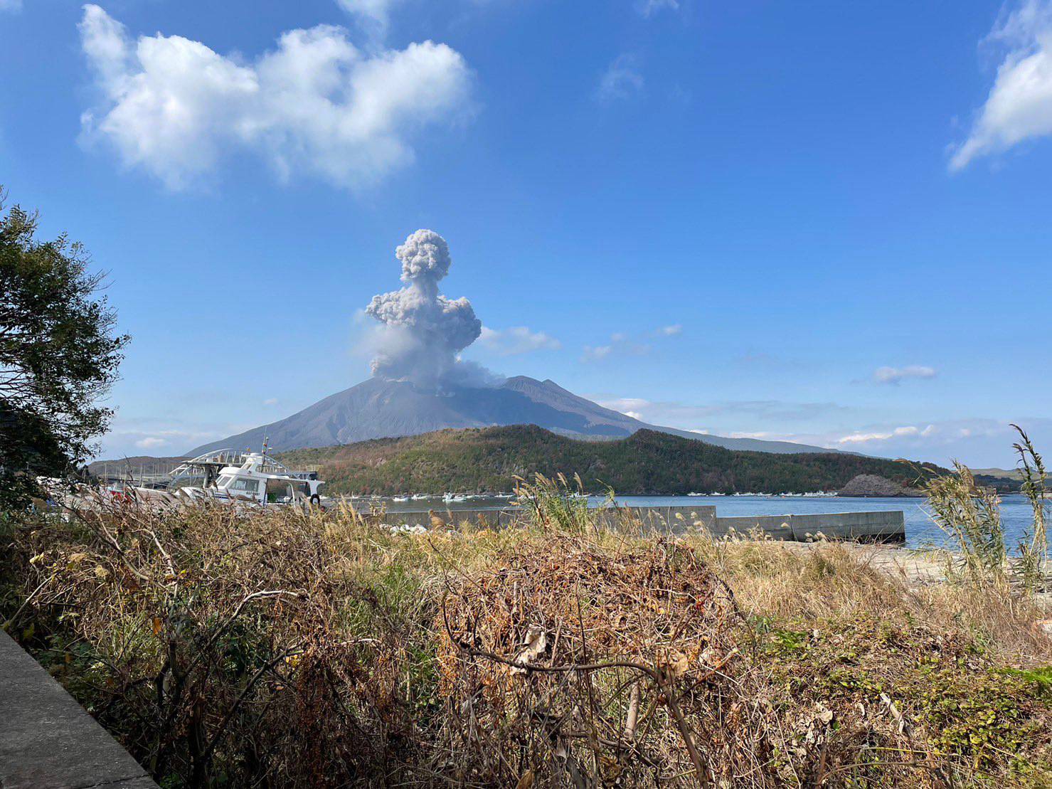
The Aira caldera in the northern half of Kagoshima Bay contains the post-caldera Sakurajima volcano, one of Japan’s most active. Eruption of the voluminous Ito pyroclastic flow accompanied formation of the 17 x 23 km caldera about 22,000 years ago. The smaller Wakamiko caldera was formed during the early Holocene in the NE corner of the caldera, along with several post-caldera cones. The construction of Sakurajima began about 13,000 years ago on the southern rim and built an island that was joined to the Osumi Peninsula during the major explosive and effusive eruption of 1914. Activity at the Kitadake summit cone ended about 4,850 years ago, after which eruptions took place at Minamidake. Frequent eruptions since the 8th century have deposited ash on the city of Kagoshima, located across Kagoshima Bay only 8 km from the summit. The largest recorded eruption took place during 1471-76.
Source: Japan Meteorological Agency (JMA), GVP
Photo : @walksamurai via Patrice Zwenger ( archive)
Colombia , Nevado del Ruiz :
Weekly bulletin on the activity of the Nevado del Ruiz volcano
Regarding the monitoring of the activity of the NEVADO DEL RUIZ VOLCANO, the MINISTRY OF MINES AND ENERGY, through the COLOMBIAN GEOLOGICAL SERVICE (SGC), reports that:
Compared to the previous week, the main variations in activity were:
– Seismicity associated with the fracturing of rocks within the volcanic edifice increased in the number of earthquakes recorded and slightly decreased in the seismic energy released. The seismicity was located mainly between 4 and 5 km west-southwest of the Arenas crater and, to a lesser extent, in the crater itself and in a scattered manner, on the other flanks of the volcano (up to 14 km from the crater). . The depth of the earthquakes was between less than 1 and 7 km from the summit of the volcano. The maximum magnitude was 1.5, corresponding to the earthquake recorded on December 3 at 2:21 a.m., located approximately 5 km west-southwest of the Arenas crater, at a depth of 4 km. Occasionally, seismicity linked to the activity of the lava dome (protrusion or mound) located at the bottom of the crater has been recorded. This type of seismicity was of short duration and low energy level.
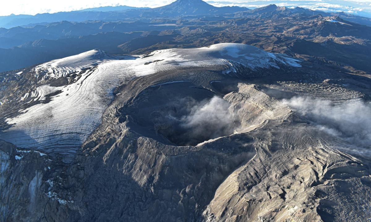
– Seismicity related to pulsatile emissions of gas and ash has decreased in the number of earthquakes recorded and in seismic energy released, while seismicity associated with continuous emissions of gas and ash has increased in recent days. The energy levels of this type of seismicity ranged from low to moderate. Additionally, some seismic signals were linked to changes in the relative temperature of the emitted material. Both phenomena were confirmed thanks to the cameras used to monitor the volcano.
When monitoring surface activity from satellite monitoring platforms, several thermal anomalies linked to the increase in temperature at the bottom of Arenas Crater were detected, with energy levels that varied from low to high. Yesterday, December 4, the thermal anomaly report was obtained with the highest energy level recorded since this parameter was monitored on the volcano (2007). Likewise, in recent weeks there has been a greater recurrence of thermal anomalies of moderate energy levels in the crater with a gradual trend towards higher energy levels.
Source et photo : SGC