October 15 , 2023.
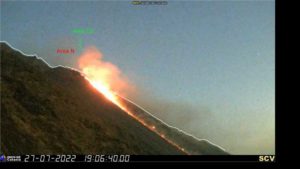
Indonesia , Semeru :
VOLCANO OBSERVATORY NOTICE FOR AVIATION – VONA
Issued : October 14 , 2023 .
Volcano : Semeru (263300)
Current Aviation Colour Code : RED
Previous Aviation Colour Code : orange
Source : Semeru Volcano Observatory
Notice Number : 2023SMR354
Volcano Location : S 08 deg 06 min 29 sec E 112 deg 55 min 12 sec
Area : East java, Indonesia
Summit Elevation : 11763 FT (3676 M)
Volcanic Activity Summary :
Eruption with volcanic ash cloud at 22h11 UTC (05h11 local).
Volcanic Cloud Height :
Best estimate of ash-cloud top is around 12723 FT (3976 M) above sea level or 960 FT (300 M) above summit. May be higher than what can be observed clearly. Source of height data: ground observer.
Other Volcanic Cloud Information :
Ash cloud moving from southeast to south. Volcanic ash is observed to be white to gray. The intensity of volcanic ash is observed to be medium.
Remarks :
Eruption recorded on seismogram with maximum amplitude 22 mm and maximum duration 106 second.
Source : Magma Indonésie
Photo : Andi volcanist
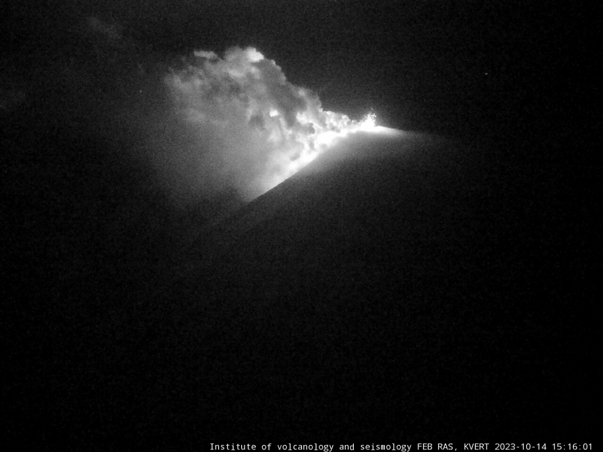
Kamchatka , Klyuchevskoy :
VOLCANO OBSERVATORY NOTICE FOR AVIATION (VONA)
Issued: October 14 , 2023 .
Volcano: Klyuchevskoy (CAVW #300260)
Current aviation colour code: ORANGE
Previous aviation colour code: orange
Source: KVERT
Notice Number: 2023-110
Volcano Location: N 56 deg 3 min E 160 deg 38 min
Area: Kamchatka, Russia
Summit Elevation: 4750 m (15580 ft)
Volcanic Activity Summary:
The summit explosive-effusive eruption of the volcano continues. Against the background of explosive activity of the Strombolian type (lava fountaining in the volcanic crater), the lava flows continue to effuse along the Apakhonchichsky chute on the southeastern slope of the volcano. Satellite data by KVERT showed a gas-steam plume containing some amount of ash is extending for 63 km to the east of the volcano.
The summit explosive-effusive eruption of the volcano continues. Ash explosions up to 7-8 km (23,000-26,240 ft) a.s.l. could occur at any time. Ongoing activity could affect international and low-flying aircraft.
Volcanic cloud height:
4000-4500 m (13120-14760 ft) AMSL Time and method of ash plume/cloud height determination: 20231014/2300Z – Himawari-9 14m15
Other volcanic cloud information:
Distance of ash plume/cloud of the volcano: 63 km (39 mi)
Direction of drift of ash plume/cloud of the volcano: E / azimuth 88 deg
Time and method of ash plume/cloud determination: 20231014/2300Z – Himawari-9 14m15
Source : Kvert
Photo : IVS FEB RAS, KVERT
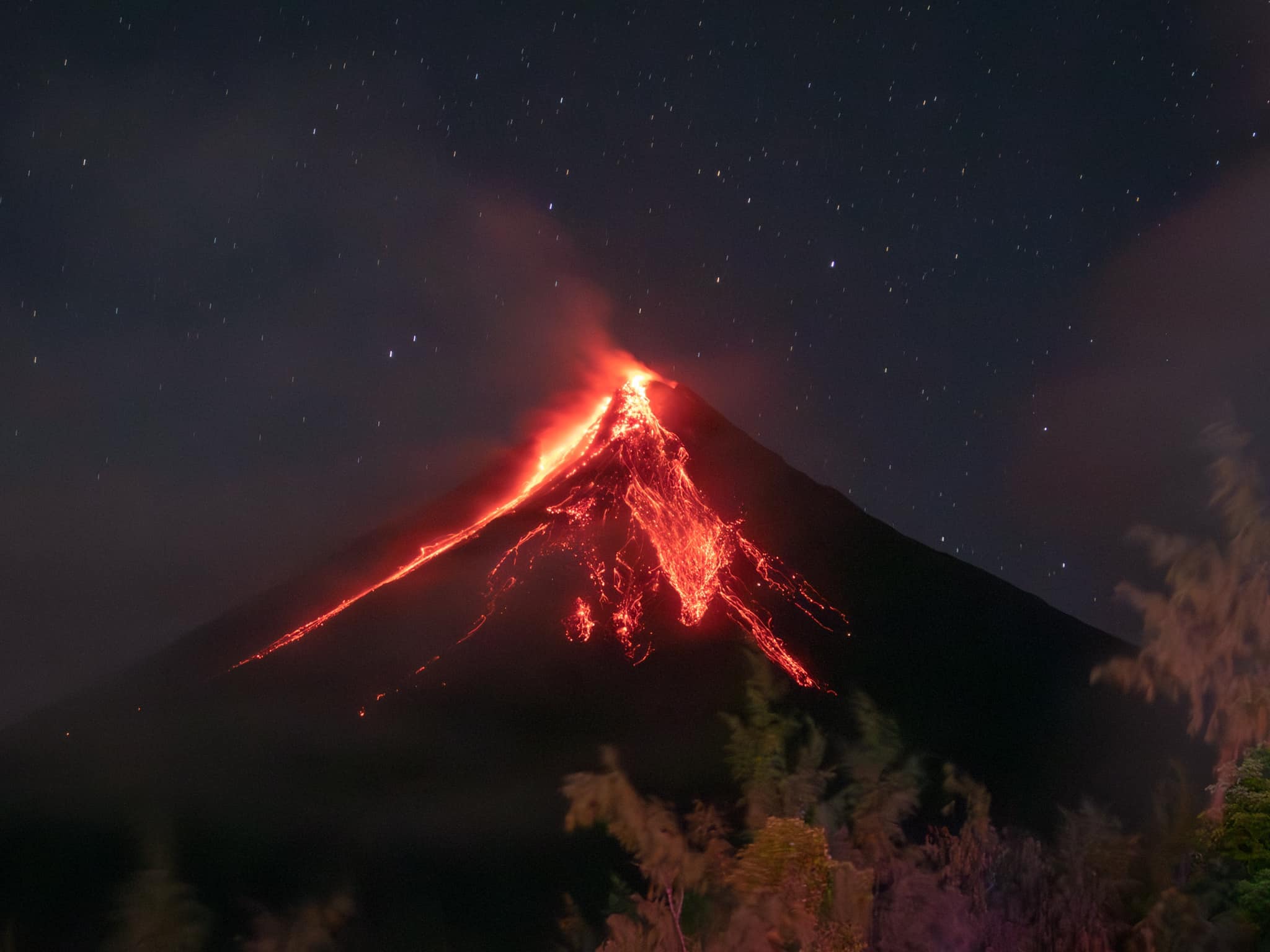
Philippines , Mayon :
MAYON VOLCANO BULLETIN 15 October 2023 8:00 AM
In the past 24-hour period, the Mayon Volcano Network recorded thirty-four (34) volcanic earthquakes including thirty (30) tremor events having a duration of one (1) minute to thirty-two (32) minutes, one (1) pyroclastic density current event, and one hundred and five (105) rockfall events. The lava flows have maintained their advances to approximately 3.4 kilometers in Bonga (southeastern), 2.8 kilometers in Mi-isi (south), and 1.1 kilometers in Basud (eastern) Gullies. Rockfalls and PDCs generated by the collapse of the summit dome deposited debris still within four (4) kilometers of the crater. Volcanic sulfur dioxide (SO2) emission averaged 1,018 tonnes/day on 14 October 2023.
Short-term observations from electronic tilt and GPS monitoring indicate inflation of the northwestern upper and middle slopes since late July 2023 and October 2023, respectively. Longer-term ground deformation parameters from EDM, precise leveling, continuous GPS, and electronic tilt monitoring indicate that Mayon is still generally inflated relative to baseline levels.
Alert Level 3 is maintained over Mayon Volcano, which means that it is currently in a relatively high level of unrest, and hazardous eruption within weeks or even days could still be possible.
Source : Phivolcs
Photo : Rick Estillomo
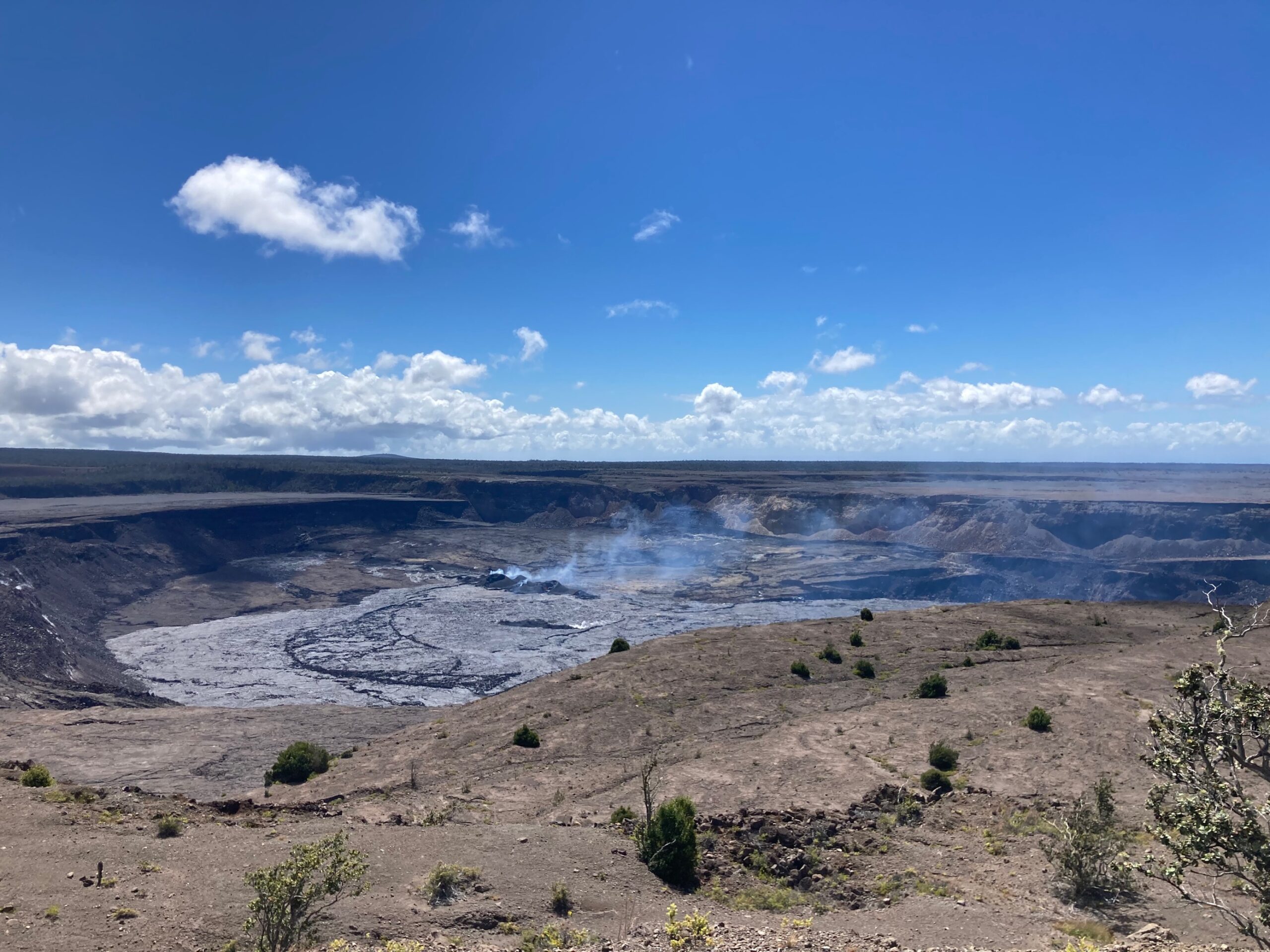
Hawaii , Kilauea :
Saturday, October 14, 2023, 9:26 AM HST (Saturday, October 14, 2023, 19:26 UTC)
19°25’16 » N 155°17’13 » W,
Summit Elevation 4091 ft (1247 m)
Current Volcano Alert Level: ADVISORY
Current Aviation Color Code: YELLOW
Activity Summary:
Kīlauea volcano is not erupting. Earthquake and ground deformation rates beneath the southern part of Kīlauea’s summit caldera and extending to the southwest have decreased dramatically over the past 48 hours, suggesting the intrusive event that began last week is coming to an end.
Summit Observations:
The major intrusive event that has been ongoing beneath the area extending from the southern part of Kīlauea caldera southwest to the Koaʻe fault zone appears to have slowed significantly or stopped. A dramatic drop in earthquakes, from a peak of over 250 per day last week, to only 27 recorded in the past 24 hours. These earthquakes were at depths of 1-4 km (0.6-2.5 mi) beneath the surface.
Summit tiltmeters recorded an abrupt change in tilt magnitude and direction, in the last 48 hours, away from the seismically active area, thus signaling ground deformation associated with the intrusive event ceased. These observations suggest that new magma supply to the intrusion below the surface south of Kīlauea’s summit caldera has slowed greatly or stopped. However, inflation at the summit of Kīlauea remains high and has nearly returned to the level seen just before the last eruption on September 10th.
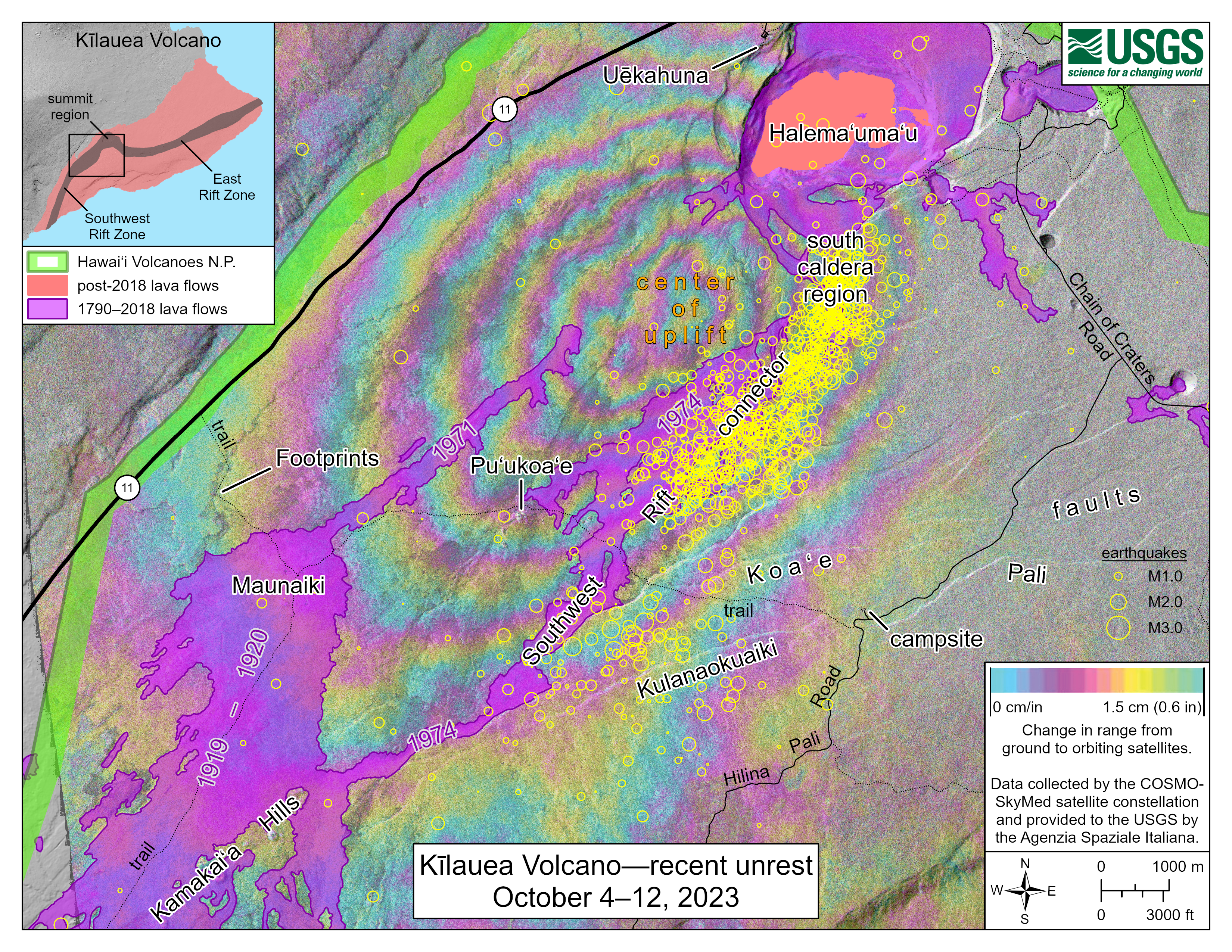
October 12, 2023—Summary map of intrusive activity at Kīlauea Volcano―October 4–12, 2023 | U.S. Geological Survey (usgs.gov)
Currently, the Uēkahuna summit tiltmeter located north of the caldera recorded very slight deflation over the past 24 hours. The Sand Hill tiltmeter, located just south of the caldera, is showing a flat tilt trend. Sulfur dioxide (SO2) emission rates remain low and were measured at a rate of about 100 tonnes per day on October 6. Other monitoring data streams, including webcam views, do not show any significant changes.
Inflation at the summit of Kīlauea remains high and has nearly returned to the level seen just before the last eruption on September 10th. Seismicity and ground deformation rates are likely to begin increasing again in the near future, and HVO continues to monitor the summit region of Kīlauea volcano closely.
Source : HVO
Photos : USGS/ M. Patrick , USGS .
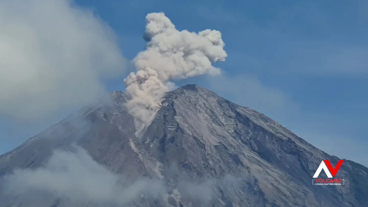
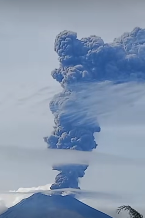
Mexico , Popocatepetl :
October 14, 11:00 a.m. (October 14, 5:00 p.m. GMT)
Activity from the last 24 hours
195 low intensity exhalations were detected, accompanied by water vapor, volcanic gases and sometimes ash. Additionally, 482 minutes of very low to low amplitude high frequency tremors were recorded.
At the time of this report, there is partial visibility of the volcano, an emission of water vapor, volcanic gases and light quantities of ash is observed in the northwest (NW) direction.
The Popocatépetl volcanic warning fire is in yellow phase 2.
The scenarios planned for this phase are:
A few small to moderate explosions
Appearance of tremors of variable amplitude
Light to moderate ash rain in surrounding towns and some more distant towns
Ejection of incandescent fragments within the exclusion radius of 12 kilometers
Lahars can be expected to appear in the ravines, due to the accumulation of ash on the slopes and their interaction with the rains expected in the coming weeks.
Possibility of pyroclastic flows not reaching populations.
Source : Cenapred.
Photo : volcan popocatepetl /FB