September 19 , 2023.
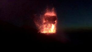
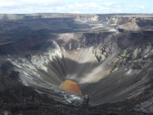
Hawaii , Kilauea :
Sunday, September 17, 2023, 10:16 AM HST (Sunday, September 17, 2023, 20:16 UTC)
19°25’16 » N 155°17’13 » W,
Summit Elevation 4091 ft (1247 m)
Current Volcano Alert Level: ADVISORY
Current Aviation Color Code: YELLOW
Activity Summary:
The Kīlauea summit eruption that began on September 10th stopped September 16th, and is unlikely to restart. No unusual activity has been noted along Kīlauea’s East Rift Zone or Southwest Rift Zone.
Summit Eruption Observations:
Eruption of lava from the fissure vents on the downdropped block of Kīlauea’s summit caldera stopped around noon , September 16, and there was no observable activity anywhere overnight or this morning. Yesterday morning, HVO field crews reported that active lava was no longer flowing onto Halemaʻumaʻu crater floor and was restricted to a ponded area north of the vents on the downdropped block. They observed lava spattering at the vents cease at approximately 11:15 am September 16. Overnight webcam views showed some incandescence across the eruption area as lava erupted over the past week continues to cool. Field observations are supported by geophysical data, which show that eruptive tremor (a signal associated with fluid movement) in the summit region decreased over September 15 and 16 and returned to pre-eruption levels by 5 p.m. HST on September 16.
Summit Observations:
Summit tilt was mildly inflationary most of the past 24 hours. Summit seismic activity is low with very few volcano tectonic earthquakes and tremor at background levels. Sulfur dioxide (SO2) emissions have also decreased to near background levels based upon the very weak plume visible this morning. Sulfur dioxide levels were measured at a rate of 800 tonnes per day September 16, while the eruption was waning. This value is down dramatically from the 190,000 tonnes per day measured just after the onset of the eruption on Sunday, September 10th, and is only slightly above the 100-200 tonnes typical of non-eruptive periods.
Source : HVO
Photo : Bruce Omori.
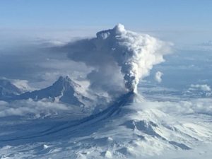
Philippines , Mayon :
MAYON VOLCANO BULLETIN 19 September 2023 8:00 AM
In the past 24-hour period, the Mayon Volcano Network recorded four (4) volcanic earthquakes, one hundred sixty (160) rockfall events, and three (3) pyroclastic density current or PDC events. The lava flows have maintained their advances to approximately 3.4 kilometers in Bonga (southeastern), 2.8 kilometers in Mi-isi (south), and 1.1 kilometers in Basud (eastern) gullies. Rockfalls and PDCs generated by collapses of the lava flow margins as well as of the summit dome deposited debris still within four (4) kilometers of the crater. Volcanic sulfur dioxide (SO2) emission averaged 959 tonnes/day on 18 September 2023
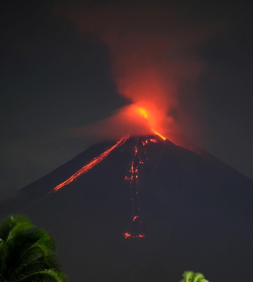
Short-term observations from electronic tilt and GPS monitoring indicate pronounced inflation of southeastern middle slopes since the beginning of August 2023. Longer-term ground deformation parameters from EDM, precise leveling, continuous GPS, and electronic tilt monitoring indicate that Mayon is still generally inflated relative to baseline levels.
Alert Level 3 is maintained over Mayon Volcano, which means that it is currently in a relatively high level of unrest and hazardous eruption within weeks or even days could still be possible.
Source : Phivolcs
Photo : Dex Baldon
Indonesia , Gamalama :
Press release on the volcanic activity of Mount Gamalama, September 19, 2023.
Gamalama Volcano is administratively located in the region of the town of Ternate, North Moluccas province. Gamalama Volcano is monitored visually and instrumentally from the Volcano Observation Post (PGA) located on Jl. Facei Sabia, Ternate Town, North Moluccas.
The seismicity of Mount Gamalama since January 2023 is dominated by distant tectonic earthquakes, local tectonic earthquakes and deep volcanic earthquakes (VA). Deep volcanic earthquakes (VA) are generally recorded at 1 to 2 events per day. The smoke escaping from the crater is generally observed to be white, thin to thick, at a height of 10 to 300 meters above the summit. The current activity level has been at Level II (WASPADA) since March 10, 2015. The character of the eruption generally occurs in the central crater with relatively short eruption precursors. The last eruption took place on October 4, 2018, beginning with the recording of 7 volcanic earthquakes 1 hour before the eruption. The height of the eruptive column reached 250 meters from the summit.
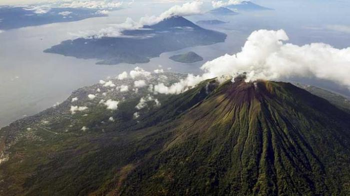
The latest developments on G. Gamalama’s activities until September 19, 2023 at 09:00 WIT are as follows:
There has been an increase in deep volcanic earthquakes (VA) since September 8, 2023. On September 8, 2023, 16 deep volcanic earthquakes were recorded and the average occurrence until September 18, 2023 was 9 events per day. Seismic swarms are observed to fluctuate and tend to increase. As of September 18, 2023, 6 burst earthquakes, 7 deep volcanic earthquakes, 14 local tectonic earthquakes, and 18 distant tectonic earthquakes have been recorded.
From September 8 to 18, 2023, crater emission activity saw fine white crater smoke rising 25 to 100 meters high, with weak to moderate winds from the West-Southwest, North and Northeast.
In general, the activity of Mount Gamalama, September 8–19, 2023 at 09:00 WIT tends to fluctuate and is always dominated by deep volcanic earthquakes, local tectonic earthquakes, and distant tectonic earthquakes that are linked to regional tectonic activity around the Halmahera Islands.
Under conditions like those above, and given the characteristics of the Gamalama Volcano eruption precursors, the potential hazard most likely to occur is a phreatic eruption with the current threat of danger in the form of an ejection of material from the main crater impacting an area with a radius of 1.5 km from the center of the eruption. Light ash showers may occur with distance and intensity depending on wind direction and speed.
Based on the results of observations and analysis of visual and instrumental data until September 19, 2023 at 09:00 WIT, the activity level of Mount Gamalama remains at level II (WASPADA).
Source : PVMBG.
Photo : KOMPAS/HERU SRI KUMORO
Chile , Villarica :
Special Report on Volcanic Activity (REAV), La Araucanía and Los Ríos regions, Villarrica volcano, September 18, 2023, 01:48 a.m. local time (mainland Chile)
The National Geology and Mining Service of Chile (Sernageomin) announces the following PRELIMINARY information, obtained through the monitoring equipment of the National Volcanic Monitoring Network (RNVV), processed and analyzed at the Southern Andean Volcano Observatory (Ovdas):
On Monday, September 18, 2023, at 1:30 a.m. local time (04:30 UTC), monitoring stations installed near the Villarrica volcano recorded an earthquake associated with fluid dynamics inside the volcanic system (LP type).
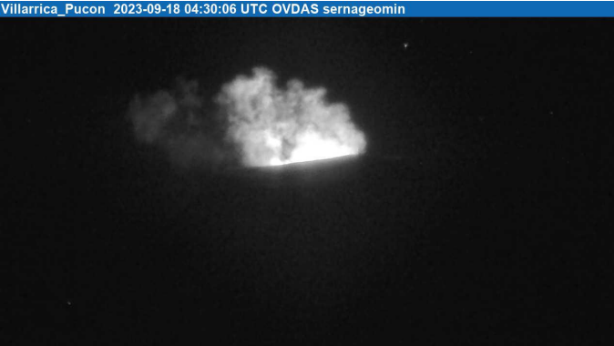
The characteristics of the earthquake, after its analysis, are as follows:
ORIGINAL TIME: 01:30 local time, (04:30 UTC).
REDUCED DISPLACEMENT: 87.19 (cm*cm)
The characteristics of the associated surface activity are as follows:
MAXIMUM HEIGHT OF THE EMISSION COLUMN: 120 m
OBSERVATIONS:
No changes in the seismic behavior of the volcano were recorded following the reported event. The IP camera observed incandescence and degassing from the crater.
The technical volcanic alert is maintained at the Yellow level.
Source et photo : Sernageomin.
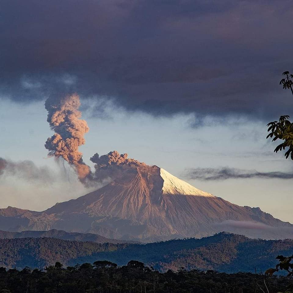
Ecuador , Sangay :
DAILY REPORT ON THE STATE OF THE SANGAY VOLCANO, Monday September 18, 2023.
Information Geophysical Institute – EPN.
Surface activity level: High, Surface trend: No changes
Internal activity level: High, Internal trend: No changes
Seismicity: From September 17, 2023, 11:00 a.m. to September 18, 2023, 11:00 a.m.:
The number of seismic events recorded at the reference station over the past 24 hours is shown below. The level of seismic activity of the volcano remains high.
Explosion Event (EXP): 559
Precipitation/Lahars:
No rain was recorded in the volcano area. **In the event of heavy rains, these could remobilize the accumulated materials, generating mud and debris flows which would descend the sides of the volcano and flow into adjacent rivers.**
Emissions/ash column:
Thanks to the GOES – 16 satellite system, it was possible to visualize a gas trail since the beginning of the day. This gas trail remained in the morning with a light ash load, with a height less than 800 meters above the crater level in the west direction.
Other monitoring parameters:
The FIRMS, MIROVA-MODIS and MIROVA-VIRS satellite systems report 6 thermal anomalies, 2 moderate thermal anomalies and 4 moderate anomaly alerts respectively over the last 24 hours.
Observation:
Yesterday afternoon the volcano remained completely cloudy, for the moment the volcano has cleared up allowing us to observe an incandescence at the level of the crater and the expulsion of material with their descent which reached up to 180m below the level of the crater.
Alert level: Orange.
Source : IGEPN.
Photo : Volcan Sangay