September 12 , 2023.
Hawaii , Kilauea :
HVO/USGS Volcanic Activity Notice
Current Volcano Alert Level: WATCH
Previous Volcano Alert Level: WARNING
Current Aviation Color Code: ORANGE
Previous Aviation Color Code: RED
Issued: Monday, September 11, 2023, 8:10 AM HST
Source: Hawaiian Volcano Observatory
Notice Number: 2023/H310
Location: N 19 deg 25 min W 155 deg 17 min
Elevation: 4091 ft (1247 m)
Area: Hawaii
Volcanic Activity Summary:
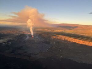
The eruption within Kīlauea’s summit caldera that began yesterday afternoon continues, with eruptive activity confined to the downdropped block and Halemaʻumaʻu crater. HVO is lowering Kīlauea’s volcano alert level from WARNING to WATCH because the style of eruption and fissure location have stabilized, the initial extremely high effusion rates have declined, and no infrastructure is threatened. Associated hazards are confined to the closed area established by Hawaiʻi Volcanoes National Park.
HVO is lowering Kīlauea’s aviation color code from RED to ORANGE because there is currently no threat of significant volcanic ash emission into the atmosphere outside of the hazardous closed area within Hawai‘i Volcanoes National Park. The eruption plume, composed largely of sulfur dioxide and minor volcanic particles, continues to rise to the base of the inversion level at about 8,000-10,000 feet (2,400-3,000 meters) above sea level. The plume concentration has decreased some due to the drop in effusion rate, but still remains high. Hazards associated with the eruption are limited and are described below.
Kīlauea’s summit eruption is expected to continue and remain confined to Kīlauea caldera within Hawai‘i Volcanoes National Park. HVO does not see any indication of activity migrating elsewhere on Kīlauea volcano and expects the eruption to remain confined to the summit region.
HVO will continue to monitor this activity closely and report any significant changes in future notices.
Monday, September 11, 2023, 8:55 AM HST (Monday, September 11, 2023, 18:55 UTC)
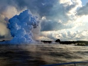
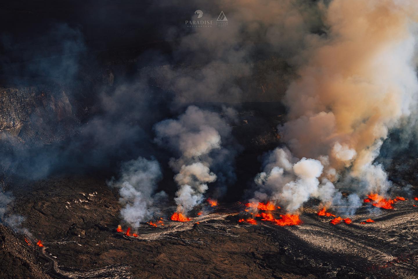
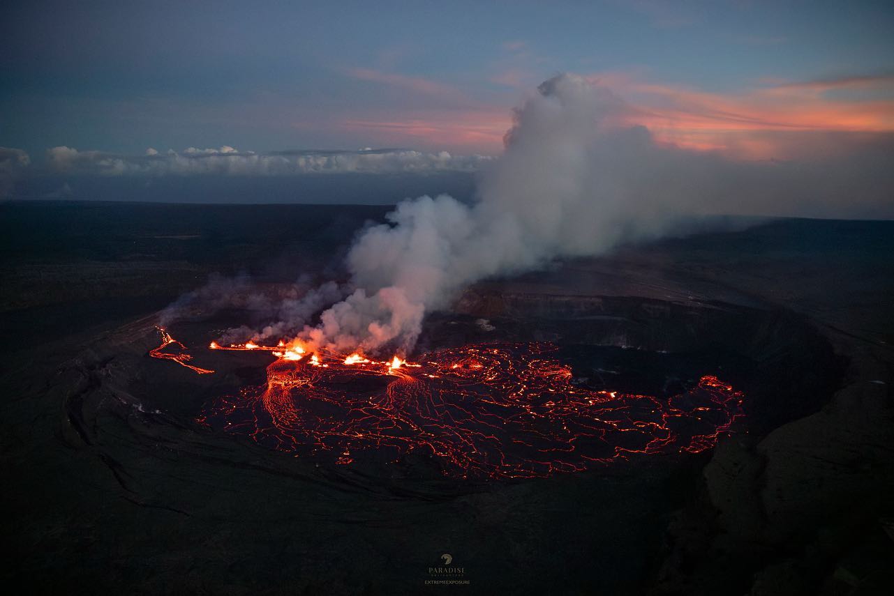
Multiple minor fountains remain active in the eastern portion of Halema‘uma‘u crater floor and on the downdropped block within Kīlauea’s summit caldera. The line of vents stretches approximately 0.8 miles (1.4 km), from the eastern part of Halema‘uma‘u crater floor extending into the east wall of the downdropped block. Effusion rates appear down from initial eruptive rate, but remain high. Lava fountain heights have decreased since the eruption onset, but remain up to about 10-15 meters (32-50 feet) high this morning. Lava erupted from fissures on the downdropped block is flowing in a westward direction towards Halema‘uma‘u crater, covering much of the surface with active lava. The laser rangefinder is aimed at a western portion of Halema‘uma‘u crater, not near the new eruptive activity, and recorded about 2.5 m (8 feet) of new lava added to that portion of the crater floor.
Source : HVO
Photo : Bruce Omori / paradise helicopter
Peru , Ubinas :
Analysis period: September 4 to 10, 2023. Arequipa, September 11, 2023.
Alert level: ORANGE
The Geophysical Institute of Peru (IGP) reports that the eruptive processes of the Ubinas volcano (Moquegua region) maintain moderate levels. During this period, gas emissions were recorded which reached up to 1000 m above the summit of the volcano. For this, it is suggested that the authorities maintain the volcanic alert level at Orange level.
During the analysis period, the occurrence of 183 volcano-tectonic (VT) type earthquakes was detected, associated with rock rupture processes that occur inside the volcano. In addition, 27 long-period (LP) seismic signals were recorded, associated with the movements of volcanic fluids (gas and magma), with a maximum energy of 0.04 Megajoules. During this period, no volcanic explosions or ash emissions were recorded.
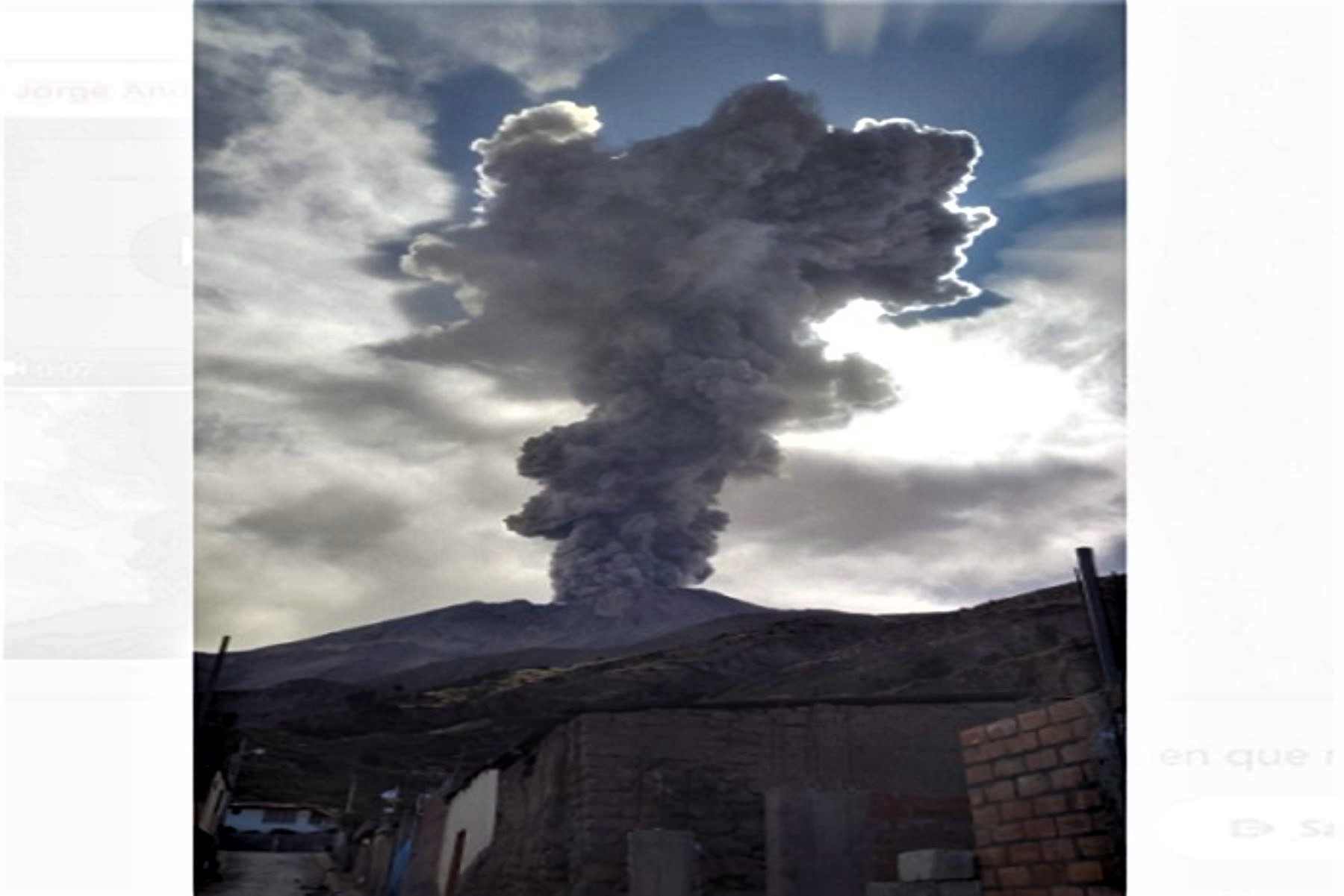
Surveillance cameras made it possible to identify emissions of gas and water vapor which reached heights of 1000 m above the summit of the volcano, which were dispersed mainly towards the South-East, East and North sectors. – East of the Ubinas volcano with a radius of 5 km. On the other hand, monitoring of the deformation of the volcanic structure shows variations of less than 7 mm of displacement (slight tendency towards inflation). Satellite monitoring has not shown thermal anomalies in the Ubinas crater.
RECOMMENDATIONS
• Keep the volcanic alert level at ORANGE level.
Source : Cenvul.
Photo : Andina
Chile , Puyehue – Cordon Caulle :
Seismology
The seismological activity of the period was characterized by the recording of:
527 seismic events of type VT, associated with the fracturing of rocks (Volcano-Tectonics). The most energetic earthquake had a local magnitude (ML) value equal to 3, located 4.7 km to the South-South-West and with a depth of 4.8 km compared to the crater of the 2011 eruption ( for more information, see REAV of August 19).
7 LP type seismic events, associated with fluid dynamics inside the volcanic system (Long Period). The size of the largest earthquake evaluated from the Reduced Displacement (RD) parameter was equal to 7 cm2.
Fluid geochemistry
No anomalies have been reported in the emissions of sulfur dioxide (SO2) into the atmosphere in the area near the volcanic complex, according to data published by the Tropospheric Monitoring Instrument (TROPOMI) and the Ozone Monitoring Instrument (OMI) Sulfur Dioxide Group.
Satellite thermal anomalies
During the period, no thermal alerts were recorded in the area associated with the volcanic complex, according to data processed by the Mid-Infrared Observation of Volcanic Activity (MIROVA). In addition, no radiance anomalies were reported thanks to the analytical processing of Sentinel 2-L2A satellite images, in combination of false color bands.
Geodesy
The geodetic activity of the period was characterized by:
– Medium to high magnitudes of horizontal components, a process historically observed in the complex.
– High magnitudes of vertical components, a process historically observed in the complex.
Surveillance cameras
The images provided by the fixed camera installed near the complex did not record degassing columns or variations linked to surface activity.
Activity remained at levels considered low, suggesting stability of the volcanic system. The technical volcanic alert is maintained in:
GREEN TECHNICAL ALERT: Active volcano with stable behavior – There is no immediate risk.
Source : Sernageomin
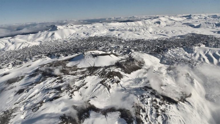
Photo : lmneuquen.
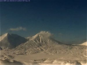
Kamchatka , Sheveluch :
VOLCANO OBSERVATORY NOTICE FOR AVIATION (VONA)
Issued: September 11 , 2023 .
Volcano: Sheveluch (CAVW #300270)
Current aviation colour code: ORANGE
Previous aviation colour code: orange
Source: KVERT
Notice Number: 2023-101
Volcano Location: N 56 deg 38 min E 161 deg 18 min
Area: Kamchatka, Russia
Summit Elevation: 3283 m (10768.24 ft), the dome elevation ~2500 m (8200 ft)
Volcanic Activity Summary:
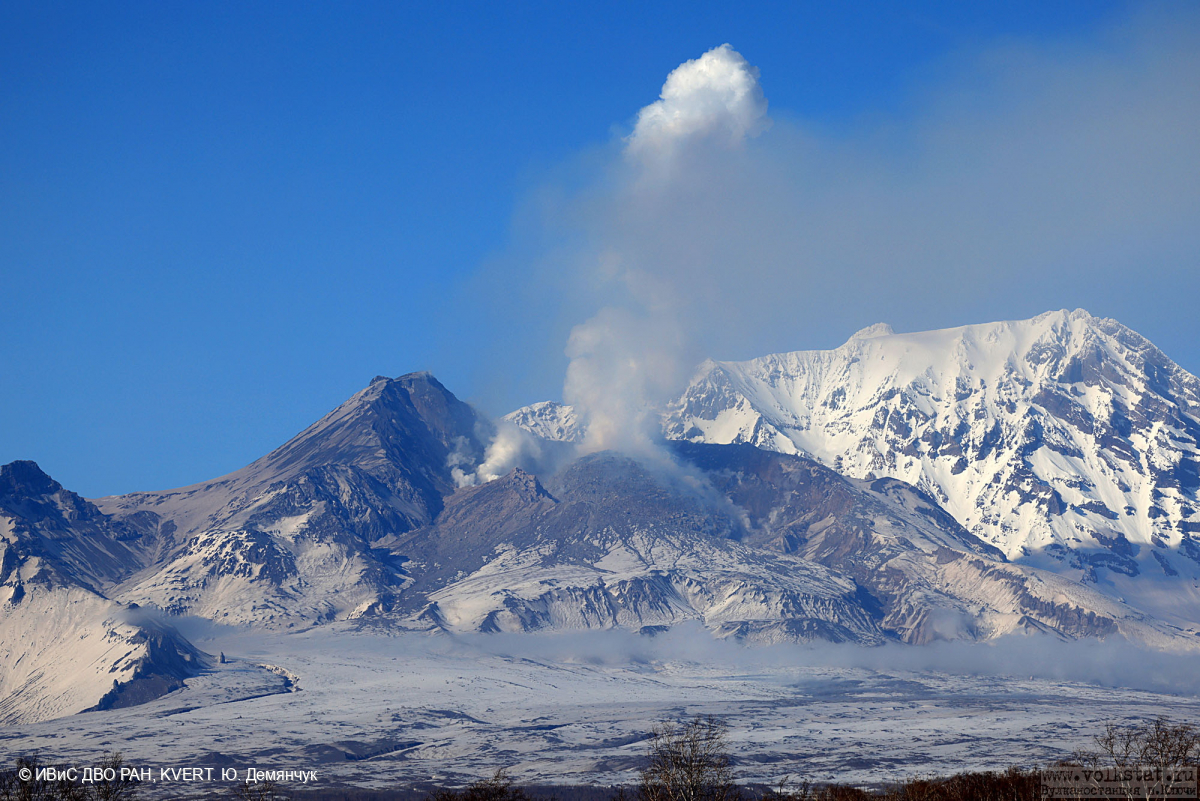
Video and satellite data by KVERT shows a strong wind lifts ash from the southern slopes of Sheveluch volcano, and a plume of resuspended ash is extending about 70 km to the east-south-east of the volcano.
An extrusive-effusive eruption of the volcano continues. A danger of ash explosions up to 10 km (32,800 ft) a.s.l. is remains. Ongoing activity could affect international and low-flying aircraft.
Volcanic cloud height:
2000-2500 m (6560-8200 ft) AMSL Time and method of ash plume/cloud height determination: 20230911/2030Z – Himawari-9 14m15
Other volcanic cloud information:
Distance of ash plume/cloud of the volcano: 70 km (43 mi)
Direction of drift of ash plume/cloud of the volcano: ESE / azimuth 113 deg
Time and method of ash plume/cloud determination: 20230911/2030Z – Himawari-9 14m15
Remarks: Resuspended ash
Source : Kvert
Photo : Yu. Demyanchuk, IVS FEB RAS, KVERT
Alaska , Great Sitkin :
52°4’35 » N 176°6’39 » W,
Summit Elevation 5709 ft (1740 m)
Current Volcano Alert Level: WATCH
Current Aviation Color Code: ORANGE
Slow eruption of lava in the summit crater likely continues. Seismicity remains low with a few earthquakes detected over the past day. Weakly elevated surface temperatures were observed in satellite images. No activity was observed in partly clear web camera images.
The current lava flow at Great Sitkin Volcano began erupting in July 2021. No explosive events have occurred since a single event in May 2021.
Local seismic and infrasound sensors, web cameras, regional infrasound and lightning networks, and satellite data are used to monitor the volcano.
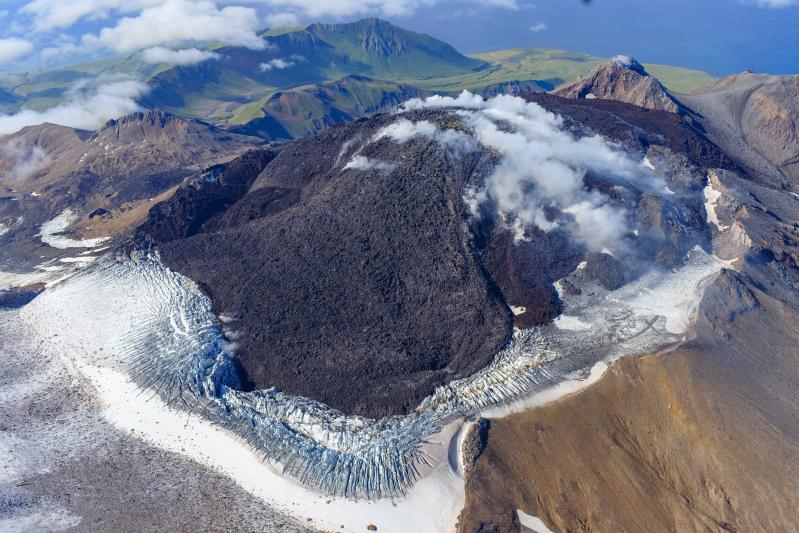
Oblique view of Great Sitkin Volcano looking west at the active lava flows in the crater. Photo taken on September 1, 2023 during a helicopter overflight by AVO geologists. The currently active lobe of the flow field is visible moving into the crater ice field on the lower left side of the image.
Great Sitkin Volcano is a basaltic andesite volcano that occupies most of the northern half of Great Sitkin Island, a member of the Andreanof Islands group in the central Aleutian Islands. It is located 26 miles (43 km) east of the community of Adak. The volcano is a composite structure consisting of an older dissected volcano and a younger parasitic cone with a ~1 mile (1.5 km)-diameter summit crater. A steep-sided lava dome, emplaced during the 1974 eruption, occupies the center of the crater. That eruption produced at least one ash cloud that likely exceeded an altitude of 25,000 ft (7.6 km) above sea level. A poorly documented eruption occurred in 1945, also producing a lava dome that was partially destroyed in the 1974 eruption. Within the past 280 years a large explosive eruption produced pyroclastic flows that partially filled the Glacier Creek valley on the southwest flank.
Source : AVO
Photo : Loewen, Matt / Alaska Volcano Observatory / U.S. Geological Survey.