September 04 , 2023.
Kamchatka , Klyuchevskoy :
VOLCANO OBSERVATORY NOTICE FOR AVIATION (VONA)
Issued: September 04 , 2023
Volcano: Klyuchevskoy (CAVW #300260)
Current aviation colour code: ORANGE
Previous aviation colour code: yellow
Source: KVERT
Notice Number: 2023-93
Volcano Location: N 56 deg 3 min E 160 deg 38 min
Area: Kamchatka, Russia
Summit Elevation: 4750 m (15580 ft)
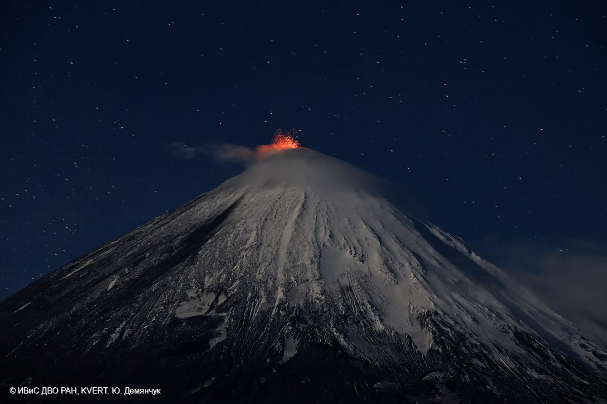
The summit eruption of the Klyuchevskoy volcano continues: Strombolian activity of the crater and the lava flow effuse along the Apakhonchich chute on August 06, 2023.
Volcanic Activity Summary:
Video and satellite data by KVERT shows a strong wind lifts ash from the easthern slopes of Klyuchevskoy volcano, and a plume of resuspended ash is extending about 95 km to the east of the volcano.
The summit explosive eruption of the volcano continues. Ash explosions up to 6 km (19,700 ft) a.s.l. could occur at any time. Ongoing activity could affect low-flying aircraft.
Volcanic cloud height:
3000-3500 m (9840-11480 ft) AMSL Time and method of ash plume/cloud height determination: 20230904/0030Z – Video data
Other volcanic cloud information:
Distance of ash plume/cloud of the volcano: 95 km (59 mi)
Direction of drift of ash plume/cloud of the volcano: E / azimuth 90 deg
Time and method of ash plume/cloud determination: 20230904/0000Z – Himawari-9 14m15
Source : Kvert
Photo : Yu. Demyanchuk, IVS FEB RAS, KVERT
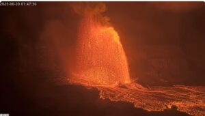
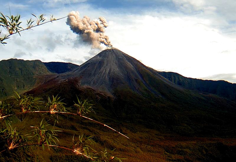
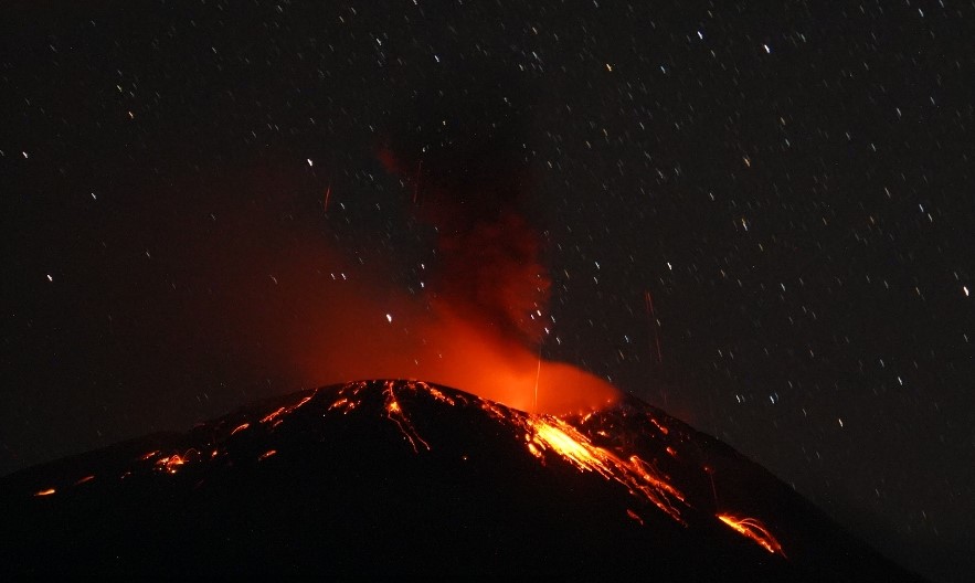
Ecuador , Reventador :
DAILY REPORT ON THE STATE OF THE REVENTADOR VOLCANO, Saturday September 2, 2023.
Information Geophysical Institute – EPN.
Surface activity level: High, Surface trend: No changes
Internal activity level: Moderate, Internal trend: No changes
Seismicity: From September 1, 2023, 11:00 a.m. to September 2, 2023, 11:00 a.m.:
The following table shows the number of seismic events from the reference station in the last 24 hours.
Explosion (EXP) 24
Long Period (LP) 10
Transmitting Tremor (TREMI) 23
Harmonic Tremor (TRARM) 7
Rains / Lahars:
There are no reports of rain. “In the event of heavy rains, these could remobilize the accumulated materials, generating mud and debris flows which would flow down the sides of the volcano and flow into adjacent rivers.”
Emissions/ash column:
Yesterday afternoon and night, several emissions were recorded with heights between 300 and 1000 meters above the level of the crater dispersing towards the West. On the other hand, today early in the morning, several emissions were observed with heights between 500 and 1,000 meters above the level of the crater, in the West direction. Two VONA messages were transmitted, in addition to receiving a report issued thanks to satellite surveillance carried out by Washington-VAAC.
Other monitoring parameters:
The FIRMS satellite system records 1 thermal anomaly in the last 24 hours.
Observation:
Yesterday afternoon, the volcano remained cloudy, while the night was clear, thus recording an incandescence at the level of the crater with the expulsion of material and its descent to 100 meters below the level of the crater. Today morning, the volcano experienced episodes of clarification, for the moment the weather is cloudy.
Alert level: Orange.
Source : IGEPN.
Photo : IGEPN.
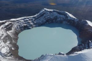
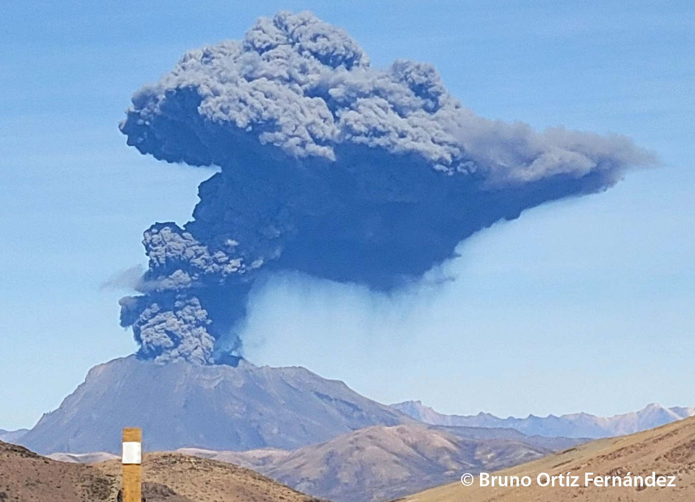
Peru , Ubinas :
o Moderate level eruptive process.
o Over the past 24 hours, ash and gas emissions have been recorded at heights less than 500 m above the summit of the volcano. Likewise, 89 earthquakes associated with rock fracturing processes inside the volcano, 108 seismic signals related to the movement of fluids and gases, as well as 36 accumulated minutes of seismic signals related to ash and gas emissions have been detected.
o According to the analysis of satellite images and the SENAMHI dispersion model, the dispersion of ashes and gases took place towards the East and South-East sectors, towards the district of Ubinas and its agglomerations in the said sectors .
o The approximate impact radius due to ashfall after today’s emissions is less than 5 km from the crater, i.e. within the range of the volcano.
o Satellite systems did not detect thermal anomalies on the crater surface.
o Monitoring of deformation on the volcanic structure shows variations of less than 7 mm of displacement (slight tendency towards inflation).
Conclusion:
The Ubinas volcano has developed an eruptive process of moderate levels, characterized by the recording of significant internal seismic activity and ash emissions. Over the past 24 hours, emissions of ash and gas less than 500 m above the summit of the volcano have been recorded. The population must remain vigilant in the face of possible ash falls and follow the recommendations made by the Civil Protection authorities.
Recommendation:
Stay attentive to volcanological reports and bulletins issued by the IGP through CENVUL.
Current volcano alert level: orange
Source : Cenvul.
Photo : Bruno Ortiz Fernandez.
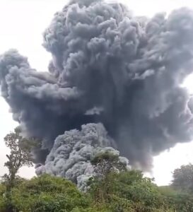
Indonésie , Ili Lewotolok :
An eruption of Mount Ili Lewotolok occurred on Sunday, September 3, 2023, at 7:23 p.m. WITA. No visual rash was observed. This eruption was recorded on a seismograph with a maximum amplitude of 33.2 mm and a duration of 52 seconds.
VOLCANO OBSERVATORY NOTICE FOR AVIATION – VONA
Issued : September 3 , 2023
Volcano : Ili Lewotolok (264230)
Current Aviation Colour Code : ORANGE
Previous Aviation Colour Code : orange
Source : Ili Lewotolok Volcano Observatory
Notice Number : 2023LEW052
Volcano Location : S 08 deg 16 min 19 sec E 123 deg 30 min 18 sec
Area : East Nusa Tenggara, Indonesia
Summit Elevation : 4554 FT (1423 M)
Volcanic Activity Summary :
Eruption at 11h23 UTC (19h23 local).
Volcanic Cloud Height :
Ash-cloud is not observed.
Other Volcanic Cloud Information :
Ash-cloud is not observed.
Remarks :
Eruption recorded on seismogram with maximum amplitude 33.2 mm and maximum duration 52 second.
Source et photo : Magma Indonésie.
Guatemala , Santiaguito :
Weather conditions: clear weather
Wind: North-East
Precipitation: 15.0 mm.
Activity:
The Santa María-Santiaguito Volcanic Complex Observatory reports cloudy conditions at dawn that make observing activity difficult; at night, incandescence was observed in the dome of the Caliente dome. Small to moderate explosions occur at a rate of 1 to 2 per hour and raise columns of water vapor and ash to heights between 500 and 1,000 meters above the dome and send down flows of blocks and of ashes towards the South-West and the South – South-East flanks of the Caliente dome, leaving its ravines filled with gray ashes, which reach the base of the dome. The accumulation of material from these flows causes the continued thickening of the lava flow promontory in the Zanjón Seco and San Isidro channels.
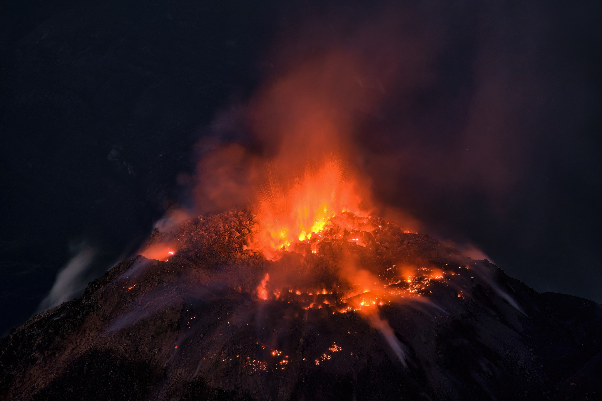
The descent of these flows produces faint noises perceptible in areas close to the domes. Detachment of boulders from the dome and occasional lava flows continue. The southwest wind can cause ash falls on San Marcos Palajunoj and Loma Linda. It is recommended not to approach the lava flow in the Zanjón Seco and San Isidro channels, due to the intense heat it emits and the collapses that still occur on its edges, which could cause burns and other serious injuries to those who come near it. Activity remains at a high level and continues to accumulate material in an unstable manner in the dome of the Caliente dome, as well as along the lava flow, so there remains the possibility that with explosions or under the effect of gravity, part of this material collapses and long-distance pyroclastic flows are generated towards the South-West, South and East.
Source: Insivumeh
Photo : Thomas Spinner via FB .