October 31 , 2022.
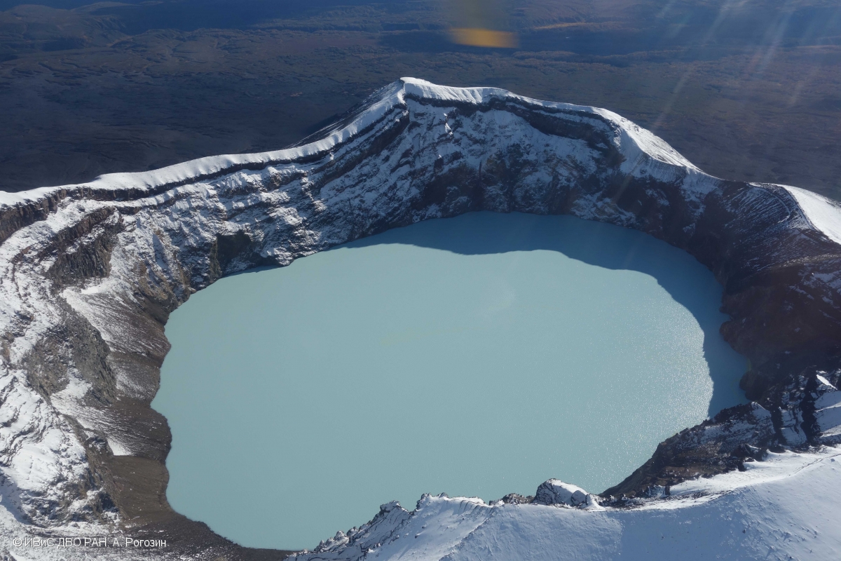
Kamchatka , Mali Semyachik :
VOLCANO OBSERVATORY NOTICE FOR AVIATION (VONA)
Issued: October 28 , 2022
Volcano: Maly Semyachik (CAVW #300140)
Current aviation colour code: ORANGE
Previous aviation colour code: green
Source: KVERT
Notice Number: 2022-152
Volcano Location: N 54 deg 8 min E 159 deg 40 min
Area: Kamchatka, Russia
Summit Elevation: 1560 m (5116.8 ft)
Volcanic Activity Summary:
A strong wind lifted ash from the southern slopes of Maly Semyachik volcano on 27-28 October, 2022. Satellite data by KVERT shows a plume of resuspended ash is extending for 123 km to the southeast of the volcano. Maly Semyachik volcano is quiet, it has no eruption at now.
Maly Semyachik volcano is quiet. The volcano has no eruption at now.
Volcanic cloud height:
2500 m (8200 ft) AMSL Time and method of ash plume/cloud height determination: 20221028/0230Z – Himawari-8 14m15
Other volcanic cloud information:
Distance of ash plume/cloud of the volcano: 123 km (76 mi)
Direction of drift of ash plume/cloud of the volcano: SE / azimuth 129 deg
Time and method of ash plume/cloud determination: 20221028/0230Z – Himawari-8 14m15
Source : Kvert.
Photo : A. Rogozin, IVS FEB RAS
Indonesia , Ibu :
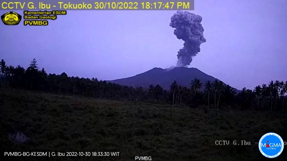
Mount Ibu erupted on Sunday, October 30, 2022 at 6:20 p.m. WIT with an ash column height observed at ± 2000 m above the summit (± 3325 m above sea level). The ash column was observed to be gray with a thick intensity, oriented towards the West. This eruption was recorded on a seismograph with a maximum amplitude of 30 mm and a duration of 112 seconds.
Recommendation
Communities around Mount Ibu and visitors/tourists should not travel within a radius of 2.0 km, with a sectoral expansion of 3.5 km towards the crater opening in the northern part of the active crater of Mount Ibu .
In the event of ash rain, people who are active outside the home are advised to use nose, mouth (mask) and eye (goggles) protection.
Source et photo : Magma Indonésie.
Chile , Hudson :
Special Report on Volcanic Activity (REAV), Aysen Del General Carlos Ibanez Del Campo area, Hudson volcano, October 31, 2022, 2:58 a.m. local time (mainland Chile).
The National Service of Geology and Mines of Chile (Sernageomin) publishes the following PRELIMINARY information, obtained through the monitoring equipment of the National Volcanic Monitoring Network (RNVV), processed and analyzed at the Volcanological Observatory of the Southern Andes ( Ovdas):
On Monday October 31, 2022, at 02:23 local time (05:23 UTC), the monitoring stations installed near the Hudson volcano recorded an earthquake associated with both rock fracturing (volcano-tectonic type) and fluid dynamics in the volcanic system (hybrid type).
The characteristics of earthquakes after their analysis are as follows:
ORIGINAL TIME: 02:23 local time (05:23 UTC)
LATITUDE: 45.879°S
LONGITUDE: 72.978°W
DEPTH: 1.4 km
REDUCED DISPLACEMENT: 3934 cm2
COMMENTS:
At the time of issuing this report, 25 other seismic events of similar characteristics but of lower energy have been recorded. In the context of this seismic episode, which began at 02:01 (05:01 UTC) it is noted that the recorded seismicity corresponds mainly to volcano-tectonic earthquakes. However, a large number of recorded events are characterized by the dominance of low frequencies, around 1.6 Hz.
The volcanic technical alert remains at the Green level.
Sources : Sernageomin.
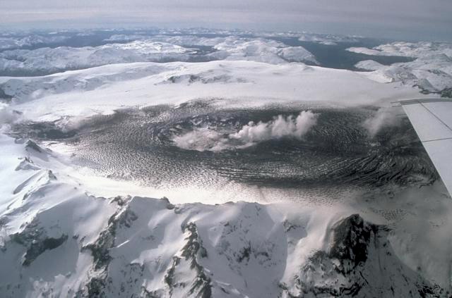
Photo : Norm Banks.
Ecuador , Cotopaxi :
Special Volcanic Bulletin, Cotopaxi Volcano–2022-N° 001
Increase in surface and internal activity of the Cotopaxi volcano, October 28, 2022
On October 21 at 7:44 p.m., seismic stations on the flanks of Cotopaxi began recording a long-duration, low-amplitude low-frequency tremor-type seismic signal. This signal was maintained until 00:40 on Saturday October 22 and was accompanied by an emission of gas and ash, producing a moderate fall of this material towards the José Rivas Refuge. The volcanic column was detected by the Washington Volcanic Ash Advisory Center (W-VAAC), indicating a northeasterly direction of the ash cloud. Since this event, a continuous emission of gas has been observed from the crater of the volcano reaching a variable height between 200 and 1000 m above its level. This volcanic reactivation did not show any precursor signs in the medium term. For the moment, the monitoring parameters analyzed (seismicity, gas and ash) indicate a magmatic contribution to this reactivation.
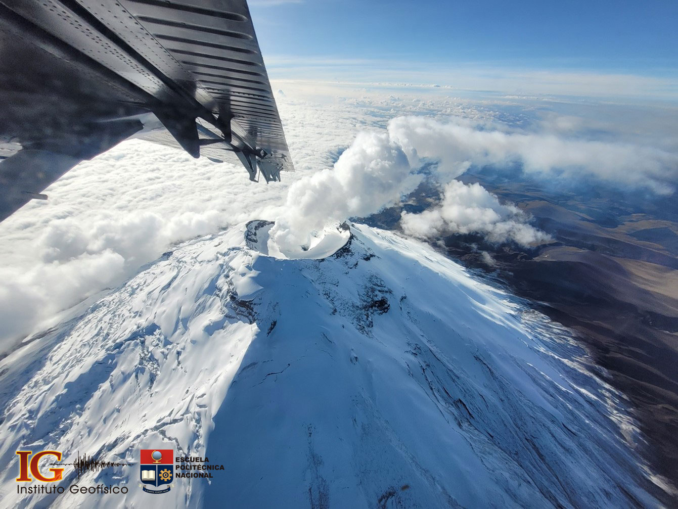
Gas emission from the Cotopaxi volcano taken during the overflight provided by the Armed Forces, October 27, 2022 (Photo: S. Hidalgo)
Although the surface activity of October 21 is the highest recorded in the last seven years, it is very low compared to what was observed between August and November 2015. The uncertainty on the evolution of this activity is very great because of the absence of clear premonitory signals of these events. In this sense, it is important to keep the monitoring system active and to continue the prevention and mitigation tasks related to the eruptive scenarios of the Cotopaxi volcano. The IGEPN remains attentive to the changes in the conditions presented by the volcano to give, as far as possible, timely information to the authorities and the population in general.
Technical-scientific appendix / Seismic recording:
On Friday, October 21, around 7:44 p.m. local time, an episode of volcanic tremor was recorded by the local seismic monitoring network, in particular in the seismic station BREF, located 2.4 km north of the summit of the volcano. The sequence begins at 7:44 p.m. with a high frequency event of magnitude 0.7 (Fig. 1, black arrow). A few minutes later, the episode of volcanic tremor begins. The most intense phase of the tremor lasted about 4 hours. The amplitude of the tremor is characterized as weak. For comparison, the October 21, 2022 tremor barely exceeded half the amplitudes of the tremor episodes recorded during the 2015 eruptive process. In addition, the October 21 tremor constituted a single 4-hour pulse, whereas in 2015 these episodes lasted several days. This means that the October 21 quake was energetically weak compared to other episodes in the past.
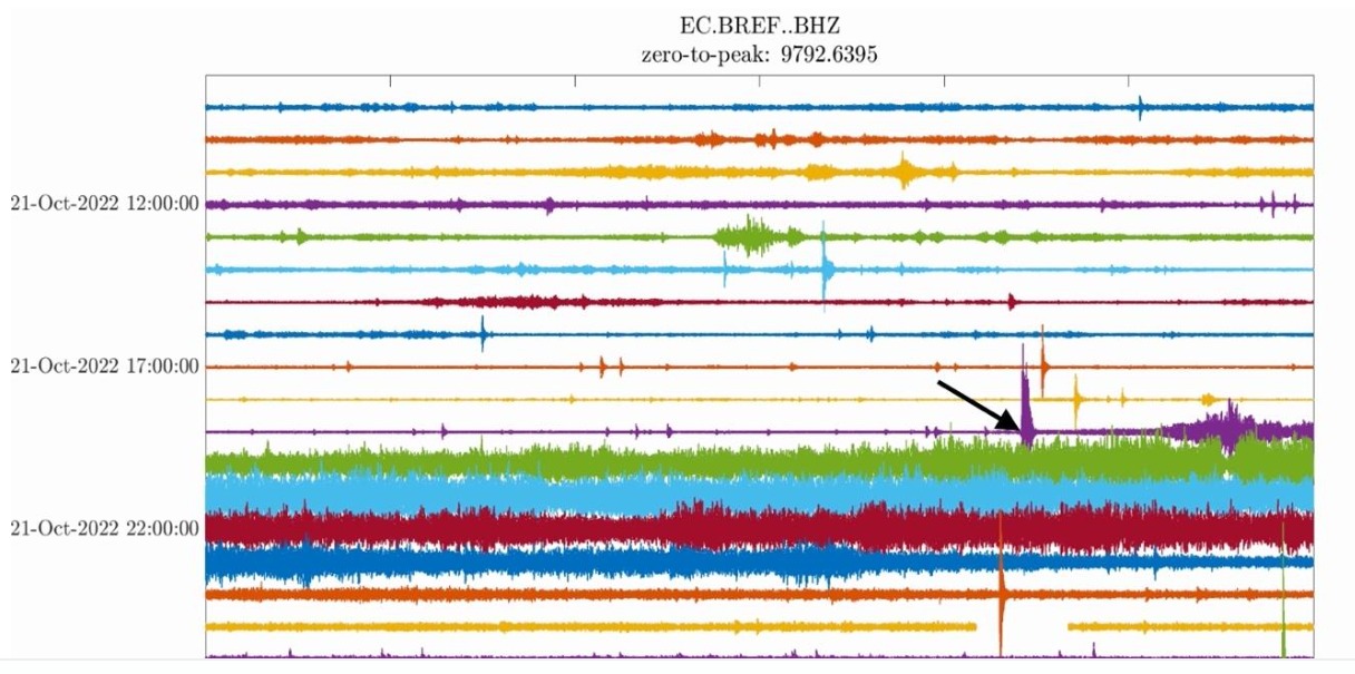
Figure 1. Seismic plot of the BREF station, located near the José Ribas Refuge on the northern flank of the Cotopaxi volcano. Each line corresponds to one hour of data in local time. Starting at 7:44 p.m. (black arrow), an event is noted that seems to trigger the tremor episode. The data is filtered between 0.5 and 16 Hz to highlight the episode of volcanic tremor that night.
Thanks to aerial thermal monitoring, it was possible to verify that the fumarolic fields located outside the crater are active and present temperatures similar to those of previous years (post 2015), with maximum values of 40°C. On the other hand, the duct presents thermal anomalies both in its walls and in its base, from which the real temperature cannot be estimated due to the large quantity of gas emitted continuously.
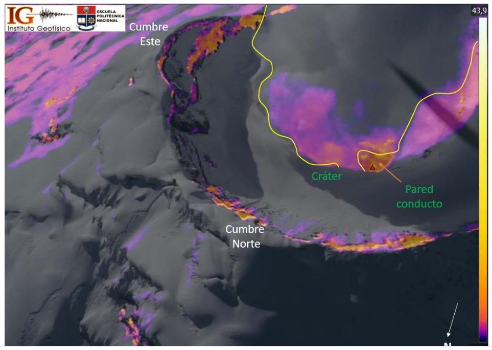
Thermo-visual aerial image of the Cotopaxi volcano crater from the northwest. The thermal anomalies corresponding to this zone are observed, in particular the emission of gas and the wall of the duct.
Data interpretation
Based on the information available, it is concluded that the Cotopaxi volcano presented very little eruptive activity with a volcanic explosivity index (VEI) of less than 1. The joint analysis of the various monitoring data shows that the activity Recent Cotopaxi is caused by the presence of magma in the volcanic conduit, which interacts with the hydrothermal system of the volcano. However, so far there is no evidence of a larger volume of magma entering the system. Monitoring data obtained from October 21 to 28 indicate a gradual decrease in surface activity characterized mainly by columns of gas and water vapor reaching up to 1000 m above the crater. For the moment, the internal activity does not show any significant change. Seismicity continues to be dominated by small LP-type earthquakes; there is no detectable deformation on the flanks and magmatic gases, although present, are at moderate levels. There is no evidence yet of a significant change in the behavior of the Cotopaxi volcano.
Source : IGEPN
Read the full article : https://informes.igepn.edu.ec/igepn-registro-web/pages/public/InformeGenerado.jsf?directorio=28452&fbclid=IwAR0I0E-wVAhP6D9zIlJdmOlPtVqfm8gHjp3jz0LlAIQssH3q-mDMM3FbBHk
Photos : IGEPN , S. Hidalgo.
Hawaii , Mauna Loa :
19°28’30 » N 155°36’29 » W,
Summit Elevation 13681 ft (4170 m)
Current Volcano Alert Level: ADVISORY
Current Aviation Color Code: YELLOW
Activity Summary:
Mauna Loa is not erupting and there are no signs of an imminent eruption at this time. However, Mauna Loa continues to be in a state of heightened unrest as indicated by increased earthquake activity and inflation of the summit. The current unrest is most likely being driven by renewed input of magma 2–5 miles (3–8 km) beneath Mauna Loa’s summit. Monitoring data show no significant changes in the past day.
Observations:
During the past 24 hours, HVO detected 27 small-magnitude (below M3.0) earthquakes 2–3 miles (2–5 km) below Mokuʻāweoweo caldera and 4–5 miles (6–8 km) beneath the upper-elevation northwest flank of Mauna Loa. Both of these regions have historically been seismically active during periods of unrest on Mauna Loa.
Global Positioning System (GPS) instruments at the summit and on the flanks of Mauna Loa continue to measure inflation at rates elevated since mid-September. However, tiltmeters at the summit are not showing significant surface deformation over the past week.
Concentrations of sulfur dioxide (SO2), hydrogen sulfide (H2S), and carbon dioxide (CO2), as well as fumarole temperatures, remain stable at the summit and at Sulphur Cone on the upper Southwest Rift Zone. Webcam and thermal camera views have shown no changes to the volcanic landscape on Mauna Loa over the past week.
Source : HVO.
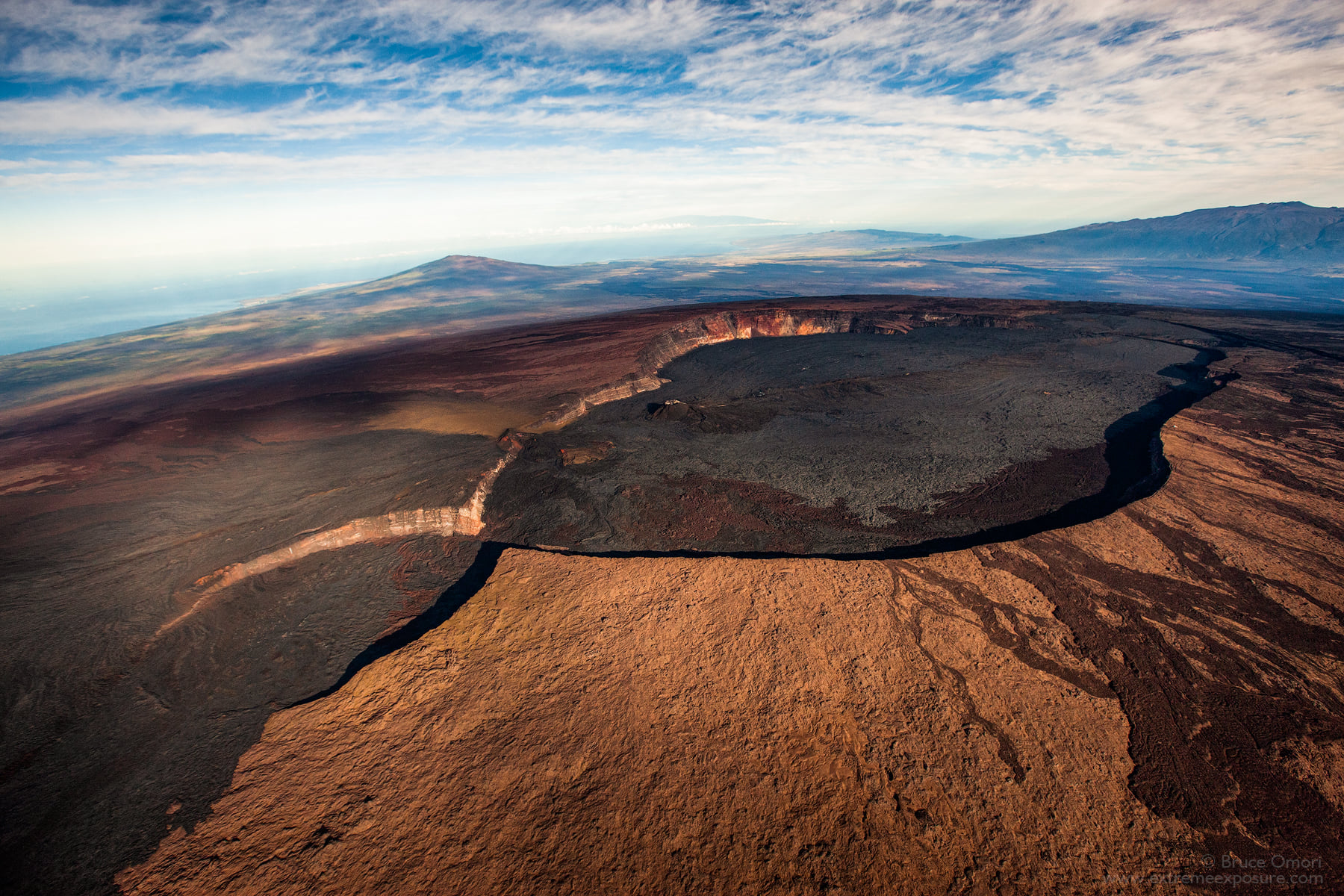
Photo : Bruce Omori .