July 25 , 2023.
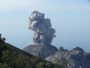
Iceland , Litli Hrútur :
The Litli-Hrútur crater wall has already collapsed, but it could happen again in the newly formed crater, says volcanologist Þorvaldur Þórðarsson. If it collapses this time, it could turn into a major accident if the area under the crater had not been cleared beforehand. Þorvaldur also believes that a new fissure on Mount Keilir is possible, reports Vísir.
13 days ago, the land on the Litli-Hrútur mountain opened up. now it looks like the crater is filled to the brim with lava like a pot. According to volcanologist Þorvaldur Þórðarsson, the crater has also become so large that the walls can collapse in a very short time.
Crater collapse can cost lives
« If that happens, we don’t know which way it will collapse. It could go west, like last time, but also east. There are people standing very close to the crater and they are in a very dangerous place there. When it goes east, it’s not certain that people will escape the lava flow because it flows so fast that it can travel 100 meters in two seconds, » says Þorval hard.
Even if the crater collapses again, it should not necessarily be expected that the lava will reach the coastal road of Suðurstrandavegur earlier than expected. This isn’t expected until mid-August or early September at the earliest – if the eruption doesn’t just stop sooner.
It is impossible to predict how long this will last, it could be six days, six months or years. Past examples show similar volcanic eruptions lasting even over 100 years.
He also considers that a new fissure to the east of Mount Keilir is entirely possible, as magma is accumulating there. Increased geothermal activity was also seen there, which is consistent with the fact that the magma came quite close to the earth’s surface.
Closing from 6 p.m. due to unreasonable tourists
The potential danger of a crater collapse coupled with tourists ignoring instructions from on-site emergency services means the eruption site is now only open until 6 p.m. After that, access from Suðurstrandavegur and Vigdísarvellir will be closed.
Last night, a group of about 60 foreign volcano enthusiasts gathered on a ridge that was in the middle of two lava flows. There was an acute danger that these two lava flows would unite, and then people would have been trapped. The tourists could only be persuaded to leave their scenic spot after a massive intervention by police and rescue workers.
The night access block is intended to relieve the volunteer rescuers, who previously worked 24 hours a day on the site.
As is often the case, Suðurnes Police regret that it was a small group of people who ruined things for everyone.
Source : Iceland rewiew.
Photo : Maria Ajala.
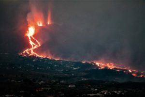
La Réunion , Piton de la fournaise :
Press release from the Paris Institute of Earth Physics, Volcanological Observatory of Piton de la Fournaise, July 24, 2023 – 11:30 a.m. – 07:30 UTC
Ongoing eruption
The eruption which began on July 02, 2023, around 08:30 local time continues. The amplitude of the volcanic tremor (indicator of an emission of lava and gas on the surface) remains very low compared to the beginning of the eruption.
The variations in amplitude of the seismic signals recorded yesterday morning (between 9:30 a.m. and 11 a.m. local time) on the OVPF stations located north of the Enclos which raised suspicion of a resumption of eruptive activity or degassing between 9:30 a.m. and 11 a.m. local time, on the first cracks opened on July 2, 2023, have disappeared. These unusual seismic signals recorded yesterday morning before 11:00 a.m. (local time), having ceased, the suspicion of resumption of activity in the northern part of the Enclos has also disappeared.
Despite a temporary improvement in meteorological conditions at the eruptive site, no estimate of lava flows by satellite method could be made. However, a visual feedback from the Piton de Bert camera was possible at the end of the night, confirming the continuation of the eruption and a still present degassing.
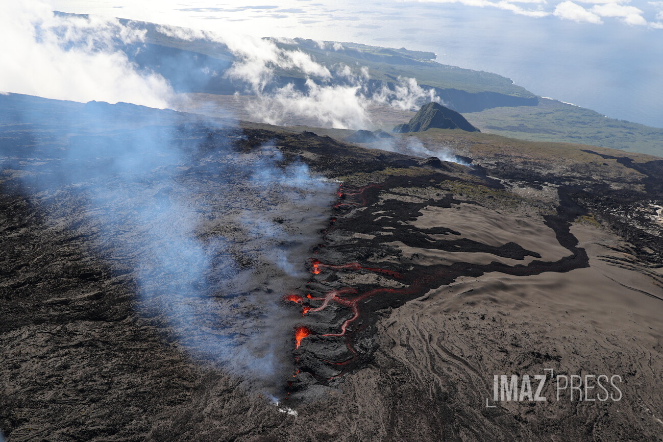
The flow front has not changed since July 5 and is now frozen. It is still 1.8 km from the road.
Low inflation of the massif continues, indicating a re-pressurization of the volcano’s feeding system with possible transfer of deep magma to the latter.
The seismic activity recorded under the summit zone remains weak. Thus over the last 24 hours, no superficial volcano-tectonic earthquake has been recorded. This low seismic activity leads to a reduction in the risk of the appearance of a new crack and/or collapse in the crater, but does not mean that it can be excluded, as shown by the recurrent amplitude variations in the tremor as well as the continuation of the summit inflation.
Alert level: Alert 2-1 (eruption in the Enclos without any particular threat to the safety of people, property or the environment).
Source : OVPF
Photo : Imaz Press
Pérou , Ubinas :
Analysis period: 03-04 July 2023 Arequipa, 05 July 2023.
Alert level: ORANGE
The Geophysical Institute of Peru (IGP) reports that the geophysical processes which allow to know the dynamic behavior of the Ubinas volcano (Moquegua region) present moderate levels, characterized by volcanic explosions and ash emissions which reached up to 4500 m above the summit of the volcano. For this, it is suggested to the authorities to maintain the volcanic alert level at the Orange level.
During the analysis period, the occurrence of 46 volcano-tectonic (VT) type earthquakes was detected, associated with rock breaking processes that occur inside the volcano. In addition, 122 seismic signals of long period type (LP) were recorded, associated with the movements of volcanic fluids (gas and magma), with a maximum energy of 4.8 Megajoules and 7 seismic signals associated with significant explosive activity. Finally, it has been identified a duration of 9 hours / day of seismic recordings in relation to ash emissions with a maximum of 14 hours, recorded on July 17 and 22.
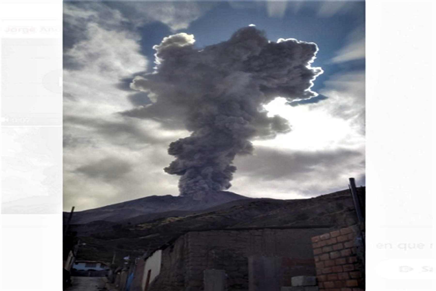
The monitoring of the deformation of the volcanic structure, show variations of less than 7 mm of displacement (slight tendency to inflation). Satellite monitoring did not show any thermal anomalies in the Ubinas crater. Surveillance cameras identified volcanic explosions and columns of gas and ash that reached heights of 4500 m above the summit of the volcano, which were dispersed mainly to the South, South-East, East, North-East, North-West, West and South-West sectors of the Ubinas volcano with a radius of 40 km (districts of Ubinas, Matalaque, Lloque, Coalaque, Lloque, Chojata , Yunga and San Juan de Tarucani).
RECOMMENDATIONS
• Raise the Volcanic Alert Level to ORANGE.
Source : Cenvul
Photo : Andina
Philippines , Mayon :
MAYON VOLCANO BULLETIN 25 July 2023 8:00 AM
In the past 24-hour period, slow effusion of lava from the summit crater of Mayon Volcano continued to feed and bulk up established lava flows on the Mi-isi (south), Basud (eastern), and Bonga (southeastern) gullies. The two former lava flows have maintained distal lengths of approximately 2.8 kilometers and 600 meters from the crater, while the Bonga lava flow advanced to approximately 2.8 kilometers. Rockfall and pyroclastic density currents or PDCs generated by collapses of the lava flow margins as well as of the summit dome deposited debris still within four (4) kilometers of the crater.
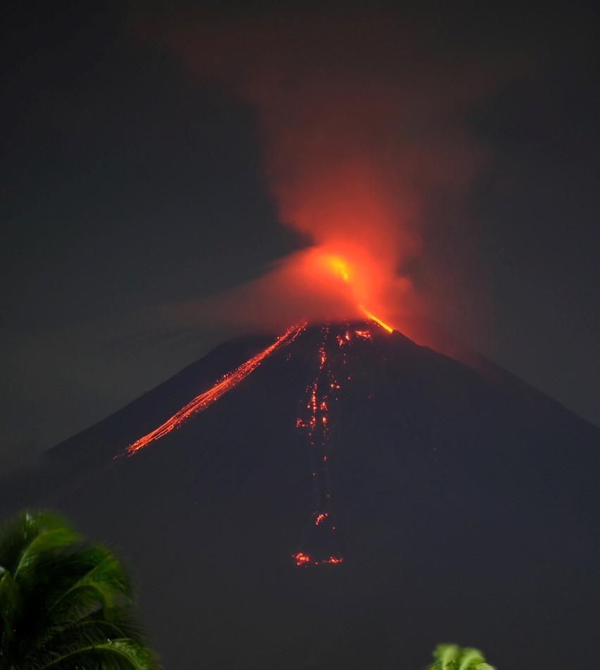
In total, thirty-two (32) LFVQs, four (4) PDCs, and one hundred thirty-eight (138) rockfall events were recorded by the Mayon Volcano Network. Volcanic sulfur dioxide (SO2) emission averaged 3,135 tonnes/day yesterday, 24 July 2023. Short-term observations from electronic tilt and GPS monitoring indicate a deflation of the eastern lower flanks in early July 2023 and inflation of the northwest middle flanks in the third week of July 2023. Longer-term ground deformation parameters from EDM, precise leveling, continuous GPS, and electronic tilt monitoring indicate that Mayon is still generally inflated relative to baseline levels.
Alert Level 3 is maintained over Mayon Volcano, which means that it is currently in a relatively high level of unrest and hazardous eruption within weeks or even days could still be possible.
Source : Phivolcs.
Photo : Dex Baldon
Chile , Parinacota :
Special Report on Volcanic Activity (REAV), Arica and Parinacota region, Parinacota volcano, July 24, 2023, 8:00 p.m. local time (mainland Chile).
The National Service of Geology and Mines of Chile (Sernageomin) publishes the following PRELIMINARY information, obtained through the monitoring equipment of the National Volcanic Monitoring Network (RNVV), processed and analyzed at the Volcanological Observatory of the Southern Andes (Ovdas):
On Monday July 24, 2023, at 6:05 p.m. local time (22:05 UTC), the monitoring stations installed near the Parinacota volcano recorded a swarm of earthquakes associated with volcano-tectonic activity. At the time of issuing this report, there are approximately 120 events, including the highest energy event located 1.1 km north-northeast of the crater.
![]()
The characteristics of earthquakes after their analysis are as follows:
ORIGINAL TIME: 6:43 p.m. local time (22:43 UTC)
LATITUDE: 18.070°S
LONGITUDE: 69.126°E
DEPTH: 11.3 km
LOCAL MAGNITUDE: 1.4 (ML)
COMMENTS:
During the issuance of this report, volcano-tectonic seismicity continues to be recorded, with low magnitude events (ML<1.0).
The volcanic technical alert remains at the Green level.
Source : Sernageomin
Photo : Alvaro Amigo / Sernageomin.