October 03 , 2021.
Spain / La Palma , Cumbre Vieja :
02 October 2021 10:00 UTC, Eruptive activity continues on La Palma.
Since the last declaration, a total of 21 earthquakes have been located in the vicinity of the Cumbre Vieja volcano, two of which were felt by the population. The maximum recorded magnitude is 3.6 (mbLg) corresponding to the earthquake felt with a maximum intensity III-IV in the epicentral zone at 14:13 UTC yesterday. Most of the earthquakes are located between 10-14 km deep in the area where the swarm started on September 1.
Two earthquakes were also located at depths of around 30 km and one shallow earthquake in the area near the eruptive mouth.
The volcanic tremor signal maintains its stable level at levels similar to those of the previous days in a range of average values compared to the values observed since the start of the eruption.
The height of the column measured at 7:30 am today (02/10/2021) is 4500m, a value slightly lower than the previous day.
The island’s network of permanent GNSS stations is showing a return to strain stability.
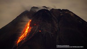
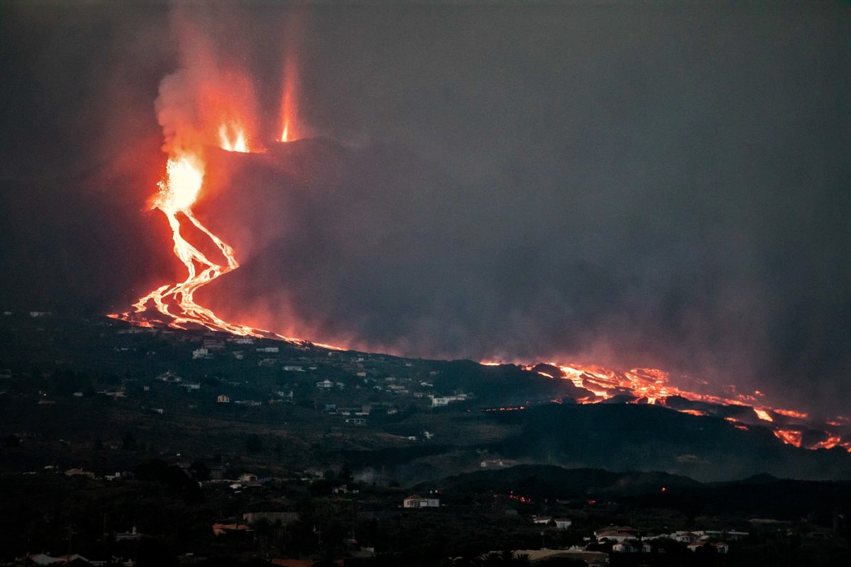
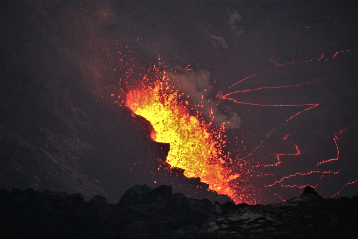
“The fissure eruption continues to show a Strombolian mechanism, with simultaneous explosive and effusive phases. The new flow is flowing west, parallel to that reaching the sea, after reaching the LP212 road this morning. In addition, there are three active centers inside the main crater and two located in the northwest sector of the cone. The volume of material emitted, until the morning of September 30 (cone + casting), is estimated at 80 ± 24 M3.
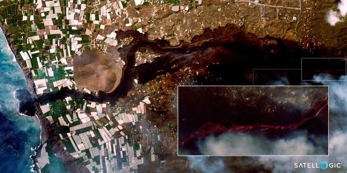
The lava delta front is over 475m from the coast, reaching a depth of 30m. The area covered by the lava delta reached the value of 27.7 ha this morning. The sea plume continues along the edge of the delta, producing clouds of water vapor and other potentially toxic gases, which are concentrated in a small area around the contact.
The fumarolic field extended on the north-north-west flank remains active. The eruptive process may show episodes of increasing and decreasing strombolian activity, as well as pulses with phreato-magmatic activity. The morphology of the cone has changed several times by the successive processes of growth and reconfiguration.
The height measured today of the column of ash and gas is 6000 m.
The seismicity continues to be localized mainly near the seismicity of the first days, at depths between 10 and 15 km. During the last 24 hours, a few dozen earthquakes have been located, the largest of 3.5 mbLg, felt with intensity III-IV EMS. Some surface earthquakes are also recorded in the environment of the eruptive center. Since 3 hours today, the level of the tremor has increased. In some seismic stations near the lava delta, a high frequency tremor is recorded. The deformations show, in stations far from the eruptive center, a slight downward trend in the vertical component. The neighboring stations show impulses possibly related to the eruptive dynamics.
The estimate of the emission rate of sulfur dioxide (SO2) into the atmosphere continues to register relatively high values and consistent with the eruption process, reaching values of 8,700 tonnes per day. In the volcanic plume, the relationship between carbon dioxide and sulfur dioxide (CO2 / SO2) shows that the origin of the gas comes from a deep magmatic system, rich in volatiles, which is compatible with geophysical observations.
No elevated hydrogen sulfide (SH2) value was observed at either measuring station.
The sea plume generated by the lava meeting the sea should not be underestimated, but it should not raise alarms either. It is suggested to pay close attention to the wind forecast for monitoring possible changes in direction of the plume and to act accordingly. Emergency services working within a mile of the delta should wear goggles and gas masks. Washing the eyes after any exposure is also recommended, as symptoms are often not seen until later.
Sources : El Pais , Pevolca.
Photos : Satellogic NewSat-13 via Sherine France , EP / cronicabalear.es.
United – States , Yellowstone :
44°25’48 » N 110°40’12 » W,
Summit Elevation 9203 ft (2805 m)
Current Volcano Alert Level: NORMAL
Current Aviation Color Code: GREEN
Recent work and news
Yellowstone Volcano Observatory scientists are gearing up for some of the last field work of the 2021 season. In the coming weeks, geophysicists will be conducting maintenance on the Norris temperature network to ensure that it remains operational throughout the winter, and also conducting a gravity survey, done every year to help detect changes in mass beneath the ground. They will also be recovering the 17 sites of the semipermanent GPS network—a set of temporary sites that supplement the continuous GPS network during summer months. These stations are deployed every May, after much of the snow melts, and are collected every October, before winter sets in. The GPS receivers are not connected to any radio telemetry, so they must be recovered to download and examine the data. The sites will be redeployed in May 2022.
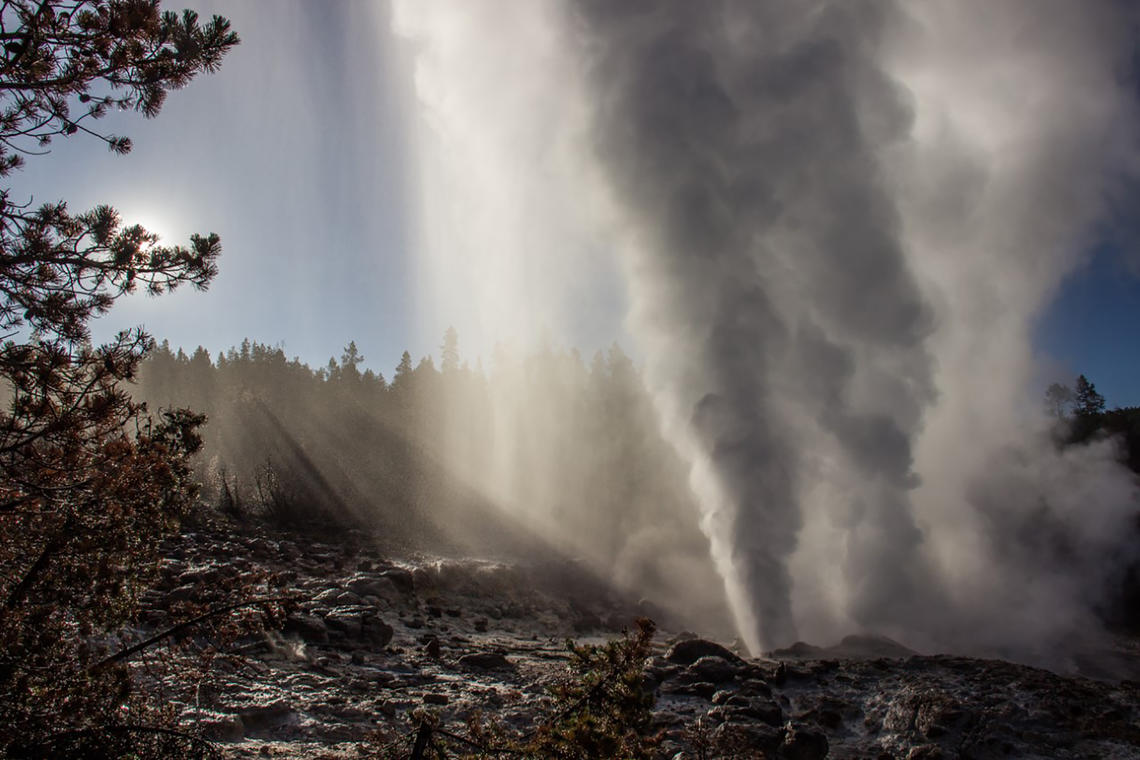
Steamboat Geyser erupts in the golden light of sunrise on July 18th, 2019. The water-dominated part of a Steamboat eruption usually lasts anywhere from 3 to 90 minutes. Afterwards, a steam-dominated phase continues for many hours.
After taking a month off, Steamboat Geyser erupted twice in September—on September 11 and 28—bringing the total number of eruptions for the year to 15. Eruptions are irregular and much less frequent than during the previous three summers, which may indicate that the geyser is trending toward a period of quiescence. This is typical behavior for Steamboat, with the geyser experiencing few-year periods of frequent eruptions separated by years to decades of very few eruptions.
Seismicity
During September 2021, the University of Utah Seismograph Stations, responsible for the operation and analysis of the Yellowstone Seismic Network, located 283 earthquakes in the Yellowstone National Park region. The largest event of the past month was a minor earthquake of magnitude 3.2 located 15.6 miles south of Old Faithful, Yellowstone National Park, on September 8 at 11:01 AM MDT.
September seismicity in Yellowstone was marked by 4 earthquake swarms.
1) A series of 153 earthquakes ~14 miles north-northeast of Old Faithful began September 16 and continued to the end of the month. The largest event (magnitude 1.8) occurred on September 22 at 06:53 PM MDT.
2) A small swarm of 17 earthquakes ~8 miles north-northeast of West Yellowstone, MT, began September 28 and continued to the end of the month. The largest event (magnitude 1.5) occurred September 29 at 07:42 MDT.
3) A small swarm of 16 earthquakes began September 29 and continued to the end of the month beneath Yellowstone Lake ~0.5 miles southwest of Dot Island. The largest event (magnitude 1.9) occurred September 30 at 00:05 AM MDT.
4) A small swarm of 14 earthquakes occurred September 8, located ~15.5 miles south of Old Faithful. The swarm included the largest event of the month (magnitude 3.2; detailed above).
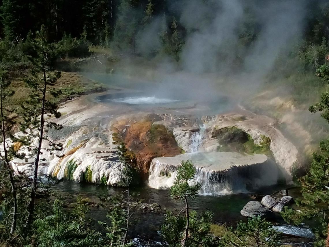
An unnamed but charismatic thermal feature alongside Ferris Fork, near the Bechler River. The center of the pool is roiling with gas bubbles, but not boiling! The pool is only about 180 degrees F (81 degrees C), and all the gas is bubbling up from underground. The white color is due to the silica-saturated water depositing sinter as it flows out and cools, while the red and green patches are cooler areas where algal mats thrive.
Earthquake sequences like these are common and account for roughly 50% of the total seismicity in the Yellowstone region.
Yellowstone earthquake activity remains at background levels.
Ground deformation
Subsidence of Yellowstone Caldera, which has been ongoing since 2015, has paused during the summer months, reflecting seasonal groundwater recharge. Every summer, water from snow melt causes the ground to swell slightly, resulting in a pause in subsidence trends or even a minor amount of uplift (less than 1 cm / fraction of an inch). In the area of Norris Geyser Basin, no significant uplift or subsidence has been detected by a nearby GPS station since the start of 2020.
Source : YVO.
Photos : Mara Reed , Sara Peek .
Hawaii , Kilauea :
19°25’16 » N 155°17’13 » W,
Summit Elevation 4091 ft (1247 m)
Current Volcano Alert Level: WARNING
Current Aviation Color Code: RED
Activity Summary:
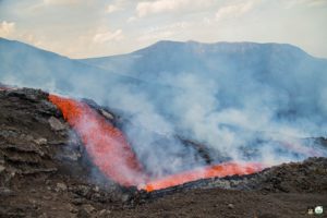
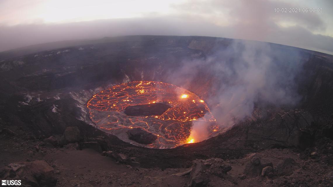
Kīlauea volcano is erupting. Lava continues to erupt from multiple vents along the floor and western wall of Halemaʻumaʻu crater. As of the morning of October 1, 2021, all lava activity is confined within Halemaʻumaʻu, in Hawai’i Volcanoes National Park. Seismicity and volcanic gas emission rates remain elevated.
Around 6 p.m. HST on September 30, 2021, Kīlauea’s new eruption in Halema‘uma‘u continued with vigorous fountain activity at the new vent on the western crater wall. This view is from the south caldera rim looking to the west at the approximately 15 m (50-ft) high fountain measured over a five minute interval. This photo was taken from a closed area of Hawai‘i Volcanoes National Park.
Summit Observations:
Sulfur dioxide (SO2) emission rates remain high and were estimated at around 20,000 tonnes per day the morning of September 30, 2021. This is significantly lower than the initial emission rates of 85,000 tonnes per day that were measured just after the eruption started on the afternoon of September 29, 2021. Seismicity is stable, with few earthquakes and ongoing eruptive tremor. Summit tiltmeters continued to record slowing deflationary tilt through the last 24 hours.
Halemaʻumaʻu Lava Lake Observations:
Lava continues to erupt from multiple vents on the base and west wall of Halemaʻumaʻu, though the number of active fountaining locations has decreased over the past day. The rate of lava lake rise has slowed since the early phase of the eruption. Over the past 24 hours, the lava lake surface has risen approximately 4 meters (4.4 yds). In total, the lava lake surface has risen approximately 24 m (26 yds) since the eruption started. Localized and discontinuous crustal foundering continues (a process by which cool lava crust on the surface of the lava lake is overridden by less-dense liquid from below causing the crust to sink into the underlying lake lava). Last night, field crews reported maximum fountain heights of 15 m (49 ft) at the dominant vent on the west wall of Halemaʻumaʻu. Low fountaining continues at other sources, which are less vigorous.
Observations de la zone du Rift Est :
Aucune activité inhabituelle n’a été notée dans la zone du Rift Est du Kīlauea . Le mouvement de déformation du sol suggère que la zone supérieure du Rift Est – entre le sommet et Pu’u’ō’o – s’est régulièrement remplie de magma au cours de l’année écoulée. Les émissions de SO2 et de sulfure d’hydrogène (H2S) de Pu’u’ō’ō étaient inférieures aux niveaux de détection instrumentale lors de la dernière mesure le 7 janvier 2021.
Source : HVO.
Photos : USGS / K. Lynn. USGS Webcam.
Iceland , Reykjanes Peninsula :
Six months after the earthquakes on the Reykjanes Peninsula subsided, a new swarm of earthquakes broke out in Fagradalsfjall.
More than 60 earthquakes have been recorded near Mount Keilir since midnight. The largest was M 3.5 at eleven o’clock this morning and was felt in the capital region. The earthquake started near the mountain on Monday and the epicenter was reported to be about five to seven kilometers deep.
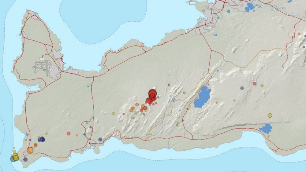
About 160 earthquakes have been detected and they are increasing, according to Kristín Jónsdóttir, natural hazards group leader at the Icelandic Meteorological Office. « It’s a little difficult to understand what’s going on there. These earthquakes are actually in the same place and we know that the dyke formed completely to the north of it. They are at a depth of d ‘about five to seven kilometers. Of course, we cannot rule out that there is moving magma. We now see that this is the longest eruption pause, so to speak, since the 19th. March, « Kristín said in a live interview in the midday newspaper about whether there is a link between the Fagradalsfjall eruption and the current earthquakes.
The earthquake swarm began near Keilir on Monday and the earthquakes were over 100 yesterday. Dozens have occurred since midnight. The earthquake was well felt in the Radio House in Efstaleit and the Meteorological Office received reports that it was felt in many parts of the capital.
At around two o’clock last night, a magnitude 3.0 earthquake shook the region. The source of the earthquakes lies at a depth of about five to seven kilometers, and Lovísa Mjöll Guðmundsdóttir, nature conservation specialist at the Meteorological Bureau, said in conversation with the news agency that they are due either to the plate or to the magma which is on the dyke. She says it’s too early to say anything now about what the 11am earthquake means in this context.
The earthquakes lie to the north of the magma intrusion linked to the Fagradalsfjall eruption and so it is likely that there is a connection between them, but it is not possible to say with certainty, according to Lovísa Mjallar.
Civil defense is vigilant on the situation and is monitoring closely, according to Hjördís Guðmundsdóttir, chief information officer. So far, no special preparation has been taken.
Sources : Vedur is , RUV.
Carte : Service météorologique national
Photo : Birgir Þór Harðarson – RÚV.
Mexico , Popocatepetl :
CENAPRED monitoring report of the Popocatépetl volcano, October 02, 2021.
In the last 24 hours, according to the monitoring systems of the Popocatépetl volcano, 119 exhalations accompanied by water vapor, volcanic gases and a low ash content have been identified. In addition, 30 minutes of low amplitude tremor and an explosion were identified today at 02:58 h.
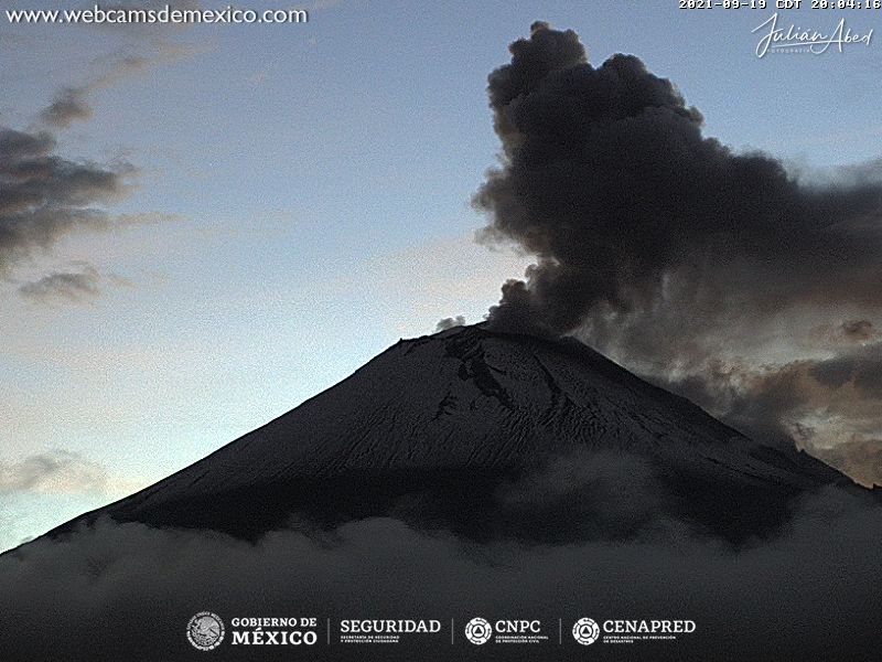
Since this morning and at the time of this report, the crater has been observed with a slight emission of water vapor, gas and slight amounts of ash in a northeast direction.
CENAPRED recommends NOT TO APPROACH the volcano and in particular the crater, because of the danger of falling ballistic fragments and, in the event of heavy rains, to stay away from the bottom of the ravines because of the danger. mudslides and debris.
Source et photo : Cenapred.