July 02 , 2023.
La Réunion , Piton de la Fournaise :
Press release from the Institut de physique du globe de Paris, Volcanological observatory of Piton de la Fournaise, July 02, 2023 – 7:50 – 3:50 UTC
seismic crisis
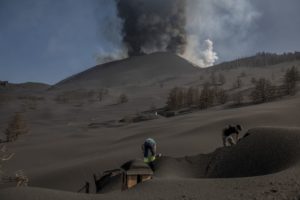
Since 07:36 local time, a seismic crisis has been recorded on the instruments of the Volcanological Observatory of Piton de la Fournaise. This seismic crisis is accompanied by rapid deformation. This indicates that magma is leaving the magma reservoir and spreading to the surface.
An eruption is likely at short notice in the next few minutes or hours.
Additional information will follow concerning the sector impacted by this magmatic propagation towards the surface.
Recommended alert level: Alert 1.
Press release from the Paris Institute of Earth Physics, Piton de la Fournaise Volcanological Observatory, July 02, 2023 – 08:50 – 04:50 UTC
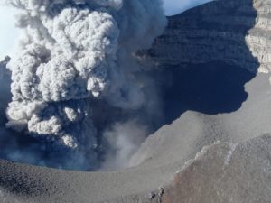
Beginning of eruption
Following the seismic crisis that began at 07:36 local time, the volcanic tremor synonymous with the arrival of magma near the surface has been recorded since around 08:30 local time.
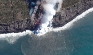
Data analysis and observations from our cameras show that the eruptive fissure(s) opened on the eastern flank of the volcano.
Eruption in progress.
Recommended alert level: Alert 2-1 (eruption in the Enclos without any particular threat to the safety of people, property or the environment)
Source : OVPF
United-States , Yellowstone :
Saturday, July 1, 2023, 6:30 AM MDT (Saturday, July 1, 2023, 12:30 UTC)
44°25’48 » N 110°40’12 » W,
Summit Elevation 9203 ft (2805 m)
Current Volcano Alert Level: NORMAL
Current Aviation Color Code: GREEN
Recent Work and News
Steamboat Geyser experienced an eruption on June 9, bringing the total number of eruptions for the year to five.
The thermal features near Doublet Pool on Geyser Hill, not far from Old Faithful, that formed and became more active in late May continued their elevated activity into the start of June. Activity diminished through the course of the month, but a small section of boardwalk between Sponge Geyser and Doublet Pool remains closed due to the proximity of thermal features that had been spattering hot water and some debris onto the pathway. The activity is occurring in the same area as, and strongly resembles, that which occurred in 2018, and is common in Yellowstone National Park, providing an example of the dynamic nature of Yellowstone’s thermal areas.
Summer field work by Yellowstone Volcano Observatory scientists during June included maintenance on semi-permanent GPS sites, water sampling, and geological studies of hydrothermal explosion craters. Field studies of the geological history of the Yellowstone region will continue throughout the month of July.
Seismicity
During June 2023, the University of Utah Seismograph Stations, responsible for the operation and analysis of the Yellowstone Seismic Network, located 78 earthquakes in the Yellowstone National Park region. The largest event of the month was a minor earthquake of magnitude 2.8 located about 17 miles north-northeast of Moran, Wyoming, on June 17 at 11:58 AM MDT.
There were no swarms in the Yellowstone region during the month.
Yellowstone earthquake activity is currently at background levels.
Ground Deformation
During the month of June, continuous GPS stations in Yellowstone Caldera recorded a pause in long-term ground subsidence, which has been ongoing since 2015 at rates of a few centimeters (about 1–2 inches) per year. A small amount of seasonal uplift (less than 1 cm, or a small fraction of an inch) has been recorded as water from snowmelt and runoff percolates into the subsurface, causing the ground to swell like a wet sponge—a style of deformation that occurs each summer. A GPS station near Norris Geyser Basin has recorded steady subsidence totaling about 3 cm (slightly more than 1 inch) since October 2022.
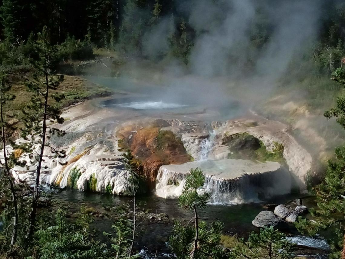
Source : YVO
Photo : thermal feature , Sara Peek
Kamchatka , Sheveluch :
VOLCANO OBSERVATORY NOTICE FOR AVIATION (VONA)
Issued: July 02 , 2023
Volcano: Sheveluch (CAVW #300270)
Current aviation colour code: ORANGE
Previous aviation colour code: orange
Source: KVERT
Notice Number: 2023-82
Volcano Location: N 56 deg 38 min E 161 deg 18 min
Area: Kamchatka, Russia
Summit Elevation: 3283 m (10768.24 ft), the dome elevation ~2500 m (8200 ft)
Volcanic Activity Summary:
A growth of the lava dome continues, a strong fumarolic activity and explosions accompanies this process. Satellite data by KVERT showed a gas-steam plume with some amount of ash extended about 39 km to the west from the volcano.
An extrusive-effusive eruption of the volcano continues. A danger of ash explosions up to 10 km (32,800 ft) a.s.l. is remains. Ongoing activity could affect international and low-flying aircraft.
Volcanic cloud height:
3500 m (11480 ft) AMSL Time and method of ash plume/cloud height determination: 20230702/0150Z – Video data
Other volcanic cloud information:
Distance of ash plume/cloud of the volcano: 39 km (24 mi)
Direction of drift of ash plume/cloud of the volcano: W / azimuth 279 deg
Time and method of ash plume/cloud determination: 20230702/0057Z – SNPP 15m16
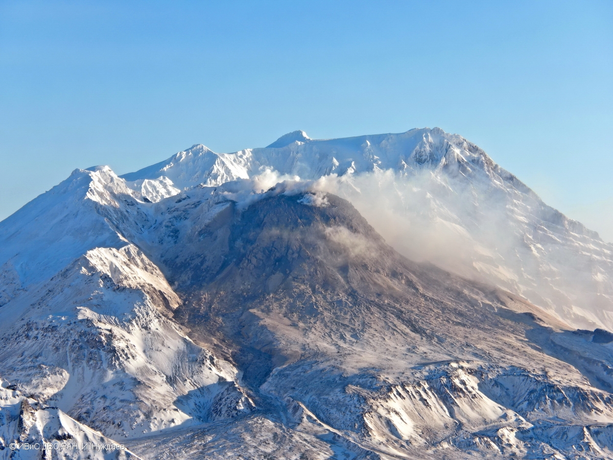
Source : Kvert
Photo : I. Nuzhdaev, IVS FEB RAS ( archive).
Philippines , Mayon :
MAYON VOLCANO BULLETIN 02 Juny 2023 8:00 AM
In the past 24-hour period, very slow effusion of lava from the summit crater of Mayon Volcano continued to feed lava flows and collapse debris on the Mi-isi (south) and Bonga (southeastern) gullies as well as rockfall and PDCs on these and the Basud (eastern) Gullies. The lava flows have advanced to approximate lengths of two thousand seven hundred (2700) meters and one thousand three hundred (1300) meters along Mi-isi and Bonga gullies, respectively, from the summit crater while collapse debris have deposited to four thousand (4000) meters from the crater. Two (2) dome-collapse pyroclastic density currents (PDC) that lasted two (2) minutes, three hundred ninety-seven (397) rockfall events, and four (4) volcanic earthquakes were recorded by the Mayon Volcano Network.
Continuous voluminous degassing from the summit crater produced steam-laden plumes that rose 1500 meters before drifting to the southwest, south-southwest and northwest direction. Sulfur dioxide (SO2) emission averaged 864 tonnes/day on 01 July 2023. Short-term observations from EDM and electronic tiltmeter monitoring show the upper slopes to be inflating since February 2023. Longer-term ground deformation parameters based on EDM, precise leveling, continuous GPS, and electronic tilt monitoring indicate that Mayon is still inflated, especially on the northwest and southeast.
Alert Level 3 is maintained over Mayon Volcano, which means that it is currently in a relatively high level of unrest as magma is at the crater and hazardous eruption within weeks or even days is possible.
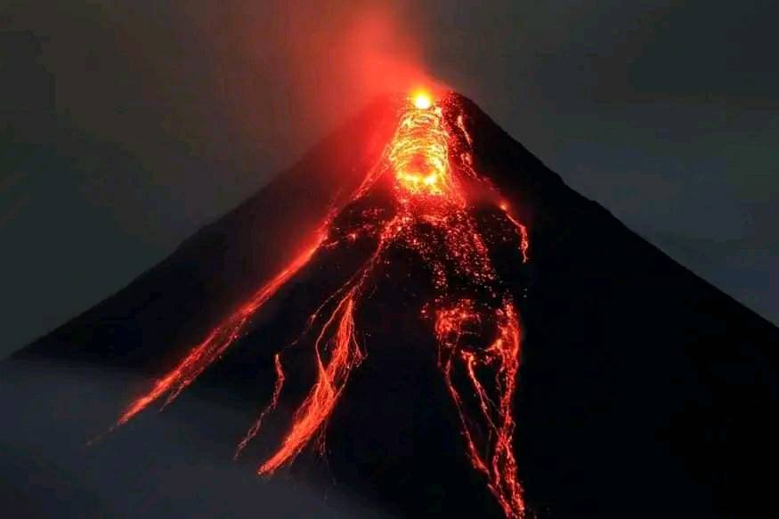
Source : Phivolcs
Photo : Lan Po Lan
Indonesia , Ibu :
G. Ibu presented an eruption on Saturday July 1, 2023 at 7:37 PM WIT. The height of the eruptive column was observed at ± 600 m above the summit (± 1925 m above sea level). The ash column was observed to be gray with thick intensity, oriented to the west. The eruption was recorded on a seismograph with a maximum amplitude of 28 mm and a duration of 59 seconds.
VOLCANO OBSERVATORY NOTICE FOR AVIATION – VONA
Issued : July 01 , 2023
Volcano : Ibu (268030)
Current Aviation Colour Code : ORANGE
Previous Aviation Colour Code : orange
Source : Ibu Volcano Observatory
Notice Number : 2023IBU015
Volcano Location : N 01 deg 29 min 17 sec E 127 deg 37 min 48 sec
Area : North Maluku, Indonesia
Summit Elevation : 4240 FT (1325 M)
Volcanic Activity Summary :
Eruption with volcanic ash cloud at 10h37 UTC (19h37 local).
Volcanic Cloud Height :
Best estimate of ash-cloud top is around 6160 FT (1925 M) above sea level or 1920 FT (600 M) above summit. May be higher than what can be observed clearly. Source of height data: ground observer.
Other Volcanic Cloud Information :
Ash cloud moving to west. Volcanic ash is observed to be gray. The intensity of volcanic ash is observed to be thick.
Remarks :
Eruption recorded on seismogram with maximum amplitude 28 mm and maximum duration 59 second.
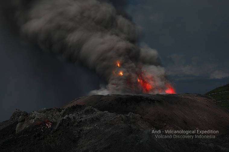
Source : Magma Indonésie .
Photo : Andi Rosati / Volcanodiscovery.