October 16 , 2021.
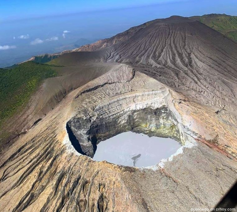
Spain / La Palma , Cumbre Vieja :
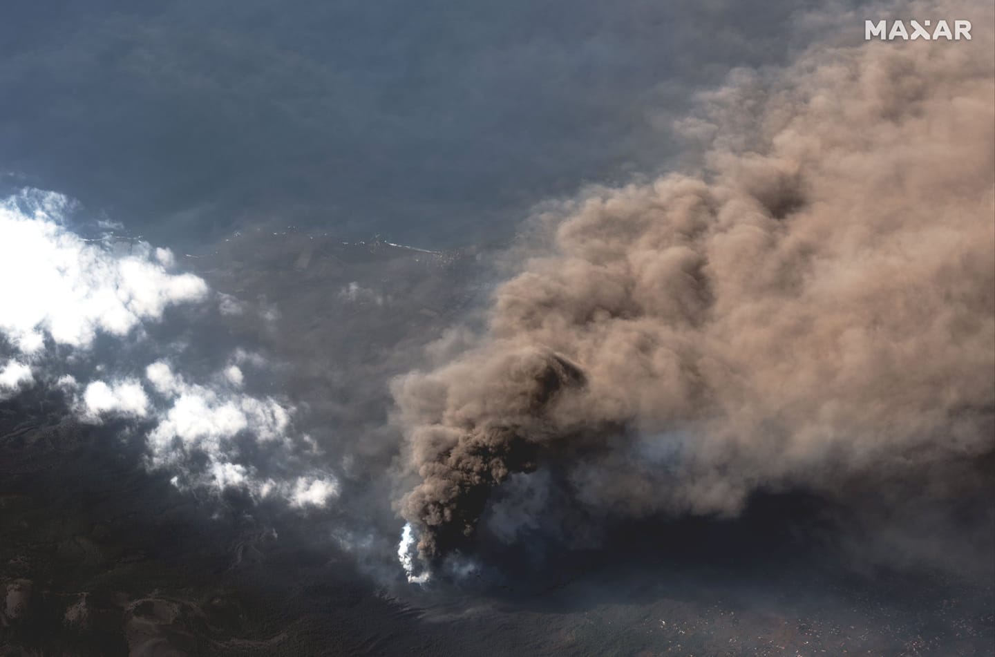
October 15, 2021, 10:00 UTC, Eruptive activity continues on La Palma.
Since the last declaration, 66 earthquakes have been located in the area affected by the volcanic reactivation of Cumbre Vieja, 4 of these earthquakes were felt by the population, the maximum intensity being in the epicentral zone IV (EMS98), during an earthquake that occurred at 07:02 UTC today, with a magnitude of 4.5 (mbLg) at 36 km depth, which was felt throughout the island. In addition, this earthquake was the largest of those located since the last declaration.
A total of 28 earthquakes were located at depths of around 30 km, 12 of which were in the form of a swarm that started at 11:59 p.m. on the 14th, with a maximum magnitude in the swarm of 3.1 mbLg. The rest of the hypocenters of the period are located at a shallower depth, about 10 km.
The volcanic tremor signal maintains a medium to high amplitude, with no intensifying pulses since the last release.
The height of the scatter cloud, measured at 08:00 UTC, is estimated at 4000 m.
The network of permanent GNSS stations on the island shows that the elevation recorded yesterday at station LP03, which is closest to the eruptive centers, has been maintained while the deformation towards the South-South-West tends to s ‘reverse.
The latest data from the La Palma volcano:
The two streams which are located south of La Laguna mountain are constantly monitored. They could converge and reach the sea, but it is still too early to be sure. There is a finger that has been separated from the most northerly flow, which is now on the Camino Cumplido, which seems to have a tendency to stick to the mountain and would not, in principle, affect the area further to the north. Northwest of La Laguna.
The air quality remains far from the risk thresholds, even if the arrival of haze could worsen the data and recommend containment. No further evacuation is planned, although this is constantly being reviewed. The total evacuees are 7,000 people. 321 are housed in the Fuencaliente hotel.
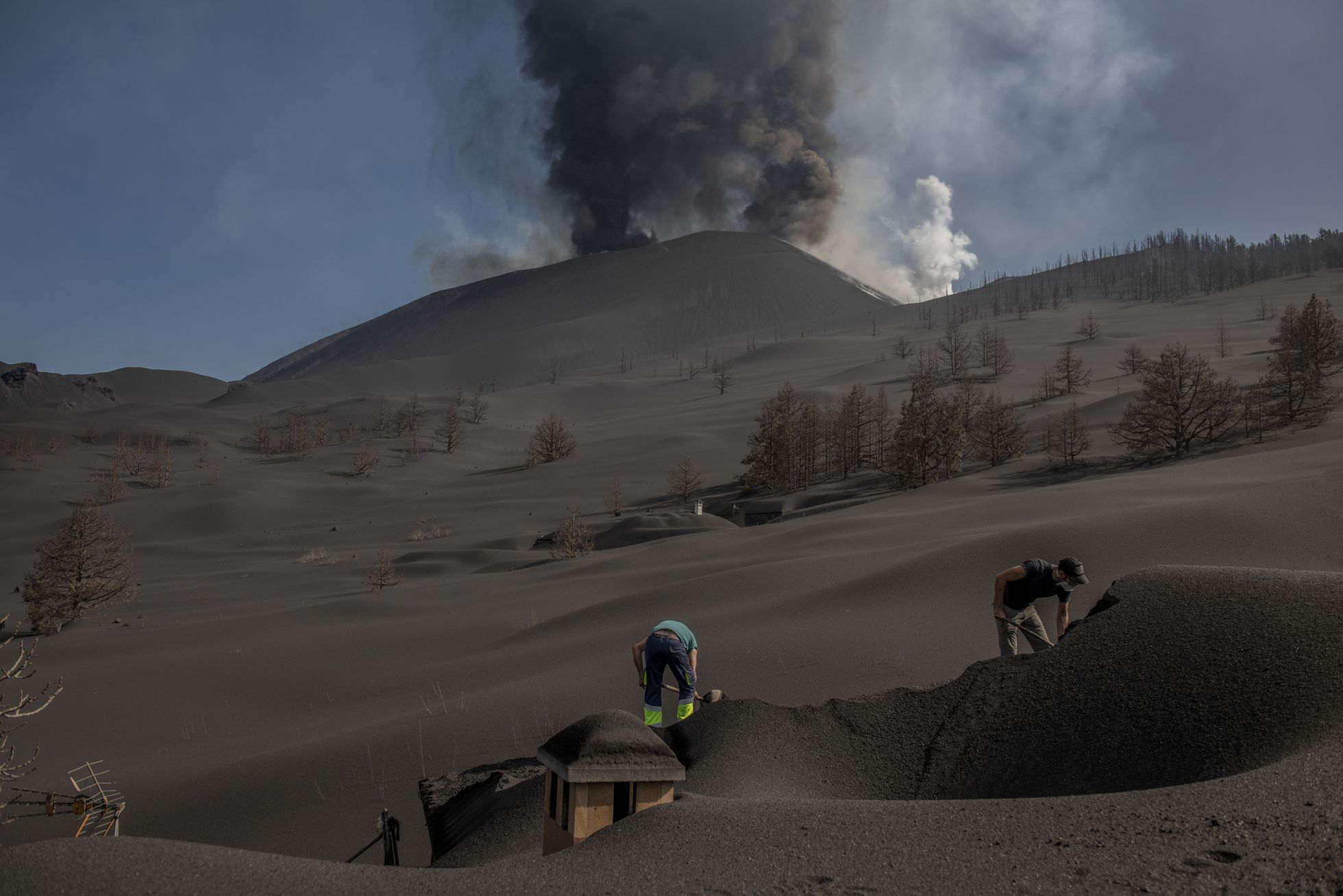
The latest data on the surface area affected by lava flows is 696 hectares.
The deformation of the local terrain at the station closest to the eruptive cone has attenuated and the rest does not show significant deformation. Currently, the effusive phase of the eruption predominates, with more lava than ash coming out. Large blocks washed away by the most northerly flow continue to be observed. The volcanic explosive index continues to be 2 on a scale of 0 to 8. The column of ash and gas reached 4000 meters this morning. The sulfur dioxide emission did not change.
Surface seismicity is low, most occurring at depths greater than 20 kilometers.
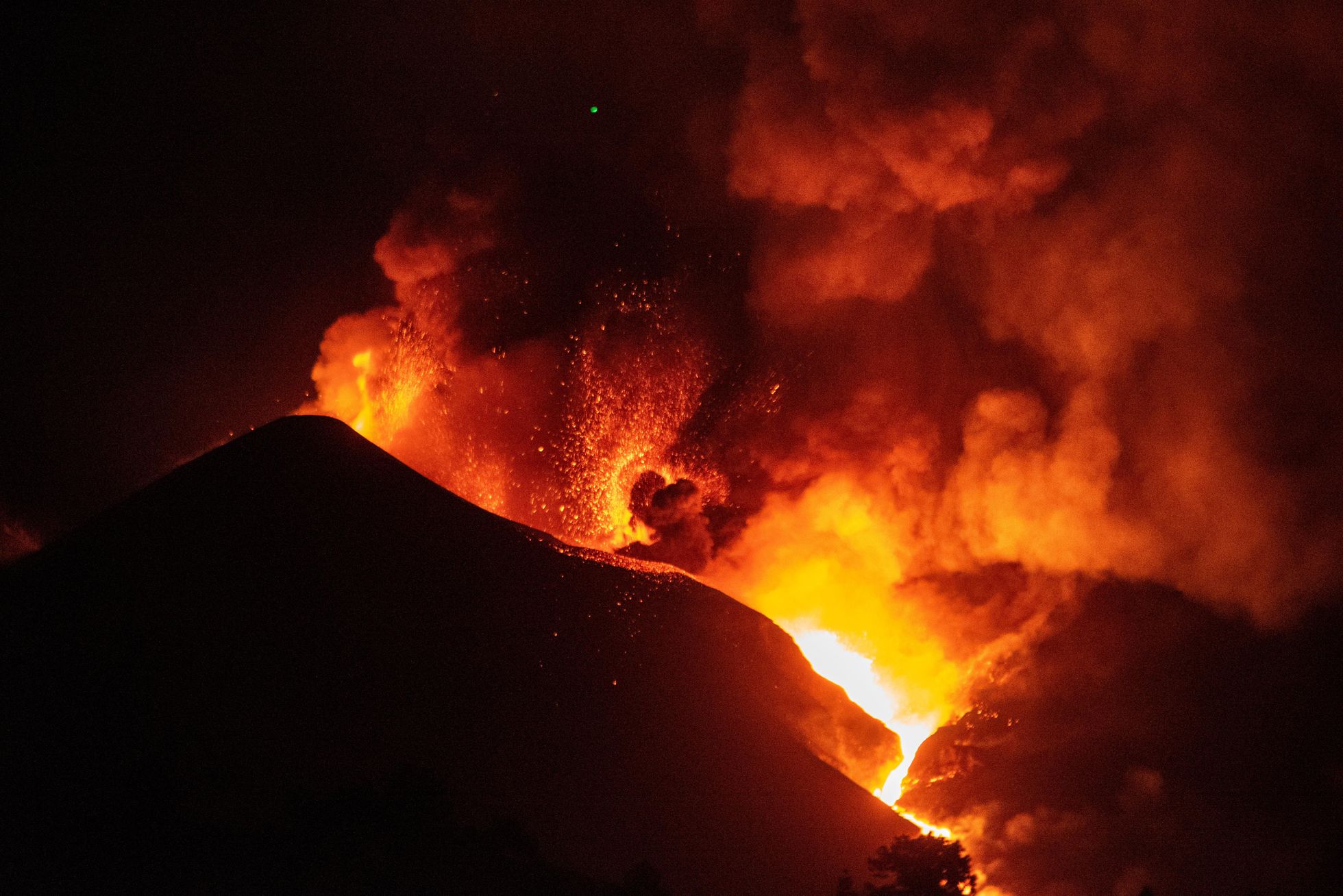
A new eruptive point has emerged on the La Palma volcano in the area of the main cone, which expels gas and ash, but does not emit lava at the moment, according to Pevolca sources. Those responsible for the volcanic emergency plan for the Canary Islands are currently trying to collect all the data on this new point of eruption. They claim that, from what they observed, this is a normal process in this type of eruption and has happened before in the nearly four weeks that this volcano has been active. According to the Canary Islands Volcanological Institute (Involcan), the new eruptive point is located southeast of the main cone and expels ash and pyroclasts (fragments of volcanic material of different sizes). The new mouth is aligned with the other three emission centers that remain active in the eruption.
Source : IGNes
Photos : Maxar. El Pais , El Pais / MIGUEL CALERO.
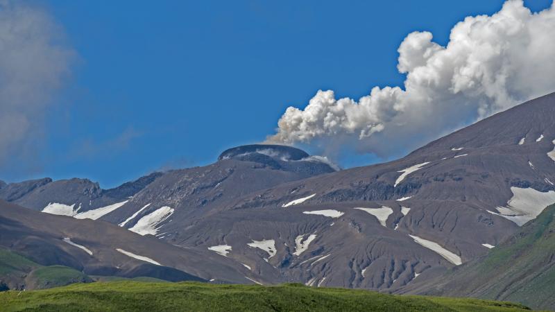
Indonesia , Merapi :
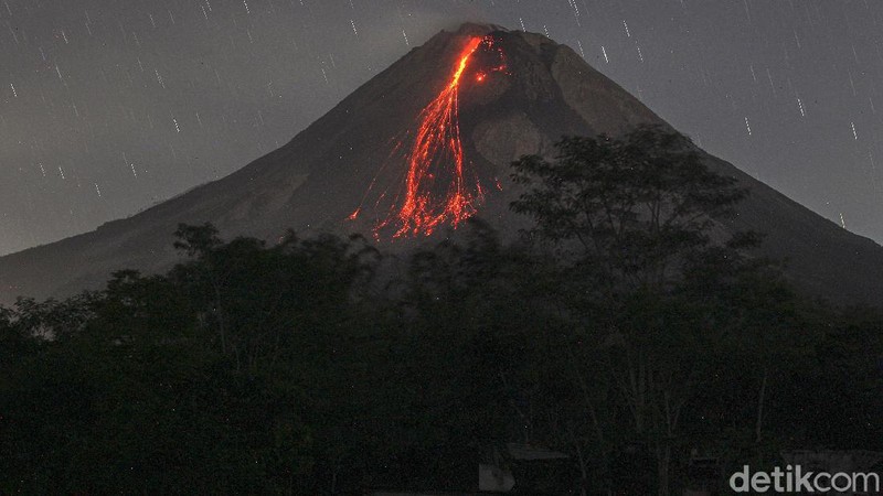
Mount Merapi Activity Report October 8-14, 2021
OBSERVATION RESULT
Visual
The weather around Mount Merapi is generally sunny in the morning and evening, while it is foggy in the afternoon. White fumes, weak to thick, of low pressure and 300 m high were observed from the observation post of Mount Merapi of Babadan on October 12, 2021 at 06:00 WIB. Lava avalanches have been observed 41 times to the southwest with a maximum slide distance of 2000 m.
It was observed that the height of the southwest lava dome decreased by ± 2 m and the height of the central lava dome increased by approximately ± 4 m. The volume of the southwest lava dome is 1,609,000 m3 and the central dome is 2,927,000 m3.
Seismicity
This week, the seismicity of Mount Merapi showed
1 shallow volcanic earthquake (VTB),
133 low frequency earthquakes (LF),
1,465 multi-phase earthquakes (MP),
1,123 avalanche earthquakes (RF),
167 emission earthquakes (DG),
11 tectonic earthquakes (TT).
This week’s seismicity intensity was higher than last week.
Deformation
The deformation of Mount Merapi which was monitored using EDM and GPS this week showed no significant changes.
Rain and lahars
This week, it rained at the Mount Merapi observation post with an intensity of 18 mm / hour for 30 minutes at Kaliurang post on October 8, 2021. There were no reports of lahars or additional flow in the mountains. rivers that originate from Mount Merapi.
Conclusion
Based on the results of visual and instrumental observations, it is concluded that:
The volcanic activity of Mount Merapi is still quite high in the form of effusive eruption activity. The state of the activity is defined in the « SIAGA » level .
Source : BPPTKG.
Photo : Detik .com.
Costa Rica , Turrialba / Poas / Rincon de la Vieja :
Volcanic Watch Program Weekly Bulletin
Turrialba volcano
Lat: 10.025 ° N; Long: 83.767 ° W;
Height: 3340 m.s.n.m.
Current activity level: 2 (active volcano)
Potentially associated hazards: gas, ash emission, proximal ballistic projections, acid rain.
The number of low-frequency volcanic earthquakes remains stable, around 100 events, there were almost no VT-type events. Geodetic monitoring shows a slight contraction in the region that includes the Irazú-Turrialba massif over the last 3 months, centered under the Irazú volcano.
The SO2 flow remains stable around 166 +/- 49 t / d. On Monday, October 11, no influence was detected from the Cumbre Vieja volcano in La Palma (Canary Islands) on the air quality of Costa Rica, according to the monitoring carried out by the monitoring station of gases and volcanic aerosols. of OVSICORI-UNA located in San Isidro de Coronado.
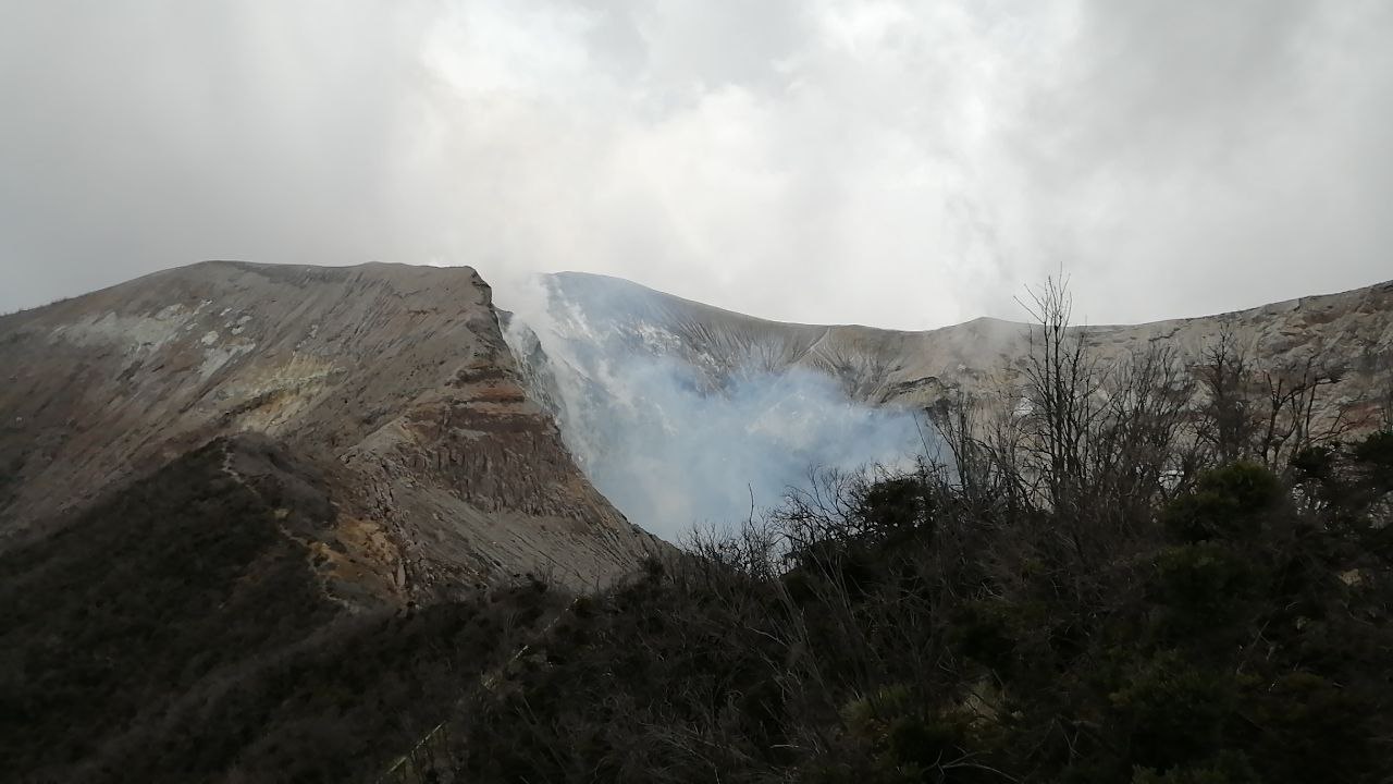
Poas volcano
Lat: 10.2 ° N; Long: 84.233 ° W;
Height: 2780 m.s.n.m.
Current activity level: 2 (active volcano)
Potentially associated hazards: gas, phreatic eruptions, proximal ballistic projections, acid rain.

No phreatic eruption was observed. The seismic activity (daily number of events of type LP, VT and short tremor) remains stable, within the limits of normal variations. Short tremors which are in fact LP type events exhibit a chaotic pattern of occurrence with varying amplitudes. Geodetic monitoring does not show any significant deformation during the last 3 months. The SO2 flux continues to show a decrease, currently being calculated, only 21 +/- 9 t / d, the lowest measured in 2021. The subaerial fumaroles in the eastern sector of the crater have maintained a low flow of water vapor and temperatures below 90 degrees Celsius. The level of the hyperacid lake remained stable over the week and the color remains pale green indicating a low flow of magmatic gas entering the lake.
Rincón de la Vieja volcano
Lat: 10.83 ° N; Long: 85.324 ° W;
Height: 1895 m.s.n.m.
Current activity level: 2 (active volcano)
Potentially associated hazards: lahars, gas, phreatic eruptions, proximal ballistic projections, acid rain.
No eruption was detected. Seismic activity remains low with a low RSEM level, a marked decrease in the number of « tornillo » type signals, and a stable number of LP and VT type events (less than a dozen). Geodetic GPS monitoring shows a slight tendency to shrink.
Source : Ovsicori.
Photos : Jean Paul Calvo/RSN , crhoy.
Alaska , Great Sitkin :
52°4’35 » N 176°6’39 » W,
Summit Elevation 5709 ft (1740 m)
Current Volcano Alert Level: WATCH
Current Aviation Color Code: ORANGE
Lava effusion continued this week at Great Sitkin, and lava now fills more than half of the summit crater. Satellite imagery from October 11 showed that two lobes of lava, flowing over low points on the crater rim, extend downslope 330 m (1,085 feet) to the south and 350 m (1,150 feet) to the west. Lava has also reached the crater rim on its northern periphery. In a few areas, the lava has advanced over snow and ice but no anomalous melting, steaming, or ponding of water has been observed. This indicates that melt rates are probably low and there are no indications of any imminent hydrologic hazards.
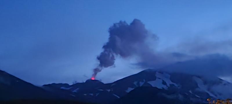
The lava lobes that have overtopped the summit crater rim are flowing into small valleys developed on the volcanic edifice. The terrain is steep in these areas, and blocks of lava and lava rubble could detach from the terminus of the flow lobes without warning and form small rock avalanches in these valleys. Such avalanches may liberate ash and gas and could travel several hundred meters beyond the lava flows; they would be hazardous to anyone in those areas. Satellite imagery shows a blocky deposit probably formed in this way extending 450 m (1,475 feet) beyond the terminus of the west flow lobe.
The level of seismicity was slightly elevated throughout the past week and there were persistent small earthquakes likely associated with the ongoing lava effusion. No explosive activity or ash emissions have been detected in seismic, infrasound, satellite, or web camera data.
There is no indication of how long lava effusion will continue during the current eruption, and it is possible that explosive activity could occur with little or no warning.
Great Sitkin Volcano is monitored by local seismic and infrasound sensors, satellite data, web cameras, and remote infrasound and lightning networks.
Source : AVO
Photos : Kruse, Peggy ; Ward, Dave .
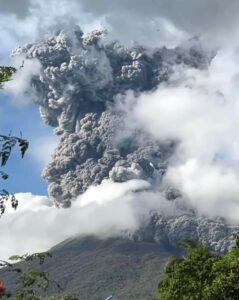
Guatemala , Fuego :
ACTIVITY :
The seismic stations reflect activity and OVFGO observers report that during the night and early morning a weak white fumarole was maintained with weak and moderate explosions in a range of 8 to 10 per hour, expelling columns of gray ash at a height of 4400 at 4,700 masl (14,436 to 15,420 feet) moving in a south and southwest direction, at a distance of approximately 15 km, with a fall of fine ash Panimaché I, El Provenir, La Rochela, Morelia, Santa Sofía and others in the communities in that direction .

They generate a low to moderate rumble with shock waves. Incandescent pulses were observed rising 300 to 350 meters above the crater. Constant boulder avalanches were heard in the direction of the ravines of Ceniza, Taniluya, Trinidad and Santa Teresa, some of the material reached the edge of the vegetation. Outgassing sounds similar to that of a train locomotive are reported in 1 minute intervals.
Source : Insivumeh
Photo : @davidrojasgtfoto