June 29 , 2023.
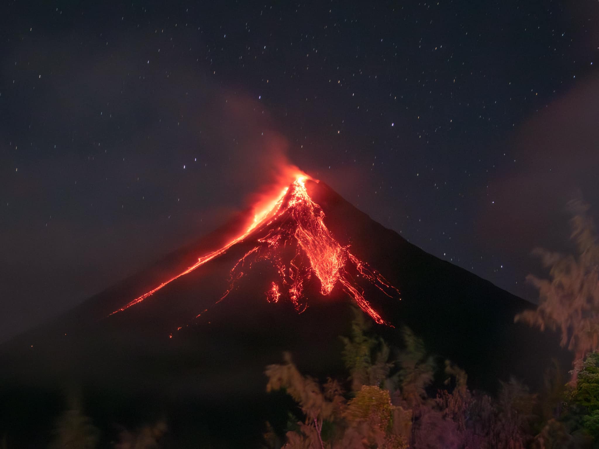
Peru , Ubinas :
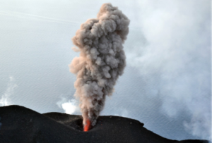
Instituto Geofísico del Perú (IGP) reported that a new eruption began at Ubinas on 22 June after three days on increased seismicity. The seismic network recorded a total of 315 volcano-tectonic earthquakes with a maximum magnitude of 1.8 and 281 long-period earthquakes. The eruption began at 00h11 on 22 June with a minor ash plume rising 1 km above the crater rim and drifted E based on seismicity and webcams.
During 23-25 June IGP reported a total of 402 volcano-tectonic earthquakes with a maximum magnitude of 1.9 and 865 long-period earthquakes. Sporadic diffuse ash emissions continued during this period that rose as high as 1.5 km above the crater rim.
On 23 June the Buenos Aires VAAC reported that diffuse ash plumes were visible in satellite images rising to 6.4 km (21,000 ft) a.s.l., or about 700 m above the summit, and drifting NE and NW. At 15h00 they noted that continuous steam emissions occasionally accompanied by diffuse ash puffs were visible in webcam images. On 24 June small diffuse ash puffs were visible in webcam and satellite images rising 6.4-7 km (21,000-23,000 ft) a.s.l., or 700-1,300 m above the summit, and drifting NW. On 25 June continuous gas emissions with sporadic diffuse ash puffs were visible in webcam images, though the ash was too diffuse to be detected in satellite images. IGP noted that no notable deformation nor thermal anomalies were detected. The Alert Level remained at Yellow (the second level on a four-color scale).
Sources : Instituto Geofísico del Perú (IGP), Buenos Aires Volcanic Ash Advisory Center (VAAC) , GVP .
Photo : IGP ( archive)
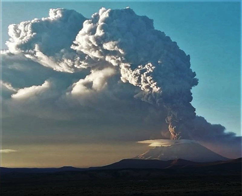
Philippines , Mayon :
MAYON VOLCANO BULLETIN 29 June 2023 8:00 AM
In the past 24-hour period, very slow effusion of lava from the summit crater of Mayon Volcano continued to feed lava flows and collapse debris on the Mi-isi (south) and Bonga (southeastern) gullies. The lava flows have advanced to approximate lengths of two thousand one hundred (2100) meters and one thousand three hundred (1300) meters along Mi-isi and Bonga gullies, respectively, from the summit crater while collapse debris have deposited to three thousand three hundred (3300) meters from the crater. A total of seven (7) dome-collapse pyroclastic density currents (PDC) that lasted three (3) minutes, two (2) lava front collapse pyroclastic density currents (PDC) that generated 1000 meters high light-brown plume, two hundred ninety-six (296) rockfall events, and one (1) volcanic earthquake were recorded by the Mayon Volcano Network.
Continuous moderate degassing from the summit crater produced steam-laden plumes that rose 1000 meters before drifting to west-northwest, north-northwest and northeast direction. Sulfur dioxide (SO2) emission averaged 595 tonnes/day on 28 June 2023. Short-term observations from EDM and electronic tiltmeter monitoring show the upper slopes to be inflating since February 2023. Longer-term ground deformation parameters based on EDM, precise leveling, continuous GPS, and electronic tilt monitoring indicate that Mayon is still inflated, especially on the northwest and southeast.
Alert Level 3 is maintained over Mayon Volcano, which means that it is currently in a relatively high level of unrest as magma is at the crater and hazardous eruption within weeks or even days is possible.
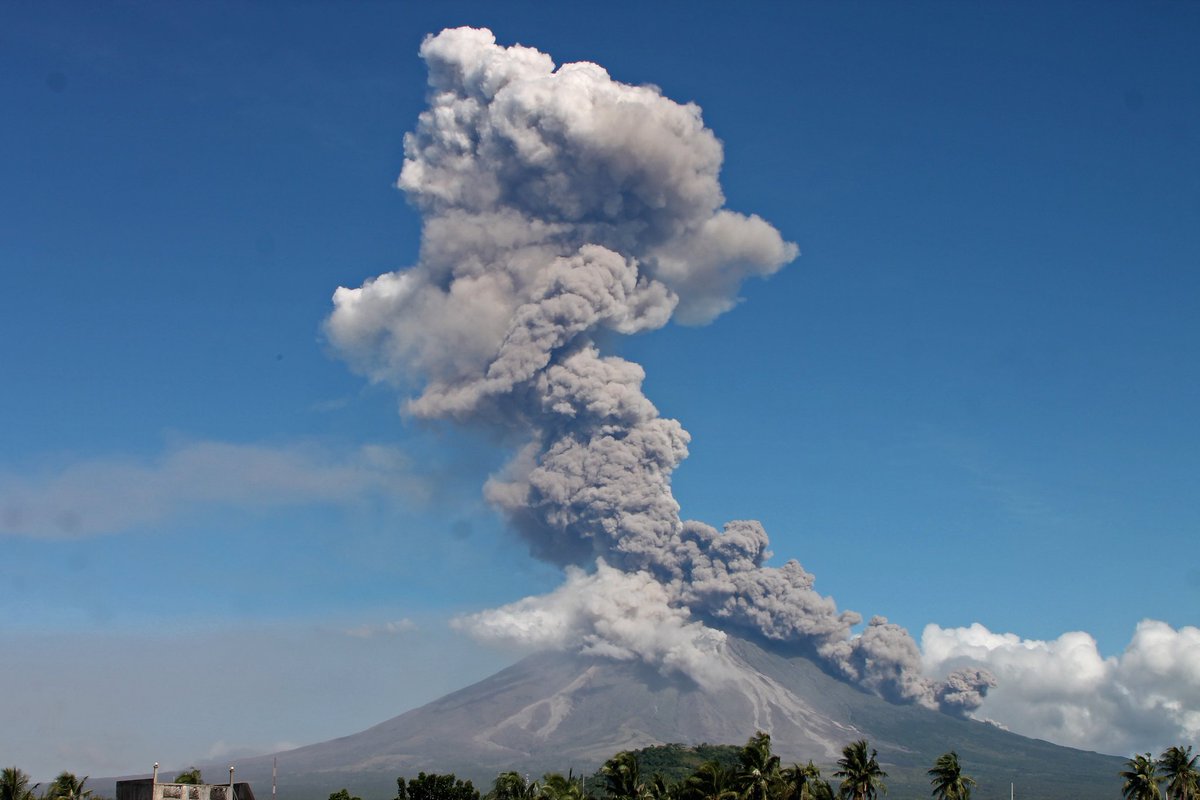
On 26 June PHIVOLCS released an advisory due to increased seismic activity and ground deformation, noting that the number of volcano-tectonic earthquakes increased during the week; there were two during 20-21 June, two during 23-24 June, and 107 during 26-27 June. The increased seismicity was accompanied by a sharp increase in ground tilt on the SW part of the volcano. The Disaster Response Operations Monitoring and Information Center (DROMIC) reported that as of 16h00 on 27 June, the increased unrest had affected a total of 41,488 people and displaced a total of 20,138 people from 26 barangays within the province of Albay. The Alert Level remained at 3 (on a 0-5 scale). Residents were reminded to stay away from the 6-km-radius Permanent Danger Zone (PDZ), and PHIVOLCS recommended that civil aviation authorities advise pilots to avoid flying close to the summit.
Source : Phivolcs, GVP.
Photos : Rick Estillomo, auteur inconnu.
Guatemala , Santiaguito :
14°44′ 33˝ latitude North; 91°34’13˝ West longitude.
Height: 0.2500m.
Weather conditions: Clear weather
wind: East
Precipitation: 33.4 mm.
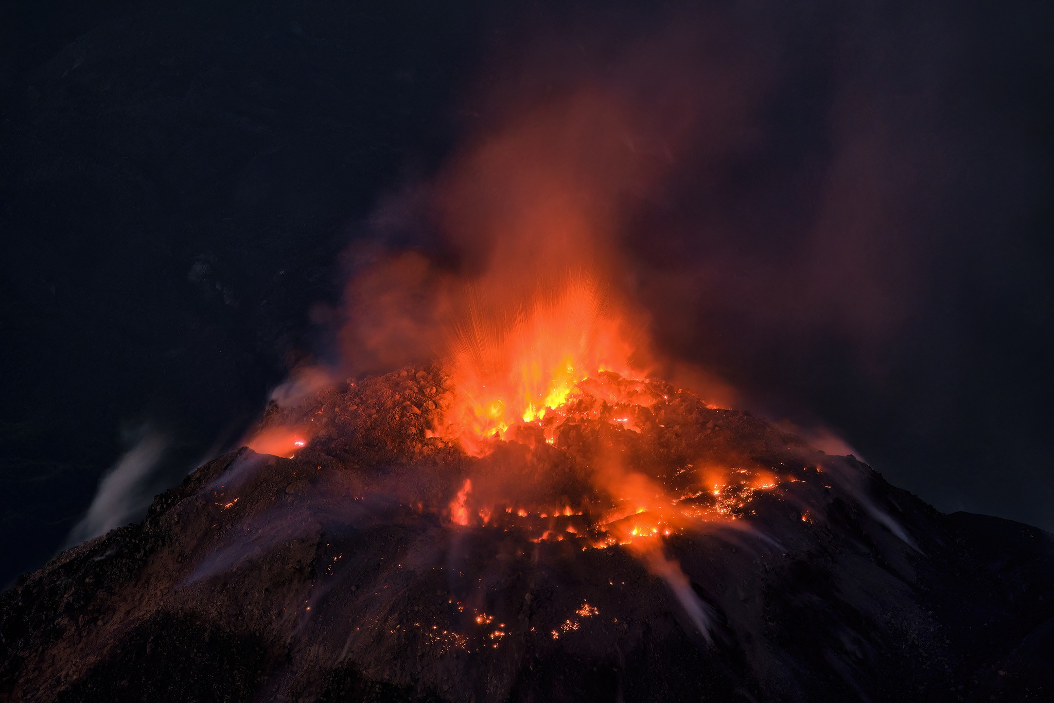
Activity:
A sparse and weak degassing is recorded, with some increasing pulses on the Caliente dome, this degassing disperses towards the West. During the night and early in the morning, an incandescence was observed in the cupola of the dome. Seismic stations continue to record weak explosions, which generate avalanches from the dome in all directions. This can cause fine ash particles to fall and a hazy atmosphere near the volcano. Strong avalanches and audible sounds are possible several kilometers from the volcanic edifice. The appearance of block and ash flows of moderate to strong characteristics is not excluded, as well as possible pyroclastic flows over long distances in different directions.
Source : Insivumeh.
Photo : Thomas Spinner via FB .
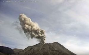
Japan , Suwanosejima :
JMA reported that the eruption at Suwanosejima’s Ontake Crater continued at low levels during 21-27 June. At 1521 on 25 June an eruptive event produced an ash plume that rose 1.3 km above the crater rim and drifted to the N, and ejected a large block 100 m from the crater. At 0036 on 27 June an ash plume rose 1.2 km and drifted N, followed by another at 0909 that rose 1.8 km and drifted E. The Alert Level remained at 2 (on a 5-level scale) and the public was warned to stay at least 2 km away from the crater.
The 8-km-long island of Suwanosejima in the northern Ryukyu Islands consists of an andesitic stratovolcano with two historically active summit craters. The summit is truncated by a large breached crater extending to the sea on the east flank that was formed by edifice collapse. One of Japan’s most frequently active volcanoes, it was in a state of intermittent Strombolian activity from Otake, the NE summit crater, between 1949 and 1996, after which periods of inactivity lengthened. The largest recorded eruption took place in 1813-14, when thick scoria deposits blanketed residential areas, and the SW crater produced two lava flows that reached the western coast. At the end of the eruption the summit of Otake collapsed, forming a large debris avalanche and creating the open Sakuchi caldera, which extends to the eastern coast. The island remained uninhabited for about 70 years after the 1813-1814 eruption. Lava flows reached the eastern coast of the island in 1884. Only about 50 people live on the island.
Source :Japan Meteorological Agency (JMA), GVP.
Photo : Masanori Genko .
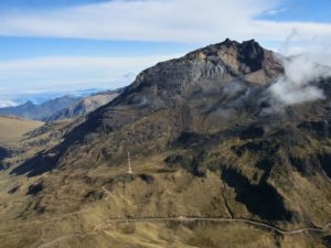
Colombia , Puracé – Los Coconucos Volcanic Range :
Puracé Volcano Weekly Activity Bulletin – Los Coconucos Volcanic Range
From the monitoring of the activity of the PURACÉ VOLCANO – VOLCANIC CHAIN OF LOS COCONUCOS, the MINISTRY OF MINES AND ENERGY through the COLOMBIAN GEOLOGICAL SERVICE (SGC) reports that:
During the week between June 20 and 26, 2023, the seismic activity showed a similar trend to that observed in previous weeks, both in energy released and in the number of events recorded, maintaining the predominance of seismic events related to the movement of fluids in the volcanic conduits, which were mainly under the crater of the Puracé volcano. This activity was accompanied by localized deformations in the upper part of the volcanic chain.
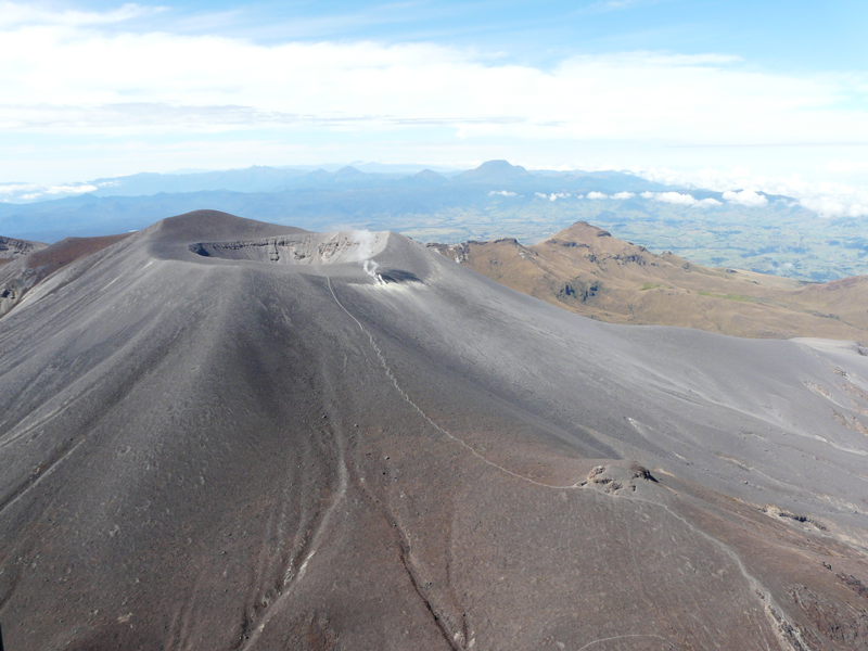
Likewise, degassing continued to be highlighted in the upper part of the volcano with a white column, preferentially oriented towards the northwest, with stable values in the fluxes of sulfur dioxide (SO2). The concentration of carbon dioxide (CO2) in the crater area of the Puracé volcano remained at high values compared to its baseline.
The other parameters measured and used for the diagnosis of volcanic activity did not show significant changes during the period evaluated.
The activity level of the volcano remains at YELLOW LEVEL (III): CHANGES IN THE BEHAVIOR OF VOLCANIC ACTIVITY
Source et photo : SGC
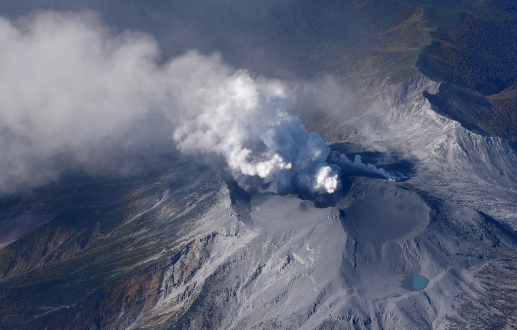
Iceland , Askja :
Askja volcano continues to inflate at a steady rate and there is currently no indication of an escalation in activity. Inflation has been steady since the end of September 2021 .16.6.2023
Deformation measurements (GPS and InSAR analysis) indicate that inflation at Askja is continuing at a constant rate since the end of September 2021. Total vertical displacements at GPS station OLAC (on the western edge of Öskjuvatn) have now reached 60 cm since the start of unrest (August 2021). Deformation modeling suggests the top depth of the inflation source is around 2.5-2.9 km below the caldera floor. The source of the deformation has not changed since September 2021.
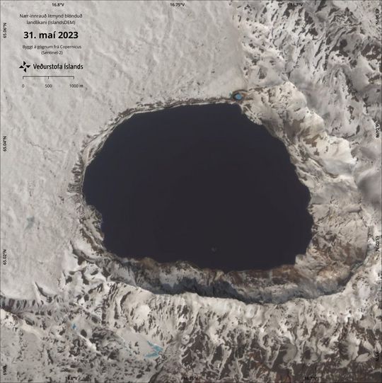
Satellite image from May 31 showing Askjuvatn and its immediate surroundings.
Since the end of 2021 until June 2023 seismic activity has been rather stable in Askja and around 20-60 earthquakes (>M0.5) have been detected there each month. The largest earthquakes each month have ranged from M2 up to M3.1. When the deformation was fastest in September 2021 up to 150 earthquakes were detected there that month.
The IMO (Icelandic Meteorological Office) monitors Askja volcano with a network of seismometers, GPS instruments and data from satellites. Satellite images show that the caldera lake in Askja has been ice free since the end of May like other waters in the area.
Source et photo : IMO.