July 21 , 2022.
Colombia , Chiles / Cerro Negro :
Weekly activity bulletin of the Chiles and Cerro Negro volcanoes
Volcano activity continues in: YELLOW LEVEL ■ (III): CHANGES IN THE BEHAVIOR OF VOLCANIC ACTIVITY.
From monitoring the activity of the CHILES AND CERRO NEGRO VOLCANOES, the COLOMBIAN GEOLOGICAL SERVICE (SGC) reports that:
For the period assessed between July 12 and July 18, 2022, changes in the behavior of volcanic activity continued. These changes, which were accentuated by the seismic swarm process of events associated with the fracture of the rock inside the volcanic system, which began on May 27, 2022, presented fluctuations, both in the number and in the seismic energy released daily. This seismic manifestation is part of a process of ground deformation (observed instrumentally) which began at the end of March 2022.

During this week, 15,086 earthquakes were recorded, with the predominance of events associated with the fracture, which were located mainly near the summit and south of the Chiles volcano, with epicentral distances up to 3 km, 5 km and depths less than 6 km. from its summit (4700 m altitude). Twenty-two (22) of these events had local magnitudes greater than M2.0, two of which were reported to be felt within the volcanic influence zone, recorded on July 12 at 6:01 p.m. with a magnitude of 3.2 and the July 16 at 10:38 a.m., magnitude 3.3.
In addition, during the week, the number of low energy earthquakes associated with the movement of fluids within the volcanic system increased, highlighting July 17 with the occurrence of 60 earthquakes, i.e. l highest daily record since permanent monitoring began in November 2013.
Source : Sernageomin.
Photo : IGEPN
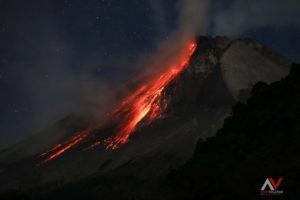
Kamchatka , Sheveluch :
VOLCANO OBSERVATORY NOTICE FOR AVIATION (VONA)
Issued: July 20 , 2022
Volcano: Sheveluch (CAVW #300270)
Current aviation colour code: ORANGE
Previous aviation colour code: orange
Source: KVERT
Notice Number: 2022-79
Volcano Location: N 56 deg 38 min E 161 deg 18 min
Area: Kamchatka, Russia
Summit Elevation: 3283 m (10768.24 ft), the dome elevation ~2500 m (8200 ft)
Volcanic Activity Summary:
A growth of the lava dome continues, a strong fumarolic activity, and an incandescence of the lava dome, explosions, and hot avalanches accompanies this process. Video and satellite data by KVERT showed a plume of resuspended ash up to 4.5 km a.s.l. extending to the south-east from the volcano.
The extrusive eruption of the volcano continues. Ash explosions up to 10-15 km (32,800-49,200 ft) a.s.l. could occur at any time. Ongoing activity could affect international and low-flying aircraft.
Volcanic cloud height:
4500 m (14760 ft) AMSL Time and method of ash plume/cloud height determination: 20220720/2050Z – Himawari-8
Other volcanic cloud information:
Distance of ash plume/cloud of the volcano: 65 km (40 mi)
Direction of drift of ash plume/cloud of the volcano: SE / azimuth 135 deg
Time and method of ash plume/cloud determination: 20220720/2050Z – Himawari-8
KVERT reported that the ongoing eruption at Sheveluch was characterized by explosions, hot avalanches, and lava-dome extrusion. A thermal anomaly was identified in satellite images during 7-14 July. Satellite images showed ash plumes drifting 82 km SW and SE during 11-13 July. The Aviation Color Code remained at Orange (the second highest level on a four-color scale). Dates are based on UTC times; specific events are in local time where noted.
Source : Kvert. GVP.
Photo : Tom Pfeiffer / VolcanoDiscovery .
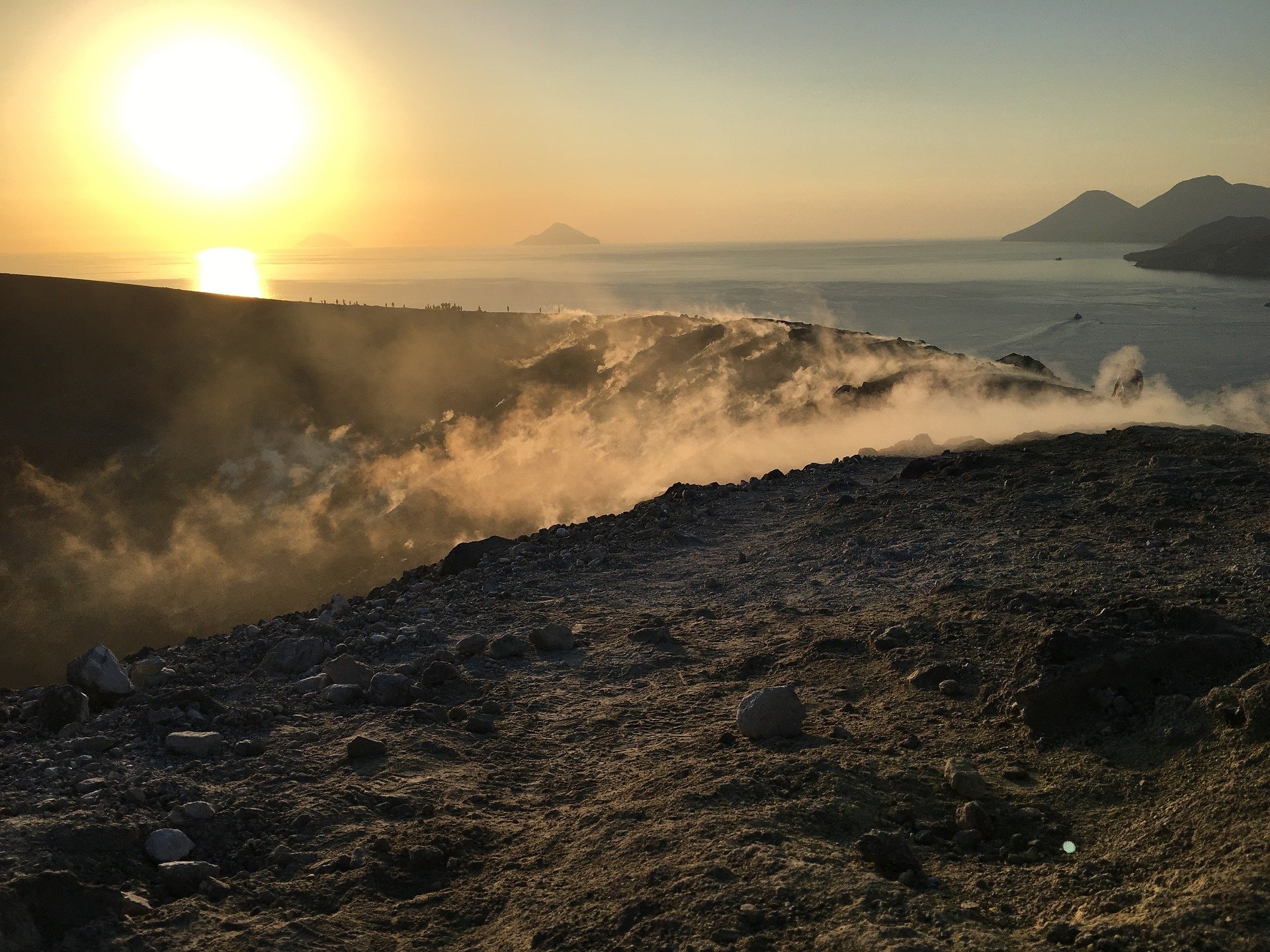
Italy , Vulcano :
WEEKLY BULLETIN from July 07, 2022 to July 07, 2022 (Issue date July 19, 2022)
ACTIVITY STATUS SUMMARY
In the light of the surveillance data, it is highlighted:
1) Temperature of the crater fumaroles: The temperatures recorded on the rim of the crater show very stable values with a weekly average of 376°C.
2) CO2 flux in the crater area: The CO2 flux in the crater area remains at medium-high values.
3) SO2 flux in the crater area: SO2 flux at a medium-high and stable level.
4) Geochemistry of fumarolic gases: There are no updates. A sample will be taken in the next few days.
5) CO2 fluxes at the base of the La Fossa cone and in the Vulcano Porto area: The CO2 fluxes recorded in the Rimessa and P4max sites show a slight downward trend, but remain at values above the level of background, while in the Faraglione site values close to the background level are recorded.
6) Geochemistry of thermal aquifers: The physico-chemical parameters recorded in the Camping Sicilia well show unreliable values due to problems with the probe that will be replaced at the end of the current month. The level and conductivity values measured in the Bambara well do not show any significant variations.
7) Local seismicity: Low rate of occurrence of local micro-seismicity with a spectral peak greater than 1 Hz. Moderate increase in the daily number of low frequency events (VLP type).
8) Regional seismicity: No earthquake with Ml >= 1.0 was located in the Vulcano region last week.
9) Deformations – GNSS: The network of GNSS stations has not recorded any significant changes.
10) Deformations – Inclinometry: The inclinometric network has not recorded any significant changes.
11) Gravimetry: No significant medium-long term variation was recorded.
12) Other Notes: Mobile GNSS. The GNSS mobile network acquires and transmits movements in real time at a frequency of 1 Hz. The time series acquired so far do not show significant variations.
CO2 FLOW AT THE BASE OF THE CONE DE LA FOSSA AND IN THE PORTO VULCANO AREA:
CO2 fluxes at the base of the crater in the C. Sicilia site are slightly higher than the previous week; In recent days, a technical verification and field measurements have been carried out at this site, which has confirmed the validity of the data acquired so far. The Rimessa site recorded values just above the background level and stable compared to last week; the P4max site shows slightly decreasing values; in the Faraglione site, there are values close to the background level.
Source : INGV
Photos : Ketty Zambuto via Vulcano Trekking.
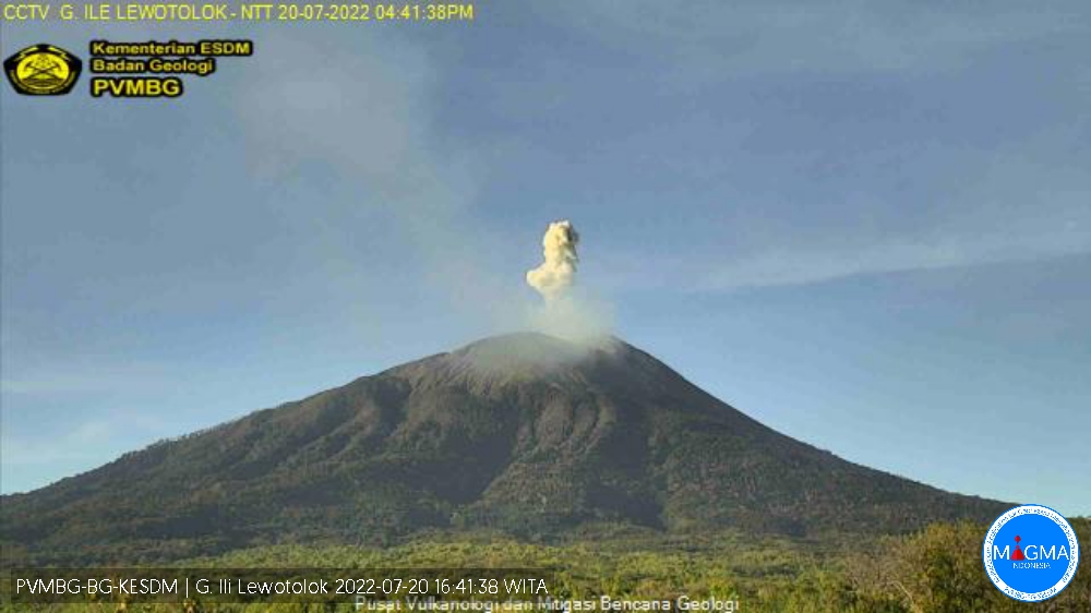
Indonesia , Ili Lewotolok :
Mount Ili Lewotolok erupted on Wednesday July 20, 2022 at 4:40 p.m. WITA with an ash column height observed at ± 700 m above the peak (± 2123 m above sea level). The ash column was observed to be white / gray in color with low / moderate intensity, oriented towards the West. This eruption was recorded on a seismograph with a maximum amplitude of 17.5 mm and a duration of 30 seconds.
VISUAL OBSERVATION
The volcano is clearly visible. Smoke from the main crater is white with low/medium intensity rising about 100-200 meters above the summit. The weather is sunny, the wind is weak to moderate from the West.
The air temperature is around 21-32.8°C. Humidity 54.7-83.1%.
SEISMICITY OBSERVATION
8 emission earthquakes with an amplitude of 1.2 to 2.8 mm and a duration of 18 to 72 seconds.
2 Tornillo type earthquakes with an amplitude of 2.1 to 12.6 mm and a duration of 7 to 15 seconds.
1 shallow volcanic earthquake with an amplitude of 1.3 mm and a duration of 10 seconds.
1 local tectonic earthquake with an amplitude of 5.2 mm, S-P 7 seconds and an earthquake duration of 37 seconds.
Continuous tremor with an amplitude of 0.5 mm, dominant value 0.5 mm.
Based on the results of an in-depth analysis and assessment, until July 13, 2022, the activity level of the Ili Lewotolok volcano is still at level III (SIAGA) with recommendations adapted to the latest potential dangers.
PVMBG reported that the eruption at Lewotolok continued during 12-19 July. Daily white or white-and-gray emissions rose as high as 800 m above the summit and drifted in multiple directions. Photos in some posted reports showed Strombolian activity from the crater. The Alert Level remained at 3 (on a scale of 1-4) and the public was warned to stay 3 km away from the summit crater and 4 km away from the crater on the SE flank.
Source : Magma Indonésie , GVP .
Photo : Magma Indonésie .
Japan , Suwanosejima :
JMA reported that the eruption at Suwanosejima’s Ontake Crater continued during 11-18 July. There were 13 explosions, producing eruption plumes that rose as high as 1.5 km above the crater rim and ejecting material 700 m from the vent. Crater incandescence was observed nightly. The Alert Level remained at 2 and the public was warned to stay 1 km away from the crater.
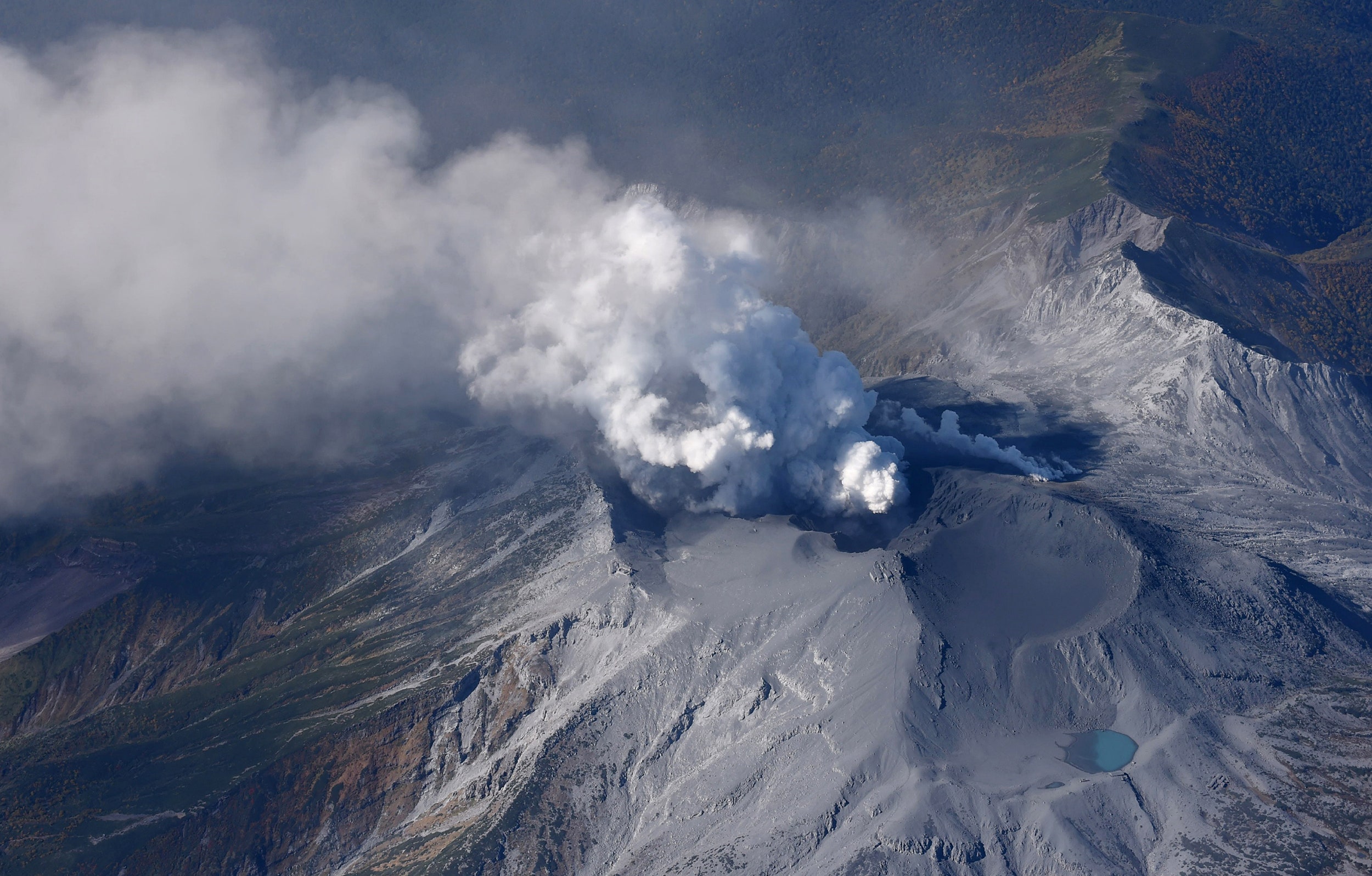
The 8-km-long, spindle-shaped island of Suwanosejima in the northern Ryukyu Islands consists of an andesitic stratovolcano with two historically active summit craters. The summit is truncated by a large breached crater extending to the sea on the east flank that was formed by edifice collapse. Suwanosejima, one of Japan’s most frequently active volcanoes, was in a state of intermittent strombolian activity from Otake, the NE summit crater, that began in 1949 and lasted until 1996, after which periods of inactivity lengthened. The largest historical eruption took place in 1813-14, when thick scoria deposits blanketed residential areas, and the SW crater produced two lava flows that reached the western coast. At the end of the eruption the summit of Otake collapsed forming a large debris avalanche and creating the horseshoe-shaped Sakuchi caldera, which extends to the eastern coast. The island remained uninhabited for about 70 years after the 1813-1814 eruption. Lava flows reached the eastern coast of the island in 1884. Only about 50 people live on the island.
Source : Japan Meteorological Agency (JMA) , GVP.
Photo : MASANORI GENKO