October 21 , 2023 .
Indonesia , Mérapi :
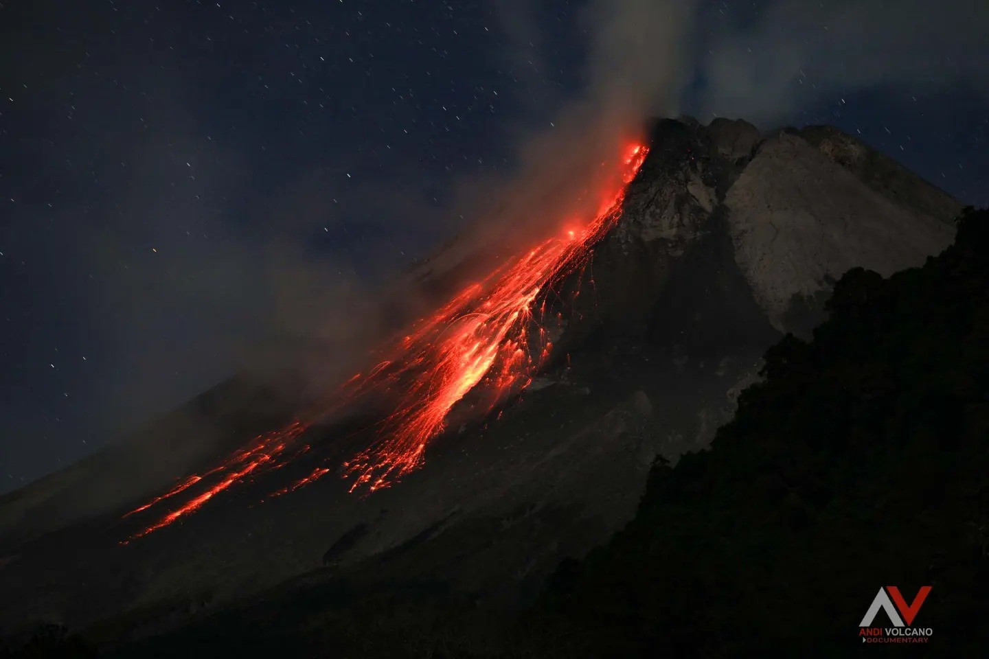
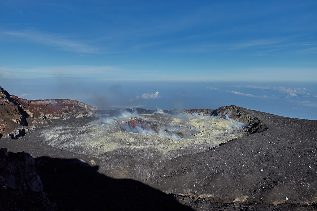
Report on the activity of Mount Merapi from October 13, 2023 to October 19, Published on October 20, 2023.
OBSERVATION RESULTS
Visual
The weather around Mount Merapi is generally sunny in the morning and afternoon, while the evening is foggy. White smoke, fine to thick, low to medium pressure and 200 m high was observed from the observation post of Mount Merapi in Badaban on October 16, 2023 at 6:30 a.m.
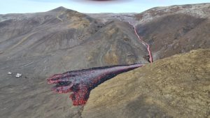
This week, lava avalanches were observed 207 times towards the South and South-West, including 54 times upstream of the Boyong River up to 1600 m, 151 times upstream of the Bebeng River up to a maximum of 1800 m, 1 time upstream of the Sat/Putih river up to a maximum of 1500 m and 1 time upstream of the Senowo river up to a maximum of 800 m. The sound of avalanches was heard 24 times from the Babadan post with low to moderate intensity.
Based on the analysis of aerial photos from September 28, 2023, the volume of the southwest dome was measured at 3,097,700 cubic meters and that of the central dome at 2,358,500 cubic meters.
Seismicity
This week, the seismicity of Mount Merapi showed:
1 shallow volcanic earthquakes (VTB),
2172 multi-phase (MP) earthquakes,
830 avalanche earthquakes (RF)
5 tectonic earthquakes (TT).
1 low frequency earthquakes (LF).
The intensity of seismicity this week is lower than last week, but the number of earthquakes is still quite high.
Deformation
The deformation of Mount Merapi that was monitored using EDM this week showed a shortening of steepening distance of 0.2 cm/day.
Rain and lahars:
There was no rain this week at Pengamatan’s Mount Merapi lookout post. There have been no reports of additional flows or lahars from rivers flowing down from Mount Merapi.
Conclusion
Based on the results of visual and instrumental observations, it is concluded that:
-Mount Merapi’s volcanic activity is still quite high in the form of effusive eruption activity. The activity status is defined at the “SIAGA” level.
The current danger potential is in the form of lava avalanches and hot clouds in the South-South-West sector including the Boyong river for a maximum of 5 km, the Bedog, Krasak, Bebeng rivers for a maximum of 7 km. In the South-East sector, it includes the Woro river for a maximum of 3 km and the Gendol river for 5 km. While the ejection of volcanic material in the event of an explosive eruption can reach a radius of 3 km from the summit.
Source : BPPTKG
Photo : Andi volcanist
Kamchatka , Klyuchevskoy :
56.06 N, 160.64 E;
Elevation 4750 m (15580 ft)
Aviation Colour Code is ORANGE
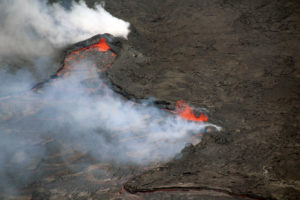
The summit explosive-effusive eruption of the volcano continues. Ash explosions up to 7-8 km (23,000-26,200 ft) a.s.l. could occur at any time. Ongoing activity could affect international and low-flying aircraft.
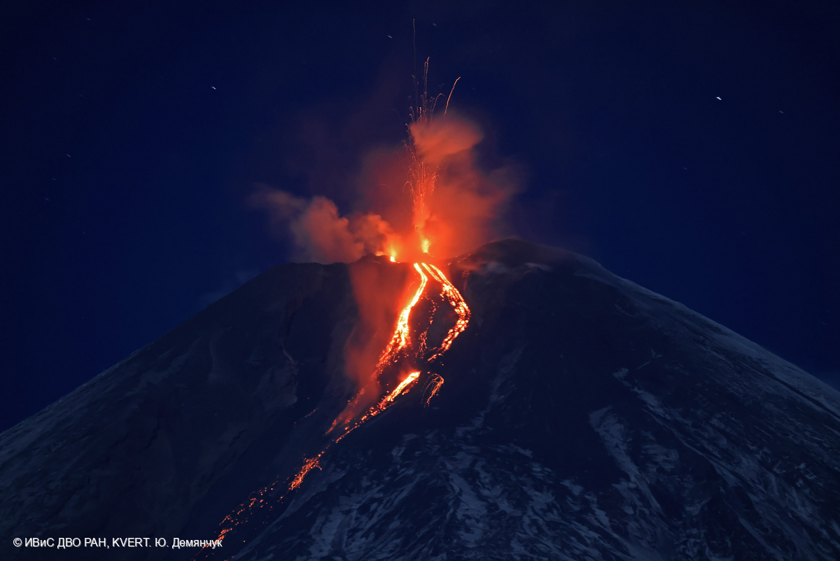
The summit explosive-effusive eruption of the volcano continues. Against the background of explosive activity of the Strombolian type (lava fountaining in the volcanic crater), the lava flows continue to effuse along the Apakhonchichsky and Kozyrevsky (from 17 October) chutes on the southern slopes of the volcano. Satellite data by KVERT showed a large thermal anomaly over the volcano all week: ash plumes, containing mainly old ash from pyroclastic collapses from the sides of the Apakhonchich chute, were raising up to 6 km a.s.l., and extended for 430 km to the eastern directions of the volcano.
Source : Kvert.
Photo : Yu. Demyanchuk. IVS FEB RAS, KVERT
Chile , Laguna del Maule :
Seismology
The seismological activity of the period was characterized by the recording of:
1136 seismic events of type VT, associated with the fracturing of rocks (Volcano-Tectonics). The most energetic earthquake had a Local Magnitude (ML) value equal to 1.8, located 3.5 km east-southeast of the center of the lagoon, at a depth of 7.8 km compared to the average height of the lagoon.
3 LP type seismic events, associated with fluid dynamics inside the volcanic system (Long Period). The size of the largest earthquake evaluated from the Reduced Displacement (RD) parameter was equal to 20 cm2.
3 HB type seismic events, associated with both rock fracturing and fluid dynamics within the volcanic system (Hybrid). The most energetic earthquake had a reduced displacement (DR) value of 200 cm2 and a local magnitude (ML) value equal to 3.1, located 1.6 km south-southeast of the Barrancas volcanic complex, at a depth of 3.7 km in reference to the crater.
Fluid geochemistry
No anomalies have been reported in emissions of sulfur dioxide (SO2) into the atmosphere in the area near the volcanic complex, according to data published by TROPOMI and the Ozone Monitoring Instrument (OMI).
Geodesy
From the 2 continuous GNSS stations operating in the volcanic complex, we observe that the inflationary process continues. The relative vertical deformation rate between the two stations for this period is 0.9 cm/month, lower than that of the previous period, but it is considered high.
In comparison, the average relative increase for the whole of 2023 is 0.6 cm/month.
Thanks to satellite radar interferometry, no signal associated with deformation due to the heavy presence of snow in the area was detected.
During the period assessed, the system continues to produce recurring volcanic seismic activity from two main sources. The first is located in the South-West sector with earthquakes linked to brittle rupture processes (Type VT), whose magnitudes are generally moderate to low, and which on certain occasions temporarily increase their occurrence. In the second source located near the “Barrancas” volcanic center, hybrid type energetic earthquakes linked to mixed processes (combination of processes linked to fluids and ruptures of fragile materials) were recorded. At the same time, the process of cortical deformation remains active with uplift rates within the historically recorded average. From the above, it is deduced that the volcanic system continues to record symptoms of internal activity, showing that it is still above its base threshold, therefore, its technical alert is maintained at:
YELLOW TECHNICAL ALERT: Changes in the behavior of volcanic activity
Source : Sernageomin.
Photo : Franco Vera.
Alaska , Trident :
58°14’3″ N 155°6’9″ W,
Summit Elevation 3599 ft (1097 m)
Current Volcano Alert Level: ADVISORY
Current Aviation Color Code: YELLOW
Earthquake activity continued this past week but at lower levels than previous weeks, with 23 earthquakes located in the vicinity of Trident, and 66 located within the broader Katmai group of volcanoes. The largest event in the area was a M2.3 quake located about 0.6 miles (1 km) SW of nearby Mageik on Thursday, October 19. During the past two weeks, the number of deeper earthquakes under Trident has tapered off, with only one event on October 13 located at 18 miles (29 km) below sea level. This may suggest that deeper movement of fluids and/or magma is diminishing.
This week, satellite and web camera data showed no significant volcanic activity.
Aerial view of Trident volcano from the southwest.
The current period of unrest began in August 2022. Since then, most earthquakes have occurred within the shallow crust, with depths less than 4 miles (6 km) below sea level; however, deeper quakes (greater than 9 miles or 15 km depth) were notable during much of the unrest period. Surface uplift, low-frequency earthquakes, and seismic tremor – all consistent with magmatic activity – have been observed over this extended period as well.
Increases in seismic activity have been detected previously at Trident Volcano and other similar volcanoes and did not result in eruptions. We expect additional shallow seismicity and other signs of unrest, such as gas emissions, elevated surface temperatures, and ground movement, to precede any future eruption if one were to occur.
Trident Volcano is monitored by local seismic sensors, web cameras, regional infrasound and lightning networks, and satellite data.
Source : AVO.
Photo : Lopez, Taryn
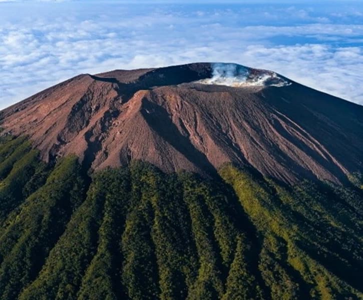
Indonesia , Slamet :
PRESS RELEASE: Increase in the activity level of G. Slamet from level I (normal) to level II (WASPADA)
The Slamet Volcano (G. Slamet) is a cone-shaped stratovolcano rising to an altitude of 3,432 meters. The activity level of G. Slamet has been level I (Normal) since October 9, 2020.
Visual observation
During the period October 1-18, 2023, Mount Slamet was clearly observed, sometimes covered in fog, when clear, white smoke from the main crater was observed with fine, medium to thick intensity, about 50 to 300 meters above the summit.
Instrumental observation
Earthquakes recorded between October 1 and 18, 2023:
2096 emissions earthquakes,
3 harmonic tremors,
2 deep volcanic earthquakes,
12 local tectonic earthquakes,
7 distant tectonic earthquakes
continuous tremor with an amplitude of 0.2 to 6 mm (dominant value 2 mm).
On October 1, 2023, an increase in the amplitude of the continuous tremor was recorded from 2 mm to 3 mm, then on October 18, 2023, a harmonic tremor event was recorded with a maximum duration of approximately 1 hour 18 minutes .
Deformation monitoring by EDM (Electronic Distance Measurement) showed that inflation was detected at Cilik station, but Buncis station tended to be oriented downward and Jurangmangu station, located below Cilik station, did not show a significant deformation pattern. The pressure is estimated to have passed through Buncis and Jurangmangu stations and towards Cilik station.
Monitoring of deformations using an inclinometer at the Cilik station at an altitude of 1,500 m above sea level showed that there was inflation (increase in pressure) on the axis radial of 30 microradians since July 2023. Additionally, the inflation pattern has started to be detected at the Bambangan Inclinometer Station. at an altitude of 2000 meters above sea level from October 11, 2023 to October 18, 2023 by 40 microradians.
Hot spring temperature measurements (MAP) at 3 (three) locations show that temperature values in Sicaya fluctuate in the range of 54 to 60 °C, and currently there is a trend towards a decrease in spring temperature hot. The temperature in Pengasihan fluctuates between 47 and 53°C, while in Pandansari it fluctuates between 40 and 47°C and is currently trending upward.
Assessment and potential hazards
The Mount Slamet tremor in October 2023 was marked by an increase in the amplitude of continuous tremors followed by the recording of a long-lasting harmonic tremor. The increase in the amplitude of continuous tremors indicates an increase in groundwater heating in the body of Mount Slamet at shallow depths, while the record of long-duration earthquakes and harmonic tremors shows an increase in emissions over Mount Slamet.
Deformation measurements showed an increase in pressure on the Slamet. With the inflation at the Bambangan inclinometer station, which is the inclinometer station closest to the summit, this shows that the pressure has shifted towards the summit of Mt. Slamet or is at a shallower depth than before.
This shows that there is an increase in pressure under the body of G. Slamet which can trigger shallow earthquakes and phreatic eruptions.
The current potential threat to Mount Slamet is phreatic or magmatic eruptions which can produce ejections of incandescent material that strike the area around the summit within a 2 km radius. Ash showers may occur around the crater or hit areas determined by wind direction and speed.
Source : PVMBG.
Photos : Istimewa/Instagram @indrasutantoo , Vinchel Budihardjo.