June 09 , 2023.
Hawaii , Kilauea :
Thursday, June 8, 2023, 9:39 AM HST (Thursday, June 8, 2023, 19:39 UTC)
19°25’16 » N 155°17’13 » W,
Summit Elevation 4091 ft (1247 m)
Current Volcano Alert Level: WATCH
Current Aviation Color Code: ORANGE
Activity Summary:
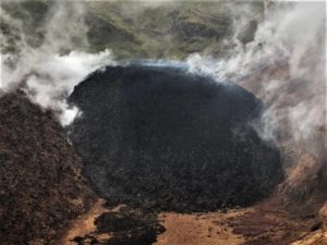
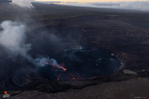
Kīlauea volcano is erupting. Eruptive activity is currently confined to Halemaʻumaʻu crater within Kīlauea’s summit caldera. No unusual activity has been noted along Kīlauea’s East Rift Zone or Southwest Rift Zone.
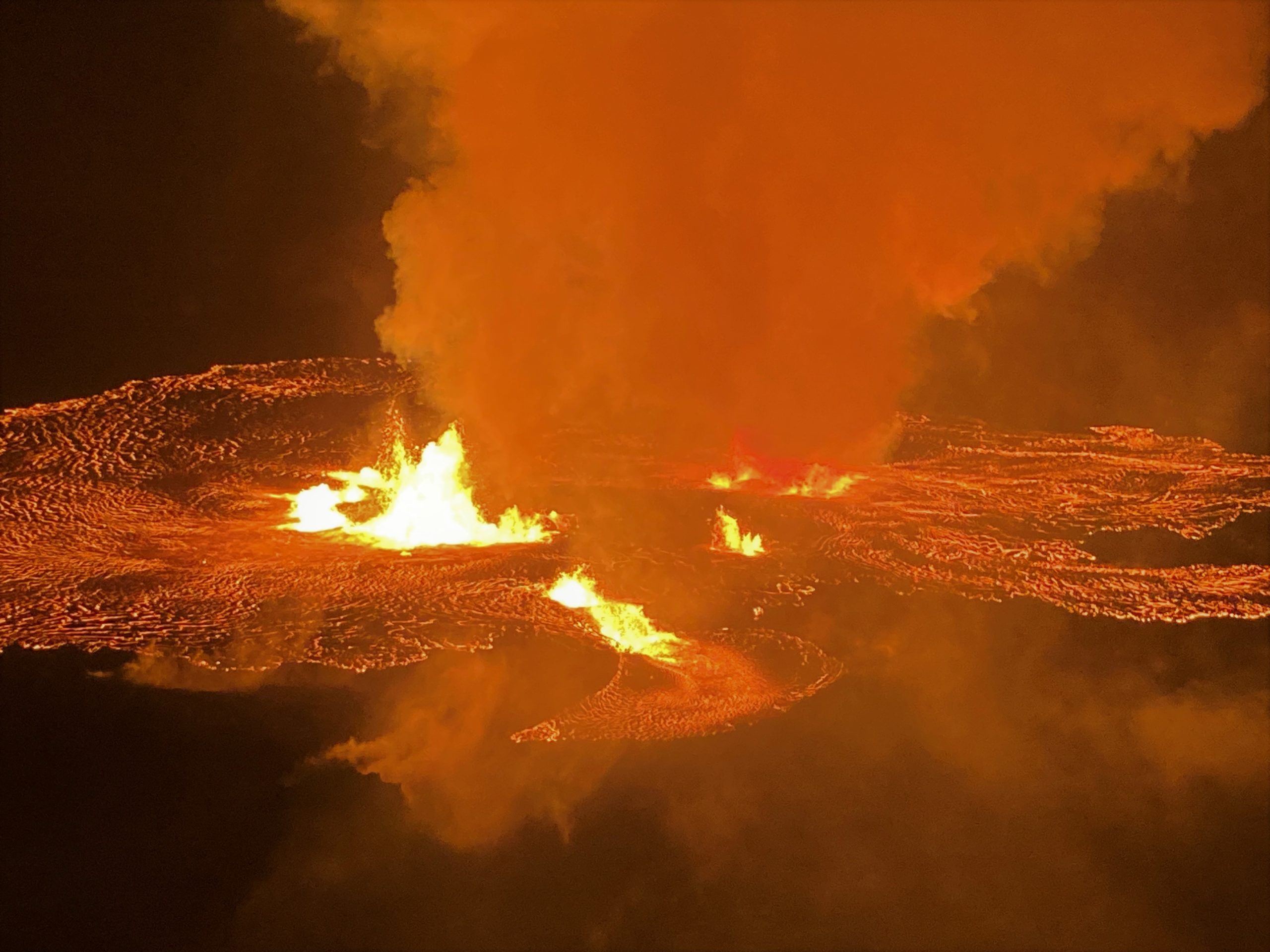
Halemaʻumaʻu Lava Lake Observations:
Multiple minor fountains remain active in the central eastern portion of Halema‘uma‘u crater floor and one vent is open above the crater floor on the west wall of the caldera. Lava fountain heights have decreased since the eruption onset, but remain up to about 10 meters (33 feet) high. Active lava covers much of the crater floor (an area of approximately 1.5 square km or 370 acres). After an initial rise of approximately 6 meters (20 feet) depth of new lava added to the crater floor (measured by laser range finder), the lava level has decreased over the past day by 2 meters (6 feet), likely due to gas loss. This drop left a « bathtub ring » of cooled lava along the cliffs at the edge of the crater floor. An average effusion rate of approximately 150 cubic meters per second is estimated for initial 24 hours, based on the rise in the lava lake level and assuming a flat surface; however, this estimate is likely inflated and doesn’t account for vesiculated lava and variations in topography across the surface of the crater floor. The very earliest phases of this eruption appears to have an effusion rate that was significantly higher than the previous three Kīlauea summit eruptions based upon the rapid coverage of the entire crater floor. The effusion rate has since declined and a refined estimate will be provided when overflight data is reduced.
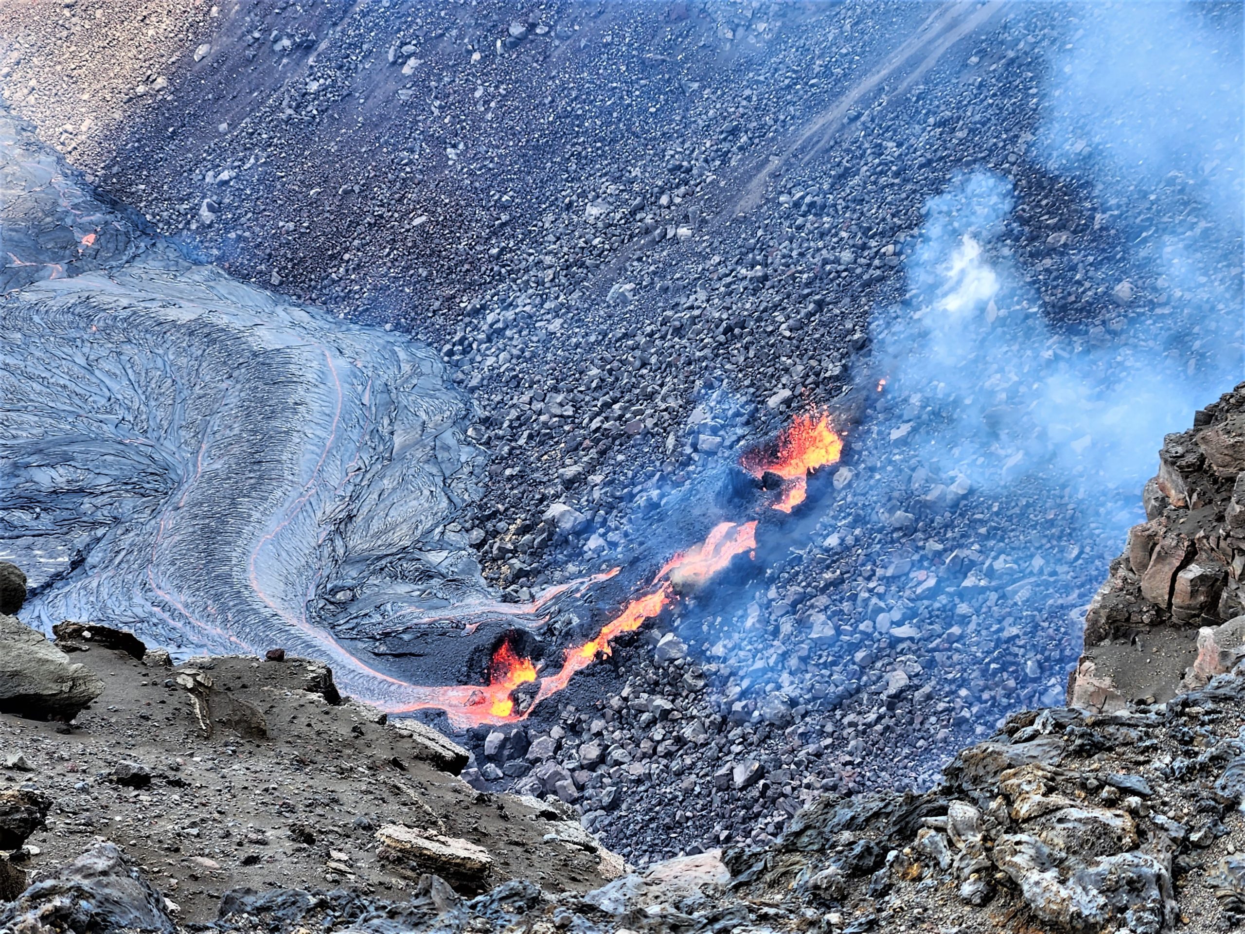
Lava fountaining from a fissure that cut across the southwest wall of Halema‘uma‘u on June 7, 2023, had built up a small cone structure by mid-day. The fissure was intermittently obscured by plumes of volcanic gases throughout the day.
Summit Observations:
Summit tilt has remained deflationary over the past 24 hours. Summit seismic activity is dominated by eruptive tremor (a signal associated with fluid movement) resumed. Volcanic gas emissions in the eruption area are elevated; a sulfur dioxide (SO2) emission rate of approximately 65,000 tonnes per day was measured yesterday, June 7, 2023.
Rift Zone Observations:
No unusual activity has been noted along the East Rift Zone or Southwest Rift Zone; low rates of deflationary ground deformation and seismicity continue along the East Rift Zone. Measurements from continuous gas monitoring stations in the middle East Rift Zone—the site of 1983–2018 eruptive activity—remain below detection limits for SO2.
Source : HVO
Photos : USGS , USGS / K. Lynn.
Indonesia , Anak Krakatau :
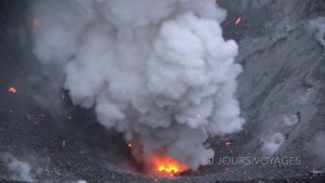
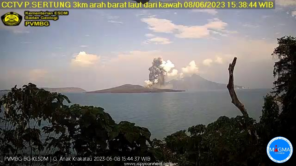
An eruption of Mount Anak Krakatau occurred on Thursday, June 08, 2023 at 3:37 p.m. WIB with the height of the ash column observed at ± 1000 m above the peak (± 1157 m above sea level). The ash column was observed to be grey/black with a thick intensity, oriented to the South-West. This eruption was recorded on a seismograph with a maximum amplitude of 60 mm and a duration of 335 seconds.
VOLCANO OBSERVATORY NOTICE FOR AVIATION – VONA
Issued : June 08 , 2023
Volcano : Anak Krakatau (262000)
Current Aviation Colour Code : ORANGE
Previous Aviation Colour Code : orange
Source : Anak Krakatau Volcano Observatory
Notice Number : 2023KRA054
Volcano Location : S 06 deg 06 min 07 sec E 105 deg 25 min 23 sec
Area : Lampung, Indonesia
Summit Elevation : 502 FT (157 M)
Volcanic Activity Summary :
Eruption with volcanic ash cloud at 08h37 UTC (15h37 local).
Volcanic Cloud Height :
Best estimate of ash-cloud top is around 3702 FT (1157 M) above sea level or 3200 FT (1000 M) above summit. May be higher than what can be observed clearly. Source of height data: ground observer.
Other Volcanic Cloud Information :
Ash cloud moving to southwest. Volcanic ash is observed to be gray to dark. The intensity of volcanic ash is observed to be thick.
Remarks :
Eruption recorded on seismogram with maximum amplitude 60 mm and maximum duration 335 second.
Source et photo : Magma Indonésie.
Philippines , Mayon :
MAYON VOLCANO BULLETIN 09 June 2023 8:00 AM
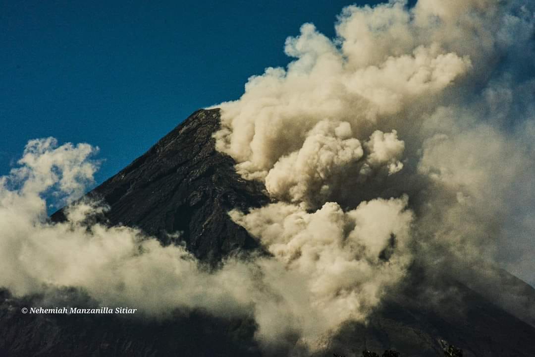
In the past 24-hour period, the Mayon Volcano Network recorded six (6) dome-collapse Pyroclastic Density Currents (PDC) that lasted three (3) to six (6) minutes and one hundred ninety-nine (199) rockfall events based on seismic and visual observations. The PDC and rockfall events emplaced lava debris on the southern gullies within two kilometers from the summit crater. Thin light brown ash from the rockfalls and continuous moderate degassing from the summit crater produced steam-laden plumes that were bent and drifted to the general south. Fair crater glow or “banaag” and incandescent rockfall shed from new fluidal lava at the summit of Mayon Volcano were also observed last night. Sulfur dioxide (SO2) emission was last measured at an average of 332 tonnes/day on 07 June 2023. Short-term observations from EDM and electronic tiltmeter monitoring show the upper slopes to be inflating since February 2023. Longer-term ground deformation parameters based on EDM, precise leveling, continuous GPS, and electronic tilt monitoring indicate that Mayon is still inflated, especially on the northwest and southeast.
Alert Level 3 is now raised over Mayon Volcano, which means that it is currently in a relatively high level of unrest as magma is at the crater and hazardous eruption is possible within weeks or even days. It is therefore recommended that the 6-km radius Permanent Danger Zone (PDZ) be evacuated due to the danger of PDCs, lava flows, rockfalls and other volcanic hazards. Increased vigilance against pyroclastic density currents, lahars and sediment-laden streamflows along channels draining the edifice is also advised. Heavy rainfall could generate channel-confined lahars and sediment-laden streamflows in channels where PDC deposits were emplaced. Civil aviation authorities must also advise pilots to avoid flying close to the volcano’s summit as ash from any sudden eruption can be hazardous to aircraft. Based on the current prevailing wind pattern, ash fall events may most likely occur on the south side of the volcano. DOST-PHIVOLCS maintains close monitoring of Mayon Volcano and any new development will be communicated to all concerned stakeholders.
Source : Phivolcs
Photo : Nehemiah Manzanilla Sitiar.
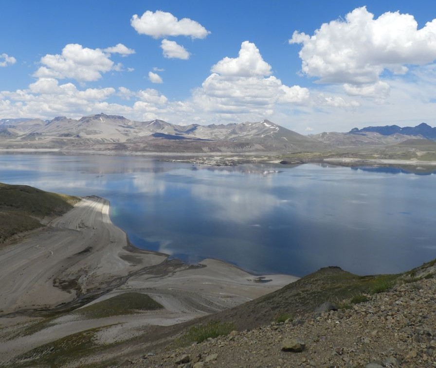
Chile , Laguna del Maule :
Seismology
The seismological activity of the period was characterized by the recording of:
1,157 VT-type seismic events, associated with rock fracturing (Volcano-Tectonics). The most energetic earthquake presented a value of Local Magnitude (ML) equal to 1.6, located 7.4 km south-south-west of the center of the lagoon, at a depth of 6 km compared to the height average of the lagoon.
5 LP-type seismic events, associated with fluid dynamics within the volcanic system (Long Period). The size of the largest earthquake assessed from the Reduced Displacement (DR) parameter was equal to 4 cm2.
1 TR type seismic event, associated with the dynamics maintained over time of the fluids within the volcanic system (TRemor). The earthquake size estimated from the Reduced Displacement (DR) parameter was equal to 16 cm2.
1 HB-type seismic event, associated with both rock fracturing and fluid dynamics within the volcanic system (Hybrid). The earthquake size estimated from the Reduced Displacement (DR) parameter was equal to 5.6 cm2. No event presented enough energy to be localized.
Fluid Geochemistry
No anomaly of sulfur dioxide (SO2) emissions in the atmosphere has been reported in the area close to the volcanic complex, according to data published by the Tropospheric Monitoring Instrument (TROPOMI) and the Ozone Monitoring Instrument (OMI) .
Geodesy
The geodetic activity of the period was characterized by:
– Monitoring lines in averages very similar to the historical values observed in the volcanic complex, adjusting a maximum of 1.60 cm / month.
– Decrease in the vertical rate of the NIEB station, which for the previous period adjusted a rate of 2.20 cm/month and presents in May a maximum rate of 1.36 cm/month.
– Horizontal strain rates similar to previous periods, with some minor variations.
Due to the above, it is concluded that the historically observed inflationary process in the complex continues in values adjusted to the usual averages.
The VT-type recurrent seismicity record remains, although with comparatively lower occurrence rates than those recorded in previous months. A new seismic swarm was recorded on May 29, indicating the continuation of the anomalous process reported during this year.
The crustal inflation process continues, where the highest vertical uplift rates continue to be recorded by the station located in the center of the lagoon (MAU2). Superficially, no relevant change is detected. This activity shows that the volcanic complex is still above its base threshold, therefore, its technical alert remains yellow and a potential assignment radius of 2 km is considered from the CO2 anomaly zone.
YELLOW TECHNICAL ALERT: Changes in behavior of volcanic activity.
Source : Sernageomin.
Photo : Cegemar.
Ecuador , Sangay :
DAILY REPORT OF THE STATE OF SANGAY VOLCANO, Thursday June 08, 2023.
Information Geophysical Institute – EPN.
Surface Activity Level: High, Surface Trend: Ascending
Internal activity level: High, Internal trend: No change
Seismicity: From June 07, 2023, 11:00 a.m. to June 08, 2023, 11:00 a.m.:
Below is the count of seismic events recorded by the SAG1 station over the past 24 hours.
Explosion Event (EXP):576
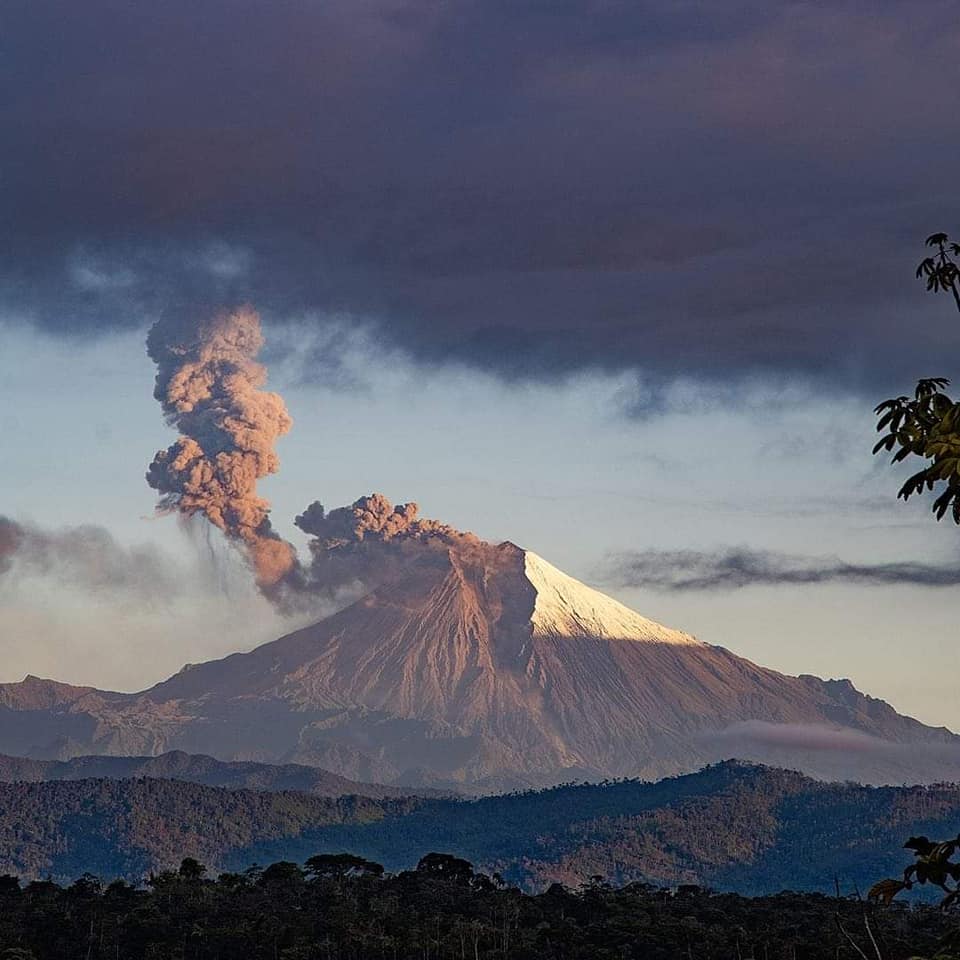
Rains / Lahars:
Rains were recorded yesterday afternoon in the volcano area, so far there are no reports of lahars. “In the event of heavy rains, these could remobilize the accumulated materials, generating mudslides and debris that would descend the flanks of the volcano and flow into the adjacent rivers, in particular the Volcán and Upano rivers”
Emission / Ash Column:
No ash emission was observed due to the cloudiness of the volcano. The Washington VAAC agency did not issue ash emission alerts.
Gas:
The MOUNTS system detected 275.6 tonnes of sulfur dioxide (SO2), measured on 06/07/2023 at 13:48TL.
Other Monitoring Parameters:
FIRMS (MODIS) 6 thermal anomalies have been recorded in the last 24 hours.
Observation:
During the night, incandescent materials were observed in the crater.
Alert level: Orange.
Source : IGEPN.
Photo : volcan sangay