March 27 , 2022.
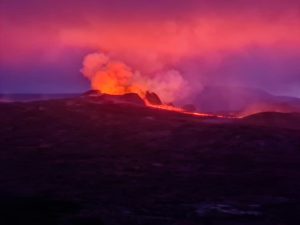
Philippines , Taal :
TAAL VOLCANO BULLETIN 27 March 2022 8:00 AM
After the phreatomagmatic eruption of the Main Crater at 07:22 AM to 08:59 AM yesterday (26 March 2022), two (2) subsequent phreatomagmatic events at 4:34 AM and 5:04 AM today have been recorded by the Taal Volcano Network or TVN based on seismic records and visual cameras. These events produced 800 meter- and 400-meter-tall plumes, respectively, from the Main Crater that drifted southwest.
In the past 24-hour period, the TVN recorded fourteen (14) volcanic earthquakes, including ten (10) volcanic tremor events having durations of two (2) to three (3) minutes, and four (4) low-frequency volcanic earthquakes. Activity at the Main Crater was dominated by upwelling of hot volcanic fluids in its lake which generated plumes 1,000 meters tall that drifted southwest. Sulfur dioxide (SO2) emission averaged 6,957 tonnes/day on 25 March 2022. Temperature highs of 63.7°C were last measured from the Main Crater Lake on 25 February 2022
The Alert Level 3 (Magmatic Unrest) prevails over Taal Volcano. This means that there is a magmatic intrusion at the Main Crater that may further drive succeeding eruptions. DOST-PHIVOLCS strongly recommends Taal Volcano Island and high-risk barangays of Bilibinwang and Banyaga, Agoncillo and Boso-boso, Gulod and eastern Bugaan East, Laurel, Batangas Province be evacuated due to the possible hazards of pyroclastic density currents and volcanic tsunami should stronger eruptions subsequently occur. The public is reminded that the entire Taal Volcano Island is a Permanent Danger Zone (PDZ), and entry into the island as well as high-risk barangays of Agoncillo and Laurel must be prohibited. All activities on Taal Lake should not be allowed at this time. Communities around the Taal Lake shores are advised to remain vigilant, take precautionary measures against possible airborne ash and vog and calmly prepare for possible evacuation should unrest intensify. Civil aviation authorities must advise pilots to avoid flying over Taal Volcano Island as airborne ash and ballistic fragments from sudden explosions and pyroclastic density currents such as base surges may pose hazards to aircraft. DOST-PHIVOLCS maintains its close monitoring of Taal Volcano and any new development will be communicated to all concerned stakeholders.
Source : Phivolcs
Photo : Amy Andal.
Hawaii , Kilauea :
19°25’16 » N 155°17’13 » W,
Summit Elevation 4091 ft (1247 m)
Current Volcano Alert Level: WATCH
Current Aviation Color Code: ORANGE
Activity Summary:
The summit eruption of Kīlauea Volcano, within Halemaʻumaʻu crater, continued over the past 24 hours. All recent activity has been confined to the crater, and there are no indications of activity migrating elsewhere on Kīlauea.
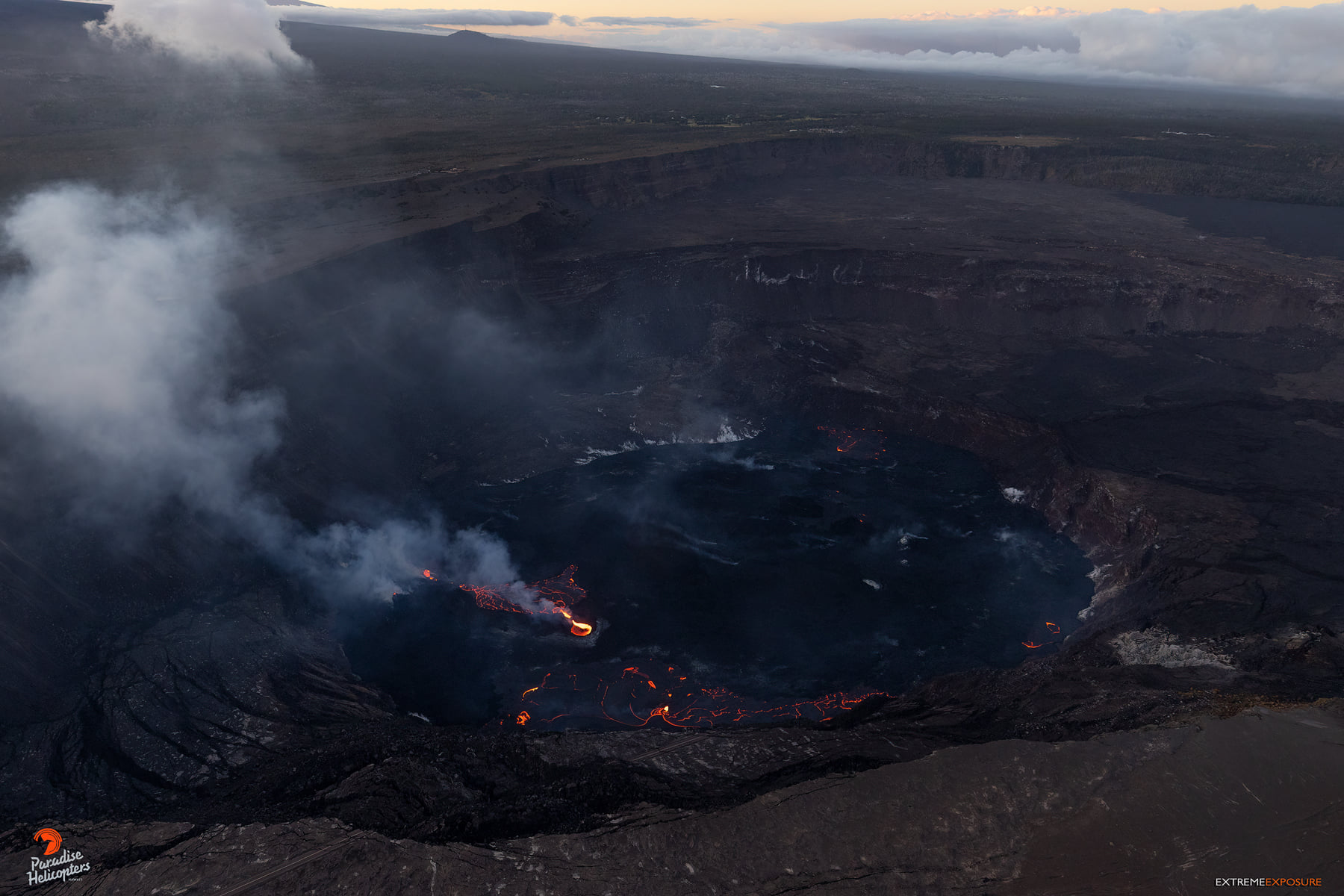
Halemaʻumaʻu Lava Lake Observations:
Eruption of lava from the western vent into the active lava lake (approximately 2.5% of the crater floor surface) and onto the crater floor continued over the past 24 hours. There were also numerous and sustained oozeouts along the margins of the crater floor, as well as vigorous overflows from the active lava lake onto the crater floor over the past 24. hours. Since the beginning of this eruption on September 29, 2021, the crater floor has seen a total rise of about 89 meters (292 feet). The volume of lava effused since the beginning of this eruption was approximately 58 million cubic meters (76 million cubic yards) as measured on March 17, 2022.
Summit Observations:
Summit tilt has transitioned to mild deflation following a period of inflation that began on March 23. Volcanic tremor remains above background levels. A sulfur dioxide (SO2) emission rate of approximately 1,400 tonnes per day (t/d) was measured on March 23.
Source : HVO.
Photo : Bruce Omori / Paradise Helicopters.
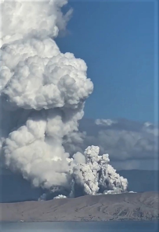
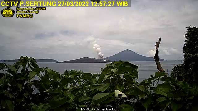
Indonesia , Anak Krakatau :
VOLCANO OBSERVATORY NOTICE FOR AVIATION – VONA.
Issued : March 26 , 2022
Volcano : Anak Krakatau (262000)
Current Aviation Colour Code : ORANGE
Previous Aviation Colour Code : orange
Source : Anak Krakatau Volcano Observatory
Notice Number : 2022KRA20
Volcano Location : S 06 deg 06 min 07 sec E 105 deg 25 min 23 sec
Area : Lampung, Indonesia
Summit Elevation : 502 FT (157 M)
Volcanic Activity Summary :
Eruption with ash clouds at 10:43 UTC (17:43 local time). The eruption lasted for 62 seconds.
Volcanic Cloud Height :
Best estimate of ash-cloud top is around 2102 FT (657 M) above sea level, may be higher than what can be observed clearly. Source of height data: ground observer.
Other Volcanic Cloud Information :
Visuals directly from the cctv were observed eruptions with the color of the thick grey eruption smoke 500m from the top of the volcano, the wind direction slowly to the southeast.
Remarks :
Eruption recorded on seismogram with maximum amplitude 50 mm and maximum duration 62 second.
Source : Magma Indonésie.
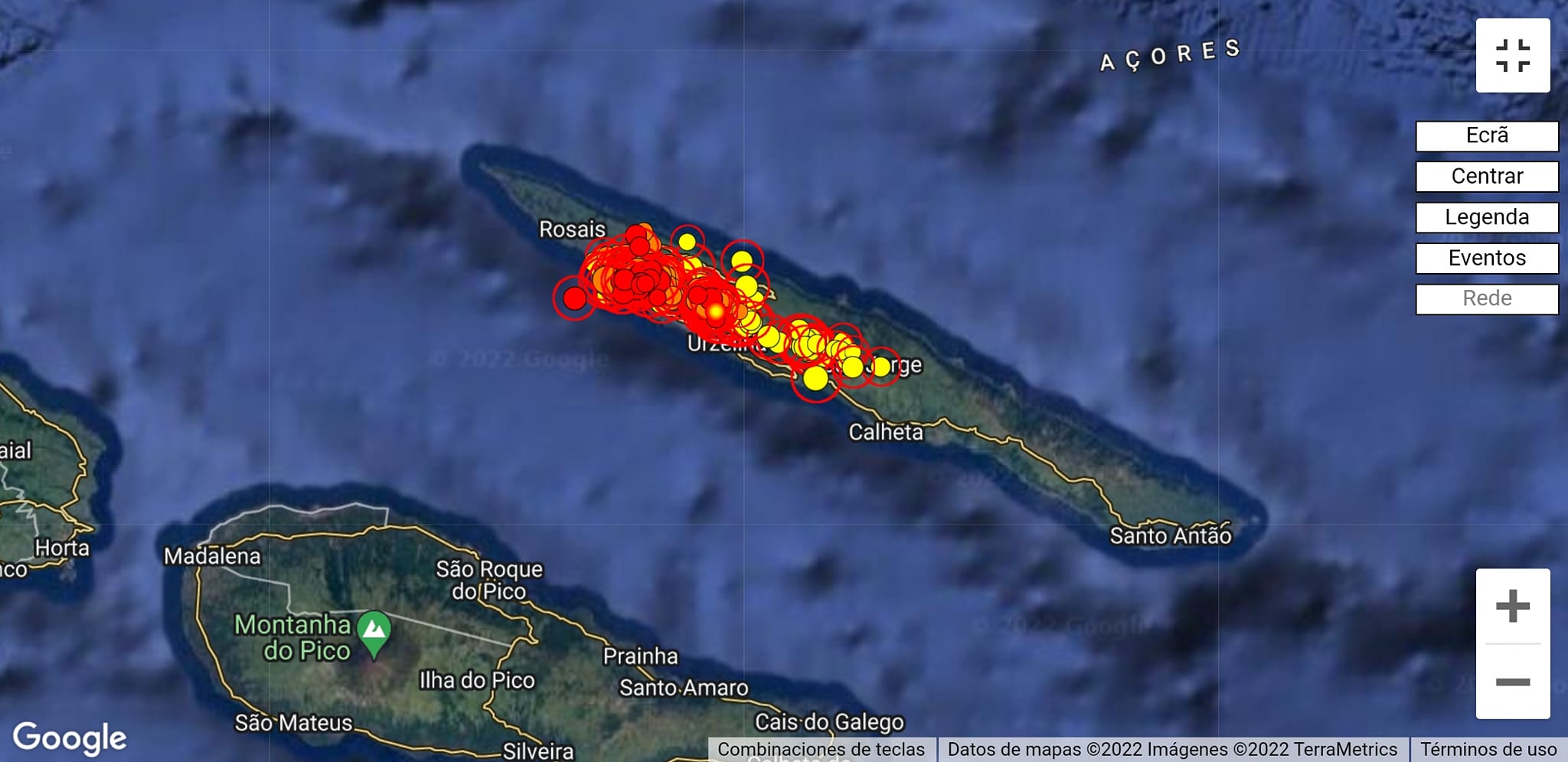
Azores , São Jorge :
Status update of March 26, 2022, 10:00 p.m.
The Azores Volcanic Earthquake Information and Monitoring Center (CIVISA) reports that the volcanic seismic crisis that has lasted since 4:05 p.m. (local time = UTC-1) on March 19 in the central part of the island of São Jorge , specifically along a strip with the WNW-ESE direction, in a sector between Velas and Fajã do Ouvidor, remains above the reference values.
The most energetic earthquake of this crisis occurred on March 19, at 6:41 p.m. (local time = UTC-1), had an epicenter about 2 km (2 km) from Urzelina and a magnitude of 3.3 (Richter). So far, about 190 earthquakes felt by the population have been identified.
Throughout the day of March 25, the preliminary analysis of the seismic recordings made it possible to count approximately 870 events. Between 12:00 a.m. and 10:00 p.m. today, about 870 events were counted, reflecting a slight decrease in seismic activity. All the earthquakes recorded so far are of low magnitude and show an origin of a tectonic nature.
The soil gas and temperature measurement campaign that CIVISA has been developing since the beginning of this crisis in the epicentral area has not resulted, to date, in the identification of any anomaly, continuing the investigations of ground in progress in the next few days.
Within the framework of geodetic monitoring, CIVISA, in collaboration with other entities, strengthens the GNSS observation network and processes satellite images. The existing data to date corroborate the seismological observations by informing of the existence of a certain deformation in the epicentral zone.
The integration of the available information allows to conclude that the tectonic structures where the historical eruptions of 1580 and 1808 developed, and the volcanic seismic crisis of 1964, in the volcanic system of fissures, have been reactivated, allowing to admit the appearance of a deep magmatic intrusion.
CIVISA warns of the possibility of earthquakes that could reach magnitudes greater than those recorded so far, as well as the danger of collapses reinforced by seismic activity. There is a real possibility that a volcanic eruption could occur, but there is no evidence that it is imminent.
For the above, CIVISA has been on ALERT V4 since 3:30 p.m. on March 20.
CIVISA has also issued an alert for the Santa Maria Air Traffic Control Center (ACC Santa Maria), the Volcanic Ash Advisory Center (VAAC) in Toulouse and the Portuguese Institute of the Sea and Atmosphere (IPMA).
Source : ivar.azores.gov.pt , GEVolcans .
Photos : GEVolcans.
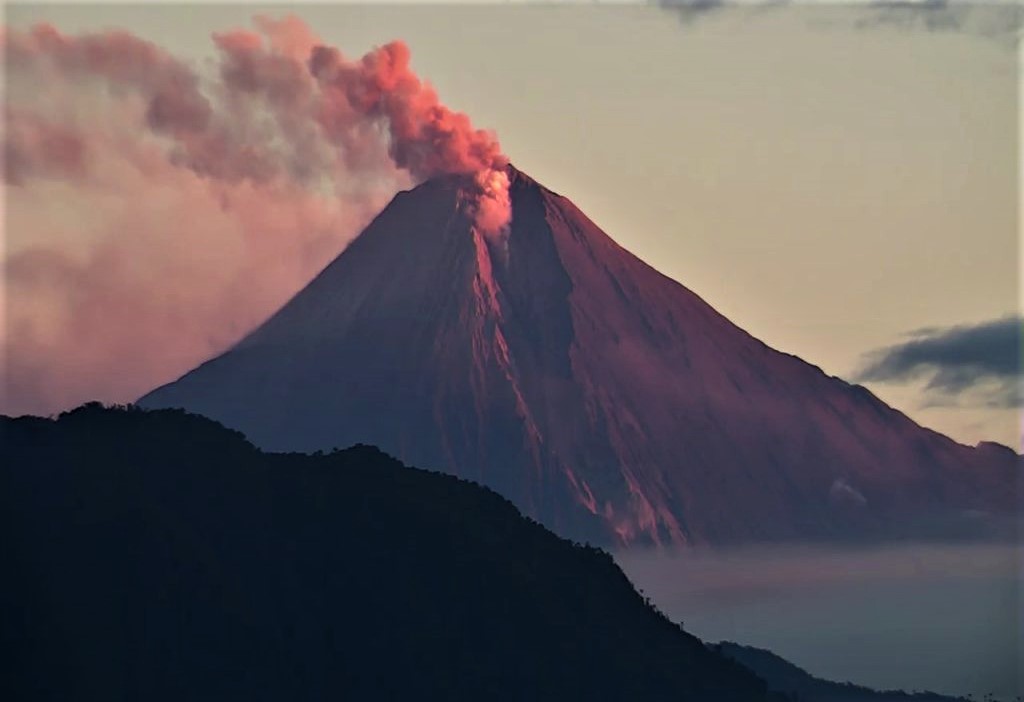
Ecuador , Sangay :
DAILY REPORT OF THE STATE OF SANGAY VOLCANO, Saturday March 26, 2022.
Information Geophysical Institute – EPN.
Surface Activity Level: High, Surface Trend: No change.
Internal activity level: High, Internal trend: No change.
Seismicity: From March 25, 2022, 11:00 a.m. to March 26, 2022, 11:00 a.m.:
Explosion (EXP) 8
Long Periods (LP) 24
Emission Tremors (TREMI) 25
Rains / Lahars:
Thanks to the Windy satellite system, the occurrence of rains in the volcano area has been recorded. **In the event of heavy rains, these could remobilize the accumulated materials, generating mudslides and debris that would descend on the flanks of the volcano and flow into the adjacent rivers.**
Emission / ash column:
The Washington VAAC reported ash emissions at 1,470 and 1,770 meters above the summit, trending west.
Gas:
The MOUNTS system recorded 714.3 tons of SO2 on 03/25/2022 at 2:20 p.m. TL
Other Monitoring Parameters:
MIROVA records 1 high thermal alert (223 MW) in the last 24 hours.
Observation:
Through photos shared by ECU-911, the sector is observed cloudy in the morning.
Alert level: Orange.
Source : IGEPN.
Photo : Webcam