April 22 , 2018.
Zheltovsky , Kamchatka :
VOLCANO OBSERVATORY NOTICE FOR AVIATION (VONA).
Issued: April 19 , 2018.
Volcano:Zheltovsky (CAVW #300040)
Current aviation colour code:RED
Previous aviation colour code:green
Source:KVERT
Notice Number:2018-0000
Volcano Location:N 51 deg 34 min E 157 deg 19 min
Area:Kamchatka, Russia
Summit Elevation:6307.44 ft (1923 m)
Volcanic Activity Summary:
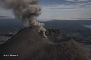
Very strong explosive eruption of Zheltovsky volcano began at 21:45 UTC on April 19, 2018. According to satellite data, ash is reaching 45,000 ft (13.8 km) a.s.l. and ash plume is drifting to the southeast of the volcano on the height 45,000 ft (13.8 km) a.s.l. at this time. Ash emission is continuing.
A strong explosive eruption of the volcano continues. Ongoing activity could affect international and low-flying aircraft.
Volcanic cloud height:
45264-45264 ft (13800-13800 m) AMSL Time and method of ash plume/cloud height determination: 20180419/2145Z – NOAA 18 (4m5)
Other volcanic cloud information:
Distance of ash plume/cloud of the volcano: 31 mi (50 km)
Direction of drift of ash plume/cloud of the volcano: ESE / azimuth 120 deg
Time and method of ash plume/cloud determination: 20180419/2145Z – NOAA 18 (4m5)
Start time of explosion and how determined: 20180419/2145Z – Satellite data
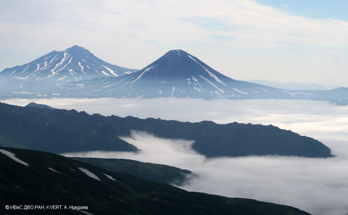
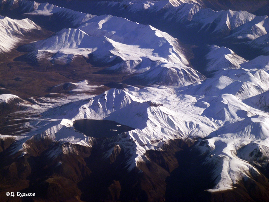
Ilinsky volcano (at centre) and Zheltovsky volcano (on the left) from the slope of Kambalny volcano.
Remarks:
This strong explosive eruption is extremely hazardous for aircraft downwind. There was one known a strong explosive eruption of Zheltovsky volcano on 11 February, 1923. Zheltovsky volcano is not monitored with a seismic station. KVERT uses satellite data and sometimes visual observations by hikers and pilots reports to monitor this volcano.
VOLCANO OBSERVATORY NOTICE FOR AVIATION (VONA)
Issued: April 20 , 2018.
Volcano:Zheltovsky (CAVW #300040)
Current aviation colour code:GREEN
Volcanic Activity Summary:
A moderate gas-steam activity of the volcano continues. KVERT continues to monitor Zheltovsky volcano.
Zheltovsky volcano was constructed during the last 8000 years within a 4 x 5 km caldera truncating an earlier Pleistocene edifice. A late-Holocene explosive eruption formed a 1.6-km-wide summit crater that was subsequently largely filled by four lava domes, the latest of which forms the present 1926-m-high summit. Several of the lava domes were emplaced along the buried SE rim of the summit crater. More than ten cinder cones and lava domes were constructed on the flanks, particularly on the NW side. Only a few eruptions are known in historical time. The largest, in 1923, produced explosive activity and a lava flow down the SE flank that also partly flowed into the summit crater.
Source : Kvert. GVP.
Photo : A. Nuzhdaev, IVS FEB RAS, KVERT ( 1/8/2017 )
Khangar , Kamchatka :
VOLCANO OBSERVATORY NOTICE FOR AVIATION (VONA).
Issued: April 19 , 2018.
Volcano:Khangar (CAVW #300272)
Current aviation colour code:RED
Previous aviation colour code:green
Source:KVERT
Notice Number:2018-0001
Volcano Location:N 54 deg 45 min E 157 deg 24 min
Area:Kamchatka, Russia
Summit Elevation:6560 ft (2000 m)
Volcanic Activity Summary:
A strong explosive eruption of Khangar volcano began at 22:15 UTC on April 19, 2018. According to satellite data, ash is reaching 25,000 ft (7.6 km) a.s.l. and ash plume is drifting to the northwest of the volcano on the height 25,000 ft (7.6 km) a.s.l. at this time. Ash emission is continuing.
A strong explosive eruption of the volcano continues. Ongoing activity could affect international and low-flying aircraft.
Volcanic cloud height:
24928-24928 ft (7600-7600 m) AMSL Time and method of ash plume/cloud height determination: 20180419/2215Z – NOAA 18 (4m5)
Other volcanic cloud information:
Distance of ash plume/cloud of the volcano: 19 mi (30 km)
Direction of drift of ash plume/cloud of the volcano: NW / azimuth 310 deg
Time and method of ash plume/cloud determination: 20180419/2215Z – NOAA 18 (4m5)
Start time of explosion and how determined: 20180419/2215Z – Satellite data
Remarks:
This strong explosive eruption is extremely hazardous for aircraft downwind. There are not known historical eruptions of Khangar. According to tephrachronological data, last explosive eruptions of this volcano occurred for about 4100, 2500, 1000 and 400 years ago. Khangar is not monitored with a seismic station. KVERT uses satellite data and sometimes visual observations by hikers and pilots reports to monitor this volcano.
VOLCANO OBSERVATORY NOTICE FOR AVIATION (VONA).
Issued: April 20 , 2018 .
Current aviation colour code: GREEN
Volcanic Activity Summary:
An activity of the volcano continues. KVERT continues to monitor Khangar volcano.
Khangar volcano, also spelled Hangar, is the southernmost volcano of the N-S-trending Sredinny Range, which stretches across western Kamchaktka. It is the dominant feature within a larger volcano-tectonic depression composed of two parts: a stratovolcano with a 2-km-wide Holocene caldera, and a large lava dome on its eastern flank. The steep-walled caldera, now filled by a lake, was formed during a major explosive eruption about 7000 years ago. An arcuate zone of pre-caldera flank lava domes nearly surrounds the volcano, and post-caldera domes form islands in the caldera lake. Late-stage olivine basalts were erupted along a NE-trending line in the southern part of the depression. The latest dated eruption took place about 500 years ago and marks the youngest known eruption from the Sredinny Range volcanoes.
Source : Kvert , GVP.
Photo : D. Bud’kov ( 2012 ) , http://www.photokamchatka.ru/photos/photo.php?ID=26453&sphrase_id=2552483
Dukono , Indonesia :
VOLCANO OBSERVATORY NOTICE FOR AVIATION – VONA.
Issued: April 21 , 2018.
Volcano: Dukono (268010)
Current Aviation Colour Code: ORANGE
Previous Aviation Colour Code: orange
Source: Dukono Volcano Observatory
Notice Number: 2018DUK46
Volcano Location: N 01 deg 41 min 35 sec E 127 deg 53 min 38 sec
Area: North Maluku, Indonesia
Summit Elevation: 3933 FT (1229 M)
Volcanic Activity Summary:
Eruption with volcanic ash cloud at 21h45 UTC (06h45 local).
Volcanic Cloud Height:
Best estimate of ash-cloud top is around 6173 FT (1929 M) above sea level, may be higher than what can be observed clearly. Source of height data: ground observer.
Other Volcanic Cloud Information:
Ash cloud moving to East.
Remarks:
Eruption and ash emission is continuing.
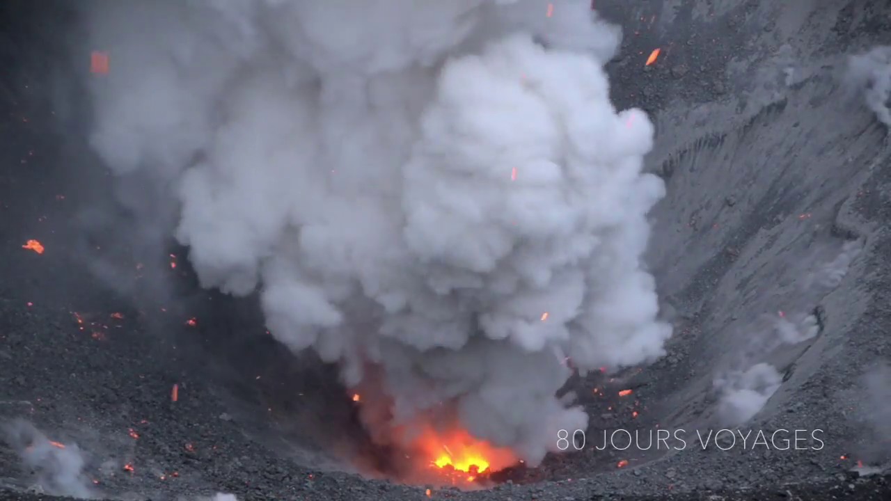
Activity Level at Level II (WASPADA). The Dukono (1229 m above sea level) has a continuous eruption.
Since yesterday until this morning, the volcano can be observed clearly until it is covered with fog. Crater smoke and eruptive ash are observed up to 600-700 m above the peak. The wind is blowing, weak to moderate, to the east. Since the PGA Dukono Post, the sound of the rash seemed weak during the night.
According to the seismograph dated April 21, 2018, it was recorded:
2 earthquakes of eruption.
4 distant tectonic earthquakes.
A continuous tremor associated with the ash eruption with an amplitude of 0.5-10 mm (dominant value 2 mm).
Recommendations:
Communities around G. Dukono and visitors / tourists should avoid activities, climbing and approaching the Malupang Warirang Crater within a radius of 2 km.
Source : Magma , VSI.
Photo : S Chermette ( 80joursvoyages.com/ ).
Kanlaon , Philippines :
KANLAON VOLCANO BULLETIN 22 April 2018 08:00 A.M.
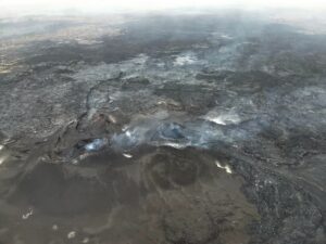
Kanlaon Volcano’s seismic monitoring network recorded two (2) volcanic earthquakes during the past 24 hours. Moderate emission of white steam-laden plumes that rose 300 meters from the summit before drifting southwest and northwest was observed. Ground deformation data from continuous GPS measurements indicate a more pronounced inflation of the edifice since December 2015, signifying pressurization deep beneath the edifice. Sulfur dioxide (SO2) emission was measured at an average of 798 tonnes/day on 20 April 2018.

Alert Level 2 status prevails over Kanlaon Volcano, which means that the volcano is undergoing a moderate level of unrest due to probable intrusion of magma at depth that may or may not lead to a magmatic eruption. The local government units and the public are strictly reminded that entry into the 4-kilometer radius Permanent Danger Zone (PDZ) is strictly prohibited due to the further possibilities of sudden and hazardous steam-driven or phreatic eruptions. Civil aviation authorities must also advise pilots to avoid flying close to the volcano’s summit as ejecta from any sudden phreatic eruption can be hazardous to aircraft.
DOST-PHIVOLCS is closely monitoring Kanlaon Volcano’s activity and any new development will be relayed to all concerned.
Source : Phivolcs.
Kilauea , Hawai :
19°25’16 » N 155°17’13 » W,
Summit Elevation 4091 ft (1247 m)
Current Volcano Alert Level: WATCH
Current Aviation Color Code: ORANGE
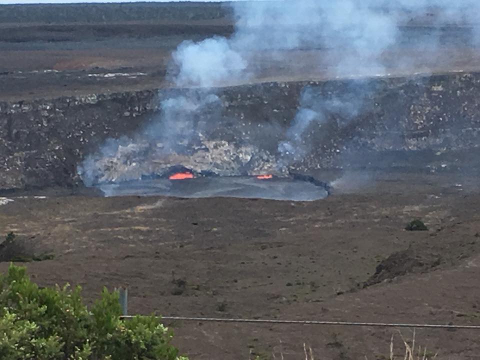
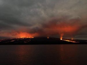
Halemaumau, the lava keeps rising, will it overflow ?? !!
Summit Observations:
Summit tiltmeters recorded inflationary tilt during the past day. When measured yesterday afternoon, the lava lake level was about 10 m (33 ft) below the rim of Overlook crater; the level had risen 4 meters (13 ft) from the previous day. The lava lake continued to rise overnight by a few meters (yards). Seismicity in the summit area is within normal, background rates, with tremor amplitude fluctuations associated with lava lake spattering and a few more small earthquakes in the upper East Rift Zone. Elevated summit sulfur dioxide emission rates persist.
Source : HVO.
Photo : David Ford.