June 08 , 2023.
Hawaii , Kilauea :
Alert Level: WARNING, Color Code: RED , June 07 , 2023 ,14:47:36 UTC. HVO/USGS Volcanic Activity Notice
Current Volcano Alert Level: WARNING
Previous Volcano Alert Level: WATCH
Current Aviation Color Code: RED
Previous Aviation Color Code: ORANGE
Issued: Wednesday, June 7, 2023, 4:47 AM HST
Source: Hawaiian Volcano Observatory
Notice Number: 2023/H159
Location: N 19 deg 25 min W 155 deg 17 min
Elevation: 4091 ft (1247 m)
Area: Hawaii
Volcanic Activity Summary:
Kīlauea volcano is erupting. At approximately 4:44 a.m. HST on June 7, 2023, the USGS Hawaiian Volcano Observatory detected glow in Kīlauea summit webcam images indicating that an eruption has commenced within Halemaʻumaʻu crater in Kīlauea’s summit caldera, within Hawai‘i Volcanoes National Park.
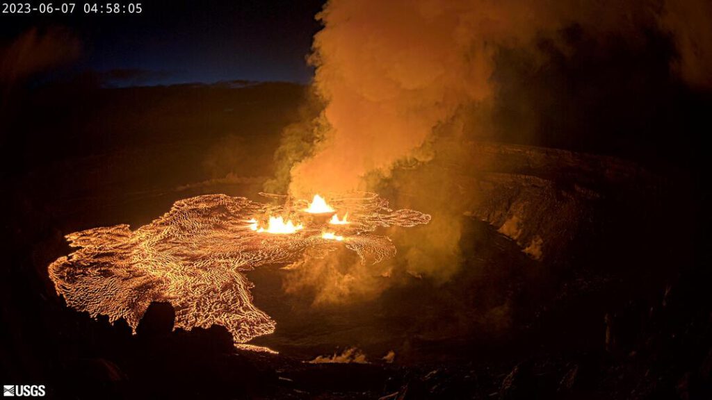
The USGS Hawaiian Volcano Observatory is elevating Kīlauea’s volcano alert level from WATCH to WARNING and its aviation color code from ORANGE to RED as this eruption and associated hazards are evaluated.
The opening phases of eruptions are dynamic. Webcam imagery shows fissures at the base of Halemaʻumaʻu crater generating lava flows on the surface of the crater floor. The activity is confined to Halemaʻumaʻu and the hazards will be reassessed as the eruption progresses.
HVO will continue to monitor this activity closely and report any significant changes in future notices.
HVO is in constant communication with Hawai‘i Volcanoes National Park as this situation evolves. The activity is confined entirely within the park.
Wednesday, June 7, 2023, 4:00 PM HST (Thursday, June 8, 2023, 02:00 UTC)
19°25’16 » N 155°17’13 » W,
Summit Elevation 4091 ft (1247 m)
Current Volcano Alert Level: WARNING
Current Aviation Color Code: RED
The summit eruption of Kīlauea that began within Halemaʻumaʻu crater at 4:44 a.m. HST today, June 7, 2023, continues at this time. All activity is confined to Kīlauea summit region, within Hawai‘i Volcanoes National Park. There are no indications of activity migrating out of the summit region.
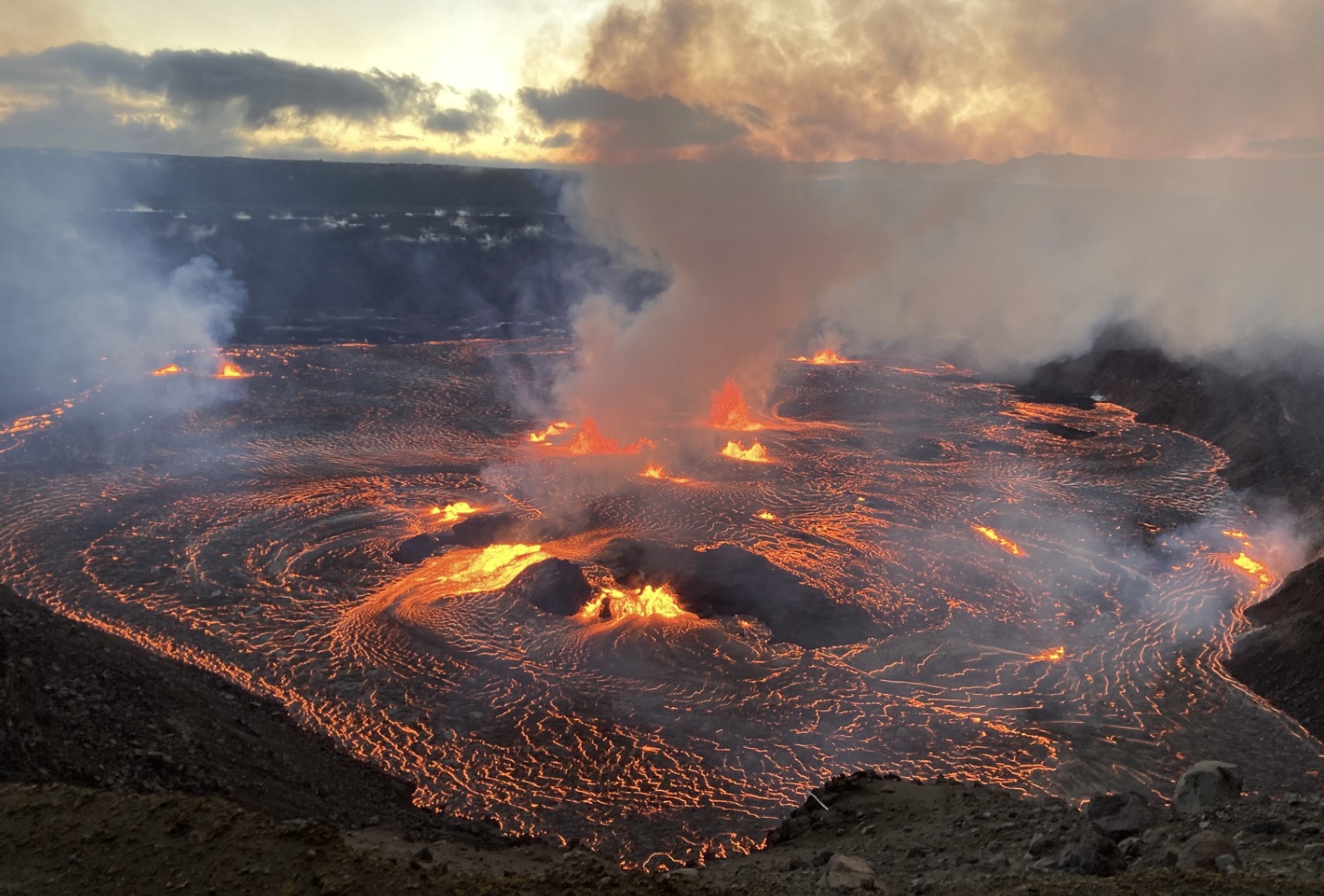
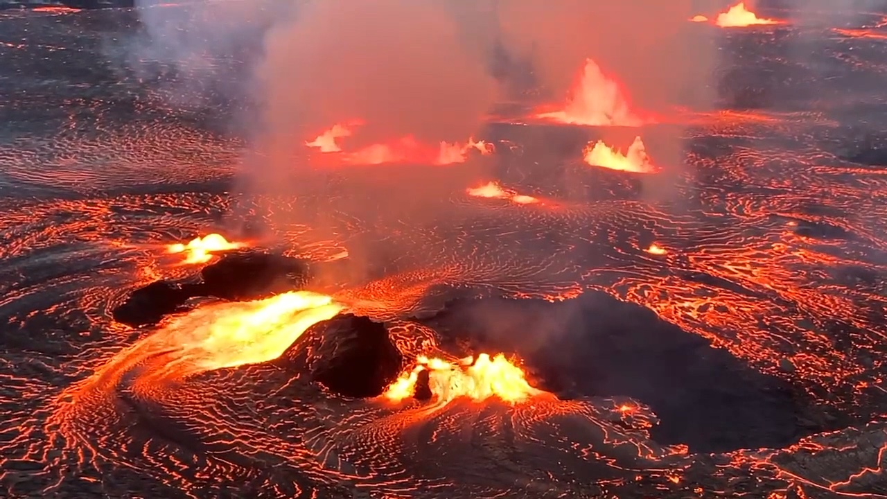
Multiple minor fountains are active on Halema‘uma‘u crater floor; one fissure remains active on the southwest wall of the caldera. Fountain heights have decreased since the eruption onset and, as of approximately 3 p.m., were about 4-9 meters (13-30 feet) high. Initial lava flows inundated the crater floor (an area of approximately 1.5 square km or 370 acres) and added about 10 meters (32 feet) depth of new lava. A ring of elevated 1-2 meter-high (3-6 feet-high) lava surrounds the perimeter of the crater floor (like a bathtub ring), encircling continued lava flow activity across the crater floor.
Summit tilt switched from inflation to deflation around 5 a.m. HST, shortly after the eruption onset. Summit earthquake activity greatly diminished following the eruption onset and was replaced by continuous eruptive tremor (a signal associated with fluid movement). Volcanic gas emissions in the eruption area are elevated; a sulfur dioxide (SO2) emission rate of approximately 65,000 tonnes per day was measured between approximately 8 and 9 a.m. this morning, June 7, 2023. Residents of Pāhala, 20 miles (30 km) downwind of Kīlaueaʻs summit) reported a very light dusting of gritty fine ash and Peleʻs hair this morning.
Kīlauea’s volcano alert level and aviation color code will remain at WARNING/RED as hazards associated with the eruption onset are evaluated overnight.
Source : HVO
Photos : USGS
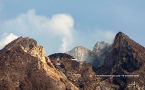
Philippines , Mayon :
MAYON VOLCANO BULLETIN , 8 June 2023 , 12:00 Noon
This serves as a notice of alert level raise from Alert Level 2 (increasing unrest) to Alert Level 3 (increased tendency towards a hazardous eruption) of Mayon Volcano.
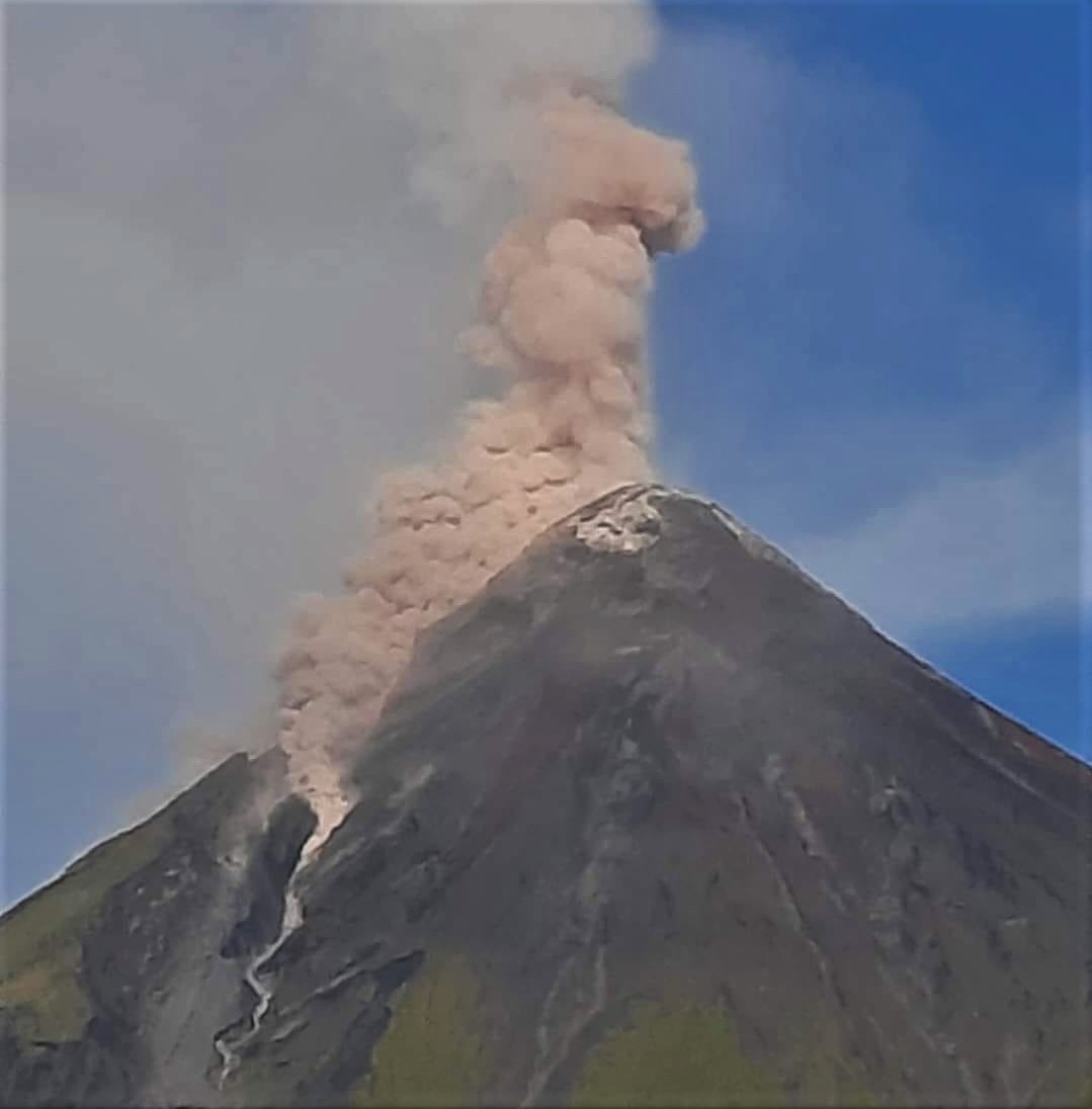
Since the Alert Level status was raised from Alert Level 1 to Alert Level 2 on 05 June 2023, repeated collapse of the growing summit dome of Mayon Volcano has generated an increasing number and volume of rockfall events. A total of 267 rockfall events and 2 volcanic earthquakes were recorded from 05 to 08 June, compared to 54 rockfall events from 01 to 04 June 2023. These events had durations of one (1) to three (3) minutes and transported lava debris within a kilometer range of the southern upper slopes. The volume of discrete rockfall events increased on 3 June based on the seismic record, signaling an increase in the rate of dome growth. Three (3) pyroclastic density current or PDC events on the Bonga (southeast) and Basud (east) Gullies were observed today at 6:18 AM, 9:53 AM and 11:00 AM. The PDCs lasted four to five minutes based on the seismic record and emplaced within a kilometer of the summit crater.
In contrast, SO2 emission remains at baseline or background levels. Short-term ground deformation data from continuous GPS, electronic tilt, and EDM monitoring indicate persistent inflation of the southeastern middle and upper slopes since February 2023. The overall monitoring parameters indicate that very slow extrusion of shallow degassed magma is ongoing and is incrementally increasing in rate; i.e., effusive magmatic eruption is taking place.
Daily visual and webcam observations of Mayon’s summit crater revealed more frequent rockfalls at the summit lava dome starting in the last week of April, indicating aseismic dome growth. The lava dome increased in volume by about 83,000 cubic meters during 3 February-9 May, with a total addition of nearly 164,000 cubic meters since 20 August 2022. Sulfur dioxide emission averages were as high as 576 tons per day on 29 April and 162 tons per day on 23 May.
Residents were reminded to stay away from the 6-km-radius Permanent Danger Zone (PDZ).
Source : Phivolcs , GVP
Photo : Ken Berania.
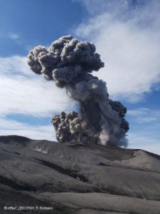
Japan , Sakurajima :
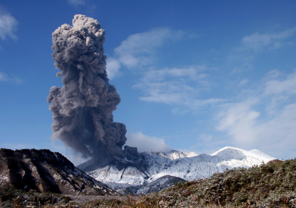
JMA reported ongoing activity at both Minamidake Crater and Showa Crater (Aira Caldera’s Sakurajima volcano) during 29 May-5 June. On 29 May sulfur dioxide emissions were high at 2,900 tons per day. Crater incandescence was observed nightly at both craters during 29 May-2 June, and very small eruptive events periodically occurred. Eruptive events at Minamidake at 02h37 and 04h54 on 4 June produced ash plumes that rose about 1.1 km above the crater rim. An explosion at 00h12 on 5 June generated an ash plume that rose 1 km and drifted SE, and ejected blocks 500-700 m from the crater. At Showa, eruptive events at 02h11, 03h52, 04h40, and 14h36 on 5 June generated ash plumes that rose 1.3-1.5 km above the crater rim and drifted SE and E, or rose straight up; blocks were ejected as far as 300 m from the crater. The Alert Level remained at 3 (on a 5-level scale), and residents were warned to stay 2 km away from both craters.
The Aira caldera in the northern half of Kagoshima Bay contains the post-caldera Sakurajima volcano, one of Japan’s most active. Eruption of the voluminous Ito pyroclastic flow accompanied formation of the 17 x 23 km caldera about 22,000 years ago. The smaller Wakamiko caldera was formed during the early Holocene in the NE corner of the Aira caldera, along with several post-caldera cones. The construction of Sakurajima began about 13,000 years ago on the southern rim of Aira caldera and built an island that was finally joined to the Osumi Peninsula during the major explosive and effusive eruption of 1914. Activity at the Kitadake summit cone ended about 4850 years ago, after which eruptions took place at Minamidake. Frequent historical eruptions, recorded since the 8th century, have deposited ash on Kagoshima, one of Kyushu’s largest cities, located across Kagoshima Bay only 8 km from the summit. The largest historical eruption took place during 1471-76.
Source : GVP
Photo : S.Nakano
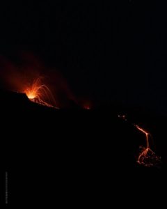
Costa Rica , Rincon de la Vieja :
OVSICORI-UNA reported that increased eruptive activity continued at Rincón de la Vieja during 30 May-6 June. Seismic instruments continued to record low-magnitude volcano-tectonic earthquakes located S of the Pailas sector of Parque Nacional Rincón de la Vieja. Reports describing phreatic eruption events were issued almost daily. A phreatic event at 22h15 on 30 May ejected incandescent material within the vicinity of the crater. A small phreatic eruption at 17h53 on 31 May generated a small pyroclastic flow that traveled a short distance from the crater. Moderate phreatic eruptions were recorded during 1-2 June; the most energetic event occurred at 09h02 and generated a plume of steam, gas, and ash that rose to 1.5 km above the crater and drifted N. OVSICORI-UNA raised the Alert Level from 2 to 3 (the third highest on a four-level scale) at 16h50 on 2 June due to significant seismicity and significant emissions recorded during May.

Eruptive events were recorded during 3-4 June. The most energetic event occurred at 06h24 on 3 June and generated a steam-and-gas plume that rose 1.5 km and drifted W. An eruptive event at 05h26 on 4 June first generated emissions that rose to 500 m, followed at 0529 by a second plume of steam-and-gas rose to 3.5 km above the crater and drifted N. Steam-and-gas plumes with low ash content were generated from eruptive events during the nights of 4-5 June; the plumes rose 1-1.5 km above the crater and drifted W. At 02h59 on 6 June a small phreatic eruption generated a plume that rose to 3 km and drifted NW.
During a press conference held by OVISOCORI-UNA, RSN, and CNE on 5 June, the public was reminded that although the recent volcanic activity is normal for Rincon de la Vieja, it is still necessary to remain cautious and that community emergency committees will remain activated. CNE maintained a Green Alert (first alert level on a four-color scale) for the districts of Dos Ríos (13 km N) and Aguas Claras (3 km NW) in the canton of Upala (22 km ENE), as well as the districts of Cañas Dulces (24 km ESE), Curubandé (18 km SW), and Mayorga (15 km W) in the canton of Liberia (21 km SW). The CNE reminded the public to stay away from the Azul, Pénjamo, and Azufrada rivers.
Source : GVP
Photo : Federico Chavarría-Kopper – Ovsicori
Mexico , Popocatepetl :
June 07, 11:00 (June 07, 17:00 GMT)
Activity in the last 24 hours
43 exhalations were detected accompanied by water vapour, other volcanic gases and occasionally ash in minimal quantities; as well as two minor explosions yesterday at 5:34 p.m. and today at 2:39 a.m.
There were also 187 minutes of low to moderate amplitude, high frequency tremors. In addition, a volcano-tectonic earthquake was detected, of magnitude 2, recorded yesterday at 11:28.
At the time of publication of this report, an emission of water vapor, volcanic gases and slight amounts of ash is observed in a South-South-East direction.
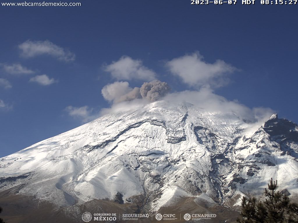
The National Civil Protection Coordination announced yesterday that, based on the recommendation of the Scientific Advisory Committee (CCA) of the National Civil Protection System for the Popocatépetl Volcano, it has taken the decision to bring back the warning signal fire volcanic at yellow level Phase 2.
Source et photo : Cenapred.