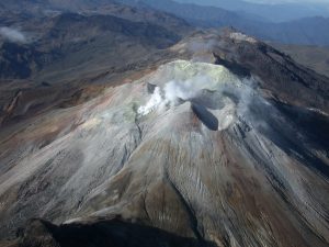
Costa Rica , Rincon de la Vieja :
ERUPTION REPORT – OVSICORI-UNA
Location: N10.83 W85.34
Height of the massif: 1916mts. (6284 feet)
Date: 02 June 2023, Time: 09:02
Plume height (above crater): 4920 feet. (1500 meters)
Plume observation source:
Observed on webcams, seismograms, sound recorders and reported by locals
Observed activity:
An eruption is recorded with the presence of ash and a plume of water vapor and gas that rises 1500 meters
The plume disperses to the north.
Activity Level: Warning
This eruption was observed from different sites surrounding the volcano. Due to the direction of the wind this morning, it is likely that there will be ash fall in localities north of the volcano, said the National Emergency Commission (CNE).
In addition, people are reminded to stay away from the Azul, Pénjamo and Azufrada rivers due to the volcanic mudslides that may occur, as well as to protect themselves from the ashes that may fall.
The CNE maintains a green alert for the districts of Dos Ríos and Aguas Claras in the canton of Upala, as well as the districts of Mayorga, Cañas Dulces and Curubandé in the canton of Liberia due to the frequent volcanic activity that the volcano has presented for several weeks.
Sources : Ovsicori , teletica.com.
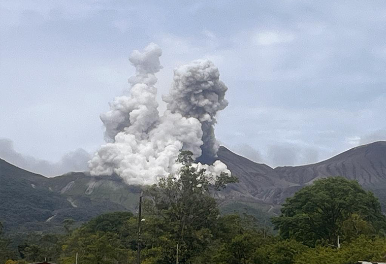
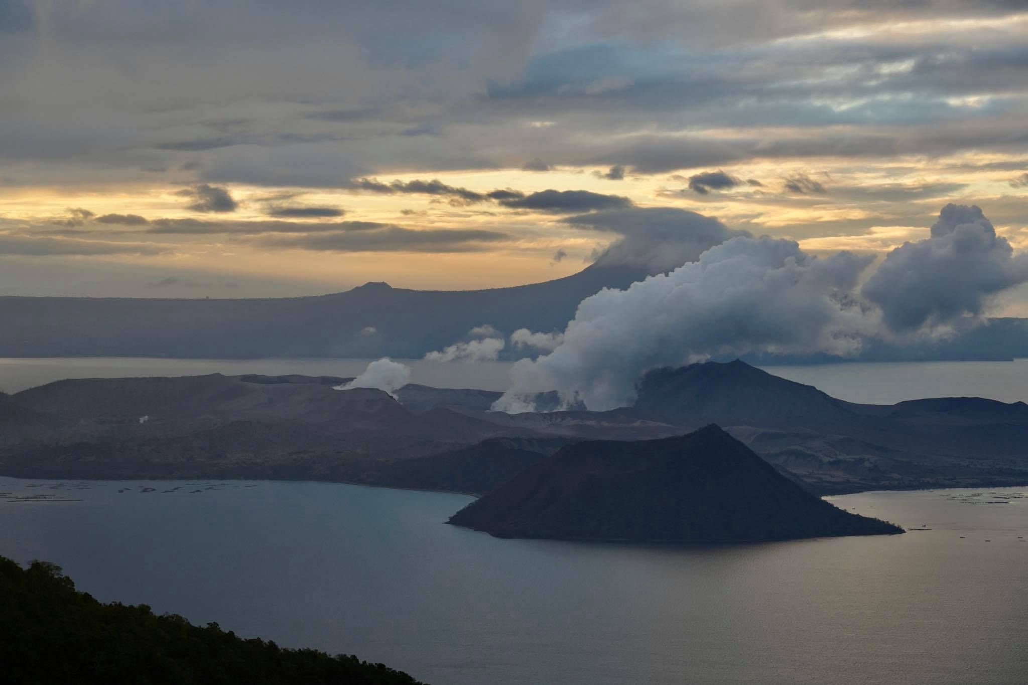
Philippines , Taal :
NOTICE OF ACTIVITY FOR TAAL VOLCANO, June 2, 2023, 7:00 p.m.
This is an advisory regarding continued low activity at Taal Volcano.
Beginning at 6:35 a.m. this morning, June 2, 2023, a weak and shallow but continuous volcanic tremor below the Daang Kastila fissure was recorded by the 15 seismic stations of Taal Volcano’s volcanic sensor network. This coincides with the warming of the northern part and the rise of hot volcanic fluids in the main crater of Taal which has been observed by surveillance cameras. First there has been an increase in SO2 emissions over the past two weeks based on an increase to 5,360 tonnes per day of average measurements from May 22 to June 1, 2023 against a maximum of 3,000 tonnes per day. day from April 1 to May 21, 2023, as well as the notable swelling of the southwestern part of Volcano Island since the fourth week of May 2023 following its prolonged deflation. These data indicate that there is shallow hydrothermal activity caused by another magma feeding episode beneath the volcano.
DOST-PHIVOLCS reminds the public that Taal Volcano has been raised to Alert Level 1, which means the volcano is not in a normal state and its activity or threat of eruption has not yet decreases. In the event of a worsening or drastic change in the monitoring parameters, the alert level can be raised to alert level 2. On the other hand, if the monitoring parameters return to the reference level after a sufficient monitoring period, the Alert Level may Alert Level to Alert Level 0. At the current Alert Level 1, sudden steam or phreatic explosions, volcanic earthquakes, weak ash fall, and buildup or emission of toxic gases may occur in the environment of the Taal volcano island or TVI. DOST-PHIVOLCS strongly suggests a strict ban on entering the TVI, which is Taal Volcano’s Permanent Danger Zone or PDZ, especially around and within the Main Crater and Daang Castilla Fissure. Local Government Units (LGUs) are urged to continue to assess the damage and condition of roads and paths and to strengthen preparedness, contingency and communication methods in case the condition of the volcano changes. People are advised to pay attention to the movement of the ground showing a crack, possible ash rains and weak earthquakes. Civil aviation authorities are advised to advise pilots not to fly near the volcano to avoid sudden eruptions of ash and large rock fragments or fly ash carried by high winds which could pose a hazard to people. aircraft.
DOST-PHIVOLCS is closely monitoring the status of Taal Volcano and will immediately notify all concerned of any changes.
Source : Phivolcs
Photo : Raffy Tima.
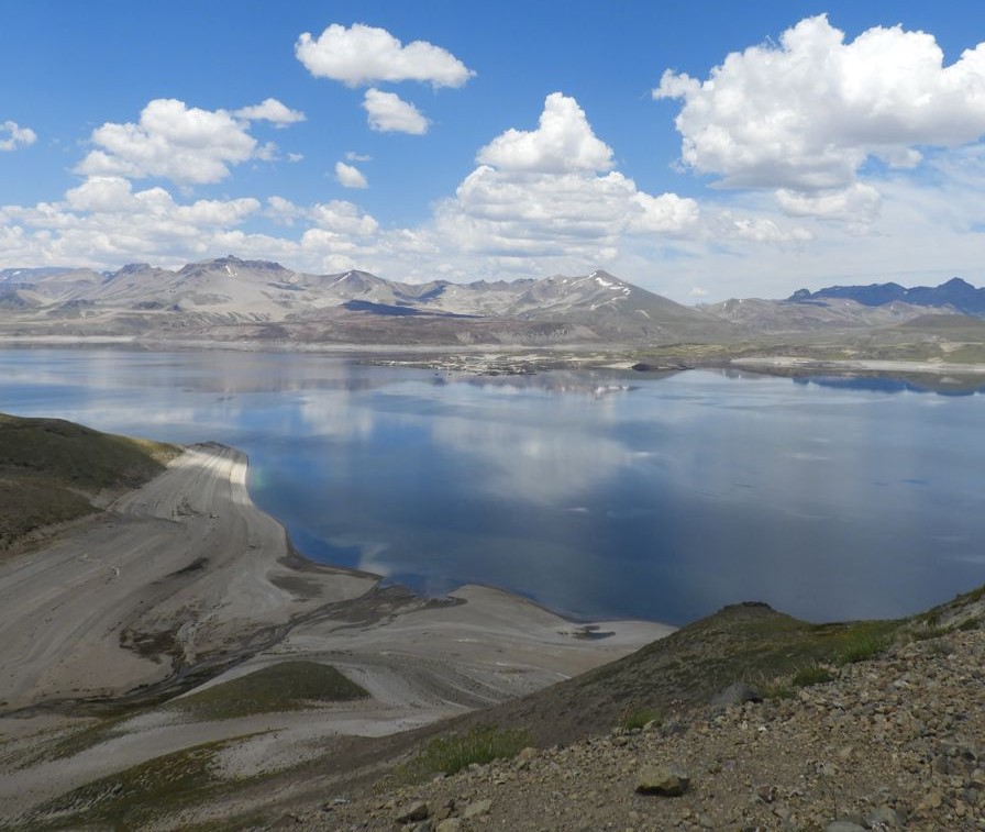
Chile , Laguna del Maule :
Special Report on Volcanic Activity (REAV), Maule region, Laguna del Maule volcanic complex, June 01, 2023, 9:00 p.m. local time (mainland Chile)
The National Geology and Mining Service of Chile (Sernageomin) announces the following PRELIMINARY information, obtained through the monitoring equipment of the National Volcanic Monitoring Network (RNVV), processed and analyzed at the Volcanological Observatory of the Andes del Sud ( Ovdas):
On Thursday, June 01 since 7:00 p.m. local time (23:00 UTC), the monitoring stations installed near the Laguna del Maule volcanic complex recorded a swarm of earthquakes, associated with volcano-tectonic activity (VT). At the time of issuing this report, more than 100 events had been recorded, including the event of greatest magnitude located 8.2 km west-southwest of the center of the lagoon.
The characteristics of the earthquake of greatest magnitude recorded for the moment after its analysis are as follows:
ORIGINAL TIME: 8:34 p.m. local time (00:34 UTC)
LATITUDE: 36.112°S
LONGITUDE: 70.572°E
DEPTH: 1.4 km
LOCAL MAGNITUDE: 0.4 (ML)
Comments:
During the issuance of this report, the volcano-tectonic seismicity continues to be recorded, with low magnitude events (ML<1.0). Similarly, the localized seismicity is focused in an area close to the Nieblas station located southwest of the center of the lagoon.
The volcanic technical alert remains at the Yellow level.
Source : Sernageomin.
Photo : Cegemar.
Colombia , Nevado del Ruiz :
Manizales, June 2, 2023 11:40 a.m.
Regarding the monitoring of the activity of the NEVADO DEL RUIZ VOLCANO, the MINISTRY OF MINES AND ENERGY through the COLOMBIAN GEOLOGICAL SERVICE (SGC) informs that:
From 09:00 yesterday (June 1) until the time of publication of this bulletin, the seismic activity associated with the fracturing of the rock inside the volcanic edifice has increased in number of earthquakes and in seismic energy. , compared to June 1. The earthquakes were located mainly about 3 and 4 km west-northwest of the Arenas crater, at depths between 4 and 5 km. The maximum magnitude recorded was 1.0 corresponding to the earthquake recorded at 1:37 p.m., located 3.7 km west-northwest of the Arenas crater, at a depth of 5 km from the summit of the volcano. Small earthquakes have also been recorded, although to a small extent, in the Arenas crater, which are associated with the activity of the lava dome (bulge or mound) located at the bottom of the crater.
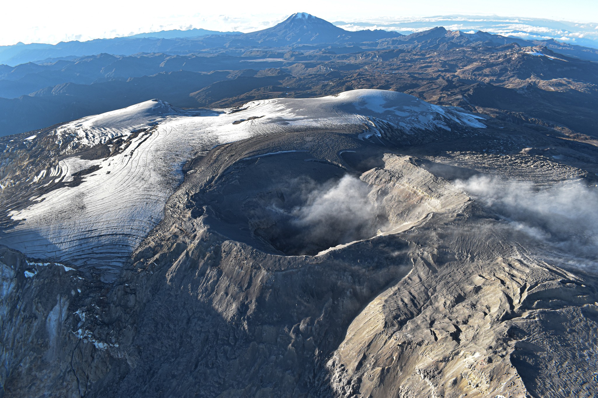
On the other hand, the seismic activity related to the movement of fluids inside the volcanic conduits showed similar levels in the number of earthquakes and in the seismic energy released, compared to May 31. Some of the seismic signals were associated with pulsating ash emissions confirmed by web cameras used for volcanic monitoring.
Regarding surface activity, the maximum height of the column of gas and / or ash was 900 m measured from the summit of the volcano and continued to show a preferential direction of dispersion towards the northwest of the volcanic edifice. In addition, the degassing of sulfur dioxide (SO2) and the release of water vapor from the crater into the atmosphere are maintained.
Source et photo : SGC.
Indonesia , Ili Lewotolok :
An eruption of G. Ili Lewotolok occurred on Friday, June 02, 2023 at 09:40 WITA with the height of the ash column observed at ± 700 m above the summit (± 2123 m above sea level) . The ash column was observed to be white, gray to black with thick intensity, oriented southwest and west. This eruption was recorded on a seismograph with a maximum amplitude of 25.3 mm and a duration of 64 seconds.
VOLCANO OBSERVATORY NOTICE FOR AVIATION – VONA
Issued : June 02 , 2023
Volcano : Ili Lewotolok (264230)
Current Aviation Colour Code : ORANGE
Previous Aviation Colour Code : orange
Source : Ili Lewotolok Volcano Observatory
Notice Number : 2023LEW036
Volcano Location : S 08 deg 16 min 19 sec E 123 deg 30 min 18 sec
Area : East Nusa Tenggara, Indonesia
Summit Elevation : 4554 FT (1423 M)
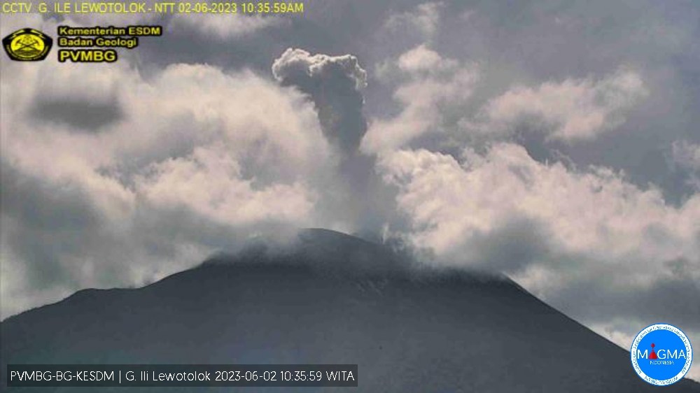
Volcanic Activity Summary :
Eruption with volcanic ash cloud at 02h33 UTC (10h33 local).
Volcanic Cloud Height :
Best estimate of ash-cloud top is around 7754 FT (2423 M) above sea level or 3200 FT (1000 M) above summit. May be higher than what can be observed clearly. Source of height data: ground observer.
Other Volcanic Cloud Information :
Ash cloud moving from southwest to west. Volcanic ash is observed to be white to gray. The intensity of volcanic ash is observed to be thick.
Remarks :
Eruption recorded on seismogram with maximum amplitude 16.5 mm and maximum duration 73 second.
Source : Magma Indonésie.