April 04 , 2023.
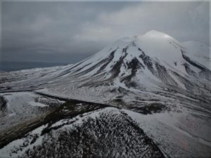
Colombia , Nevado del Ruiz :
The government of Caldas yesterday held a Unified Command Post (PMU) in the municipality of Villamaría with relief agencies and local and departmental authorities to make decisions on the change in the level of activity of the Nevado del Ruiz volcano, which turned from yellow to orange on Thursday evening and that means probability of eruption in days or weeks.
The governor of Caldas, Luis Carlos Velásquez, indicated that in the area of influence of the volcano, the department has 300 families located in the upper, middle and lower parts. « We are going to proceed, under the direction of the office of the mayor of Villamaría, to the evacuation of 40 of them, it is a preventive evacuation for those who live around the areas closest to the volcano. »
It has also been decided that 23 educational institutions located in a risk zone, 10 kilometers around the volcano, will start virtual classes from Easter week (April 10).
Manizales, April 3, 2023 9:40 a.m.
Regarding the monitoring of the activity of the NEVADO DEL RUIZ VOLCANO, the MINISTRY OF MINES AND ENERGY through the COLOMBIAN GEOLOGICAL SERVICE (SGC) informs that:
The recording of rock fracturing seismicity continues inside the volcanic edifice. Yesterday April 2, 5,400 events were recorded, including 5 with a magnitude of 2.0 ML, with the recording of an earthquake at 11:22 a.m., of magnitude 2.3 ML, located 4.3 km north of Southwest of the crater. Seismicity remains localized in the southwestern sector of the volcanic edifice at a distance from the crater of between 2.0 and 5.0 km.
On the other hand, the recording of seismic activity related to the movement of fluids inside the volcanic conduits continues, which has been associated with confirmed ash emissions and degassing, which maintains rates similar to the day before. The maximum height of the column of gas and / or ash observed yesterday was 1200 m measured from the summit of the volcano and the direction of dispersion of the column varied between the South-West and the North-West of the volcano. Officials of the Los Nevados National Natural Park yesterday reported an ash fall in the Brisas and Potosí sectors.
It is important to point out that the activity of the volcano at the ORANGE LEVEL can fluctuate and sometimes decrease compared to the previous days, without this meaning that the volcano has returned to a lower level of activity.
To change the level and return to the yellow level, a prudential time is required where trends and patterns can be observed that allow us to deduce the possible decrease in activity, which is why it is warned that the level of activity of the Nevado del Ruiz volcano will remain at the ORANGE LEVEL for several weeks. Meanwhile, if there is an acceleration of processes suggesting an impending eruption or the eruption itself occurring, the activity level will turn red.
The community is recommended to remain calm, but to be attentive to the information provided by the Colombian Geological Service on the evolution of the state of the volcano.
The level of activity of the volcano remains at the ORANGE LEVEL of activity or (II): PROBABLE ERUPTION IN TERM OF DAYS OR WEEKS
Source and photo : La Patria , SGC .
Peru , Sabancaya :
Analysis period: from March 27, 2023 to April 2, 2023, Arequipa, April 3, 2023.
Alert level: ORANGE
The Geophysical Institute of Peru (IGP) reports that the eruptive activity of the Sabancaya volcano remains at moderate levels, that is to say with the recording of an average of 22 daily explosions, with columns of ash and of gas up to 1.9 km altitude above the summit of the volcano and their subsequent dispersion. Therefore, for the following days, no significant change is expected in eruptive activity.
The IGP recorded and analyzed the occurrence of 287 earthquakes of volcanic origin, associated with the circulation of magmatic fluids inside the Sabancaya volcano. An average of 22 explosions was recorded daily, in addition to recording Volcano-Tectonic (VT) type events associated with rock fracturing inside the Sabancaya volcano.
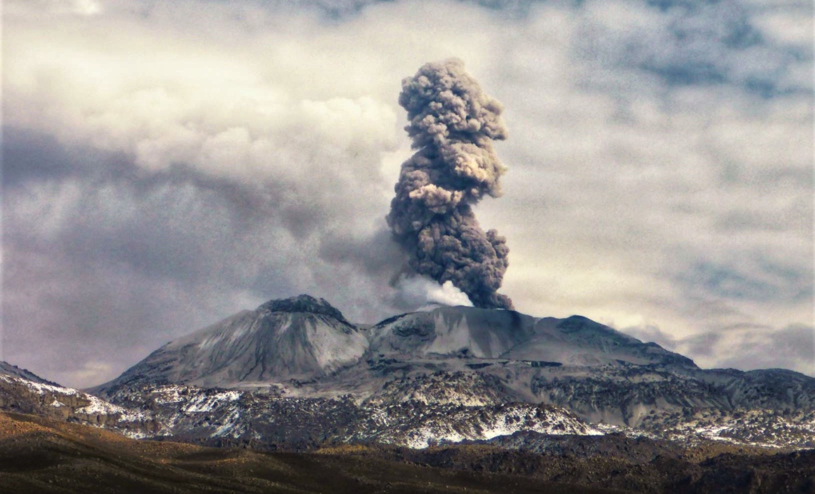
Monitoring the deformation of the volcanic structure using GNSS techniques (processed with fast orbits) does not show any significant anomalies. Visual surveillance identified columns of gas and ash up to 1.9 km above the summit of the volcano, which were scattered towards the West, South, South-West and North-West sectors. of the Sabancaya. Satellite recordings have identified the presence of 2 thermal anomalies, with a maximum value of 3 MW, associated with the presence of a lava body on the surface of the crater of the volcano.
RECOMMENDATIONS
• Keep the volcanic alert level orange.
• Do not approach within a radius of less than 12 km from the crater.
Source : Cenvul
Photo : Andina.
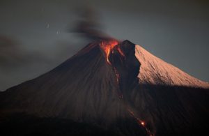
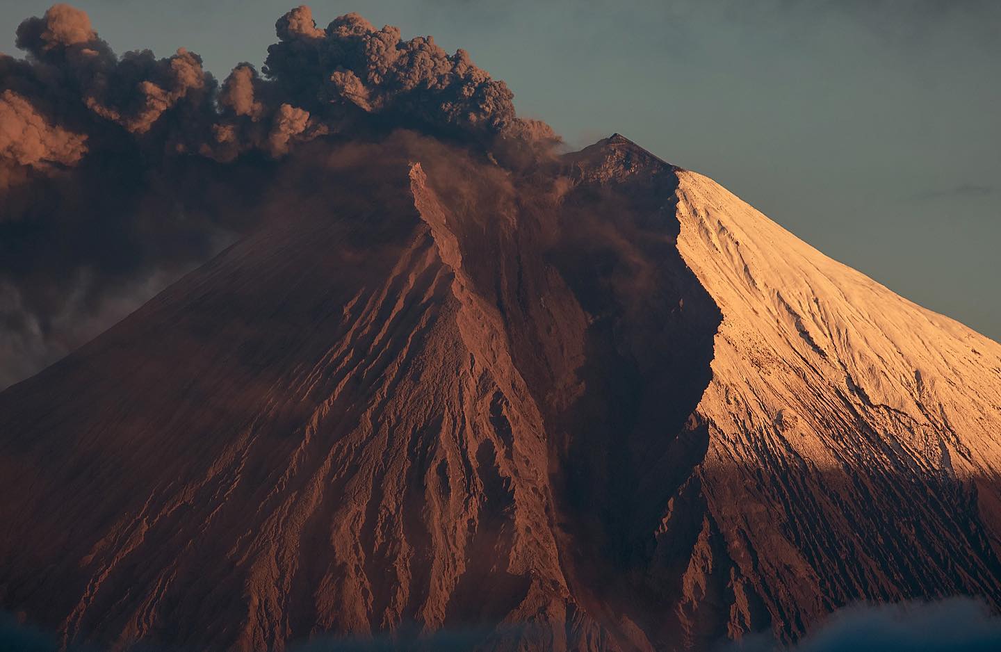
Kamchatka , Sheveluch :
VOLCANO OBSERVATORY NOTICE FOR AVIATION (VONA)
Issued: April 03 , 2023
Volcano: Sheveluch (CAVW #300270)
Current aviation colour code: ORANGE
Previous aviation colour code: orange
Source: KVERT
Notice Number: 2023-42
Volcano Location: N 56 deg 38 min E 161 deg 18 min
Area: Kamchatka, Russia
Summit Elevation: 3283 m (10768.24 ft), the dome elevation ~2500 m (8200 ft)

Volcanic Activity Summary:
The growth of the lava dome continues, a strong fumarole activity, an incandescence of the lava dome, sometimes explosions, and hot avalanches accompanies this process. Satellite data by KVERT showed a weak ash plume extended about 30 km to the east from the volcano.
An extrusive eruption of the volcano continues. Ash explosions up to 10-15 km (32,800-49,200 ft) a.s.l. could occur at any time. Ongoing activity could affect international and low-flying aircraft.
Volcanic cloud height:
2500-3000 m (8200-9840 ft) AMSL Time and method of ash plume/cloud height determination: 20230403/0046Z – Suomi NPP 15m16
Other volcanic cloud information:
Distance of ash plume/cloud of the volcano: 30 km (19 mi)
Direction of drift of ash plume/cloud of the volcano: E / azimuth 96 deg
Time and method of ash plume/cloud determination: 20230403/0046Z – Suomi NPP 15m16
Source : Kvert.
Photo : Yu. Demyanchuk, IVS FEB RAS, KVERT
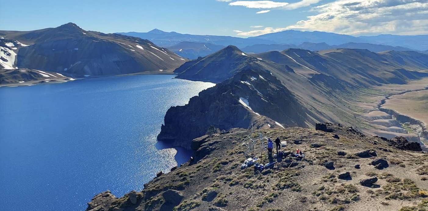
Chile , Laguna del Maule :
Special Report on Volcanic Activity (REAV), Maule Region, Laguna del Maule Volcanic Complex, April 3, 2023, 7:00 p.m. local time (mainland Chile)
The National Geology and Mining Service of Chile (Sernageomin) discloses the following information, obtained through the monitoring equipment of the National Volcanic Monitoring Network (RNVV), processed and analyzed at the Observatory of Volcanoes of the Southern Andes ( Ovdas):
The seismic activity of the Laguna del Maule Volcanic Complex has evolved in recent days.
Since last Thursday, March 30, 2023, the Sernageomin instrumental network has recorded the beginning of a seismic process that is still continuing. This seismicity classified as volcano-tectonic (associated with processes of rupture of rocky material), is mainly characterized by its location in an elongated zone in a North-West / South-East direction about 10 km South-West of the center of the lagoon and with a depth range of up to 8 km. It is important to indicate that, although the development of this seismicity is the longest since monitoring began in 2012, its magnitudes have been of low energy.
However, the record of sporadic earthquakes of increasing magnitude stands out, such as those that occurred today April 3 with local magnitudes of 2.5, 2.8 and 2.9, at depths between 4 ,5 and 8 km, located in the Nieblas sector.
Deformation rates remain unchanged, although the inflationary process continues with a monthly rate of 1.5 cm/month. Other activity parameters such as morphological changes, temperature analysis and SO2 emission into the atmosphere, by remote sensing, remain unchanged so far.
The zone of possible assignment by volcanic hazards is located within a radius of 2 km around the CO2 emission center
Due to the abnormal nature of the current seismic process, the technical alert has been raised to the Yellow level.
Source : Sernageomin
Photo : Neuqueninforma.gob.ar
Ecuador , Sangay :
DAILY REPORT OF THE STATE OF SANGAY VOLCANO, Monday April 03, 2023.
Information Geophysical Institute – EPN.
Surface activity level: High, Surface trend: No change
Internal activity level: High, Internal trend: No change
Seismicity: From April 02, 2023, 11:00 a.m. to April 03, 2023, 11:00 a.m.:
Due to transmission problems from the reference station, the seismic event count was completed within about 9 signal hours.
Explosion (EXP) 59
Emission Tremors (TREMI ) 25
Long Periods (LP): 10
Rains / Lahars:
Rain events were recorded in the area which did not generate signals associated with mudslides and debris. **In case of heavy rains, secondary lahars can be generated in the Volcán, Upano rivers and other tributaries**
Emission / Ash Column:
Due to the cloudiness of the sector, there are no observations of surface activity in the sector, however, the VAAC in Washington recorded 2 alerts for the ash emissions observed in the satellites, which reached heights of 1100 meters above crater level in a westerly direction.
Other Monitoring Parameters:
The FIRMS system records 1 thermal alert while MIROVA-MODIS records 1 moderate thermal alert and MIROVA-VIIRS records 1 high thermal alert (219 MW) in the last 24 hours.
Gas:
The MOUNTS system recorded 260.1 tons of sulfur dioxide (SO2), measured on 2023-02-04 at 2:29 p.m. TL.
Observation:
Cloudiness was permanent in the area, preventing direct observation of surface activity.
Alert level: Orange.
Source : IGEPN.
Photo : Eqphos_fotografía