April 03 , 2023.
Colombia , Nevado del Ruiz :
Manizales, April 2, 2023 9:30 a.m.
Regarding the monitoring of the activity of the NEVADO DEL RUIZ VOLCANO, the MINISTRY OF MINES AND ENERGY through the COLOMBIAN GEOLOGICAL SERVICE (SGC) informs that:
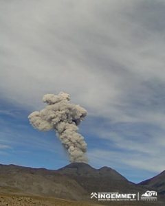
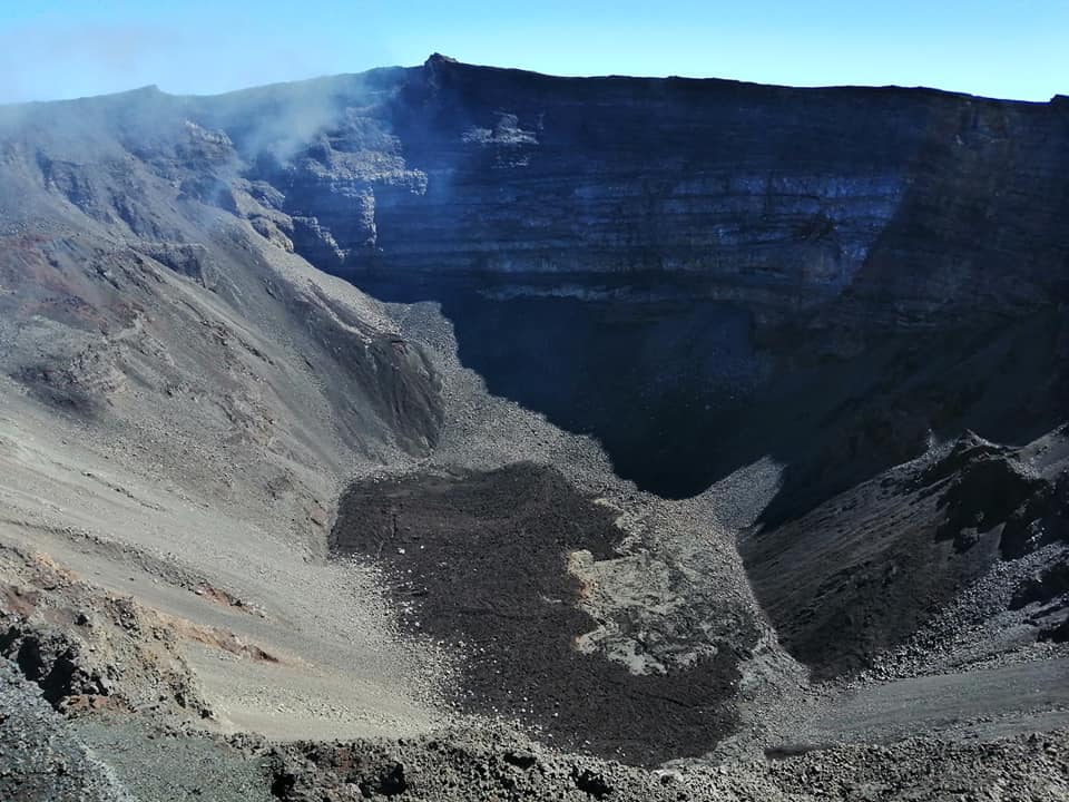
The recording of rock fracturing seismicity continues inside the volcanic edifice. Yesterday April 1, 10,400 events were recorded, reaching a maximum magnitude of 3.1 ML corresponding to the 10:40 a.m. earthquake. Seismicity remains localized in the southwestern sector of the volcanic edifice at a distance from the crater of between 2.0 and 5.0 km. The increase in recorded earthquake magnitudes stands out, with yesterday being the day with the highest seismic energy released since March 24. The recording of seismic activity related to the movement of fluids inside the volcanic conduits continues, which has been associated with confirmed ash emissions and a slight increase in degassing compared to the previous day. The maximum height of the column of gas and / or ash observed yesterday was 1200 m measured from the summit of the volcano and the direction of dispersion of the column prevailed towards the southwest of the volcano.

It is important to emphasize that the activity of the volcano at the ORANGE LEVEL can fluctuate and sometimes decrease compared to the previous days, without this meaning that it has returned to a lower level of activity. To change the level and return to the yellow level, a prudential time is required where trends and patterns can be observed that allow us to deduce the possible decrease in activity, which is why it is warned that the level of activity of the Nevado del Ruiz volcano will remain at the ORANGE LEVEL for several weeks. Meanwhile, if there is an acceleration of processes suggesting an impending eruption or the eruption itself occurring, the activity level will turn red.
The community is recommended to remain calm, but to be attentive to the information provided by the Colombian Geological Service on the evolution of the state of the volcano.
The level of activity of the volcano remains at the ORANGE LEVEL of activity or (II): PROBABLE ERUPTION IN TERM OF DAYS OR WEEKS
Source : SGC
Photo : Carlos Ortega
United – States , Yellowstone :
Saturday, April 1, 2023, 9:49 AM MDT (Saturday, April 1, 2023, 15:49 UTC)
44°25’48 » N 110°40’12 » W,
Summit Elevation 9203 ft (2805 m)
Current Volcano Alert Level: NORMAL
Current Aviation Color Code: GREEN
Recent Work and News
No eruptions of Steamboat Geyser were detected during the month of March, and the total number of eruptions for the year remains at two. The Norris temperature monitoring network and seismic station YNM were down throughout the month, but the streamgage on Tantalus Creek, through which all water from Norris Geyser Basin drains, did not record obvious spikes that would be associated with Steamboat eruptions.
Seismicity
During March 2023, the University of Utah Seismograph Stations, responsible for the operation and analysis of the Yellowstone Seismic Network, located 354 earthquakes in the Yellowstone National Park region. The largest event of the month was a minor earthquake of magnitude 3.7 located about 3 miles southeast of Lake, Yellowstone National Park, on March 29 at 8:24 AM MDT. This event was part of a swarm of 106 earthquakes that occurred in the area starting on March 29 and that continued through the end of the month.

March seismicity in Yellowstone was marked by two swarms:
1. A swarm of 147 earthquakes, centered about 3 miles east-southeast of West Yellowstone, Montana, occurred during March 13–18. The largest earthquake, a magnitude 2.7, took place on March 13 at 11:03 AM MDT.
2. A swarm of 106 earthquakes, beneath the northern portion of Yellowstone Lake approximately 3 miles south southeast of Lake, Yellowstone National Park, began on March 29 and continued through the end of the month. The sequence included magnitude 3.1 and 3.7 earthquakes, the latter being the largest of the month (detailed above), and 31 earthquakes in the magnitude-two range.
Earthquake sequences like these are common and account for roughly 50% of the total seismicity in the Yellowstone region.
Yellowstone earthquake activity is currently at elevated levels compared with typical background activity.
Ground Deformation
Continuous GPS stations in Yellowstone Caldera continued to record gradual subsidence at a rate of several centimeters (1–2 inches) per year, which has been ongoing since 2015. Since October, about 2 centimeters (less than 1 inch) of subsidence has occurred in the area of Norris Geyser Basin.
Source : YVO.
Photo : Mammoth Hot Springs ,Brocken Inaglory .
Alaska , Trident :
58°14’3″ N 155°6’9″ W,
Summit Elevation 3599 ft (1097 m)
Current Volcano Alert Level: ADVISORY
Current Aviation Color Code: YELLOW
Occasional small, shallow earthquakes continued to occur in the vicinity of Trident Volcano over the past 24 hours, including a few low-frequency earthquakes and periods of seismic tremor. No surface activity was seen in clear satellite or webcam images.
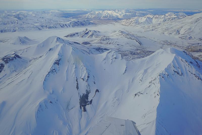
Aerial view of Trident volcano as viewed from the south. The southeast fumarole field on Trident I is visible in lower center of the image. The Valley of Ten Thousand Smokes can be seen in the background.
The current period of seismic unrest began on August 24, 2022. Increases in seismic activity have been detected previously at Trident Volcano and other similar volcanoes, with no subsequent eruptions. We expect additional shallow seismicity and other signs of unrest, such as gas emissions, elevated surface temperatures, and surface deformation to precede any future eruption, if one were to occur.
AVO monitors Trident Volcano with a local network of seismometers, a webcam, remote sensing data, and regional infrasound and lightning networks.
Source : AVO.
Photo : Lopez, Taryn/ Alaska Volcano Observatory / University of Alaska Fairbanks, Geophysical Institute .
La Réunion , Piton de la Fournaise :
Seismicity
In March 2023, the OVPF-IPGP recorded at the level of the Piton de la Fournaise massif in total:
• 18 superficial volcano-tectonic earthquakes (0 to 2.5 km above sea level) under the summit craters;
• 10 deep earthquakes (below sea level);
• 33 long-period type earthquakes;
• 293 landslides.
The month of March 2023 will have been marked by low seismicity at the level of Piton de la Fournaise with an average of 0.6 superficial volcano-tectonic earthquake per day. Most of these events were located under the eastern rim of the Dolomieu crater.
The deep earthquakes were located under the eastern flank of the volcano.
The month of March will also have been marked by numerous landslides in the Cratère Dolomieu, at the Cassé de la Rivière de l’Est and at the level of the flow of the eruption of September-October 2022.
Deformation:
With the cessation of the last eruption on October 5, 2022, inflation of the entire edifice was recorded until October 23, followed by a period without significant deformation of the edifice.
Between December 30, 2022 and January 3, 2023, rapid inflation of the volcano was observed (with a summit elongation of about 1 cm max.), revealing rapid pressurization of the superficial magmatic reservoir (located at 1.5-2 km below the summit). Following this inflation, a deflation of the summit area was observed in January and February. In March 2023, a resumption of peak inflation was recorded. The inflation rate is low with less than 0.5 cm elongation of the summit area in a month. This inflation was linked to a weak pressurization of the superficial magma reservoir.
Balance sheet:
In March 2023, a slight recovery in summit inflation was recorded on the Piton de la Fournaise, testifying to a weak pressurization of the superficial magmatic reservoir. Seismicity remained low with an average of 0.6 superficial volcano-tectonic earthquakes per day under the summit craters.
Source : OVPF.
Read the full article : https://www.ipgp.fr/volcanoweb/reunion/Bulletins-Communiques/2023/Bulletins/OVPF_20230403_bullmensu.pdf
Photo : Nath Duverlie
Indonesia , Ili Lewotolok :
An eruption of G. Ili Lewotolok occurred on Monday, April 03, 2023 at 05:46 WITA with an ash column height observed at ± 500 m above the summit (± 1923 m above sea level) . The ash column was observed to be gray with a thick intensity oriented to the southeast. This eruption was recorded on a seismograph with a maximum amplitude of 38 mm and a duration of 89 seconds.
VOLCANO OBSERVATORY NOTICE FOR AVIATION – VONA
Issued : April 02 ,2023
Volcano : Ili Lewotolok (264230)
Current Aviation Colour Code : ORANGE
Previous Aviation Colour Code : orange
Source : Ili Lewotolok Volcano Observatory
Notice Number : 2023LEW016
Volcano Location : S 08 deg 16 min 19 sec E 123 deg 30 min 18 sec
Area : East Nusa Tenggara, Indonesia
Summit Elevation : 4554 FT (1423 M)
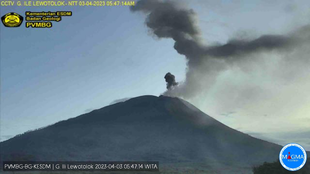
Volcanic Activity Summary :
Eruption with volcanic ash cloud at 21h46 UTC (05h46 local).
Volcanic Cloud Height :
Best estimate of ash-cloud top is around 6154 FT (1923 M) above sea level or 1600 FT (500 M) above summit. May be higher than what can be observed clearly. Source of height data: ground observer.
Other Volcanic Cloud Information :
Ash cloud moving to southeast. Volcanic ash is observed to be gray. The intensity of volcanic ash is observed to be thick.
Remarks :
Eruption recorded on seismogram with maximum amplitude 38 mm and maximum duration 89 second.
Source et photo : Magma Indonésie .