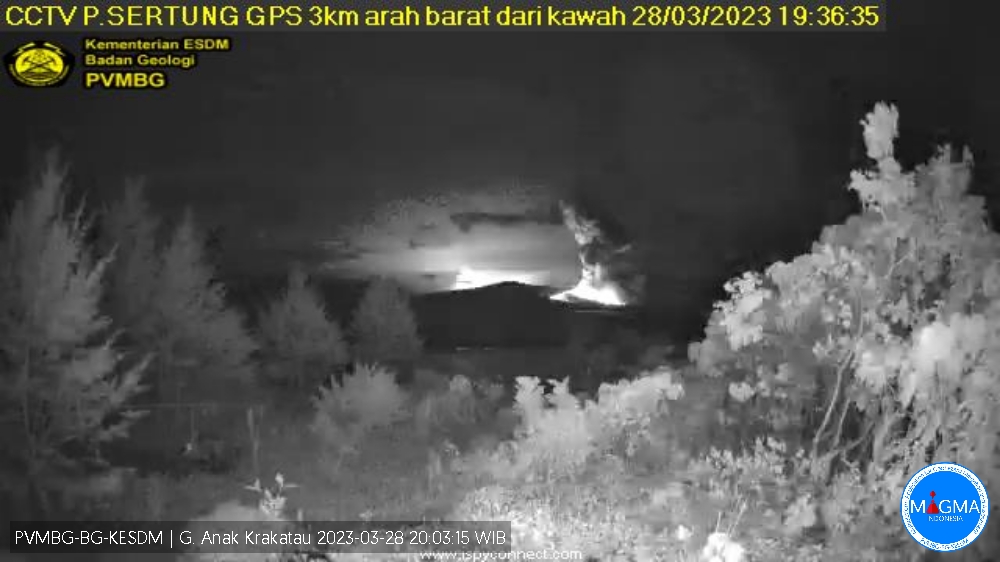
March 29 , 2023.
Indonesia , Anak Krakatau :
VOLCANO OBSERVATORY NOTICE FOR AVIATION – VONA
Issued : March 28 , 2023
Volcano : Anak Krakatau (262000)
Current Aviation Colour Code : ORANGE
Previous Aviation Colour Code : orange
Source : Anak Krakatau Volcano Observatory
Notice Number : 2023KRA044
Volcano Location : S 06 deg 06 min 07 sec E 105 deg 25 min 23 sec
Area : Lampung, Indonesia
Summit Elevation : 502 FT (157 M)
Volcanic Activity Summary :
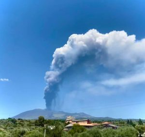
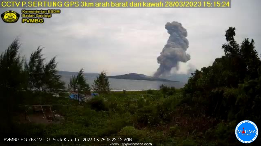
Eruption with volcanic ash cloud at 08h13 UTC (15h13 local).
Volcanic Cloud Height :
Best estimate of ash-cloud top is around 5302 FT (1657 M) above sea level or 4800 FT (1500 M) above summit. May be higher than what can be observed clearly. Source of height data: ground observer.
Other Volcanic Cloud Information :
Ash cloud moving to west. Volcanic ash is observed to be gray to dark. The intensity of volcanic ash is observed to be thick.
Remarks :
Eruption recorded on seismogram with maximum amplitude 70 mm and maximum duration 89 second.
Volcanic Activity Summary :
Eruption with volcanic ash cloud at 12h35 UTC (19h35 local).
Volcanic Cloud Height :
Best estimate of ash-cloud top is around 3702 FT (1157 M) above sea level or 3200 FT (1000 M) above summit. May be higher than what can be observed clearly. Source of height data: ground observer.
Other Volcanic Cloud Information :
Ash cloud moving to west. Volcanic ash is observed to be gray to dark. The intensity of volcanic ash is observed to be thick.
Remarks :
Eruption recorded on seismogram with maximum amplitude 72 mm and maximum duration 33 second.
Source et photos : Magma Indonésie
Peru , Sabancaya :
Analysis period: from March 20, 2023 to March 26, 2023, Arequipa, March 27, 2023.
Alert level: ORANGE
The Geophysical Institute of Peru (IGP) reports that the eruptive activity of the Sabancaya volcano remains at moderate levels, that is to say with the recording of an average of 35 daily explosions, with columns of ash and of gas up to 1.7 km altitude above the summit of the volcano and their subsequent dispersion. Therefore, for the following days, no significant change is expected in eruptive activity.
The IGP recorded and analyzed the occurrence of 431 earthquakes of volcanic origin, associated with the circulation of magmatic fluids inside the Sabancaya volcano. An average of 35 explosions was recorded daily, in addition to recording Volcano-Tectonic (VT) type events associated with rock fracturing inside the Sabancaya volcano
.

Monitoring the deformation of the volcanic structure using GNSS techniques (processed with fast orbits) does not show any significant anomalies. Visual surveillance identified columns of gas and ash up to 1.7 km above the summit of the volcano, which were dispersed towards the western, southern and southwestern sectors of Sabancaya. Satellite recordings have identified the presence of 3 thermal anomalies, with a maximum value of 3 MW, associated with the presence of a lava body on the surface of the volcano’s crater.
RECOMMENDATIONS
• Keep the volcanic alert level orange.
• Do not approach within a radius of less than 12 km from the crater.
Source : Cenvul
Photo : Ingemmet.
Alaska , Takawangha :
51°52’1″ N 178°1’37 » W,
Summit Elevation 4754 ft (1449 m)
Current Volcano Alert Level: ADVISORY
Current Aviation Color Code: YELLOW
Earthquake activity beneath Takawangha volcano and nearby Tanaga Volcano, which is about 5 miles (8 km) west of Takawangha volcano on Tanaga Island, continued over the past 24; earthquake rates and sizes increased from previous days with 5 events over magnitude 2. No activity was observed in clear satellite images. AVO continues to closely monitor the ongoing seismicity.
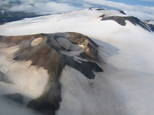
Increases in seismic activity have been detected previously at Takawangha volcano and other similar volcanoes, with no subsequent eruptions. We expect additional shallow seismicity and possibly other signs of unrest, such as gas emissions, elevated surface temperatures, and surface deformation to precede any future eruption, if one were to occur.
Takawangha volcano is monitored by local seismic and infrasound sensors, satellite data, and regional infrasound and lightning networks.
Source : AVO
Photo : Coombs, M. L.
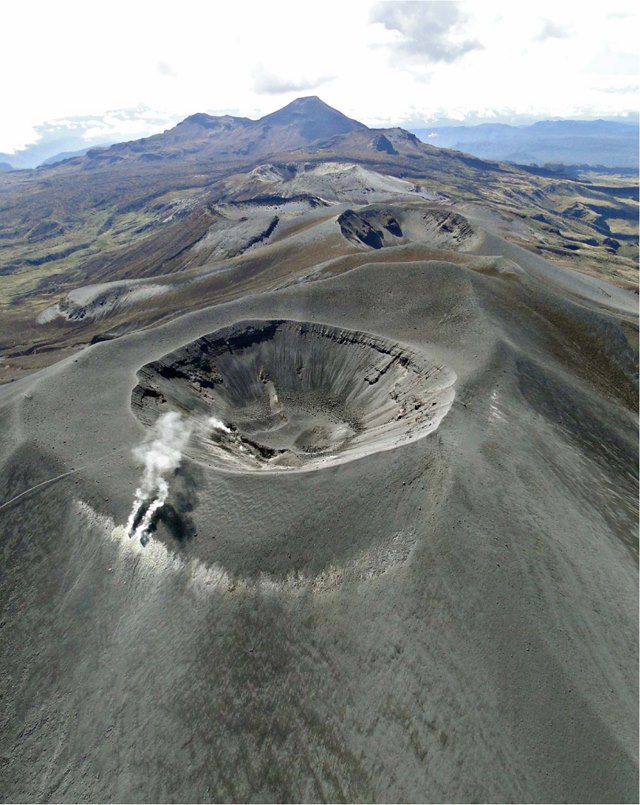
Colombia , Puracé – Los Coconucos Volcanic Range :
Weekly bulletin of activity of the Puracé volcano – Volcanic chain of Los Coconucos.
From the monitoring of the activity of the PURACÉ VOLCANO – VOLCANIC CHAIN OF LOS COCONUCOS, the MINISTRY OF MINES AND ENERGY through the COLOMBIAN GEOLOGICAL SERVICE (SGC) reports:
During the week of March 21 to 27, 2023, seismic activity showed stable behavior, with a total of 791 earthquakes, of which 54 were associated with processes
of rock fracturing and 737 with fluid dynamics in volcanic conduits. This process was accompanied by a deformation of the soil of the volcanic edifice associated with a process of inflation.
A degassing of the volcanic system was highlighted, with a white column oriented preferentially towards the Southeast and with a maximum flow of sulfur dioxide of 492 tons / day and a concentration of more than 10,000 ppm for carbon dioxide , consistent values in the degassing process of this volcanic system.
The other parameters measured and used for the diagnosis of volcanic activity did not show significant changes during the period evaluated. The volcanic activity continues to record variations which could evolve towards higher levels of activity.
The activity level of the volcano remains at YELLOW LEVEL (III): CHANGES IN THE BEHAVIOR OF VOLCANIC ACTIVITY.
Source et photo : SGC.
Kamchatka , Sheveluch :
VOLCANO OBSERVATORY NOTICE FOR AVIATION (VONA)
Issued: March 28 , 2023
Volcano: Sheveluch (CAVW #300270)
Current aviation colour code: ORANGE
Previous aviation colour code: orange
Source: KVERT
Notice Number: 2023-36
Volcano Location: N 56 deg 38 min E 161 deg 18 min
Area: Kamchatka, Russia
Summit Elevation: 3283 m (10768.24 ft), the dome elevation ~2500 m (8200 ft)
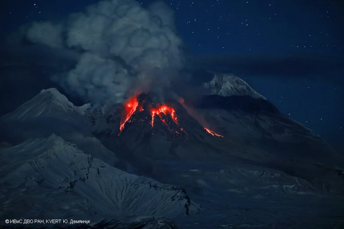
Volcanic Activity Summary:
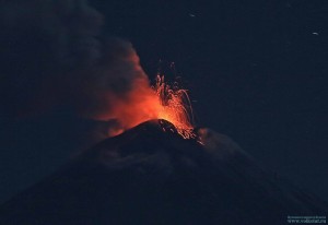
The growth of the lava dome continues, a strong fumarole activity, an incandescence of the lava dome, sometimes explosions, and hot avalanches accompanies this process. Video data by KVERT showed an a gas-steam plume contained some amount of ash is drifting to the east of the volcano.
The extrusive eruption of the volcano continues. Ash explosions up to 10-15 km (32,800-49,200 ft) a.s.l. could occur at any time. Ongoing activity could affect international and low-flying aircraft.
Volcanic cloud height:
3500 m (11480 ft) AMSL Time and method of ash plume/cloud height determination: 20230328/2120Z – Video data
Other volcanic cloud information:
Distance of ash plume/cloud of the volcano: 40 km (25 mi)
Direction of drift of ash plume/cloud of the volcano: E
Time and method of ash plume/cloud determination: 20230328/2120Z – Video data
Source : Kvert.
Photo : Yu. Demyanchuk, IVS FEB RAS, KVERT
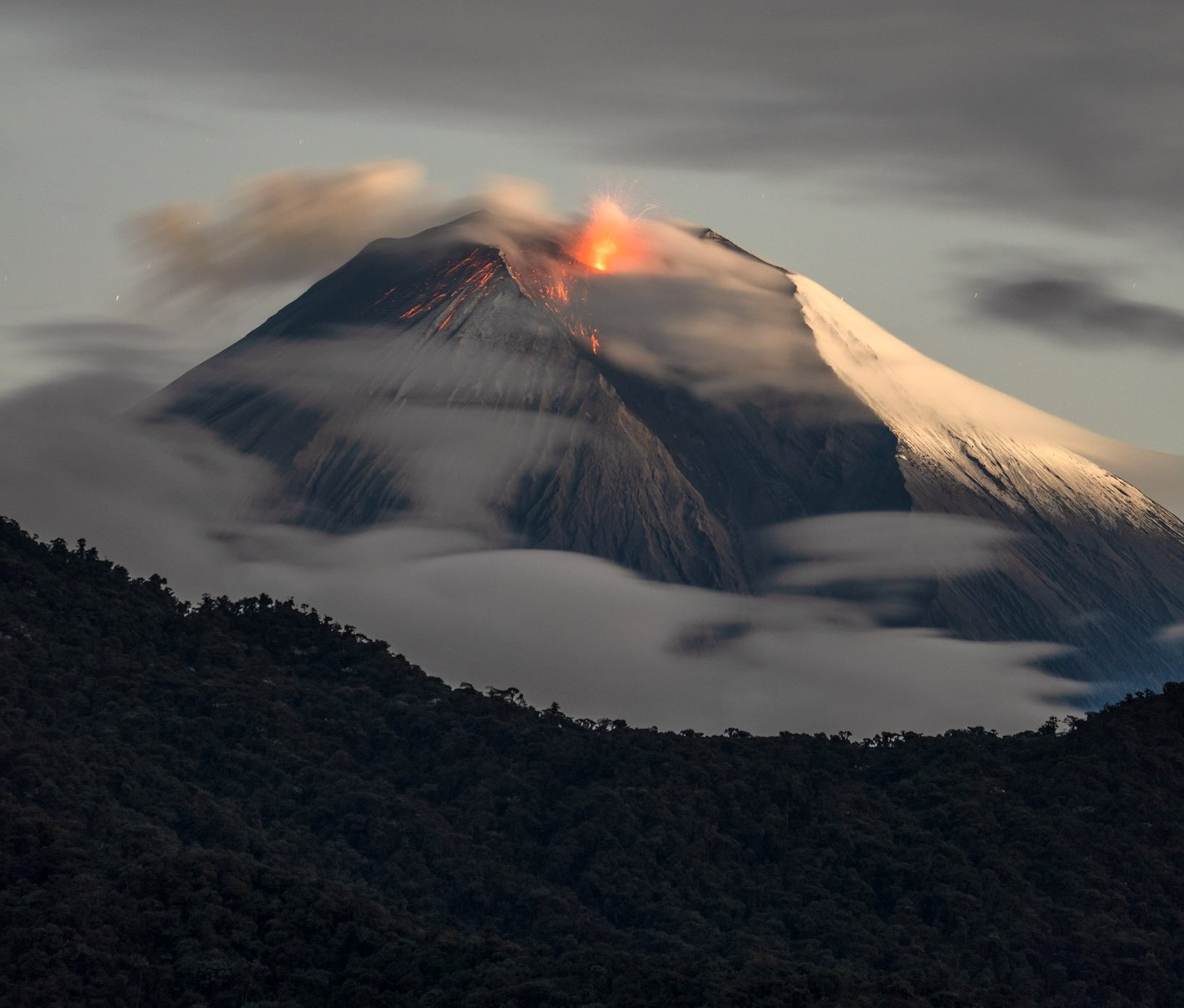
Ecuador , Sangay :
DAILY REPORT OF THE STATE OF SANGAY VOLCANO, Tuesday March 28, 2023.
Information Geophysical Institute – EPN.
Surface Activity Level: High, Surface Trend: Unchanged
Internal activity level: High, Internal trend: No change
Seismicity: From March 27, 2023, 11:00 a.m. to March 28, 2023, 11:00 a.m.:
Due to technical problems at the reference station, we only have 4 hours of data for seismicity statistics.
Explosion (EXP) 15
Emission Tremors (TREMI ) 8
Rains / Lahars:
Rains were recorded in the area during the morning today. **In the event of heavy rains, these could remobilize the accumulated materials, generating mudslides and debris that would descend the flanks of the volcano and flow into the adjacent rivers.**
Emission / Ash Column:
No shows were found. The Washington VAAC published 5 reports of ash emission, with a height of 1170 meters above crater level in a northwesterly direction. No fall reports were received in populated areas.
Other Monitoring Parameter:
MIROVA-MODIS records 1 high thermal alert (321 MW), while MIROVA-VIIRS records 1 high thermal alert (372 MW) and 1 moderate thermal alert in the last 24 hours.
Gas:
The MOUNTS system reported 370.7 tons of SO2, measured on 03/27/2023 at 12:59 TL.
Observation:
The area has remained completely cloudy for the past 24 hours, there are no surface level observations.
Alert level: Orange.
Source : IGEPN
Photo : Robinsky