June 17 , 2021 .
Italy , Stromboli :
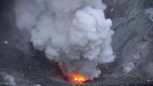
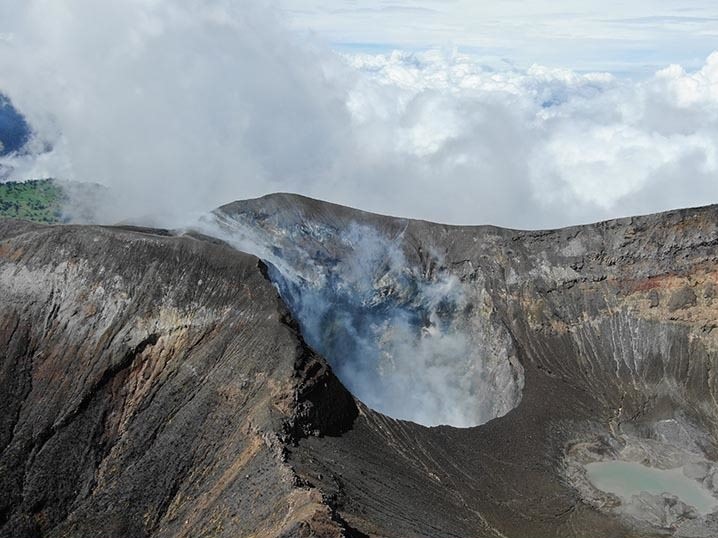
PRESS RELEASE ON THE ACTIVITY OF STROMBOLI, June 16, 2021, 16:10 (14:10 UTC).
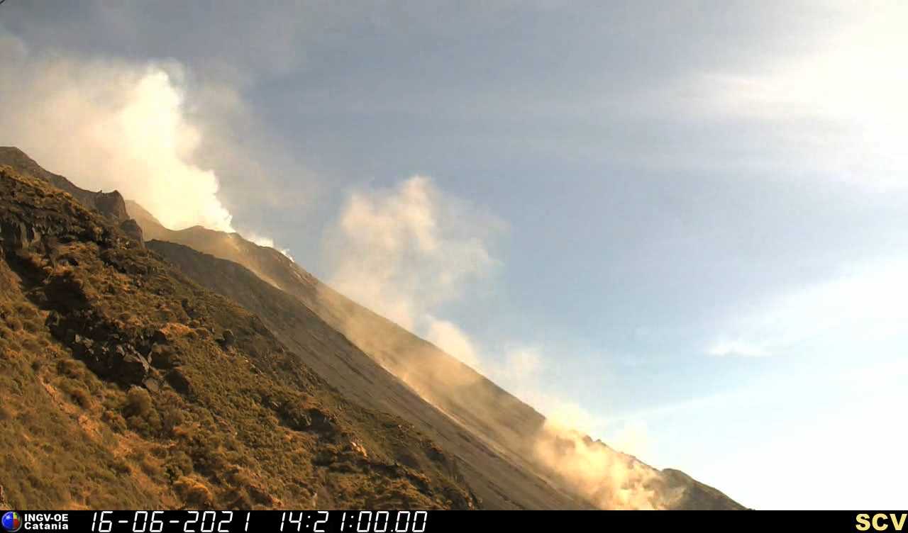
The National Institute of Geophysics and Volcanology, Osservatorio Etneo announces that at 13:28:50 in conjunction with an explosion at the Northeast Crater, at an altitude of about 600 m above sea level. a landslide was triggered which caused a rolling of material which detached from the previously mentioned altitude. The phenomenon lasted a few minutes.
From 13:28 UTC, a seismic signal lasting about 2 minutes was recorded, which can be associated with the landslide event observed by surveillance cameras.
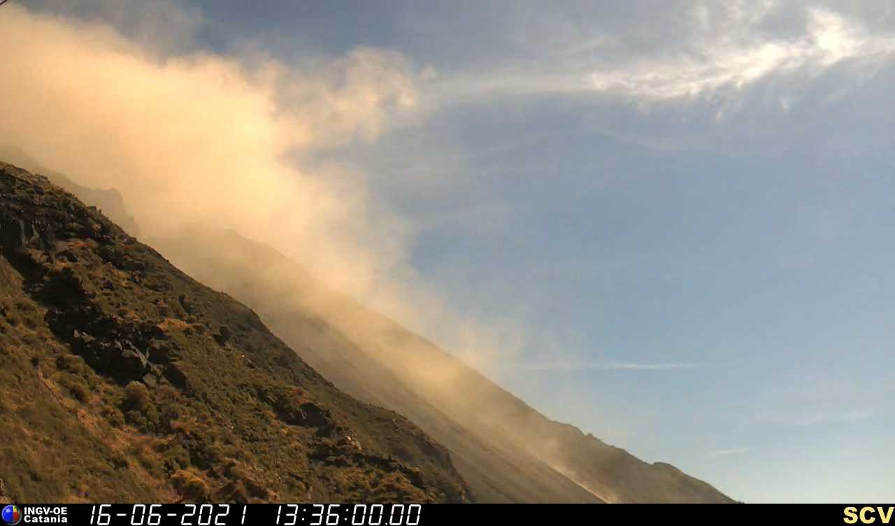
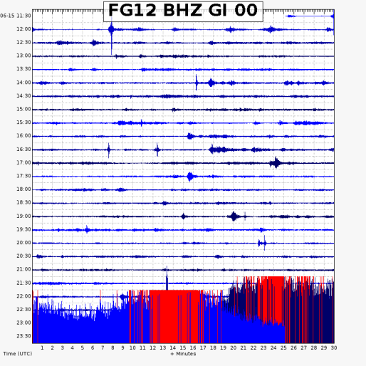
As for the amplitude of the tremor, from 22:05 UTC until 22:37 UTC yesterday, an increase was observed on medium-high values, then oscillated between medium-low and medium-high.
It is currently at medium to low levels. The frequency and magnitude of transients attributable to explosive events show a moderate increase. Amplitude is generally kept low with some medium-low amplitude events and some medium-high amplitude events. Currently, the amplitude is low.
The signals from the Stromboli deformation networks (tilt and GNSS) did not show significant variations.
PRESS RELEASE ON THE ACTIVITY OF STROMBOLI, June 16, 2021, 19:46 (17:46 UTC).
The National Institute of Geophysics and Volcanology, Osservatorio Etneo, announces that at 4:46 p.m. UTC a second landslide occurred along the Sciara del Fuoco at an altitude of about 450 m. The activity at the summit craters did not register any significant changes compared to the previous press release.
At 16:46 UTC, a low energy seismic signal was recorded, which may be associated with the landslide event observed through surveillance cameras. The trend of the mean amplitude of the volcanic tremor, however, does not show significant changes from that reported in the previous press release and shows medium-low values. The frequency and amplitude of transients attributable to explosive events do not show significant variations.
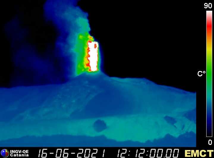
Extraordinary update of the CO2 flux of STR01 in the peripheral zone, and of the parameters of the thermal sinks of Stromboli.
The CO2 flux data, updated on the 14th, showed a clear increase which peaked on June 7th, reaching values of 178 g / m2 / d which are among the highest on record in recent years and significantly above the value. average of the CO2 flux of the last 5 years (106 g / m2 / d). In recent days, values seem to have stabilized around 150 g / m2 / d, while remaining high. The last thermal well sampling (June 07) confirms an increase in dissolved CO2, in particular at the Limoneto well, for several months.
The Helium isotopic ratio values show an increase in the last sampling, which is based on a general and significant increase in the last two months. The ratios are on average values (4.37 Ra).
The average daily flows of SO2 are placed at an average level with intra-day values at a medium-high level. Since the beginning of June, we have observed the stabilization of the increase recorded since the beginning of April.
The updated data shows that outgassing in the peripheral zone remains in general growth, probably fueled by increasing contributions of deep magmatic fluids that pressurize the surface system of the Stromboli volcano.
Further updates will be communicated shortly.
Source et photo: INGV.
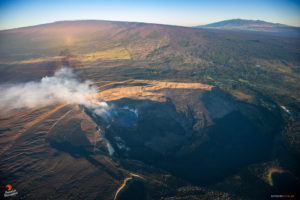
Italy / Sicily , Etna :
PRESS RELEASE ON ETNA’S ACTIVITY, June 16, 2021, 13:45 (11:45 UTC)
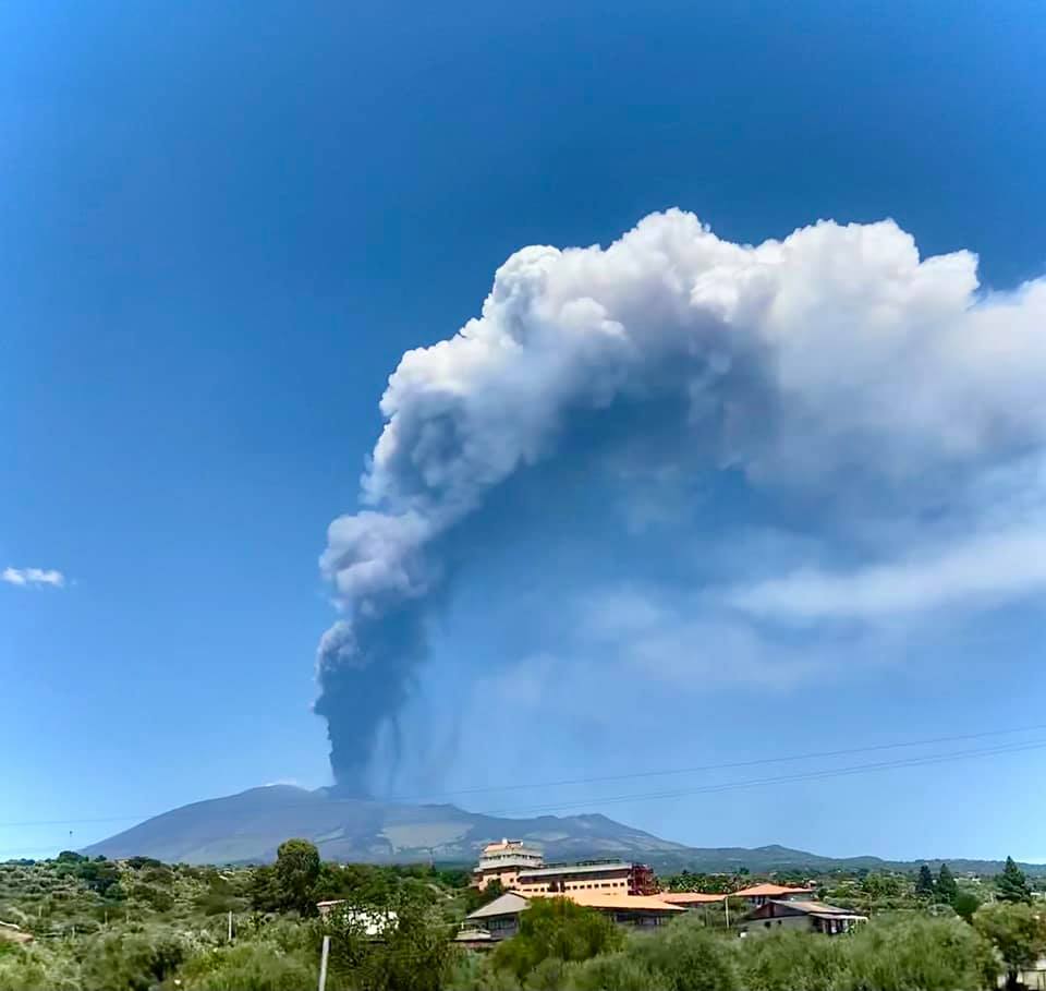
The National Institute of Geophysics and Volcanology, Osservatorio Etneo, announces that from approximately 11:32 UTC, a sudden increase in Strombolian activity is observed at the level of the Southeast Crater, which produces a continuous emission of ash that disperse in the summit region. The products of Strombolian activity exceed the edge of the crater falling on its sides.
The average amplitude of the volcanic tremor showed a sudden increase from 10:50 UTC reaching high values where it still remains.
The source centroid locations are in the Southeast Crater area at an altitude of 2900 m above sea level. Infrasound activity is increasing and is located in the Southeast Crater.
14:08 (12:08 UTC): Strombolian activity has shifted to the lava fountain stage. In addition, an overflow of lava is observed from the southern flank of the Southeast Crater which extends in a southwest direction. The average amplitude of the volcanic tremor and the infrasound activity reached very high values. The sources of tremors and infrasonic events are located in the Southeast Crater.
The stations upstream of the inclinometric network record modest variations in the signals.
PRESS RELEASE ON THE ACTIVITY OF ETNA, June 16, 2021, 15:20 (13:20 UTC).
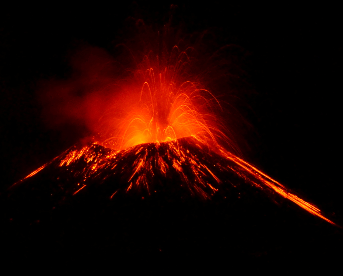
The National Institute of Geophysics and Volcanology, Osservatorio Etneo reports that from the images of the CCTV cameras, it is observed that the lava fountain of the Southeast Crater, reported in the previous press release, ceased at 12:50 p.m. UTC.
Regarding the lava flow, we observe that the one directed towards the South-West continues to be fed and there is also a second lava flow produced by a second overflow of the South-East Crater which propagates towards the Vallée del Bove.
As for the average amplitude of the volcanic tremor, after reaching the maximum value at 12:20 UTC, it underwent a rapid decrease, returning to the average level. Currently, this parameter shows a further downward trend. The center of gravity of volcanic tremor sources remains located in the Southeast Crater area at an altitude of about 2800 m above sea level. Infrasound activity has also experienced a rapid decrease: some localized events in the Southeast Crater area, with medium to high amplitude values, occurred.
The inclinometric network stations recorded modest variations in correspondence with the activity of the lava fountain which ends around 12:45 UTC. No significant change is observed in the GNSS data.
At 3:20 p.m. UTC, the resumption of Strombolian activity was recorded at the Southeast Crater. The effusive activity produced by the two overflows is terminated and the lava fronts are cooling.
Further updates will be communicated shortly.
Source : INGV.
Photos : INGV , Valeria Terranova , Casa di paglia Felcerossa / Permacultura sull’Etna
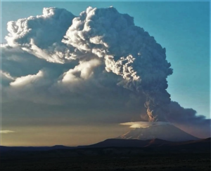
Costa Rica , Turrialba :
Daily Volcano Status Report, Date: June 13, 2021, Updated at: 10:37:00.
At 12:18 a.m. local time on June 13, 2021, an eruption was recorded on the Turrialba volcano, with a column that rose 300 meters above crater height and 3,640 meters above sea level . (11,939.2 feet).
Duration of activity: 2 minutes.
Seismic activity is similar, compared to yesterday.
At the time of this report, the winds were blowing from the southwest.
A small ash eruption was reported early in the morning. Traces of ash fall (accumulation <1 mm) were reported in Monte Calas and La Central. Strong smells of gas were reported at La Pastora early in the morning and rumbling was heard in various places around the volcano. No significant change was noted in the main monitoring parameters before or after the eruption.
Source : OVSICORI-UNA
Photo : G. Avard / Ovsicori.
Japan , Suwanosejima :
JMA reported that 28 explosions at Suwanosejima’s Ontake Crater produced eruption plumes that rose as high as 2.4 km above the crater rim during 4-11 June. Large volcanic bombs were ejected 500 m from the crater. Ashfall was reported in Toshima village (4 km SSW). Crater incandescence was visible nightly. The Alert Level remained at 2 and the public was warned to stay 1 km away from the crater.
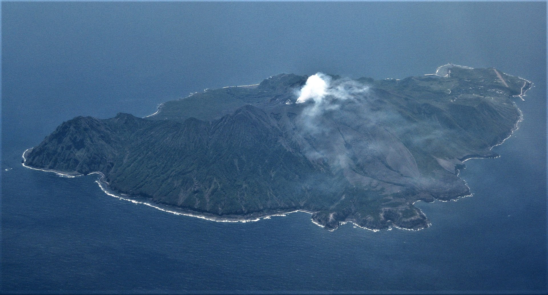
The 8-km-long, spindle-shaped island of Suwanosejima in the northern Ryukyu Islands consists of an andesitic stratovolcano with two historically active summit craters. The summit is truncated by a large breached crater extending to the sea on the east flank that was formed by edifice collapse. Suwanosejima, one of Japan’s most frequently active volcanoes, was in a state of intermittent strombolian activity from Otake, the NE summit crater, that began in 1949 and lasted until 1996, after which periods of inactivity lengthened. The largest historical eruption took place in 1813-14, when thick scoria deposits blanketed residential areas, and the SW crater produced two lava flows that reached the western coast. At the end of the eruption the summit of Otake collapsed forming a large debris avalanche and creating the horseshoe-shaped Sakuchi caldera, which extends to the eastern coast. The island remained uninhabited for about 70 years after the 1813-1814 eruption. Lava flows reached the eastern coast of the island in 1884. Only about 50 people live on the island.
Source : Japan Meteorological Agency (JMA) , GVP.
Photo : Ray Go.
Alaska , Semisopochnoi :
AVO/USGS Volcanic Activity Notice
Current Volcano Alert Level: ADVISORY
Previous Volcano Alert Level: WATCH
Current Aviation Color Code: YELLOW
Previous Aviation Color Code: ORANGE
Issued: Wednesday, June 16, 2021, 1:59 PM AKDT
Source: Alaska Volcano Observatory
Notice Number: 2021/A374
Location: N 51 deg 55 min E 179 deg 35 min
Elevation: 2625 ft (800 m)
Area: Aleutians
Volcanic Activity Summary:
No ash emissions or explosions from Semisopochnoi have been detected in satellite or infrasound data since May 30, and the level of seismic activity has been relatively low. Satellite views over the past few weeks have detected elevated surface temperatures, and sulfur dioxide emissions were observed on several occasions, indicating continued volcanic unrest, but no recent ash deposits have been observed. Because of the low level of seismicity and lack of significant explosive activity, AVO is lowering the Aviation Color Code and Volcano Alert Level to YELLOW/ADVISORY.
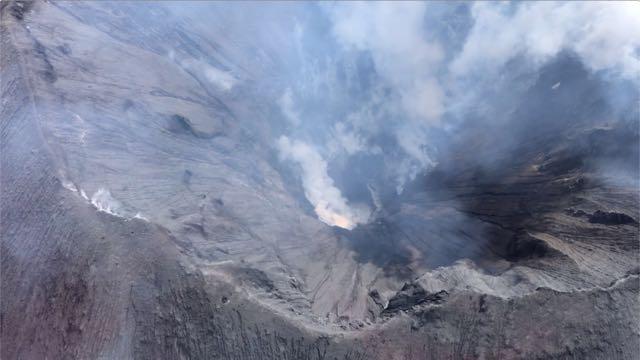
North Cerberus crater, June 6, 2021. Taken by Ellie Boyce during helicopter flight back to Steadfast from CERB. « There was less steam in the crater than during Hannah’s FLIR flight last week and we were able to see all the way to the bottom where there appears to still be a small lake in one side (in attached photo, just to the right of the brightest patch of steam). »
When occurring, small eruptions producing minor ash deposits within the vicinity of the active north crater of Mount Cerberus and ash clouds under 10,000 ft above sea level are typical of activity at Semisopochnoi.
Recent Observations:
[Volcanic cloud height] Unknown
[Other volcanic cloud information] Unknown
Hazard Analysis:
[Ash cloud] Explosions detected in infrasound data and confirmed in satellite imagery.
Remarks: Semisopochnoi is monitored by a local seismic and infrasound network, regional lightning and infrasound sensors, and satellite data.
Source : AVO.
Photo : Boyce, Ellie.
Guatemala , Fuego :
SPECIAL VOLCANOLOGICAL BULLETIN, June 15, 2021, 18:11 local time
DESCENT OF LAHARES IN THE RAVINES LAS LAJAS, JUTE
Heavy rainfall in the area of the volcanic complex, Fuego-Acatenango, is currently generating low to moderate category lahars in the Las Lajas, Jute ravines, tributaries of the Guacalate and Achíguate rivers. These descend with volcanic material, branches and tree trunks as well as blocks of 30 cm. 1.5 meters in diameter.
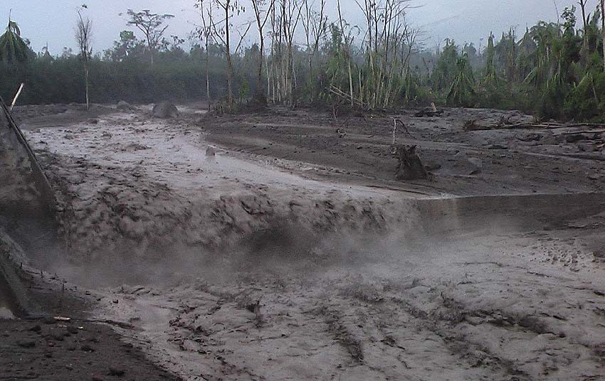
The rains of the last few days keep the volcanic deposits saturated with moisture, so they can generate lahars in other ravines around the volcanic complex, so proper precautions must be taken.
INSIVUMEH RECOMMENDATIONS
A SE-CONRED: Be aware of the development of lahars, in the ravines above and in the other ravines around the volcanic complex. Events similar to these are part of the post-eruption volcanic activity and daily activity, given the heavy rainfall in the volcanic area.
Source : Insivumeh.
Photos : Caroline Sarrazin , Insivumeh .