February 20 , 2023.
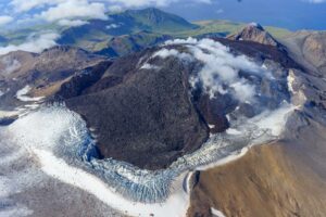
Ecuador , Cotopaxi :
Seismicity
From October 2022 to date, the seismicity shows a gradual increase in the number of daily events (LP, VT and VLP) and the energy released (Figure 1). Most of the energy manifests in the form of a tremor associated with the continuous emission of ash. Despite the fact that the values have increased over time, they are low compared to the most energetic activity recorded during the Cotopaxi eruption process in 2015.
On Tuesday, February 14, 2023, the maximum seismic energy values were reached, which was manifested at the surface level by an emission of ash of light to moderate load and which caused ash falls in the cities. closer to the volcano in Latacunga Township.
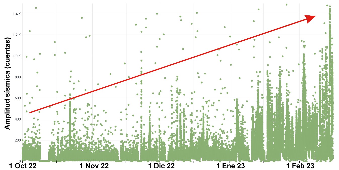
Seismic amplitude measured in balls recorded by the BREF station. Note that the energy released has gradually increased from October 2022 to the present day.
In addition, the seismic events located inside the volcano show larger and larger magnitudes.
Deformation
The internal processes of the volcano, such as the entry of new magma into the system, produce an increase in pressure and stress inside the volcanic edifice. These phenomena manifest themselves at the superficial level with the deformation of the ground, presenting displacements, which are only detectable by means of high precision instruments.
For the Cotopaxi volcano, the IG-EPN continuously processes positioning data using cGPS (Continuous Global Positioning Systems) instruments and high-precision inclinometers installed on the volcano. In addition, the analysis of movements is carried out by means of satellite radar images, processed with the InSAR (Synthetic Aperture Radar Interferometry) method.
Deformation or inflation on the western flank of the volcano has been slightly detected since August of the previous year and continues until now. The deformation observed by geodetic methods indicates that since the previous year the volcanic system has been disturbed by the entry of magma. This inflation presents a low magnitude speed of 8 mm/year observed by cGPS and 15 mm/year in the zone of greatest deformation according to InSAR; remaining stable and showing no signs of accelerating so far.
Thermography
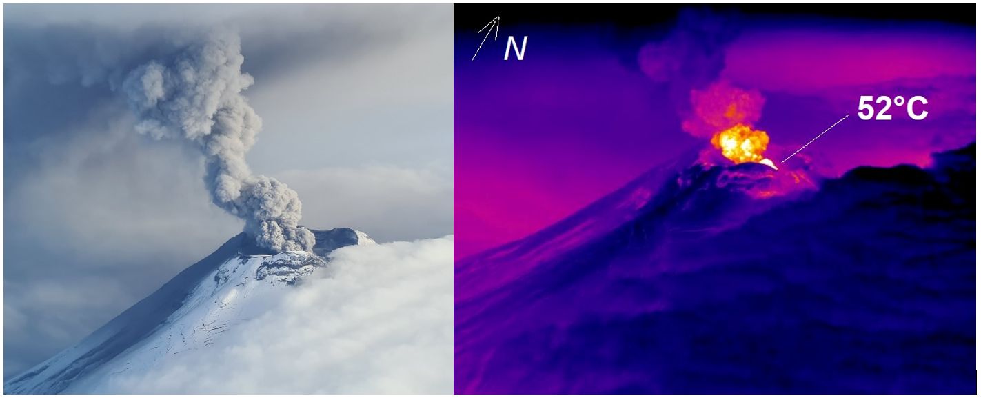
During the last flyby on February 2, 2023, new thermal sequences of the volcano were obtained. The temperatures obtained in the ash column are the highest (52°C) detected since the start of the eruption on October 21, 2022. No anomalies were observed in the fissures of the glacier, and the fumarolic fields have not their usual temperature (approx. 30°C) has not changed.
Degassing and sulfur dioxide (SO2) measurements
Since October 2022, there has been a gradual increase in the daily SO 2 flow values obtained from the DOAS instrument network, which intensify in December and slightly decrease since January 2023 The high values of SO 2 flux and the number of Valid measurements recorded since October 2022 are similar to those recorded during the 2015 eruption. These high values are also detected by the TROPOMI satellite sensor (Sentinel-5SP). This gas has been recorded in the atmosphere since October, reaching high values from late November to mid-January, after which values decrease (until February 14). By comparing the gas data with the maximum heights of the emission columns, it is verified that the DOAS network has better detection for the low-height columns, while the satellite better observes the SO 2 emissions associated with the high columns.
Short-term forecast of the activity of the Cotopaxi volcano
More likely: the moderate level of activity remains with eruptive columns <4 km above the crater and ashfall at the cantonal level (mainly Latacunga and Mejía), depending on the direction and speed of the wind. Small to moderate secondary lahars may be formed by the remobilization of recently deposited ash due to heavy rains or snowmelt in the upper areas of the volcano.
Source : IGEPN.
Photos : IGEPN
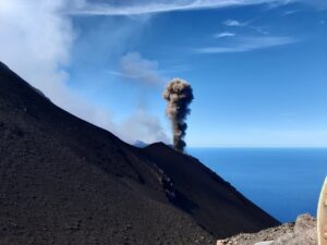
Chile , Lascar :
Volcanic Activity Report (RAV), Volcanological Observatory of the Southern Andes – Ovdas.
Seismic activity:
Over the past 24 hours, the seismic record continues to show volcano-tectonic activity (VT, associated with rock material rupture processes), as well as earthquakes associated with fluid movements, both from Long Period (LP) and Tornillos (TO) type. Some of the VT-type earthquakes contain features in their records that show the ability of the surface system to generate rock rupture (like a VT) and induce resonant vibrations in magmatic fluids like a type earthquake Tornillo, simultaneously.
Observations:
The source of the highest energy volcano-tectonic event was located 1 km in a South-South-East direction, with a depth of 1.9 km from the active crater.
A low intensity whitish degassing is observed until the afternoon of 02/17/2023. Subsequently, the volcano is observed with cloudiness.
Other Notes:
From 2 GNSS stations, which measure surface deformation, insignificant position variations have been observed in recent days. The distance between the stations presents variations of less than 1 cm, remaining at the annual average value. The greatest horizontal displacement is recorded at the PUNA station, south of the active crater, at a rate of 0.5 cm / month, in a West-North-West direction. On the other hand, the vertical displacements are weak, observing a beginning of negative trend vertically for the QUEB station, north of the crater, at a rate of 0.3 cm / month.
No new satellite thermal anomaly was detected (date of last image: February 18 (3)).
No new SO2 satellite anomaly was detected (date of last image: February 17 (4)).
The average SO2 flux was 237 t/d on February 16, measured with DOAS equipment.
Source : Sernageomin
Photo : Bas Wallet.
Colombia , Cumbal :
Cumbal Volcanic Complex Weekly Activity Bulletin
Cumbal Volcanic Complex activity continues at YELLOW LEVEL (III): CHANGES IN THE BEHAVIOR OF VOLCANIC ACTIVITY.
From monitoring the activity of the CUMBAL VOLCANIC COMPLEX (CVC), the COLOMBIAN GEOLOGICAL SERVICE (SGC) reports that:
In the period between February 7 and 13 and in low levels, an increase in seismic occurrence was recorded with an energy value similar to that reported the previous week. The predominance of earthquakes associated with rock fractures is maintained, which were located near the La Plazuela crater of the Volcanic Complex, with a very shallow depth and a maximum magnitude of 1.5.
The weather conditions were not favorable; however, it was possible to record, on some days of this week, columns of gas, white in color, low in height and lying towards the North under the action of the winds.
No significant variation was observed in the other geophysical and geochemical parameters.
The COLOMBIAN GEOLOGICAL SERVICE remains attentive to the evolution of the volcanic phenomenon and will continue to report the changes observed in a timely manner.
Source et photo : SGC.
Guatemala , Fuego :
Weather conditions: Clear weather
Wind: North-East.
Precipitation: 0.0 mm.
Activity:
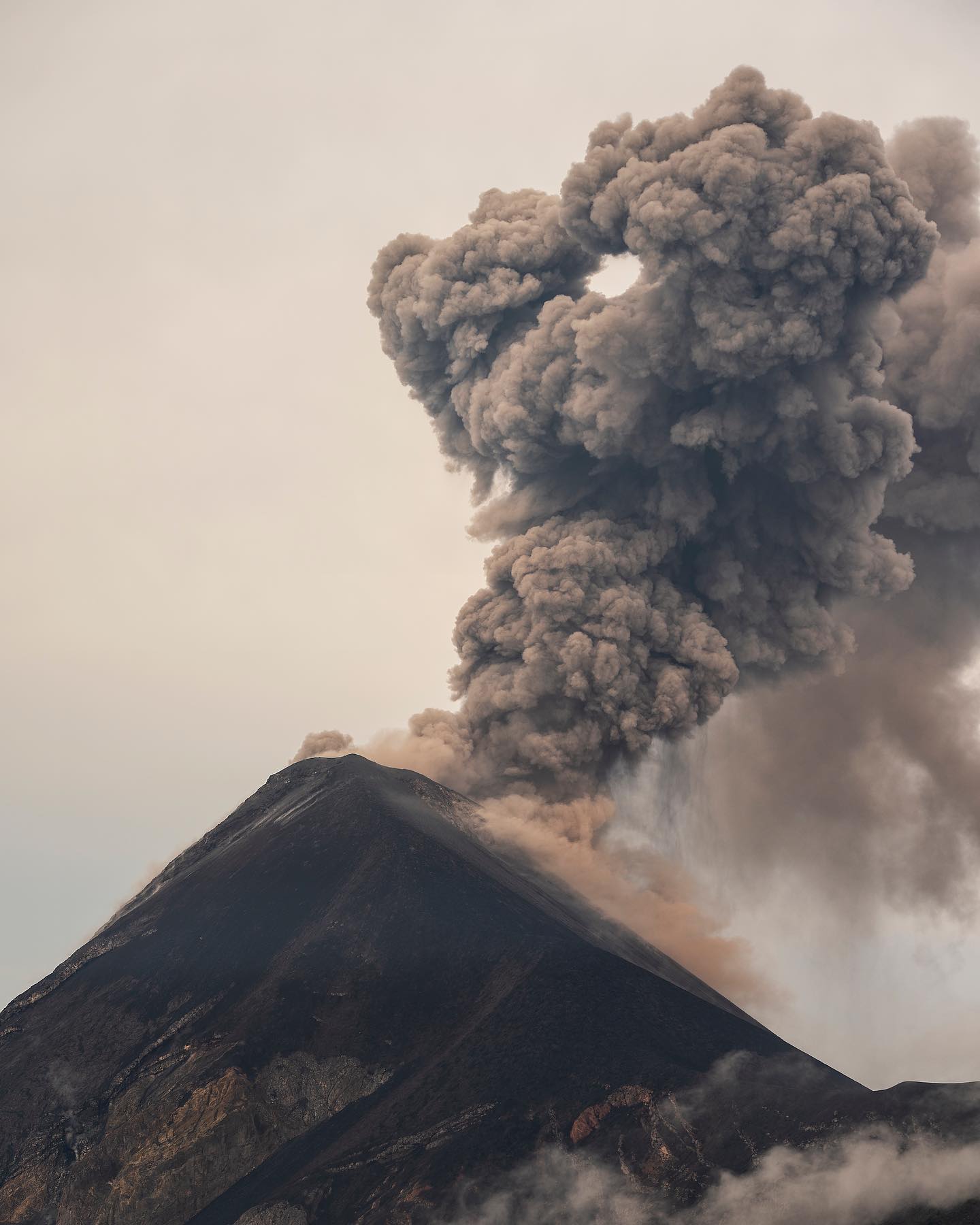
Hazy environment, activity was observed in the crater with weak to moderate explosions in the range of 6 to 8 per hour, expelling ash at a height of 4,500 to 4,800 meters above sea level (14,763 – 15,748 feet ) which disperse over 30 km in the direction West, South-West The strong wind maintains curtains of ash on the slopes of the volcano. The explosions generate rumblings and shock waves that vibrate the houses near the volcano. Weak to moderate avalanches were also observed in the ravines of Ceniza, Santa Teresa, Taniluya and Trinidad. Ash falls are reported at Panimache Morelia, Santa Sofía, Finca Palo Verde, Sangre de Cristo and others located to the west, and southwest of the Fuego volcano. With probabilities of ash fall in Santa Lucia and other places in the region.
Source : Insivumeh.
Photo : Diego Rizzo / @diegorizzophoto .
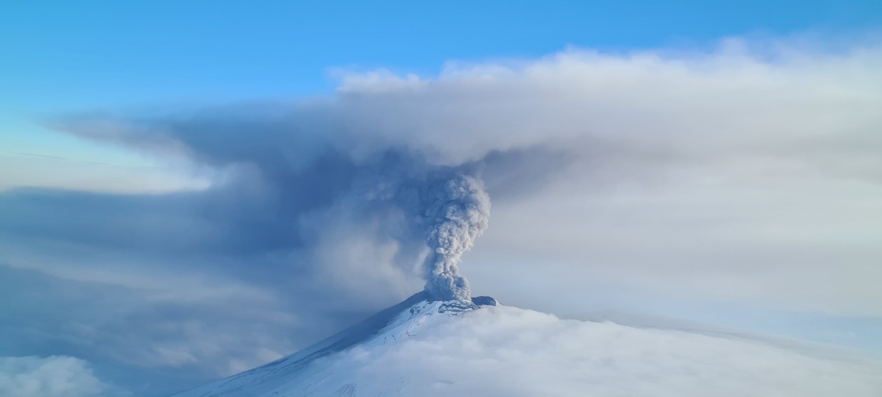
Mexico , Popocatepetl :
February 19, 11:00 a.m. (February 19, 5:00 p.m. GMT)
During the past 24 hours, according to the monitoring systems of the Popocatépetl volcano, 215 exhalations have been detected, accompanied by water vapor, volcanic gases and sometimes slight amounts of ash. Additionally, 30 minutes of tremor were also recorded.
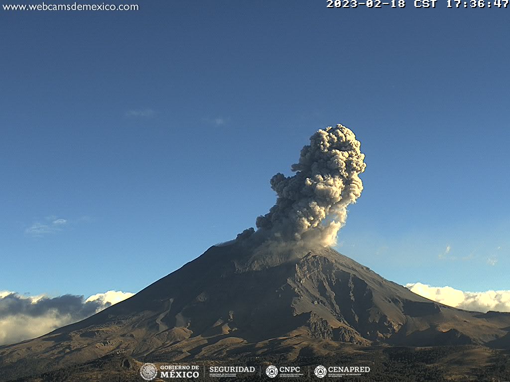
During the morning and at the time of this report, a constant emission of water vapor, volcanic gases and ash was observed in a northwesterly direction.
CENAPRED insistently reiterates the recommendation not to climb to the crater of the volcano because there is a possibility of explosions, as has been seen on several occasions in the past, involving the emission of incandescent fragments and in the event of heavy rains , move away from the bottom of the ravines due to the danger of mudslides and debris.
Source et photo : Cenapred.