October 05 2023.
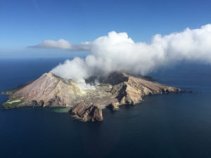
Alaska , Great Sitkin :
52°4’35 » N 176°6’39 » W,
Summit Elevation 5709 ft (1740 m)
Current Volcano Alert Level: WATCH
Current Aviation Color Code: ORANGE
Slow eruption of lava in the summit crater continues. Seismicity remains low with a few earthquakes detected over the past day. Clouds obscured satellite and web camera images, but a satellite radar image last night confirmed continued slow advance of the lava flow in the summit crater.
The current lava flow at Great Sitkin Volcano began erupting in July 2021. No explosive events have occurred since a single event in May 2021.
Local seismic and infrasound sensors, web cameras, regional infrasound and lightning networks, and satellite data are used to monitor the volcano.
AVO reported that slow lava effusion likely continued at Great Sitkin during 27 September-3 October, producing a thick flow in the summit crater that mainly expanded E. Seismicity was characterized as low with only a few daily earthquakes recorded by the seismic network. Weakly elevated surface temperatures were identified in satellite data during 2-3 October. Weather clouds sometimes obscured views. The Volcano Alert Level remained at Watch (the third level on a four-level scale) and the Aviation Color Code remained at Orange (the third color on a four-color scale).
Source : AVO , USGS
Photo : Loewen, Matt / Alaska Volcano Observatory / U.S. Geological Survey.
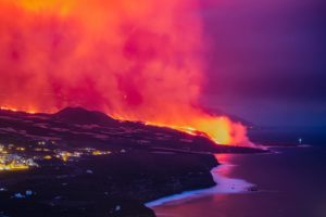
Italy , Stromboli :
Press release on Stromboli activity, October 4, 2023 10:09 (08:09 UTC).
The National Institute of Geophysics and Volcanology, Osservatorio Etneo, communicates that the analysis of images from the network of surveillance cameras has made it possible to observe that the lava overflow in the upper part of the Sciara del Fuoco is no longer fed and is cooling down. Ordinary Strombolian activity persists in the northern area of the crater, while projection activity has decreased in intensity. Ordinary Strombolian activity also continues in the South-Central crater area.
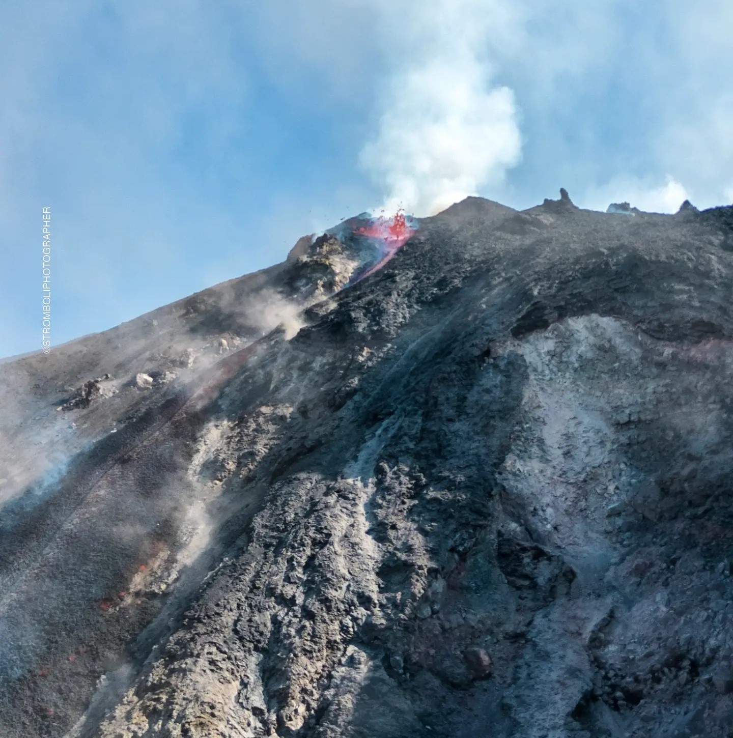
From the seismic point of view, during the last 24 hours the average amplitude of the volcanic tremor has fluctuated between medium to high values and since late yesterday evening it has remained exclusively at the medium level. No significant changes were reported in the frequency of occurrence and amplitude of explosion earthquakes. Ground deformations measured by GNSS and inclinometer networks still do not show significant variations.
Further updates will be communicated shortly.
Source : INGV
Photo : Stromboli stati d’animo.
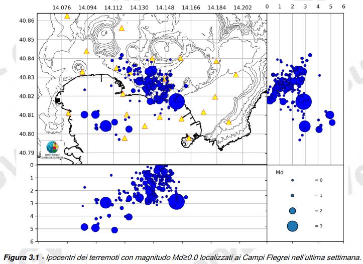
Italy , Campi Flegrei :
Weekly bulletin, from September 25, 2023 to October 1, 2023. (Issue date October 3, 2023)
SUMMARY STATEMENT OF ACTIVITY
1) SISMOLOGY: In the week from September 25 to October 1, 2023, in the Campi Flegrei area, 270 earthquakes of magnitude Md≥0.0 (Mdmax=4.2±0.3) were located.
2) DEFORMATIONS: From January 2023, the average value of the lifting speed in the maximum deformation zone is approximately 15±3 mm/month. Over the past two weeks there has been a possible increase in lifting speed, the actual trend of which can be assessed using data from the coming weeks. The lift recorded at the RITE GNSS station is approximately 25.5 cm since January 2022.
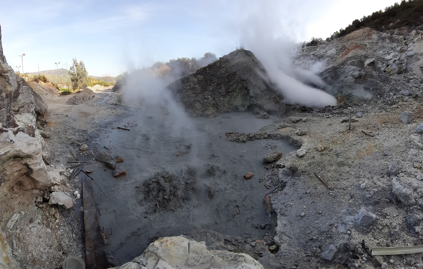
3) GEOCHEMISTRY: There are no significant variations in the geochemical parameters monitored in the reference period compared to the already known trends of increased flow rates and heating of the hydrothermal system. The temperature sensor installed in a fumarole emission 5 meters from the main Pisciarelli fumarole showed an average value of ~95°C, condensation temperature of the fumarole liquid. The absence of liquid in the Pisciarelli basin remains, indicative of a reduced supply of fumarolic condensates.
SEISMOLOGY
In the week from September 25 to October 1, 2023, in the Campi Flegrei area, 270 earthquakes of magnitude Md≥0.0 (Mdmax=4.2±0.3) were located.
196 earthquakes were recorded during 3 seismic swarms:
● the first, from 03:06 UTC on 09/26/2023, composed of 88 earthquakes with Md≥0.0 (Mdmax=4.2±0.3) occurring in the Solfatare area, Bagnoli , Gulf of Pozzuoli;
● the second, from 7:28 p.m. UTC on 09/27/2023, composed of 89 earthquakes with Md≥0.0 (Mdmax=2.1±0.3) occurring in the Solfatara, Accademia area;
● the third, from 9:25 p.m. UTC on 09/29/2023, composed of 19 earthquakes with Md≥0.0 (Mdmax=2.5±0.3) occurring in the Pozzuoli area, Gulf of Pozzuoli.
GROUND DEFORMATIONS
Since January 2023, the average value of lifting speed in the maximum deformation zone is approximately 15±3 mm/month, with slight reductions, such as that recorded from the end of May to the end of June 2023.
Over the past two weeks, along with greater seismic activity in the area, an increase in the rate of deformation has been recorded. This variation, the real trend of which can be assessed with data from the coming weeks, seems to affect both the vertical (altitude variations of the RITE station) and planimetric (length variations of the ACAE) components.
Source : INGV.
Photos : Tullio Ricci,, ingv
Japan , Suwanosejima :
JMA reported that the eruption at Suwanosejima’s Ontake Crater continued during 25 September-2 October. Eruptive events on 25, 27, and 30 September, and 1-2 October, produced ash plumes that rose as high as 1.3 km above the crater rim and ejected blocks as far as 300 m from the crater. Crater incandescence was visible nightly. Ash emissions were continuous from 05h10 to 05h55 on 1 October. The Alert Level remained at 2 (on a 5-level scale) and the public was warned to stay at least 1 km away from the crater.
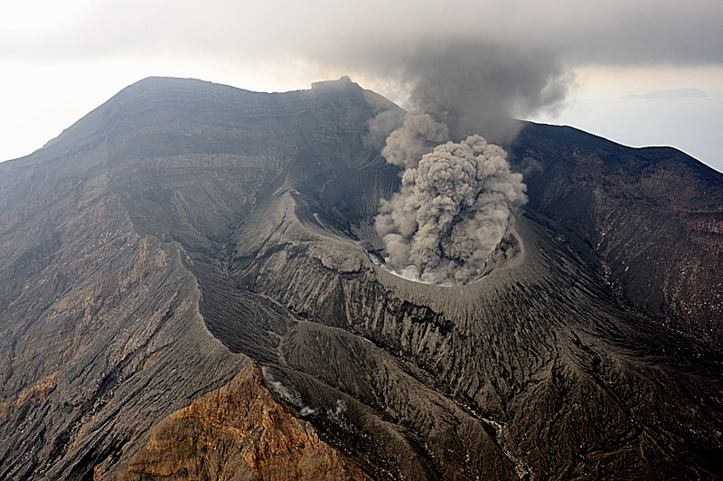
The 8-km-long island of Suwanosejima in the northern Ryukyu Islands consists of an andesitic stratovolcano with two historically active summit craters. The summit is truncated by a large breached crater extending to the sea on the east flank that was formed by edifice collapse. One of Japan’s most frequently active volcanoes, it was in a state of intermittent Strombolian activity from Otake, the NE summit crater, between 1949 and 1996, after which periods of inactivity lengthened. The largest recorded eruption took place in 1813-14, when thick scoria deposits blanketed residential areas, and the SW crater produced two lava flows that reached the western coast. At the end of the eruption the summit of Otake collapsed, forming a large debris avalanche and creating the open Sakuchi caldera, which extends to the eastern coast. The island remained uninhabited for about 70 years after the 1813-1814 eruption. Lava flows reached the eastern coast of the island in 1884. Only about 50 people live on the island.
Source : GVP , JMA
Photo : N. Geshi. Geological Survey of Japan, H.Seo
Colombia , Chiles / Cerro Negro :
Weekly activity bulletin of the Chiles and Cerro Negro Volcanic Complex (CVCCN)
Regarding the monitoring of the activity of the CHILES AND CERRO NEGRO VOLCANOES, the MINISTRY OF MINES AND ENERGY, through the COLOMBIAN GEOLOGICAL SERVICE (SGC), reports that:
For the period from September 26 to October 2, 2023 and compared to previous weeks, seismic activity showed similar values, both in occurrence and in energy released.
The predominance of earthquakes associated with rock fracturing continued. Most of these earthquakes occurred south of Chiles Volcano, at epicentral distances of up to 8 km, with depths less than 9 km from its summit height (reference level greater than 4,700 m altitude). No felt earthquakes were reported. The deformation was maintained in several sectors of the volcanic edifice detected instrumentally by sensors installed on the volcanoes as well as by satellite sensors.
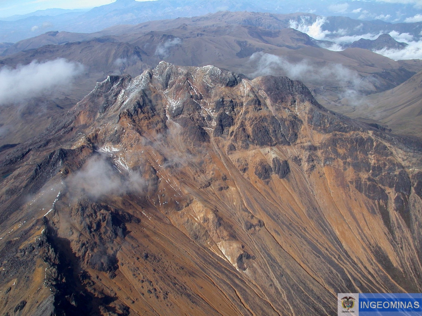
The evolution of the activity of the CVCCN continues based on the different manifestations recorded, which respond to processes derived from a complex interaction between the magmatic, hydrothermal system and the geological faults of the area, which can trigger the appearance energetic earthquakes that are felt. by residents in the area of influence of the CVCCN, as well as generating instability on slopes, landslides and structural damage to buildings, access roads, bridges, etc. These are aspects that must continue to be taken into account by the authorities and the communities that reside in the zone of influence of these volcanoes.
Source : SGC
Photo : Ingeominas