December 11 , 2022.
Chile , Lascar :
Special Report on Volcanic Activity (REAV), Antofagasta region, Lascar volcano, December 10, 2022, 1:18 p.m. local time (mainland Chile).
The National Service of Geology and Mines of Chile (Sernageomin) publishes the following PRELIMINARY information, obtained through the monitoring equipment of the National Volcanic Monitoring Network (RNVV), processed and analyzed at the Volcanological Observatory of the Southern Andes ( Ovdas):
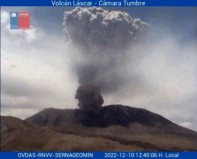
On Saturday December 10, 2022, at 12:36 local time (15:36 UTC), the monitoring stations installed near the Lascar volcano recorded an earthquake associated with fluid dynamics in the volcanic system (long period type).
The characteristics of earthquakes after their analysis are as follows:
ORIGINAL TIME: 12:36 local time (15:36 UTC)
REDUCED DISPLACEMENT: 320 (cm*cm)
The characteristics of the associated surface activity are as follows:
MAXIMUM COLUMN HEIGHT: Greater than the detection limit of the camera.
DIRECTION OF DISPERSION: Southwest (SW)
COMMENTS:
Generation of eruptive column with a high content of pyroclasts approximately 6000 m above the level of the crater, dispersed towards the South-West. This explosion generated short distance pyroclastic flows on the North and South-East flanks.
The volcanic technical alert remains at the Green level.
Special Report on Volcanic Activity (REAV), Antofagasta Region, Lascar Volcano, December 10, 2022, 5:30 p.m. local time (mainland Chile).
The National Service of Geology and Mines of Chile (Sernageomin) publishes the following PRELIMINARY information, obtained through the monitoring equipment of the National Volcanic Monitoring Network (RNVV), processed and analyzed at the Volcanological Observatory of the Southern Andes ( Ovdas):

On Saturday December 10, 2022, at 12:36 local time (15:36 UTC), an explosive event was recorded on the Lascar volcano, in connection with an energetic seismic signal of 320 cm2, which generated an eruptive column on the surface which , according to the satellites reached an approximate altitude of 6000 m above the level of the crater. This one dispersed towards the southwest and generated pyroclastic flows around the crater. Due to the characteristics of the recorded event and with the instrumental historical monitoring, it is not possible to rule out the possibility of the occurrence of other events similar to those recorded. For the above, the alert level is raised to the Yellow level and is considered as a zone of possible assignment an area with a radius of 3 km around the active crater of the volcano.
The volcanic technical alert has been raised to the Yellow level.
Sources : Sernageomin.
Photos : Sernageomin , terremotos y desastres
Hawaii , Mauna Loa :
HVO/USGS Volcanic Activity Notice
Current Volcano Alert Level: WATCH
Previous Volcano Alert Level: WARNING
Current Aviation Color Code: ORANGE
Issued: Saturday, December 10, 2022, 2:35 PM HST
Source: Hawaiian Volcano Observatory
Notice Number: 2022/H650
Location: N 19 deg 28 min W 155 deg 36 min
Elevation: 13681 ft (4170 m)
Area: Hawaii
Aerial image of fissure 3 erupting on Mauna Loa’s Northeast Rift Zone the morning of December 10, 2022. The eruption output has greatly decreased over the past two days and within the fissure 3 cone, geologists noted a small lava pond rather than a lava fountain.
Volcanic Activity Summary:
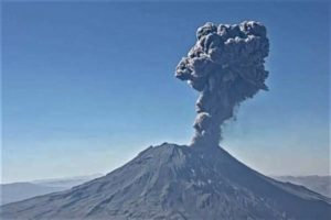
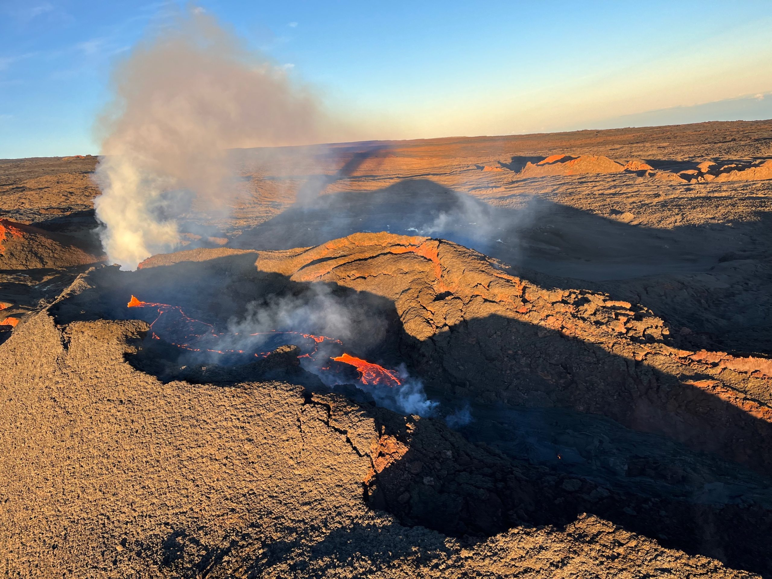
Lava eruption from fissure 3 (F3) on the Northeast Rift Zone of Mauna Loa continues but with greatly reduced lava output and volcanic gas emissions. Most lava is confined to the vent in a small pond. The short lava flows active about 1.5 miles (2.4 km) from the vent yesterday have stalled.
The flow front in the Humu’ula Saddle region has stagnated 1.9 miles (3 km) from the Daniel K. Inouye Highway (Saddle Road) and is no longer a threat.
High eruption rates will not resume based on past eruptive behavior and current behavior suggests that the eruption may end soon. However, an inflationary trend of Mauna Loa’s summit is accompanying the decreased activity and there is a small possibility that the eruption could continue at very low eruptive rates.
For these reasons, HVO is reducing the volcano alert level from WARNING to WATCH, reflecting the limited hazards associated with the current activity. The aviation color code will remain at ORANGE, reflecting the uncertainty of continuing eruptive activity and the possibility of volcanic ash emissions.
HVO scientists continue to closely monitor Mauna Loa and the active eruption site for any indication of changes to activity.
The Federal Aviation Administration temporary flight restriction remains in place, extending from the surface to 1500 feet (457 meters) above ground level in the eruption area.
Source : HVO
Photo : USGS / K. Mulliken.
Italy , Stromboli :
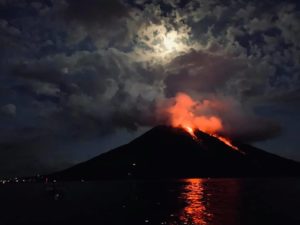
Statement on Stromboli activity, 09 December 2022 19:32 (18:32 UTC).
The National Institute of Geophysics and Volcanology, Osservatorio Etneo, communicates that according to the observations made by the staff of the I.N.G.V. ‘O.E. of Catania present on Stromboli, a continuous Strombolian activity is detected in the northern sector of the crater terrace, as well as a strong regression of effusive activity.
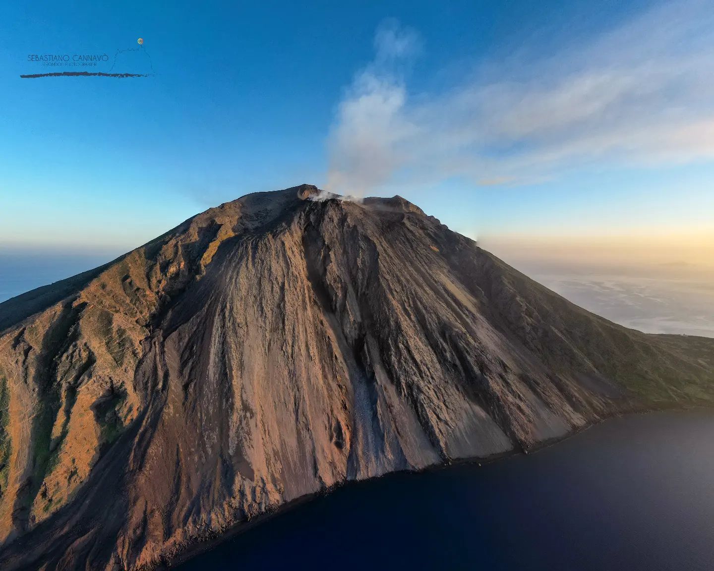
From a seismic point of view, during the last 24 hours, the average amplitude of the volcanic tremor has shown no variation, always remaining, so far, in the range of average values.
With regard to ground deformations, the signals from the Tilt-meter and GNSS networks have not shown any significant variations over the past 24 hours.
Further updates will be communicated soon.
Source : INGV.
Photo : Stromboli Stati d’animo / Sebastiano Cannavo.
Philippines , Mayon :
MAYON VOLCANO BULLETIN 11 December 2022 8:00 AM
In the past 24-hour period, the Mayon Volcano Network recorded one (1) rockfall event. Moderate emission of white steam-laden plumes that crept downslope and rose 300 meters towards south-southwest, south-southeast, east-southeast, and east-northeast was observed. Faint crater glow from the summit could be observed at night. Sulfur dioxide (SO2) emission was last measured at an average of 477 tonnes/day on 08 December 2022. Based on ground deformation parameters from EDM, Precise Leveling, electronic tilt, and continuous GPS monitoring, Mayon Volcano has been slightly inflated since 2020.
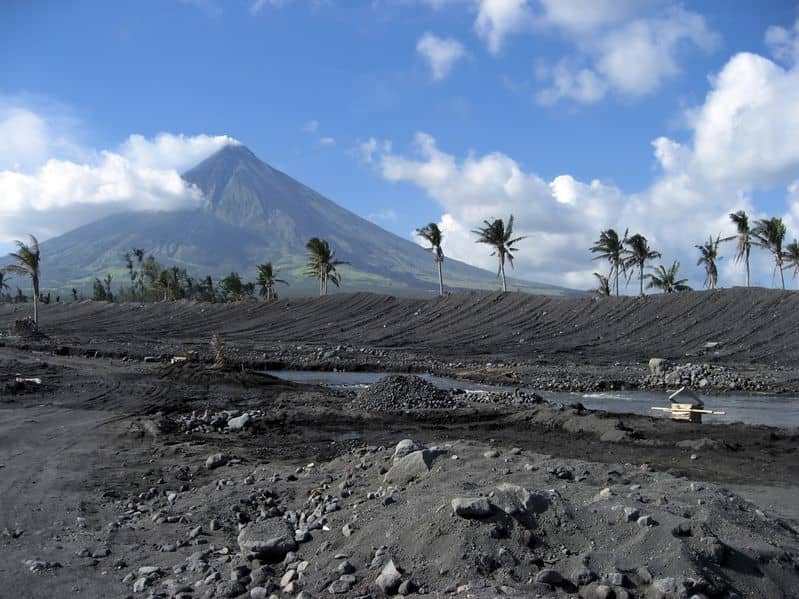
Alert Level 2 (Increased Unrest) prevails over Mayon Volcano. The public is reminded that there is current unrest driven by shallow magmatic processes that could eventually lead to phreatic eruptions or even precede hazardous magmatic eruptions. Entry into the six (6) kilometer-radius Permanent Danger Zone (PDZ) is strictly prohibited to minimize risks from sudden explosions, rockfalls, and landslides. In case of ash fall events that may affect communities downwind of Mayon’s crater, people should cover their nose and mouth with a damp, clean cloth, or dust mask. Civil aviation authorities must also advise pilots to avoid flying close to the volcano’s summit as ash from any sudden eruption can be hazardous to aircraft.
DOST-PHIVOLCS maintains close monitoring of Mayon Volcano and any new development will be communicated to all concerned stakeholders.
Source et photo : Phivolcs
Colombia , Nevado del Ruiz :
Bulletin of activity level of the Nevado del Ruiz volcano.
The activity level continues at the yellow activity level or (III): changes in the behavior of volcanic activity.
Regarding the monitoring of the activity of the Nevado del Ruiz volcano, the COLOMBIAN GEOLOGICAL SERVICE reports that:
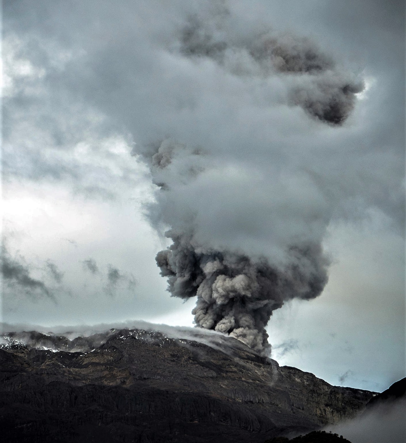
Seismic activity related to fluid dynamics within volcanic conduits increased compared to the previous week. The continuous volcanic tremor signal with low to moderate energy levels that has been recorded since December 2 stands out. According to the images captured by the cameras installed in the volcano area and by the report of the staff of the National Natural Park of Los Nevados, several pulsatile emissions of gas and ash associated with some of the seismic signals have been confirmed. There was also a report of observation from several municipalities of Tolima and Caldas of the continuous emission of ash that has been occurring since the same day.
Seismic activity associated with rock fracturing decreased the number of recorded earthquakes and maintained similar levels in released seismic energy compared to the previous week. The earthquakes were located mainly in the southeast, northeast and southwest sectors of the volcano and in the Arenas crater. The depth of the earthquakes ranged from about 0.7 to 9.0 km. The maximum magnitude observed during the week was 1.6 ML (Local Magnitude) corresponding to the earthquake recorded on December 1 at 11:39 p.m. (local time), located about 3.0 km southeast of the crater, at a depth 3.6 km.
Deformation of the volcanic surface continues to show minor changes.
Source : SGC.
Photo : Álex Palacio