August 01 , 2023.
Peru , Ubinas :
Analysis period: July 24-30, 2023 Arequipa, July 31, 2023.
Alert level: ORANGE
The Geophysical Institute of Peru (IGP) reports that the eruptive processes of the Ubinas volcano (Moquegua region) maintain moderate levels. During this period, 5 volcanic explosions as well as ash emissions which reached up to 2500 m above the summit of the volcano were recorded. For this, it is suggested to the authorities to maintain the volcanic alert level at the Orange level.
During the analysis period, the occurrence of 60 volcano-tectonic (VT) type earthquakes was detected, associated with rock breaking processes that occur inside the volcano. In addition, 117 long-period (LP) type seismic signals were recorded, associated with the movements of volcanic fluids (gas and magma), with a maximum energy of 2.5 Megajoules. Finally, it has been identified a duration of 5 hours / day of seismic recordings in relation to ash emissions with a maximum of 13 hours, recorded on July 27.
Surveillance cameras identified volcanic explosions and columns of gas and ash that reached heights of 2500 m above the summit of the volcano, which were dispersed mainly to the southeast, east and Northeast of the Ubinas volcano with a radius of 40 km (districts of Ubinas, Matalaque, Lloque, Chojata, Yunga and Ichuna). On July 29, following a strong explosion at 9:57 a.m., significant ash fall was reported in the districts of Ubinas and Malataque. On the other hand, the monitoring of the deformation of the volcanic structure, show variations of less than 7 mm of displacement (slight tendency to inflation). Satellite monitoring showed a 2 MW thermal anomaly in the Ubinas crater.
RECOMMENDATIONS
Keep the Volcanic Alert Level at ORANGE.
Source : Cenvul
Photo : Ingemmet
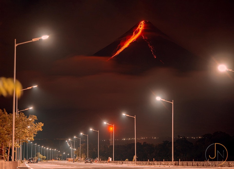
Philippines , Mayon :
MAYON VOLCANO BULLETIN 01 August 2023 8:00 AM
Beginning at approximately 6:00 PM yesterday, 31 July 2023, eruptive activity at Mayon became dominated by phases of intermittent ashing alongside increases in the apparent rates of lava effusion from the summit crater. The ashing phases consisted of discrete events recorded as low-frequency volcanic earthquakes or LFVQs of typical 30 seconds duration based on seismic and infrasound signal. Short, 100-meter gray ash plumes were produced that drifted to the general northeast. Shortly after ashing commenced, new lava began effusing rapidly from the crater and fed the established lava flows on the Bonga (southeastern), Mi-isi (south), and Basud (eastern) gullies as welll as frequent rockfall downslope. These lava flows have advanced respectively to 2.8 kilometers, 3.4 kilometers, and 600 meters from the crater. In sum, a total of two hundred fifty-eight (258) volcanic earthquakes including one (1) tremor event having duration of 1 minute and 30 seconds and two hundred fifty-six (256) LFVQs of fifty-seven (57) ashing events, and one hundred (100) rockfall events were recorded by the Mayon Volcano Network over the past 24-hour period.
Volcanic sulfur dioxide (SO2) emission averaged 2,325 tonnes/day on 31 July 2023. Short-term observations from electronic tilt and GPS monitoring indicate a deflation of the eastern lower flanks in early July 2023 and inflation of the northwest middle flanks in the third week of July 2023. Longer-term ground deformation parameters from EDM, precise leveling, continuous GPS, and electronic tilt monitoring indicate that Mayon is still generally inflated relative to baseline levels.
Alert Level 3 is maintained over Mayon Volcano, which means that it is currently in a relatively high level of unrest and hazardous eruption within weeks or even days could still be possible.
Source: Phivolcs
Photo : JN
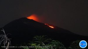
Indonesia , Ili Lewotolok :
An eruption of G. Ili Lewotolok occurred on Monday, July 31, 2023 at 2:21 p.m. WITA with an ash column height observed at ± 500 m above the summit (± 1923 m above sea level) . The ash column was observed to be gray with moderate intensity, oriented to the west. This eruption was recorded on a seismograph with a maximum amplitude of 34.3 mm and a duration of 121 seconds.
VOLCANO OBSERVATORY NOTICE FOR AVIATION – VONA
Issued : July 31 , 2023
Volcano : Ili Lewotolok (264230)
Current Aviation Colour Code : ORANGE
Previous Aviation Colour Code : orange
Source : Ili Lewotolok Volcano Observatory
Notice Number : 2023LEW042
Volcano Location : S 08 deg 16 min 19 sec E 123 deg 30 min 18 sec
Area : East Nusa Tenggara, Indonesia
Summit Elevation : 4554 FT (1423 M)
Volcanic Activity Summary :
Eruption with volcanic ash cloud at 06h21 UTC (14h21 local).
Volcanic Cloud Height :
Best estimate of ash-cloud top is around 6154 FT (1923 M) above sea level or 1600 FT (500 M) above summit. May be higher than what can be observed clearly. Source of height data: ground observer.
Other Volcanic Cloud Information :
Ash cloud moving to west. Volcanic ash is observed to be gray. The intensity of volcanic ash is observed to be medium.
Remarks :
Eruption recorded on seismogram with maximum amplitude 34.3 mm and maximum duration 121 second.
Source and photo : Magma Indonésie
La Réunion , Piton de la Fournaise :
Press release from the Paris Institute of Earth Physics, Piton de la Fournaise Volcanological Observatory, July 31, 2023 – 10:15 a.m. – 06:15 a.m. UTC
Ongoing eruption
The eruption started on July 02, 2023, around 08:30 local time continues. The amplitude of the volcanic tremor (indicator of an emission of lava and gas on the surface) remains very low compared to the start of the eruption and is still slowly decreasing.
Over the past 24 hours, the cloud mass present regularly on the eruptive site as well as the presence of numerous lava tunnels have not allowed the estimation of flows by satellite method by the HOTVOLC platform (OPGC – Clermont Auvergne University).
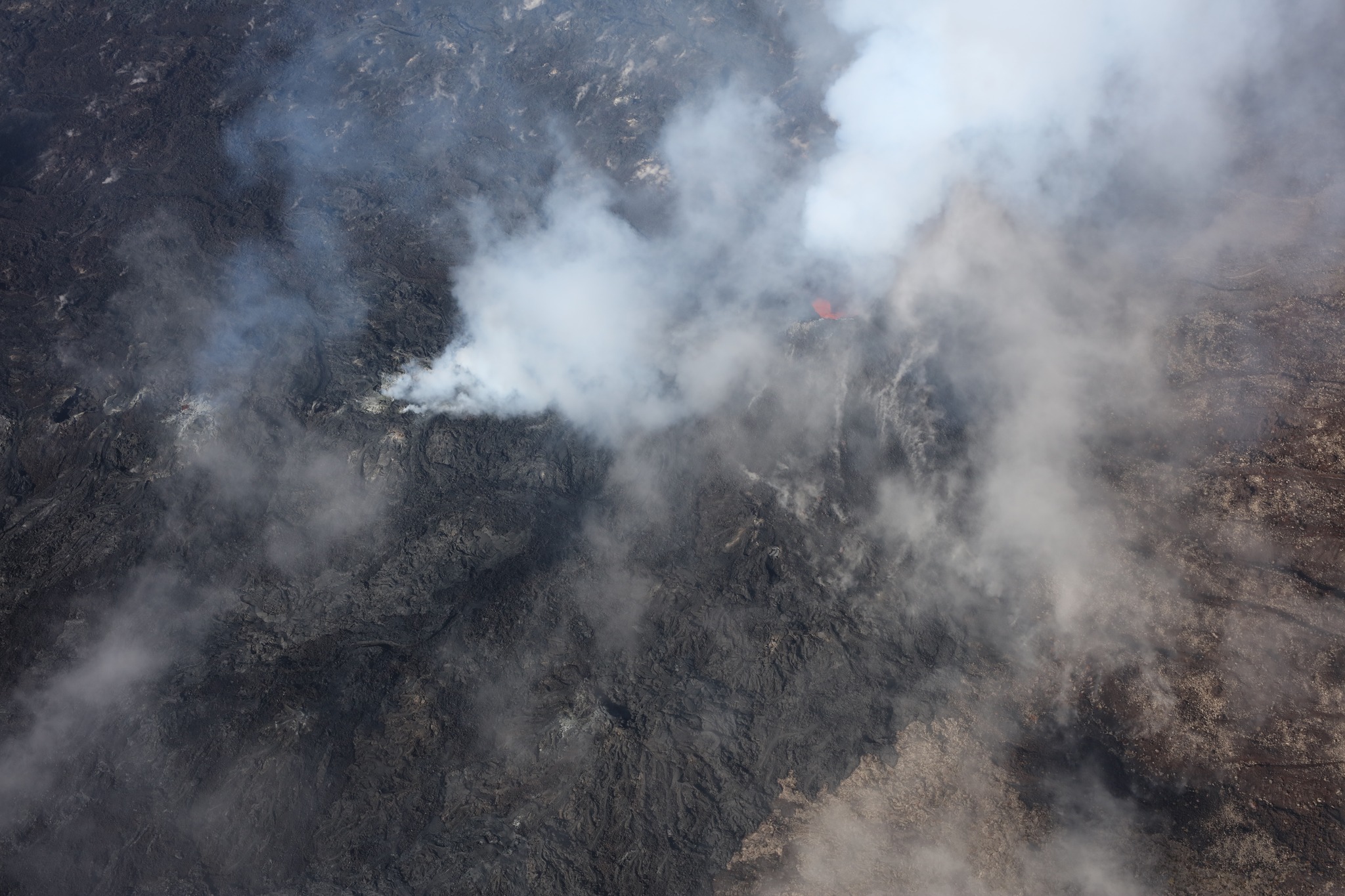
With the low surface activity, the morphology of the active volcanic cone – located southeast of the Enclos Fouqué at 1720 m altitude – hardly changes. Lava projections are rare and the flow of the lava takes place mainly in lava tunnels. The resurgence points – and therefore the visible flows – are currently located at distances between 1200 and 2500 m from the eruptive cone, i.e. up to a minimum altitude of 900 m.
The flow front has not changed since July 5 and is now frozen. It is located 1.8 km from the road.
The seismic activity recorded under the summit zone remains weak. Thus over the last 24 hours, a superficial volcano-tectonic earthquake has been recorded. This low seismic activity leads to a reduction in the risk of the appearance of a new crack and/or collapse in the crater, but does not mean that it can be excluded, as shown by the continuation of the summit inflation and the fluctuations in the amplitude of the tremor which are regularly observed.
Alert level: Alert 2-1 (eruption in the Enclos without any particular threat to the safety of people, property or the environment).
Source et photo : OVPF
Mexico , Popocatepetl :
July 30, 11:00 a.m. (July 30, 5:00 p.m. GMT)
Activity in the last 24 hours
Twenty-seven exhalations were detected, accompanied by water vapor, volcanic gases and sometimes slight amounts of ash. There was also a small explosion which occurred yesterday at 12:55 (local time).
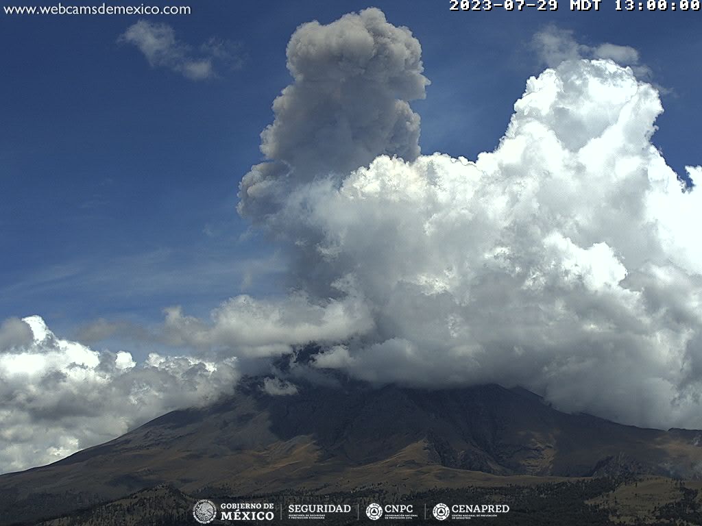
In addition, a volcano-tectonic type earthquake occurred today at 09:03 local time, with a calculated magnitude of 2.0.
At the time of this report, there is zero visibility due to cloudiness in the area. During the previous hours, an emission of water vapor and volcanic gases was observed which dispersed towards the West-North-West.
The Popocatépetl Volcanic Warning Traffic Light is located in Phase 2 Amarillo.
Source et photo : Cenapred.