September 01 , 2021 .
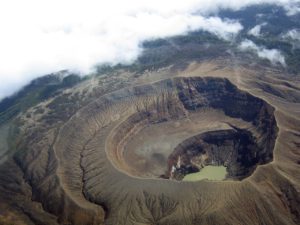
Hawaii , Kilauea :
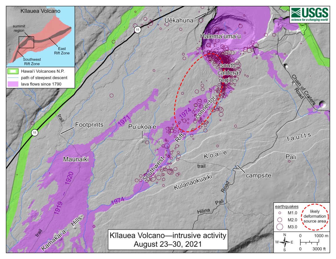
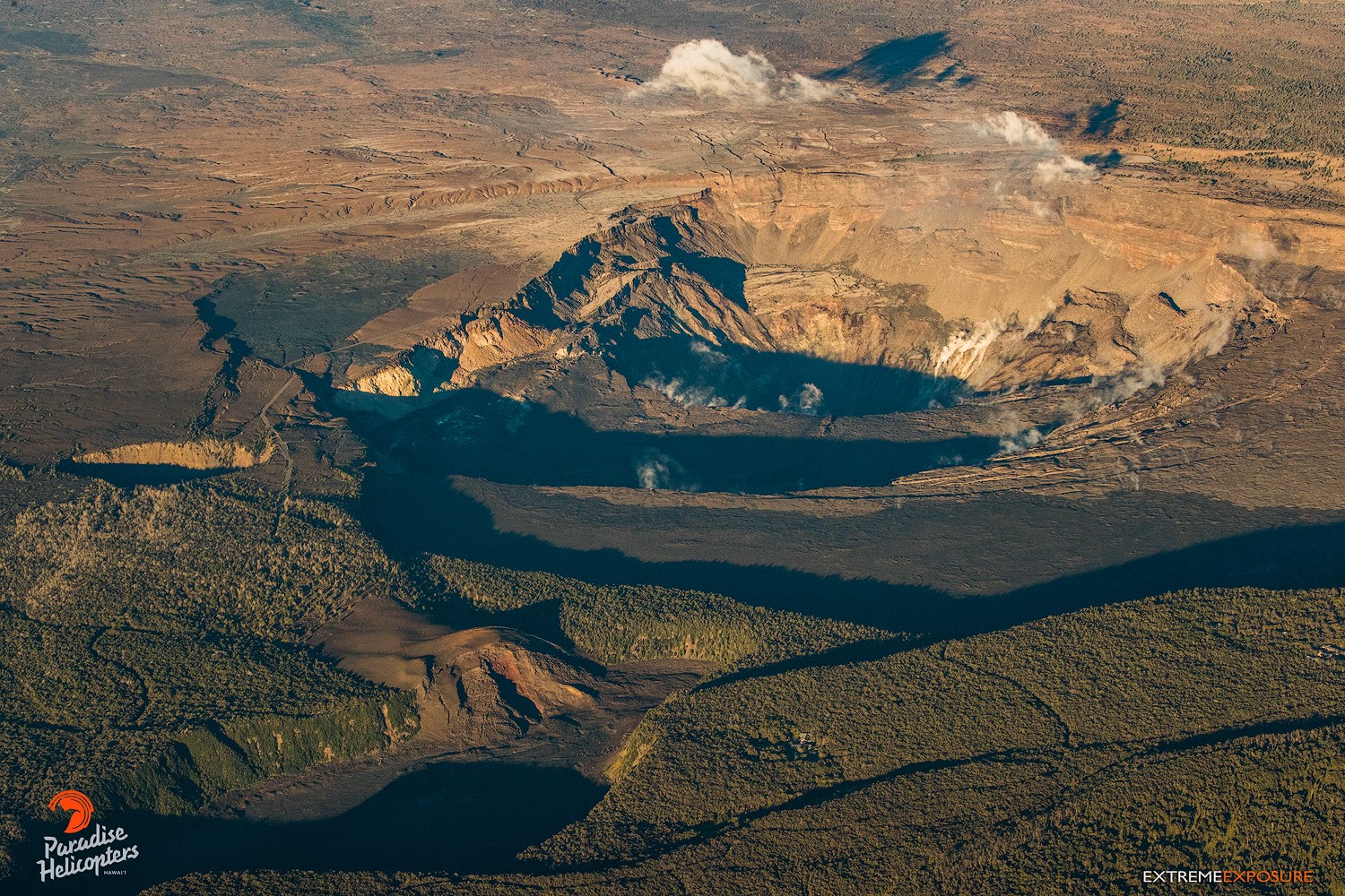
This map depicts the detected intrusive activity over the past week at Kīlauea Volcano. The initial swarm of small earthquakes from August 23–25 was centered in the south caldera region, as labelled on the map. A second swarm started late on August 26 in the same area; earthquake counts dropped the following day, but they have remained above background levels and epicenters have shifted further away from the caldera into the Southwest Rift connector. Ground deformation, as measured by tiltmeters and GNSS (GPS) instruments, appears to be focused within the dashed ellipse on the map. The Southwest Rift connector―also labelled on the map―is an underground passageway for magma into the Kīlauea Southwest Rift Zone, and for decades it has been a known source area for seismicity. The connector region is offset to the southeast from the main lineament of eruptive vents marking the Southwest Rift Zone, as evidenced by the 1971 eruptive vents and 1919–1920 Maunaiki lava shield on the map. Eruptions from the connector itself are thought to be rare, though a brief but spectacular eruption occurred in this area on December 31, 1974, producing a lava flow that travelled more than 12 km (7.5 mi) to the southwest.
19°25’16 » N 155°17’13 » W,
Summit Elevation 4091 ft (1247 m)
Current Volcano Alert Level: ADVISORY
Current Aviation Color Code: YELLOW
Activity Summary:
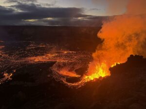
Kīlauea volcano is not erupting. Earthquake rates beneath the southern part of Kīlauea’s summit caldera and extending to the southwest have decreased over the past 24 hours. Ground deformation in Kīlauea’s summit region associated with the intrusion has ceased since yesterday afternoon, August 30. Other monitoring data streams, including sulfur dioxide emission rates and webcam views, do not show changes.
Summit Observations:
Within the past 24 hours, 33 earthquakes have been detected beneath the surface within and southwest of Kīlauea’s summit caldera, and extending to the Koa‘e fault zone. Most of the earthquakes are below magnitude 2 and are occurring approximately 1-4 km (0.6-2.5 mi) below the surface. Summit tiltmeters continued to record inflation and a change in the style of ground deformation until approximately noon yesterday, August 30, after which ground deformation associated with this event ceased. These observations suggest that new magma supply to the intrusion below the surface south of Kīlauea’s summit caldera has slowed or stopped.
Sulfur dioxide (SO2) emission rates remain at very low levels that have persisted since May 2021, when the most recent summit eruption ended. The most recent SO2 emission rates, measured on August 26, were 45 tonnes per day, close to levels associated with the non-eruptive period from late 2018 to late 2020 (less than 50 tonnes per day). This is significantly lower than emission rates that averaged over 800 tonnes per day from mid-February to mid-April when the summit eruption of Kīlauea was ongoing.
East Rift Zone Observations:
No unusual activity noted into the region. Ground deformation monitors indicate that the upper East Rift Zone—between the summit and Puʻuʻōʻō—is refilling at rates similar to those measured over the past 2 years and before the December 2020–May 2021 eruption in Halemaʻumaʻu. SO2 and hydrogen sulfide (H2S) emissions from Puʻuʻōʻō were below instrumental detection levels when last measured on January 7, 2021.
Source : USGS.
Photos : USGS , Bruce Omori.
Italy / Sicily , Etna :
Weekly bulletin, from August 23, 2021 to August 29, 2021 (date of issue August 31, 2021)
SUMMARY STATEMENT OF ACTIVITY
In view of the monitoring data, it is highlighted:
1) VOLCANOLOGICAL OBSERVATIONS: An episode of lava fountains at the Southeast Crater; pulsed degassing of the Bocca Nuova crater and ordinary degassing of the Voragine and Northeast craters.
2) SEISMOLOGY: Very weak seismic activity of fracturing. Average amplitude of the average low volcanic tremor with large and sudden fluctuations, up to high values, in conjunction with the episode of the lava fountain at the level of the Southeast Crater.
3) INFRASON: Moderately low infrasound activity with an increase phase coinciding with the lava fountain episode.
4) DEFORMATIONS: No significant change to report, apart from the inclinometric variation observed during the fountain on August 29, 2021.
5) GEOCHEMISTRY: SO2 flux at medium level
The flow of HCl is at an average level.
The flow of CO2 emitted by the soils shows a peak which culminates at 29 m.c. on medium-high values.
The partial pressure of CO2 dissolved in water does not show significant variations.
The helium isotope ratio appears on average to high values (latest data from 07/26/2021).
There are no updates for the C / S report.
6) SATELLITE OBSERVATIONS: The thermal activity in the summit area was at a high level in correspondence with the lava fountain of the Southeast crater on August 29, 2021.

VOLCANOLOGICAL OBSERVATIONS
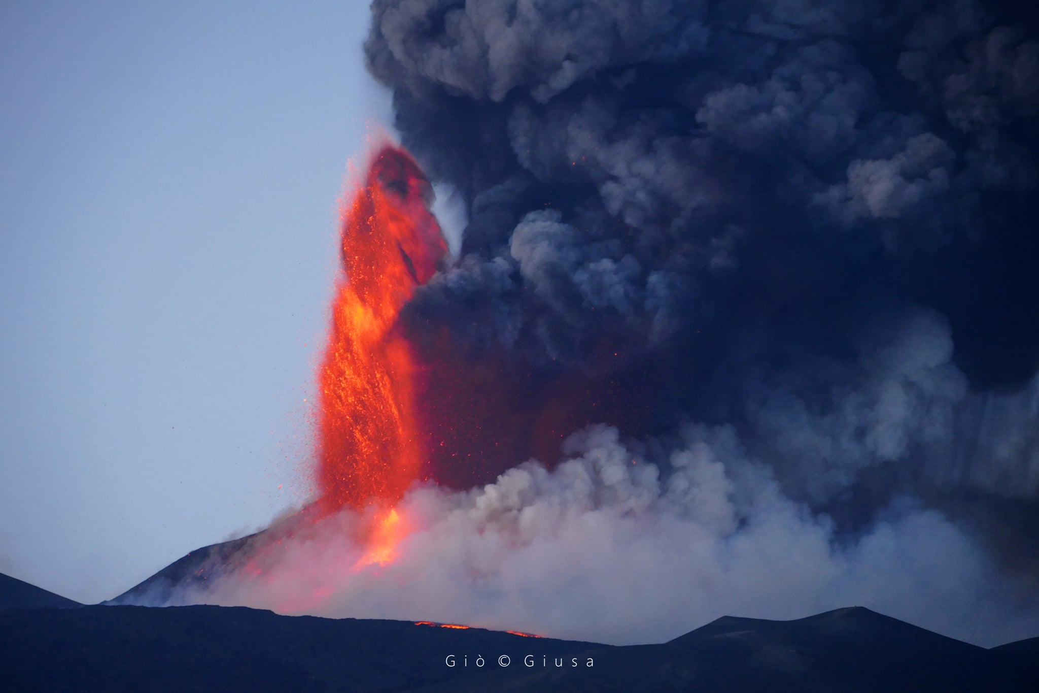
During the week of August 23 to 29, 2021, the monitoring of the volcanic activity of Etna was carried out thanks to the analysis of the images of the surveillance cameras of the INGV-Osservatorio Etneo (INGV-OE) and through direct observations of INGV – OE staff. Cloud cover present during part of certain days of the week limited the observation of volcanic activity. During the first days of the week, the activity at the summit craters of Etna consisted of the usual degassing, which maintained its pulsatile character at the crater of Bocca Nuova, already observed for several weeks. In the figure, the flow map issued on August 29 during the paroxysmal activity, the arm that descends into the Valle del Bove is partially mapped due to the presence of cloud cover which hampered its full observation. The map was produced with Sentinel 2 satellite images from August 30, 2021.

The Southeast Crater (SEC), which, after the paroxysmal episode of August 9, had remained in a calm state, produced an explosion at 3:30 p.m. UTC on August 27, with the emission of a modest amount of ash, which dispersed to the east. Further explosions occurred the following night and the morning of August 28, producing modest puffs of ash. On August 29 in the early afternoon, the Southeast Crater resumed its Strombolian activity, which activated after about an hour, and began to pass to the lava fountain stage with jets of about 400 m high and the consequent production of an ash column with a height of a few hundred meters. The phenomenon experienced oscillations with a slight decrease in explosive activity and then resumed with greater intensity, forming an eruptive column which reached a height of about 10 km. In parallel with the paroxysmal activity, two lava flows took place, one towards the Valle del Bove with the opening of an effusive vent at the base of the South-East Crater, and a second flow to the South-West, towards the Monte Frumento Supino. The direction of the winds coming from the West produced a fallout of ash and lapilli in the eastern sector which affected the towns of Fornazzo, Milo, San Alfio and Giarre.
Source : INGV.
Photos : Gio Giusa .
Italy , Stromboli :
Weekly bulletin, from August 23, 2021 to August 29, 2021 (date of issue August 31, 2021)
SUMMARY STATEMENT OF ACTIVITY:
In view of the monitoring data, it is highlighted:
1) VOLCANOLOGICAL OBSERVATIONS: During this period, a normal explosive activity of strombolian type was observed. The total hourly frequency of explosions fluctuated between average values (11-13 events / h) with the sole exception of August 23 with medium-high values (16 events / h). The intensity of the explosions was mainly low in the North crater area and medium-low in the Center-South area.

2) SEISMOLOGY: The seismological parameters monitored do not show significant variations.
3) DEFORMATIONS: The island’s soil deformation monitoring networks have shown no significant changes over the past week.
4) GEOCHEMISTRY: SO2 flux at a medium-low level.
The flow of CO2 from the ground to Pizzo Sopra la Fossa does not show significant variations and is at average values.
The weekly average C / S is at average values (C / S = 8.21).
The isotopic ratio of Helium dissolved in the thermal aquifer (latest data from 07/27/2021) was at medium – high values.
5) SATELLITE OBSERVATIONS: The thermal activity in the summit area is at a low level.
VOLCANOLOGICAL OBSERVATIONS
During the observation period, the eruptive activity of Stromboli was characterized thanks to the analysis of the images recorded by the surveillance cameras of the INGV-OE (altitude 190, Punta Corvi, altitude 400 and Pizzo). The explosive activity was mainly produced by 3 (three) eruptive chimneys located in the North crater area and by 6 (six) eruptive chimneys located in the Center-South crater area. All the vents are placed inside the depression which occupies the terrace of the crater.
Due to adverse weather conditions, the visibility of the crater terrace on August 28 was not sufficient for a correct description of the explosive activity.
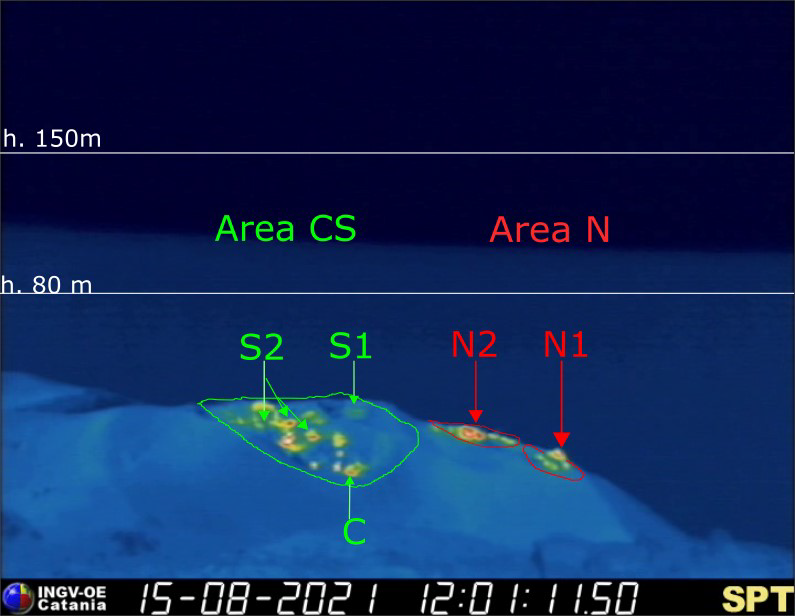
The crater terrace seen by the thermal camera placed on the Pizzo sopra la Fossa with the delimitation of the areas of the Center-South crater and the North crater area (ZONE N, ZONE C-S respectively). Abbreviations and arrows indicate the names and locations of active vents, the area above the crater terrace is divided into three height ranges relating to the intensity of the explosions.
The N1 crater located in the North zone, with two emission points, produced low intensity explosions (less than 80 m in height) emitting fine materials (ash) sometimes mixed with coarse materials (lapilli and bombs). Vent N2 showed low intensity explosive activity (less than 80 m in height) emitting fine materials sometimes mixed with coarse materials. The average frequency of explosions varied from 4 to 5 events / h.
In the Center-South zone, the S1 vent, located on the cone facing the Sciara, sporadically produced low-intensity explosions, emitting fine matter, sometimes mixed with larger materials, while the three vents located in the Sector S2 produced explosions, even simultaneously, of medium to low intensity (the products of some explosions reached a height of 120 m) emitting mainly coarse materials. Sector C produced degassing activities. The frequency of the explosions varied from 5 to 12 events / h.
Source : INGV.
Photos : INGV
La Réunion , Piton de la Fournaise :
Seismicity:
In August 2021, the OVPF recorded in the Piton de la Fournaise massif in total:
• 37 superficial volcano-tectonic earthquakes (0 to 2.5 km above sea level) below the summit craters;
• 2 deep earthquakes (below sea level);
• 311 collapses (in the Crater Dolomieu, the ramparts of the Enclos Fouqué and Piton de Crac, and the Rivière de l’Est).
The seismicity under the Piton de la Fournaise during the month of August 2021 remained low with an average of one superficial volcano-tectonic earthquake per day.
Deformation:
The building’s inflation, which began in April 2021, continued throughout August 2021. This inflation showed a pressurization of the superficial magmatic reservoir located at the
around 1.5-2 km deep.

Gas geochemistry:
CO2 concentration in the soil
Following the eruption of December 2020, a continuous increase in CO2 emissions from the soil was recorded at the level of the distal sites (Plaine des Cafres sectors) but also proximal (Gîte du volcano).
At remote sites, a trend reversal (decrease in CO2 emissions) occurred on February 12, 2021, witnessing a possible transfer of magma to more superficial crustal levels. A further increase followed this phase, with the largest increase recorded between April 4 and April 16.
On the proximal sites, the increase was continuous until early May, heralding the start of the long-lasting eruption from April 9 to May 24, 2021. From early to mid June 2021, a new trend of increasing CO2 flux was recorded both in the far field, and to a lesser extent in the near field (monthly bulletin for the month of June 2021). Since the distant field CO2 fluxes are stable on high values.
Balance sheet:
The building’s inflation and the CO2 levels in the soil which remained high in August 2021 witnessed magmatic transfers from deep areas to the superficial magmatic reservoir which continued after the end of the eruption of April 9-May 24, 2021.
Source : OVPF
Read the article : https://www.ipgp.fr/fr/ovpf/bulletin-mensuel-mercredi-1-septembre-2021
Photo : Imaz Press.
Saint Vincent , Soufrière :
La Soufrière Volcano – SCIENTIFIC UPDATE 31/08/21 1:00PM
-Seismic activity at La Soufrière, St Vincent has remained low since the tremor associated with the explosion and ash venting on 22 April. In the last week, there was a slight increase in the magnitude but it did not provide any indication of reactivation.
-Current activity is consistent with a period of unrest after an eruption. This can continue for weeks to months. While volcanic activity has been on a decline, there is the continued presence of near surface hot spots, daily seismic activity and persistent degassing.

– Lahar signals were observed: 4 on the 24 August and 1 on the 25 August in keeping with the rainfall that was experienced during this period.
– Clear atmospheric conditions at the volcano on 30 August enabled excellent views of the crater and observations indicate no major changes have occurred in the crater since the end of explosive activity on 22 April.
– There is a small, but not insignificant, possibility that magmatic activity might restart, should there be an influx of new magma from depth.
– The volcano is at alert level ORANGE.
Source et photo : UWI.
Iceland , Geldingadalur / Fagradalsfjall :
The lava flow from the Reykjanes Peninsula volcano has changed direction and is now heading south from Meradalir and towards Nátthagi.
The lava has reached half of the Nátthagi Valley and when it fills the meadow the lava will pass the barrier and eventually cut off the Suðurstrandarvegur road, if it continues to flow in the same way. A crack has opened in the side of the crater, causing lava to flow further south than before.

“The time until the lava reaches the barrier at the southern end is getting shorter. If this continues, it will eventually cross the barrier and the Suðurstrandarvegur road will be the next goal on the agenda, ”said Geophysicist Þorvaldur Þórðarsson. If the flow continues as it is now, it will happen in about two weeks. Once the barrier is overcome, it will take « a little time » to get back to the road. « As far as Suðurstrandarvegur is concerned, we are still talking about a few weeks anyway. »
The afternoon show ended quite abruptly around 4:00 p.m. as the volcano entered one of its now-familiar periods of calm, Met Office natural hazards specialist Lovísa Mjöll Guðmundsdóttir confirmed.
The level of volcanic activity remains low at the time of writing, but appears to be slowly increasing again. The volcano has been most active in the afternoon in recent days, Lovísa says.
Source et photo : RUV