June 02 , 2022.
La Réunion , Piton de la Fournaise :
Activity of the Piton de la Fournaise.
Seismicity
In May 2022, the OVPF-IPGP recorded at the level of the Piton de la Fournaise massif in total:
• 23 superficial volcano-tectonic earthquakes (0 to 2.5 km above sea level) under the summit craters;
• 2 deep earthquakes (below sea level);
• 619 landslides (in the Cratère Dolomieu, the ramparts of the Enclos Fouqué and the Piton de Crac, and the Rivière de l’Est).
The month of May 2022 will have been marked by low seismicity at the level of Piton de la Fournaise with an average of less than 1 superficial volcano-tectonic earthquake per day.
Most of these events were located below the eastern rim of the Dolomieu crater.
The month of May was also marked by many landslides (in the Cratère Dolomieu, the ramparts of the Enclos Fouqué and mostly at the broken of the Rivière de l’Est.
Deformation
After the end of the last eruption, on January 17, 2022, a slight recovery in peak inflation was recorded. This, after an acceleration in mid-April, stopped in mid-May.
Gas geochemistry
CO2 concentration in the soil:
A new increase was recorded both in the distal and near field at the end of February with a strong acceleration in mid-March 2022. This phase of increase lasted until May 5 in the distal field and until May 19 in the near field. Since then, a beginning of flux reduction has been recorded both in the near and distal field.
Source : OVPF.
Read the article : https://www.ipgp.fr/sites/default/files/ovpf_20220601_bullmensu.pdf
Photo : Nath Duverlie
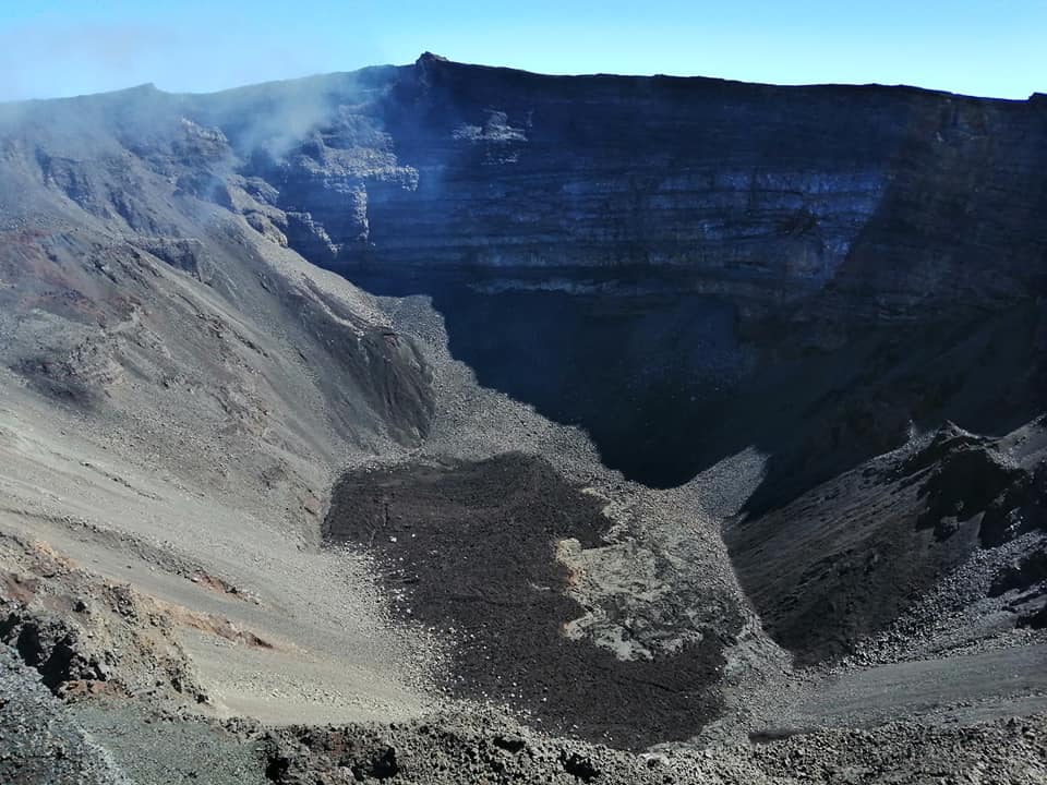
Indonesia , Dempo :
PRESS RELEASE ON THE PHREATIC ERUPTION OF G. DEMPO of MAY 31, 2022 AT 01.54 WIB. Wednesday, May 31, 2022 at 12:00 p.m. WIB.
The Dempo volcano (G. Dempo) in South Sumatra, has been on WASPADA alert (level II) since January 7, 2022. In 2021, there was an increase in seismicity in the form of the appearance of vibrations of continuous tremor from April to September 2021.
The character of Mount Dempo eruptions are predominant phreatic eruptions that occur suddenly, briefly, not preceded by clear precursor symptoms. The eruption produces sulphurous mud, pyroclastic materials and water from the crater lake, which can be life threatening. Eruption material is spreading locally only around the eruption centre/crater.
Visual observations in May 2022 showed the volcano was clearly visible until it was covered in fog. Smoke from the crater was not observed.
Recorded seismicity:
28 emission earthquakes,
1 low frequency earthquake,
1 deep volcanic earthquake,
1 local tectonic earthquake.
4 earthquakes felt, scale I to II MMI,
30 distant tectonic earthquakes,
Continuous tremor with an amplitude of 0.5-5 mm, mostly 0.5 mm.
On May 31, 2022, an ash eruption occurred at 01:54 WIB and was recorded on a seismograph with an amplitude of 35mm and an earthquake duration of 239 seconds. Ash rains occurred in North Pagar Alam and North Dempo sub-districts within a radius of about 5 km from the summit of Mount Dempo. The ash deposits adhere to the soil surface and the Pagar Alam plantation with a thickness of about 0.5 to 1 mm.
With Mount Dempo’s current level of activity, the potential danger is a phreatic eruption producing rains of ash and mud, as well as bursts of high concentration volcanic gas with limited distribution around the crater/peak. Phreatic eruptions can occur suddenly without being preceded by obvious symptoms of increase. The impact radius of falling material can reach 1 km around the crater, and the mud flows north for 2 km towards the opening of the crater. Ash rain can occur in all directions depending on wind direction and speed.
Based on the results of visual and seismic monitoring, Mount Dempo’s activity status through May 31, 2022, Mount Dempo’s activity level is still at the WASPADA Alert Level (Level II).

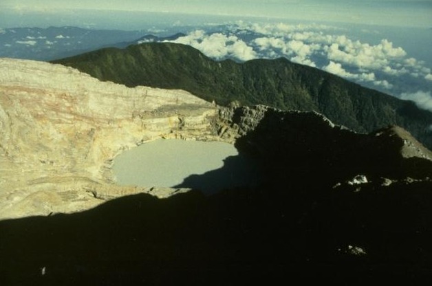
Dempo is a prominent stratovolcano that rises above the Pasumah Plain of SE Sumatra. The andesitic volcanic complex has two main peaks, Gunung Dempo and Gunung Marapi, constructed near the SE rim of a 3 x 5 km caldera breached to the north. The Dempo peak is slightly lower, and lies at the SE end of the summit complex. The taller Marapi cone was constructed within a crater cutting the older Gunung Dempo edifice. Remnants of seven craters are found at or near the summit, with volcanism migrating WNW over time. The large, 800 x 1100 m wide historically active crater cuts the NW side of the Marapi cone and contains a 400-m-wide lake located at the far NW end of the crater complex. Historical eruptions have been restricted to small-to-moderate explosive activity that produced ashfall near the volcano.
Source : PVMBG. GVP.
Photos : Ruska Hadian, 1989 (Observatoire volcanologique d’Indonésie). Mads N via Oystein Lund Andersen .
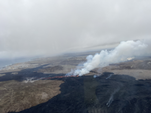
Indonesia , Lewotolok :
Update on volcanic activity at Mount Ili Lewotolok, May 31, 2022.
The current state of activity of the Ili Lewotolok volcano has been at alert level SIAGA (LEVEL III) since November 29, 2020. Visual observations in May 2022 showed eruptions were still occurring and smoke from the main crater was white , gray and black with a low intensity, thick, 50 to 1200 meters above the summit. The height of the eruption column varied from 100 to 500 meters, white to gray. Lava flows are generally still located in the crater area of the Ili Lewotolok volcano.
The seismicity of Mount Ili Lewotolok in May 2022 was still dominated by earthquakes linked to the release of matter/gas activities:
564 eruption earthquakes
3526 emission earthquakes
148 harmonic earthquakes
1449 non-harmonic earthquakes
34 shallow volcanic earthquakes
15 deep volcanic earthquakes
Continuous tremor with an amplitude of 0.1 to 20.9 mm (mainly 5 mm).
Slope distance measurement using the EDM method shows a fluctuating value in the range of 2 cm, and in general, inflation in this period tends to inflation.
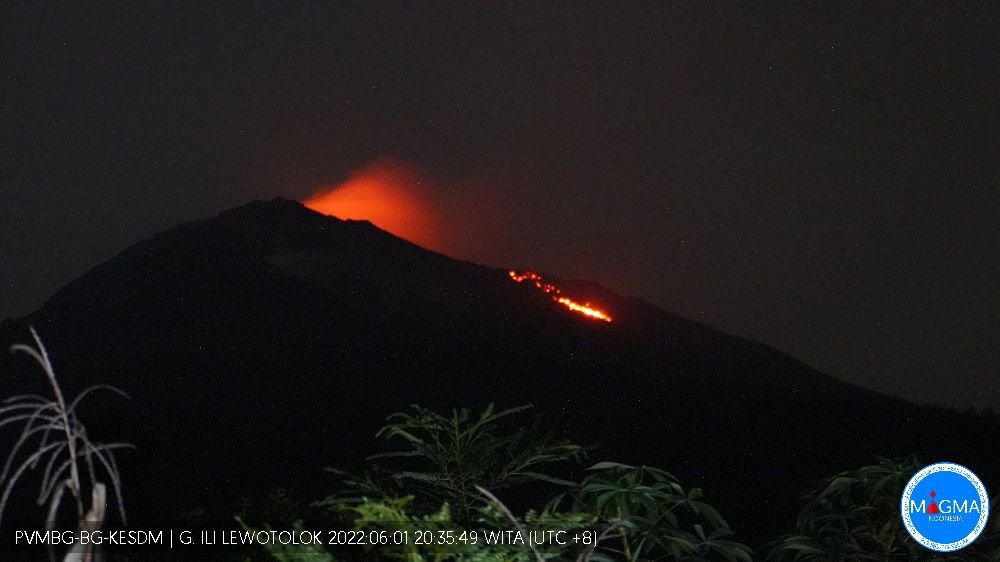
On May 31, 2022, lava flows crossed the eastern rim of the crater for 500 meters, but with a relatively small volume. This is believed to be due to more intense effusive eruptive activity (lava flows) at the end of May 2022, accompanied by a significant increase in swarm earthquakes and large non-harmonic tremors. Thus, there is an increase in eruptive material in the crater area, such that the eruptive material has exceeded the capacity of the crater. This lava flow leads to the village of Jontona which is on the east side with the nearest settlement about 4 km from the summit. The potential danger of this situation is the appearance of incandescent lava avalanches to the East-South-East with a sliding distance of about 1 to 2 km.
Based on current visual and instrumental data, the condition of Mount Ili Lewotolok until May 31, 2022 is still at LEVEL III (SIAGA). people around G. Ili Lewotolok as well as visitors / climbers / tourists are recommended not to do any activities within 3 km of the summit / crater of G. Ili Lewotolok.
Source : PVMBG
Photo : Magma Indonésie.
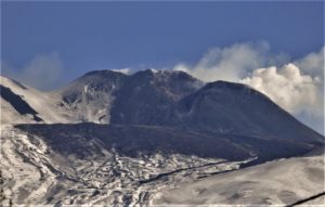
Italy / Sicily , Etna :
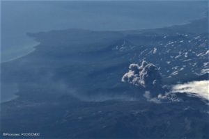
Communique on the activity of Etna, June 01, 2022, 21:04 (19:04 UTC).
The National Institute of Geophysics and Volcanology, Osservatorio Etneo, announces that a continuous emission of ash from the Southeast Crater began from 17:00 GMT, forming a volcanic ash plume that affects the South-South-East sector of the volcano.
In addition, according to an inspection carried out in the afternoon by INGV staff, the effusive activity produced by the Southeast Crater continues, the most advanced lava fronts are around 2100 m.
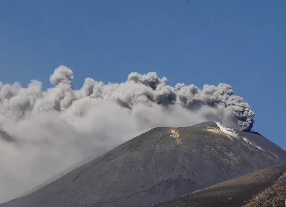
From the seismic point of view, the average amplitude of the volcanic tremor, while showing a slight decrease from 4:00 p.m. GMT, is currently in the upper range, with a tendency to decrease further. The source of the volcanic tremor is located under the Southeast Crater at an altitude of about 3000 m.
Infrasound activity is low.
With regard to ground deformations, the stations of the GNSS and tilt networks do not show significant variations.
Further updates will be communicated soon.
Source : INGV.
Photo : Etna Walk .
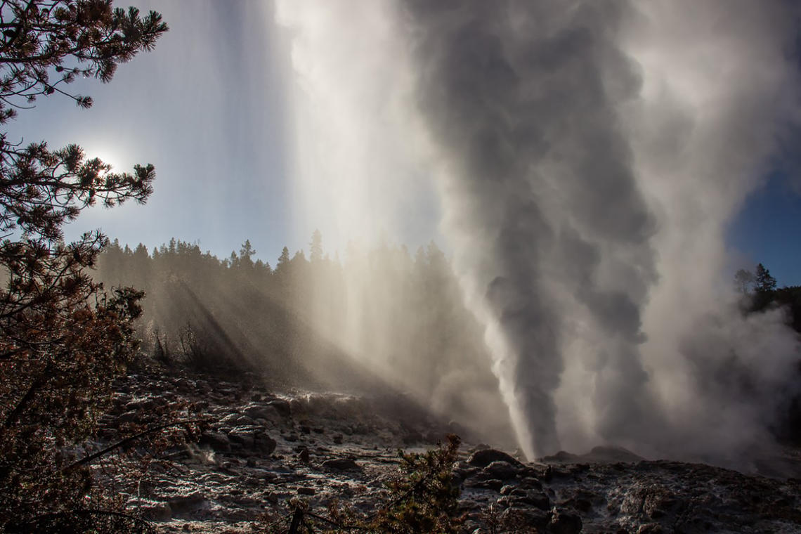
United-States , Yellowstone :
44°25’48 » N 110°40’12 » W,
Summit Elevation 9203 ft (2805 m)
Current Volcano Alert Level: NORMAL
Current Aviation Color Code: GREEN
Recent Work and News
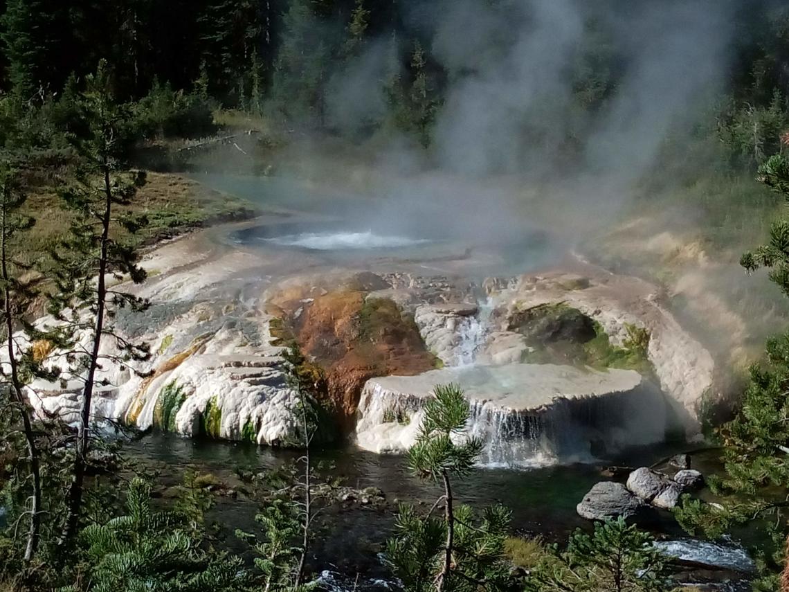
YVO scientists were in Yellowstone for several weeks during the month of May. Field work inlcuded mainternance of temperature monitoring stations in Norris Geyser Basin, deployment of 15 semipermanent GPS stations, and maintenance of continuous gas monitoring equipment near Mud Volcano. YVO scientists also gathered for their first in-person meeting in 4 years, discussing recent scientific results and revising the YVO response plan, which provides a guide for the scientific and hazards response to any geological event or unrest in the region.
Steamboat Geyser erupted twice during the past month, on May 4 and May 23; there have now been a total of 6 major water eruptions of the geyser in 2022. As of the end of May, the geyser was showing increasing levels of minor activity, so an eruption by early-mid June is likely. Just in time for the start of summer!
Seismicity
During May 2022, the University of Utah Seismograph Stations, responsible for the operation and analysis of the Yellowstone Seismic Network, located 87 earthquakes in the Yellowstone National Park region. The largest event of the month was a light earthquake of magnitude 4.2 located ~13 miles north of the East Entrance of Yellowstone National Park on May 11 at 7:32 AM MDT, and it was reported felt by people in the park and surrounding communities. This was the strongest earthquake to occur in the Yellowstone region since a M4.4 event in 2017. On average, an M4 event is located in or around Yellowstone National Park every few years.
May seismicity in Yellowstone was marked by two small swarms:
1) A swarm of 12 earthquakes, ~8 miles west of Old Faithful, Yellowstone National Park, occurred May 17–18. The largest earthquake of the swarm (magnitude 2.0) was on May 18 at 7:59 AM MDT.
2) A swarm of 10 earthquakes, ~5 miles north of West Yellowstone, MT, occurred May 8–9, with the largest earthquake (magnitude 2.3) taking place on May 8 at 11:02 AM MDT.
Earthquake sequences like these are common and account for roughly 50% of the total seismicity in the Yellowstone region.
Yellowstone earthquake activity remains at background levels.
Ground deformation
No significant changes in ground deformation patterns were observed in data from continuous GPS stations over the past several months. No deformation is apparent in a station near Norris Geyser Basin, and stations within Yellowstone Caldera continue to subside at an overall rate of 2–3 cm (1 in) per year. This subsidence has been ongoing since 2015.
Source : YVO.
Photos : thermal feature / Sara Peek , steamboat/Mara Reed .
Japan , Yakedake :
JMA raised the Alert Level for Yakedake to 2 (on a scale of 1-5) on 24 May, noting that the number of small volcanic earthquakes with epicenters near the summit began increasing around 2300 the day before. The report also noted that minor inflation near the summit was continuing. Daily small volcanic earthquakes continued to be counted through 31 May.
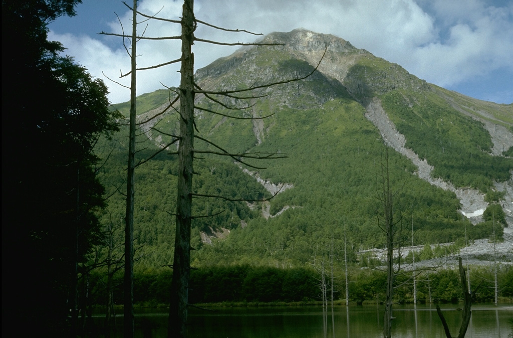
Yakedake rises above the popular resort of Kamikochi in the Northern Japan Alps. The small dominantly andesitic stratovolcano, one of several Japanese volcanoes named Yakedake or Yakeyama (« Burning Peak » or « Burning Mountain »), was constructed astride a N-S-trending ridge between the older volcanoes of Warudaniyama and Shirataniyama. Akandanayama, about 4 km SSW, is a stratovolcano with lava domes that was active into the Holocene. A 300-m-wide crater is located at the summit, and explosion craters are found on the SE and N flanks. Frequent small-to-moderate phreatic eruptions have occurred during the 20th century. On 11 February 1995 a hydrothermal explosion in a geothermal area killed two people at a highway construction site.
Sources : JMA , GVP.
Photo : Lee Siebert, 1977 (Smithsonian Institution).